HomeDiagramsDatabaseMapsForum About
     

Go Back   SkyscraperPage Forum > Regional Sections > Canada > Alberta & British Columbia > Calgary > Transportation & Infrastructure


Reply

 
Thread Tools Display Modes
     
     
  #1141  
Old Posted Aug 1, 2010, 3:17 PM
roccerfeller's Avatar
roccerfeller roccerfeller is offline
Registered User
 
Join Date: Jul 2010
Location: BC
Posts: 2,932
Quote:
Originally Posted by srperrycgy View Post
Few pics from my afternoon walk up to 69th St. The mosquitos were bad and they enjoyed feasting on me. The construction at Sarcee Tr. is increasing and the pedestrian path was poorly marked. ATCO Gas and Telus were both working on their respective utilities.

Excavation at 37th St.:


45th St. Station excavation:


New WB Lanes on 17th Ave. ready for paving:


Nice way to increase business, but how many labourers like lattes?


Oops. A nice wrench to forget. Looks like the piece was cast or was ready earlier in the month based on the date in the pic.


All of my July pictures:

http://www.flickr.com/photos/lrtincalgary/sets/72157624574284256/


You guys have mosquitoes in Calgary???

Thats looking REAL good btw guys. Im gonna look forward to visiting and checkin it out. Now if only we had as competent a city council here in the Peg (to get our RT in order)...
Reply With Quote
     
     
  #1142  
Old Posted Aug 1, 2010, 5:43 PM
mersar's Avatar
mersar mersar is offline
Registered User
 
Join Date: May 2006
Location: Calgary, AB
Posts: 10,083
Looking east towards the guideway
__________________

Live or work in the Beltline? Check out the Official Beltline web site here
Reply With Quote
     
     
  #1143  
Old Posted Aug 1, 2010, 5:58 PM
outoftheice outoftheice is offline
Registered User
 
Join Date: Jan 2009
Posts: 914
Great photos everybody! Does anyone know if the concrete for the guideway will evenutally be painted? Most of the new over-passes in Calgary feature the painted concrete and I find it really makes a difference!
Reply With Quote
     
     
  #1144  
Old Posted Aug 2, 2010, 12:58 AM
srperrycgy's Avatar
srperrycgy srperrycgy is offline
I'm the bear on the right
 
Join Date: Jun 2004
Location: Calgary (Killarney)
Posts: 1,670
Quote:
Originally Posted by outoftheice View Post
Great photos everybody! Does anyone know if the concrete for the guideway will evenutally be painted? Most of the new over-passes in Calgary feature the painted concrete and I find it really makes a difference!
In Calgary tradition, I'm sure that the guideway and supports will be "Banff Beiged" in good time.
__________________
Stevinder.
* * * * * *
Reply With Quote
     
     
  #1145  
Old Posted Aug 2, 2010, 6:27 PM
Mike Wilhelm Mike Wilhelm is offline
Registered User
 
Join Date: Jul 2009
Posts: 89
Quote:
Originally Posted by mr.steevo View Post
Hi,

We recently moved to the area so we aren't aware of the development of this station. From what I understand, MCF Housing for Seniors still owns the land next to Bow Tr. but has no immediate intentions to do anything with the property. Who knows if there will be another seniors complex. Still, I'm thinking about general accessability. The station in its current design is accessable but I just wonder how safe it will feel with the level of traffic up and down that roadway. Maybe it will be fine. Maybe not.

We do have concerns about traffic cutting through streets. I've noticed a lot more people speeding through playground zones while bumping over the traffic calming humps. I'm thinking some extra stop signs throughout the area would be a simple way of annoying people enough not to cut through. I know blocks and blocks of stop signs annoy me.

s.
We live on the North side of Bow and our son has had to cross the entire expressway to reach the eastbound bus, and to catch his school bus. I think crossing half a lane of traffic is better that what we have right now (and better than the seniors have now). The previous speeds on Bow will be permanently reduced. So the station will be more accessible than current transit options (but admittedly less convienient as some might hope).

I disagree that the station is inaccessible, but will agree that it might be inconvienent for some (as would be any future stop signs to others on the cut through streets). The station would have been more accessible with the plans we intially proposed (trench or underground) before the city decided to move the station to the middle of bow at grade.

The station design was altered (and defended within the community) as a result of the input of 12 non-community association residents of Shaganappi, one from Killarney, and one representing golf course players. MCF is intensely involved in developing a plan to increase the number of seniors at its site, likely in a larger building closer to the station - give them a call if you need further information.

A comprehensive traffic plan has been developed, and was extensively advertised within the community. We plan to implement it closer to the time the LRT is finished.
Reply With Quote
     
     
  #1146  
Old Posted Aug 3, 2010, 2:45 AM
Xelebes's Avatar
Xelebes Xelebes is offline
Sawmill Billowtoker
 
Join Date: Nov 2006
Location: Rockin' in Edmonton
Posts: 14,026
Quote:
Originally Posted by srperrycgy View Post
In Calgary tradition, I'm sure that the guideway and supports will be "Banff Beiged" in good time.
Better than Edmonton Beiged, lol.
Reply With Quote
     
     
  #1147  
Old Posted Aug 3, 2010, 3:50 AM
mersar's Avatar
mersar mersar is offline
Registered User
 
Join Date: May 2006
Location: Calgary, AB
Posts: 10,083

Looking at the guideway from the 14th Street off ramp from westbound Bow Trail
__________________

Live or work in the Beltline? Check out the Official Beltline web site here
Reply With Quote
     
     
  #1148  
Old Posted Aug 3, 2010, 2:34 PM
MalcolmTucker MalcolmTucker is offline
Registered User
 
Join Date: May 2007
Posts: 11,629
Quote:
Originally Posted by Mike Wilhelm View Post
We live on the North side of Bow and our son has had to cross the entire expressway to reach the eastbound bus, and to catch his school bus. I think crossing half a lane of traffic is better that what we have right now (and better than the seniors have now). The previous speeds on Bow will be permanently reduced. So the station will be more accessible than current transit options (but admittedly less convienient as some might hope).

I disagree that the station is inaccessible, but will agree that it might be inconvienent for some (as would be any future stop signs to others on the cut through streets). The station would have been more accessible with the plans we intially proposed (trench or underground) before the city decided to move the station to the middle of bow at grade.

The station design was altered (and defended within the community) as a result of the input of 12 non-community association residents of Shaganappi, one from Killarney, and one representing golf course players. MCF is intensely involved in developing a plan to increase the number of seniors at its site, likely in a larger building closer to the station - give them a call if you need further information.

A comprehensive traffic plan has been developed, and was extensively advertised within the community. We plan to implement it closer to the time the LRT is finished.
The station was moved to the middle of Bow as part of the plan to 'protect' communities from an intrusive guideway that would attract ruffians, and cause derailed LRVs to fall on a school yard. (and just by happenstance protect the views of some million dollar homes at the same time). In any case, when the station was to be on the north side of Bow, an over or underpass was still in the plans.

As for exposed elevators vs a true station head - the system already has stand alone elevators, see Brentwood Station's park and ride elevator. When the community was fine with eliminating the bridge, of course the city jumped at the chance to save money - it doesn't mean a station head can't, or won't, or shouldn't be added in the future when demand warrants it and capacity is constrained on Bow Trail beyond what can already flow through the lower bottlenecks.
Reply With Quote
     
     
  #1149  
Old Posted Aug 3, 2010, 2:55 PM
Mike Wilhelm Mike Wilhelm is offline
Registered User
 
Join Date: Jul 2009
Posts: 89
Quote:
Originally Posted by Sir.Humphrey.Appleby View Post
The station was moved to the middle of Bow as part of the plan to 'protect' communities from an intrusive guideway that would attract ruffians, and cause derailed LRVs to fall on a school yard. (and just by happenstance protect the views of some million dollar homes at the same time). In any case, when the station was to be on the north side of Bow, an over or underpass was still in the plans.
Sorry, this is totally incorrect. 26 St was always at grade, elevated line or not. An overpass and underpass was never in the plans. The city never had it's act together on that one, but thanks (again) for creating that perception.

The issue with the elevated guildeway was that it was "introduced", and never in the "25 year old" (the quote is the mayor's) plan. You might understand that if you bought a house in full expectation of LRT, but not in expectation of an unnecessary and expensive guideway, you might ask them to go back to the original plan.

The guideway, as it turned out, was simply a response to a sudden change in political direction; a literal "work around" by administrators, so they could avoid roadwork and utilities issues and meet a newly introduced project deadline.

Yes,the station can be upgraded later, and a grade separation at 26th is inevitable.
Reply With Quote
     
     
  #1150  
Old Posted Aug 3, 2010, 3:37 PM
MalcolmTucker MalcolmTucker is offline
Registered User
 
Join Date: May 2007
Posts: 11,629
^ If my memory serves me the local station community consultation committee were shown station designs with a head end, back in 2008?

Also, the 'avoided' road work from the original 1980s plan were not minor things, likely running into the multiple hundreds of millions of dollars. The plans were changed from median, to side, back to median - so what? The city still had the south side 'landing' for the pedestrian bridge for many years (as in, they had bought some houses out, unless they bought out the SE corner of 12th Ave and 26th for a substation or other purpose)

The 83 plans don't even have a station at 26th? Is all change bad?

On the 11th page of the West LRT Functional Study - Update 1988 (Part 3) 8MB you can see clearly marked an overpass to the then 29th St station. Oh, and it looks like the 26th St location was for substations according to the same page.

Edit: found this in the 2007 report:
Quote:
The 26 Street SW Station further complicates matters by increasing the overall footprint.
Originally foreseen as a simple walk-on station platform, with relatively simple construction, this
station would require significantly more infrastructures than anticipated. The pedestrian volumes
of even a lightly-used station are predicted to overwhelm the cross-traffic signal times, at the
Bow Trail / 26 Street SW intersection, thereby requiring a grade-separated pedestrian crossing.

As well, the existing catchment for 26 Street SW Station is largely shared by that of the
Westbrook Mall Station. For these reasons, it is proposed that alignment at 26 Street SW be
designed to accommodate a side platform station, but that actual station construction be
deferred until population density warrants an additional stop.

Last edited by MalcolmTucker; Aug 3, 2010 at 4:30 PM.
Reply With Quote
     
     
  #1151  
Old Posted Aug 3, 2010, 7:27 PM
Mike Wilhelm Mike Wilhelm is offline
Registered User
 
Join Date: Jul 2009
Posts: 89
I was chair of the commitee. The station plans were not well advanced at the first meeting. We were shown a conceptial drawing with a switchback style pedestrian bridge, similar to Bridgeland. The station head in that drawing was on the east side of the station (a white massing block only), and with the bridge would have dominated the top of the hill. We saw it one more time, and never saw it again. It never got into even the initial architectual drawings.

No, all change is not bad. Unnecessary change, made soley to comfort administrators, adverse to resident property interests, made after we bought our properties, is a problem. Keep in mind the city went out of its way to elevate the line to accomodate industrial parking interests on 10th Avenue, and this was a change to the better for them. To my knowledge, it was granted without any publically documented consultation process.

The addition of the 26 St station was a surprise in 2008, and received positively. In 2009, we actually floated the idea of eliminating the station all together, but political forces at city hall wanted to spent the extra money.

However, no plan ever had a separation of grade at 26 St.
Reply With Quote
     
     
  #1152  
Old Posted Aug 3, 2010, 7:39 PM
You Need A Thneed's Avatar
You Need A Thneed You Need A Thneed is offline
Construction Enthusiast
 
Join Date: Feb 2007
Location: Castleridge, NE Calgary
Posts: 5,892
I definitely remember seeing plans for a station head with pedestrian bridge at 26th street on the city's website at one point. Is that what you guys are talking about?

The LRT line itself was never grade separated, but the pedestrians were.
Reply With Quote
     
     
  #1153  
Old Posted Aug 4, 2010, 9:40 PM
yyc_engineer's Avatar
yyc_engineer yyc_engineer is offline
Registered User
 
Join Date: Jun 2010
Location: Somewhere between OOL and MCY
Posts: 427
26th Street aka "Shaganappi Point" will be an interesting station, it's either gonna be a catalyst for some more development in the area or just a filler between Westbrook and DT, as the catchment area is arguably one of the smallest on the line..

In some other news, the third section of the guideway is almost complete, I was out there this afternoon and snapped a couple shots which I pathetically attempted to stitch together (in PAINT)... Also went down into the trench west of 37th Street (around 39th) where the first section of mudslab for the trench sections has been placed. You really get a cool sense of what it will be like to ride the train in a trench, different than being on grade that is for sure...

I think that this is gonna be one of the coolest (if not the coolest) line to ride on in Canada in terms of elevations/scenery, the closest lines I can see are Canada/Millennium/Expo on the skytrain, but on Canada line you are underground coming into DT and Expo/Millennium don’t have the grades the WLRT has...but maybe I’m biased...any thoughts??

Photo’s attached...Cheers,


Guideway view from skate park


Trench Section looking East at 39th

Reply With Quote
     
     
  #1154  
Old Posted Aug 4, 2010, 10:24 PM
fusili's Avatar
fusili fusili is offline
Retrofit Urbanist
 
Join Date: Sep 2007
Posts: 6,692
Thanks for the photos yycengineer. I agree that the west LRT will be an interesting ride. Can't make comparisons with other lines in North America, as I haven't rode them, but this will definitely be awesome.
Reply With Quote
     
     
  #1155  
Old Posted Aug 5, 2010, 2:51 AM
bestnickever bestnickever is offline
Registered User
 
Join Date: Feb 2008
Posts: 44
Quote:
Originally Posted by yyc_engineer View Post

I think that this is gonna be one of the coolest (if not the coolest) line to ride on in Canada in terms of elevations/scenery, the closest lines I can see are Canada/Millennium/Expo on the skytrain, but on Canada line you are underground coming into DT and Expo/Millennium don’t have the grades the WLRT has...but maybe I’m biased...any thoughts??
Yeah, it's gonna be a nice ride in from 69 St. It'll likely be the only LRT line anywhere descending some 800 feet. 4000' ish up top to.....what's downtown...3200' thereabout?
Reply With Quote
     
     
  #1156  
Old Posted Aug 5, 2010, 3:31 AM
MrBigStuff MrBigStuff is offline
Urbanite by Choice
 
Join Date: Nov 2007
Location: Calgary, AB
Posts: 876
Quote:
Originally Posted by bestnickever View Post
Yeah, it's gonna be a nice ride in from 69 St. It'll likely be the only LRT line anywhere descending some 800 feet. 4000' ish up top to.....what's downtown...3200' thereabout?
Those altitudes sound pretty close. Top of "Broadcast Hill" is at 4,000 ft. ASL. and the downtown core, as far as I know, is at or near 3200 ft. ASL.
That wil be a good climb for the trains in the winter - I hope there will be lots of sand boxes for the LRT operators to get sand from to sand up the tracks when the going gets rough.
Reply With Quote
     
     
  #1157  
Old Posted Aug 9, 2010, 10:30 PM
yyc_engineer's Avatar
yyc_engineer yyc_engineer is offline
Registered User
 
Join Date: Jun 2010
Location: Somewhere between OOL and MCY
Posts: 427
More Pics

Hey guys,

I took a few more snaps of the Elevated Guideway and Sunalta Station Area. I'm gonna post them in this thread cuz I think they are pretty sweet but I was just wondering what protocol is for uploading a lot of pictures, do you guys like seeing them here or are they just clogging the forum? Should I just leave them on my flikr?

http://www.flickr.com/photos/51553246@N07/

Cheers,


New Skateboard Ramp??


First Shot from on top of the guideway - looking East


Looking West...I'm not gonna lie it's pretty cool to be one of the first up here!


Sunalta Station Platform from below


Sunalta Station Platform from above


Looking West from Sunalta
Reply With Quote
     
     
  #1158  
Old Posted Aug 9, 2010, 10:45 PM
fusili's Avatar
fusili fusili is offline
Retrofit Urbanist
 
Join Date: Sep 2007
Posts: 6,692
Please, please, please keep posting photos. I think I speak for everyone when I say I love them. Really cool to see the progress of this thing.
Reply With Quote
     
     
  #1159  
Old Posted Aug 9, 2010, 10:53 PM
You Need A Thneed's Avatar
You Need A Thneed You Need A Thneed is offline
Construction Enthusiast
 
Join Date: Feb 2007
Location: Castleridge, NE Calgary
Posts: 5,892
yup, keep posting the pictures, they are great!
Reply With Quote
     
     
  #1160  
Old Posted Aug 9, 2010, 10:57 PM
Metro-One's Avatar
Metro-One Metro-One is online now
Registered User
 
Join Date: Sep 2008
Location: Japan
Posts: 18,021
Quote:
Originally Posted by yyc_engineer View Post

I think that this is gonna be one of the coolest (if not the coolest) line to ride on in Canada in terms of elevations/scenery, the closest lines I can see are Canada/Millennium/Expo on the skytrain, but on Canada line you are underground coming into DT and Expo/Millennium don’t have the grades the WLRT has...but maybe I’m biased...any thoughts??
While I am a huge fan of this LRT extension, I still think for interesting / scenic rides on mass transit skytrain in Vancouver takes the cake (for Canada that is).

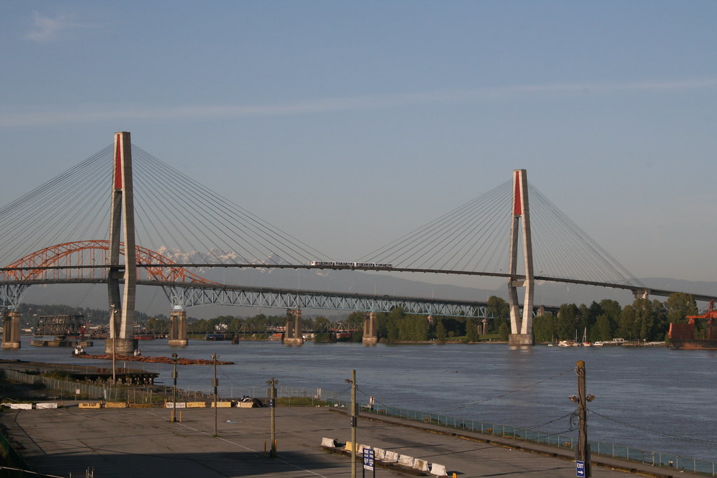
And to me, this here is the hands down masterpiece of skytrain, and nothing else in Canada compares; the Expo Line Fraser River crossing:


Pic is my own.
my flickr account: http://www.flickr.com/photos/30634635@N03/

Not to mention the north arm cable bridge over the Fraser on the C-line, along with the cool flyover train interchange on the C-line, and all of the views on the E/M lines, and even the underground stations downtown to add variety.


But still, great pics on this thread, keep them coming!
__________________
Bridging the Gap
Check out my Flickr: https://www.flickr.com/photos/30634635@N03/with/29495547810/ and Youtube channel https://www.youtube.com/channel/UCV0_0h9qKlhxXFxuAey_q6Q
Reply With Quote
     
     
This discussion thread continues

Use the page links to the lower-right to go to the next page for additional posts
 
 
Reply

Go Back   SkyscraperPage Forum > Regional Sections > Canada > Alberta & British Columbia > Calgary > Transportation & Infrastructure
Forum Jump


Forum Jump


All times are GMT. The time now is 10:13 AM.


Powered by vBulletin® Version 3.8.7
Copyright ©2000 - 2026, vBulletin Solutions, Inc.