HomeDiagramsDatabaseMapsForum About
     

Go Back   SkyscraperPage Forum > Regional Sections > United States > Pacific West > Portland > Transportation & Infrastructure


Reply

 
Thread Tools Display Modes
     
     
  #2781  
Old Posted Aug 18, 2009, 5:46 AM
PacificNW PacificNW is offline
Registered User
 
Join Date: Jul 2001
Location: Arizona
Posts: 3,116
I have always thought the same thing....in fact, the whole I-5 corridor from Eugene to (whatever that Canadian highway is called once you cross the border) Vancouver, B.C.
Reply With Quote
     
     
  #2782  
Old Posted Aug 22, 2009, 8:24 PM
electricron's Avatar
electricron electricron is offline
Registered User
 
Join Date: Aug 2008
Location: Granbury, Texas
Posts: 3,616
Lightbulb

The problem with true (150+ mph) high speed rail using center medians of freeways are the curves, which were designed for maximum speeds 80 mph or less.

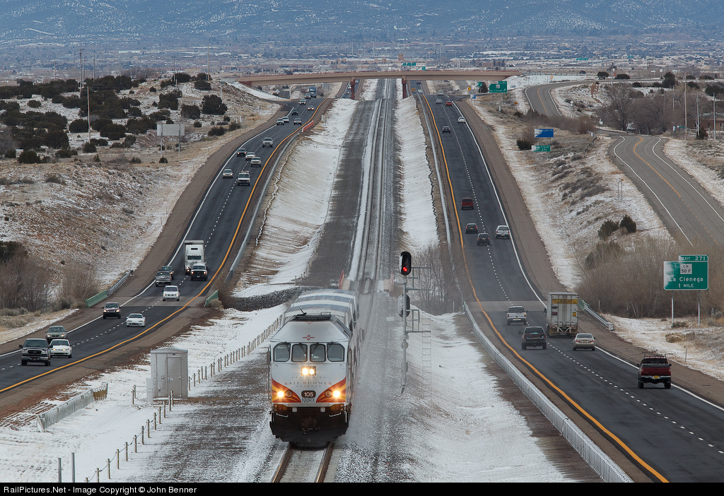
Building a single track or double track railroad line in the center median in rural areas isn't the problem as New Mexico has shown with the Railrunner expansion into Santa Fe. The problem is that high speed trains need larger radius curves to maintain higher speeds.

New Mexico's Railrunner trains maximum speeds are 79 mph.


Railrunner Phase II Cost Allocation by Project Element
1. Stations $16.5 million
2. Track/Signal Improvements $188.1 million
3. Cars & Locomotives $36.1 million
4. Project Development Costs $7.3 million
5. Dispatch/Communications $4.0 million
6. Rights of Way $2.8 million
Total $254.8 million

If this total is added to the $125 million price tag for Phase I, which includes the $50 million for the purchase of the track, plus $20 million for the purchase of the track for the portion between Bernalillo and Lamy, the grand total is $399.8 million.

NMDOT spent $188.1 Million on laying new tracks in the new right-of-way. They built 18 miles of track, therefore spent approximately $10 Million/mile.

Railrunner Phase II uses previously existing track from Bernalillo to the base of La Bajada, a hill south of Santa Fe. Next it runs on newly built track on new right-of-way from CP Madrid, for five miles and then in the I-25 median into Santa Fe for 13 miles, at CP Hondo, where it uses an improved Santa Fe Southern Railway track from I-25 to the terminal at the Santa Fe Railyard.

New Mexico's DOT got lucky, as all the overpasses over I-25 were built like the photo above. No reworking of the bridges were required, but the track grade had to be lowered to get 22 feet vertical clearances above top of rail.


Last edited by electricron; Aug 22, 2009 at 8:57 PM.
Reply With Quote
     
     
  #2783  
Old Posted Aug 22, 2009, 9:05 PM
Okstate's Avatar
Okstate Okstate is offline
Registered User
 
Join Date: May 2007
Location: SE PDX
Posts: 1,367
^ Why 22 ft.?
Reply With Quote
     
     
  #2784  
Old Posted Aug 22, 2009, 10:54 PM
electricron's Avatar
electricron electricron is offline
Registered User
 
Join Date: Aug 2008
Location: Granbury, Texas
Posts: 3,616
Lightbulb

Quote:
Originally Posted by Okstate View Post
^ Why 22 ft.?
Because that's the standard clearance for bridges/structures over railroad tracks in some states, including Texas. In other states the minimum standard vertical clearance is 23 feet.

Hudson River tunnels into New York City maximum vertical clearance are 14 feet, 6 inches.
Bombardier MultiLevel railcars are 14 feet, 6 inches tall.
Nippon Sharyo (Budd) Galley railcars are 15 feet, 6 inches tall.
Bombardier's BiLevel railcars are 15 feet, 11 inches tall.
Amtrak's Superliner railcars are 16 feet, 2 inches tall.

Last edited by electricron; Aug 23, 2009 at 1:12 PM.
Reply With Quote
     
     
  #2785  
Old Posted Aug 22, 2009, 11:54 PM
Okstate's Avatar
Okstate Okstate is offline
Registered User
 
Join Date: May 2007
Location: SE PDX
Posts: 1,367
Thanks
Reply With Quote
     
     
  #2786  
Old Posted Aug 23, 2009, 12:48 AM
bvpcvm bvpcvm is offline
Registered User
 
Join Date: Apr 2004
Location: Portland
Posts: 2,793
There is, in fact, a median along I-5 all the way from Tualitin to Salem, and there's only one curve (just south of the Wilamette River) before you get into Salem. Not quite as sure about a median along I-5 from Salem to Eugene, but most of it is definitely pretty straight. I wonder if building tracks along this median would be any more expensive than upgrading UP's tracks and signaling?
Reply With Quote
     
     
  #2787  
Old Posted Aug 23, 2009, 1:39 PM
electricron's Avatar
electricron electricron is offline
Registered User
 
Join Date: Aug 2008
Location: Granbury, Texas
Posts: 3,616
Lightbulb

Just one? I counted 17 curves along I-5 from the Marquam Bridge to Salem, and another 15 curves to Eugene. Besides, there's not enough room in the median, it's ~40 feet wide north of Salem, and ~60 feet wide south of Salem.

I-25 in New Mexico is at a minimum 150 feet wide where the tracks were laid. Where the tracks turn into Santa Fe, the median width shrinks to ~60 feet, but by that time the tracks have left the median.

True High Speed trains are going to need at least 25 feet clearances between tracks and structures. To simplify, that means a minimum of 50 feet clearances for single track, and 75 feet clearances for double tracks (double mainline or single mainline track and passing siding).

I-5, as built, isn't wide enough for High Speed Trains.
Reply With Quote
     
     
  #2788  
Old Posted Aug 23, 2009, 3:31 PM
bvpcvm bvpcvm is offline
Registered User
 
Join Date: Apr 2004
Location: Portland
Posts: 2,793
From Tualitin, as I said, to Salem (well - to Chemawa) there's only one curve. On either end, of course, there would be issues. As far as I'm concerned they could just build something light rail-like with limited stops and DMUs (running at, say 80mph). At curves they might need to do some engineering, but I imagine the cost savings from not acquiring the land would provide an offset. It's at least worth looking into.
Reply With Quote
     
     
  #2789  
Old Posted Aug 24, 2009, 4:11 AM
electricron's Avatar
electricron electricron is offline
Registered User
 
Join Date: Aug 2008
Location: Granbury, Texas
Posts: 3,616
Lightbulb

I still think there are more curves than just the one south of the Wilsonville bridge. 40 feet wide medians are just barely wide enough for single track. More width in the median is needed for must have passing tracks.

Of course, one direction of I-5 pavement could be moved to make room for tracks in the median, but that's going to increase the costs. Since New Mexico's Railrunner averaged spending $10 Million/mile, that's the least it is going to cost in Oregon. Oregon construction costs could be twice the construction costs in New Mexico, if not more.

Assuming the same average construction costs, and the distance from Tualitin to Salem per yahoo maps is 35.66 miles, we're discussing at least $356.6 Million just for the track work.
It's 65.57 miles from Salem to Eugene, so add another $655.7 Million, for a grand total over a $Billion, just for tracks in the median of I-5. If Oregon construction costs are twice as much as New Mexico, it's over $2 Billion.

For Cascades service speeds, I believe it should be far cheaper to upgrade one of the two existing railroad corridors. Much of the existing railroad infrastructure can be used, although some of it will need to be reworked for faster train speeds.

The total construction costs for the WES train service, all the costs including the vehicles and train stations, was $166 Million. The WES route is 14.7 miles in length. Therefore, the average costs was $ 11.3 Million/mile.
Reply With Quote
     
     
  #2790  
Old Posted Sep 12, 2009, 3:30 AM
NJD's Avatar
NJD NJD is offline
Registered User
 
Join Date: Aug 2006
Location: Portland
Posts: 632
Trimet's rail map is finally looking good


...they forgot to close the green/yellow loop at PSU though.
Reply With Quote
     
     
  #2791  
Old Posted Sep 12, 2009, 7:26 AM
erinkg erinkg is offline
Registered User
 
Join Date: Jan 2009
Posts: 29
They actually make you get off the max at PSU - you can't continue around the loop and ride the train back up. I'm guessing this is to kick the bums off, but I'm not sure. So, I guess the map is right?
Reply With Quote
     
     
  #2792  
Old Posted Sep 12, 2009, 8:35 AM
cityscapes's Avatar
cityscapes cityscapes is offline
Registered User
 
Join Date: Apr 2009
Location: Portland
Posts: 723
I can't wait to see what the map looks like when Barbur and the Yellow/Orange lines are built.
Reply With Quote
     
     
  #2793  
Old Posted Sep 12, 2009, 3:32 PM
RED_PDXer RED_PDXer is offline
Registered User
 
Join Date: Dec 2007
Location: Portland, OR
Posts: 823
Imagine what it'll look like if Portland's streetcar system is developed with a few more routes.. I doubt they'll use colors to denote those.. I'd guess they'll use letters.. Regardless, it'll look pretty impressive!
Reply With Quote
     
     
  #2794  
Old Posted Sep 13, 2009, 12:13 AM
bvpcvm bvpcvm is offline
Registered User
 
Join Date: Apr 2004
Location: Portland
Posts: 2,793
Quote:
Originally Posted by RED_PDXer View Post
Imagine what it'll look like if Portland's streetcar system is developed with a few more routes.. I doubt they'll use colors to denote those.. I'd guess they'll use letters.. Regardless, it'll look pretty impressive!
I would have thought so too, but some while back on either portlandstreetcar.org or portlandtransport.org it was announced that the current streetcar line is the "amber" line and the eastside loop is the "aqua" line. Better to stick with letters, IMHO.
Reply With Quote
     
     
  #2795  
Old Posted Sep 17, 2009, 3:44 AM
northbay's Avatar
northbay northbay is offline
Sonoma Strong
 
Join Date: Mar 2006
Location: Cotati - The Hub of Sonoma County
Posts: 1,881
anybody wanna post pix of this newly opened line? or r u guys in portland content to just let ur threads die with no 'closure' (or should i say opener)?
Reply With Quote
     
     
  #2796  
Old Posted Sep 17, 2009, 4:18 AM
nobody nobody is offline
Ah-choo.
 
Join Date: Sep 2006
Location: Portland
Posts: 433
That's the positive attitude that will motivate people to snap pictures. I'm sure your employees, er, forum members will get to it when they can.
Reply With Quote
     
     
  #2797  
Old Posted Sep 17, 2009, 4:09 PM
northbay's Avatar
northbay northbay is offline
Sonoma Strong
 
Join Date: Mar 2006
Location: Cotati - The Hub of Sonoma County
Posts: 1,881
Quote:
Originally Posted by nobody View Post
That's the positive attitude that will motivate people to snap pictures. I'm sure your employees, er, forum members will get to it when they can.
no need to get 🞵🞵🞵🞵-hurt. I was just surprised nobody has taken pix. in any other city, people wouldve taken pix by now (or revived the thread that hadnt been touched in almost a year)

sorry if people take an interest in ur citys transportation system
Reply With Quote
     
     
  #2798  
Old Posted Sep 17, 2009, 4:32 PM
nobody nobody is offline
Ah-choo.
 
Join Date: Sep 2006
Location: Portland
Posts: 433
Do you want some cheese with that?
Reply With Quote
     
     
  #2799  
Old Posted Sep 17, 2009, 4:48 PM
JordanL JordanL is offline
Registered User
 
Join Date: Jun 2008
Posts: 1,004
Quote:
Originally Posted by northbay420 View Post
no need to get 🞵🞵🞵🞵-hurt. I was just surprised nobody has taken pix. in any other city, people wouldve taken pix by now (or revived the thread that hadnt been touched in almost a year)

sorry if people take an interest in ur citys transportation system
I'll see if I can snap some later today or tomorrow.
Reply With Quote
     
     
  #2800  
Old Posted Sep 17, 2009, 5:26 PM
PacificNW PacificNW is offline
Registered User
 
Join Date: Jul 2001
Location: Arizona
Posts: 3,116
I agree with you northbay420. I was hoping to see some related pics of the new line, (taken by anyone on the forum), by this time.
Reply With Quote
     
     
This discussion thread continues

Use the page links to the lower-right to go to the next page for additional posts
 
 
Reply

Go Back   SkyscraperPage Forum > Regional Sections > United States > Pacific West > Portland > Transportation & Infrastructure
Forum Jump


Forum Jump


All times are GMT. The time now is 11:43 AM.


Powered by vBulletin® Version 3.8.7
Copyright ©2000 - 2026, vBulletin Solutions, Inc.
