HomeDiagramsDatabaseMapsForum About
     

Go Back   SkyscraperPage Forum > Regional Sections > Canada > Alberta & British Columbia > Vancouver > Transportation & Infrastructure


Closed Thread

 
Thread Tools Display Modes
     
     
  #3541  
Old Posted Aug 10, 2009, 2:16 AM
windscar windscar is offline
 
Join Date: Jan 2009
Posts: 82
Very nice map Deasine, wish I could make them like that. You should send that to Translink, who knows maybe they would use it.
     
     
  #3542  
Old Posted Aug 10, 2009, 2:18 AM
mr.x's Avatar
mr.x mr.x is offline
 
Join Date: Dec 2003
Posts: 12,805
Nice map.


I thought it was odd that they left out the 97 and 99 B-Lines on the new on-board train maps.
     
     
  #3543  
Old Posted Aug 10, 2009, 5:06 AM
Millennium2002 Millennium2002 is offline
 
Join Date: Jun 2009
Posts: 1,742
Hmm... as much as showing detail is nice wouldn't that clutter the map? NYC trains also don't show the whole route (even on the newest trains).

- Allan Kuan
     
     
  #3544  
Old Posted Aug 10, 2009, 5:16 AM
mr.x's Avatar
mr.x mr.x is offline
 
Join Date: Dec 2003
Posts: 12,805
^ yea, the Canada Line stations and information regarding the Canada Line's extra airport surcharge was a bit unnecessary....it takes up too much space that could've been used to make the station name text for the Expo and M-Lines bigger.
     
     
  #3545  
Old Posted Aug 10, 2009, 5:21 AM
argon007 argon007 is offline
 
Join Date: Nov 2006
Posts: 159
very nice map.
however you miss surrey in zone three.
     
     
  #3546  
Old Posted Aug 10, 2009, 5:30 AM
deasine deasine is offline
 
Join Date: Mar 2007
Posts: 5,747
I added the Canada Line because this map was for Wikipedia

No... Surrey is on there...
     
     
  #3547  
Old Posted Aug 10, 2009, 5:38 AM
argon007 argon007 is offline
 
Join Date: Nov 2006
Posts: 159
no, i mean the name...where is the name of surrey in zone three? i did not see that name.
     
     
  #3548  
Old Posted Aug 10, 2009, 5:44 AM
deasine deasine is offline
 
Join Date: Mar 2007
Posts: 5,747
It's there... =)

But yes, TransLink has their new SkyTrain route maps which are totally fine. This wasn't made as like my version of it... but rather to update a few wikipedia pages.
     
     
  #3549  
Old Posted Aug 10, 2009, 6:07 AM
Metro-One's Avatar
Metro-One Metro-One is offline
 
Join Date: Sep 2008
Posts: 18,039
Great map, only one thing i would change: curve all the corners of the transit lines or right angle all of the corners. For some reason the mix of sharp and curved angles rubs me the wrong way. Also you should say "Westcoast express to Pitt Meadows, Maple Ridge & Mission" since both Pitt Meadows and Maple Ridge are absent from the map and it only says "Mission" after PoCo. Again, totally minor, and i may just be me. Overall awesomeness!
     
     
  #3550  
Old Posted Aug 10, 2009, 7:26 PM
mr.x's Avatar
mr.x mr.x is offline
 
Join Date: Dec 2003
Posts: 12,805
From the Buzzer:


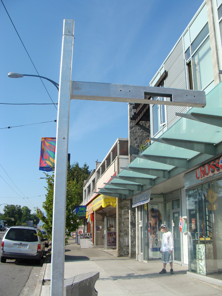
The metal poles at some Main Street bus stops will carry real-time bus arrival displays this fall.


What are those weird poles at the Main Street bus stops?

If you’ve been to Main Street lately, you might have noticed that some bus stops have gained a weird metal pole that juts out horizontally.

Well, they aren’t just bizarre metal sculpture art! The poles are for real-time bus arrival displays, which will be installed by the fall.

The displays are part of the Main Street Urban Showcase Project, an innovative transportation improvement program launched in 2004 and jointly funded by Transport Canada (through the Urban Transportation Showcase Program), TransLink and the City of Vancouver.
(Check out the official Main Street Showcase page for more on the project!)

A broad suite of improvements like urban design (like bus and pedestrian bulges), new transit technology (including these displays), and a fleet of larger buses (the new trolleys on the #3 route!) all contribute to more efficient traffic flows and make Main Street more welcoming for pedestrians, drivers, and transit riders, in turn serving the ultimate goal of reducing greenhouse gas emissions.

So the real-time arrival displays are just another feature to improve the transit experience and make your wait a bit less onerous.

The displays will be installed at 29 stops: stops with high volumes of riders, and stops with transfers to other routes. Information from the GPS system on the buses is used to estimate the next bus’s arrival time.

They’re similar to the displays previously found on the 98 B-Line route—however, a key difference is that we’re using a different supplier with improved technology.

As well, in the coming months, we’re working to let on-bus technology ‘talk’ to traffic signals to help keep the buses on time—this is also known as “transit signal priority,” and it’s explained quite well on this page. (I’ll have more on that when the project gets underway!)

And by the way, Main Street was chosen for this pilot project because is the busiest local bus route in Metro Vancouver — it carries more riders than many light rail systems in North America!


An example of the real-time information displays that will be installed at 29 Main Street stops. (Although the 301 Rotnes is not coming to Main St!)
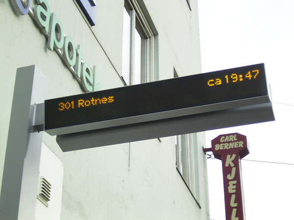


Jhen has said the display above is from Germany....and they can arrange the route number/arrival time/actual time in different ways. They certainly look quite sleek....hopefully they won't be vandalized.

     
     
  #3551  
Old Posted Aug 10, 2009, 8:14 PM
deasine deasine is offline
 
Join Date: Mar 2007
Posts: 5,747
Quote:
Originally Posted by mr.x View Post
They’re similar to the displays previously found on the 98 B-Line route—however, a key difference is that we’re using a different supplier with improved technology.
They are quite different in how it works. The 98 B-Line ones weren't entirely GPS based, but a mixture of technologies that caused it constantly crashing. What angers me know is that the 98 B-Line ones are used for time display: BUT THEY DISPLAY THE WRONG TIME!

I thought this project will never get lifted off the ground. Good to see that something is done... Can't wait now!

Now... let's get more of these up for other bus routes like 99, 41/43, etc.
     
     
  #3552  
Old Posted Aug 10, 2009, 9:23 PM
SpongeG's Avatar
SpongeG SpongeG is offline
 
Join Date: Jun 2006
Posts: 40,137
cool stuff
     
     
  #3553  
Old Posted Aug 12, 2009, 2:24 AM
ravman ravman is offline
 
Join Date: Mar 2008
Posts: 560
19:09 Sky train back to regular service. Delays expected. 18:35 Due to a Police Incident at Metrotown Station the Sky Train is operating between Waterfont and Joyce Station and back.Expo Line is running between King George Station and Edmonds Station and back. Millenium line is running between VCC Clark Station and Columbia Station. There is a bus bridge running between Joyce Station and Edmonds Station stopping at Patterson, Metrotown, Royal Oak and Edmonds Station.

The reason:

Explosives experts in Burnaby detonate pipe bomb
At southeast corner of Metrotown
Dave White / Kim Seale BURNABY (NEWS1130) 2009-08-11 18:30
Bookmark

BURNABY (NEWS1130) - The bomb squad has removed and detonated a pipe bomb that was discovered at the southeast corner of the Metrotown complex, not far from the Bread Garden.

People in nearby high rise condos were kept away from the park. Stay tuned to News1130 for traffic updates in the area.
http://www.news1130.com/news/local/more.jsp?content=20090811_190238_9620
     
     
  #3554  
Old Posted Aug 12, 2009, 3:10 AM
mr.x's Avatar
mr.x mr.x is offline
 
Join Date: Dec 2003
Posts: 12,805
Commercial Drive Station earlier
     
     
  #3555  
Old Posted Aug 12, 2009, 3:18 AM
deasine deasine is offline
 
Join Date: Mar 2007
Posts: 5,747
They still should've continued SkyTrain service, just not having it stop at Metrotown. Service was horrendous and confusing.
     
     
  #3556  
Old Posted Aug 12, 2009, 3:21 AM
ravman ravman is offline
 
Join Date: Mar 2008
Posts: 560
they had a notice on the TV screens at skytrain stations...
     
     
  #3557  
Old Posted Aug 12, 2009, 3:39 AM
deasine deasine is offline
 
Join Date: Mar 2007
Posts: 5,747
^ Yes.


Photography by Deasine - Hosted on Facebook - Creative Commons Protected
     
     
  #3558  
Old Posted Aug 12, 2009, 5:22 AM
Vancity's Avatar
Vancity Vancity is offline
 
Join Date: Jan 2009
Posts: 1,637
Quote:
Originally Posted by mr.x View Post
Commercial Drive Station earlier
What time of the day was that? Those crowds remind me of the crowds in HK, but it's almost always like that throughout the day. We really need to expand the transit system. Bring on the Olympic Line (streetcar), and expand the skytrain system in the lower mainland, not only in Vancouver, but it needs to eventually get throughout Surrey.

Transit system needs to be much stronger in Richmond. The C-line will help, but there is a lot that still can be done.
     
     
  #3559  
Old Posted Aug 12, 2009, 5:25 AM
GeeCee's Avatar
GeeCee GeeCee is offline
 
Join Date: Jan 2009
Posts: 2,816
Quote:
Originally Posted by Vancity View Post
What time of the day was that? Those crowds remind me of the crowds in HK, but it's almost always like that throughout the day. We really need to expand the transit system. Bring on the Olympic Line (streetcar), and expand the skytrain system in the lower mainland, not only in Vancouver, but it needs to eventually get throughout Surrey.

Transit system needs to be much stronger in Richmond. The C-line will help, but there is a lot that still can be done.
That was while service was disrupted due to today's incident at Metrotown..
     
     
  #3560  
Old Posted Aug 12, 2009, 5:48 AM
jlousa's Avatar
jlousa jlousa is offline
 
Join Date: Jun 2006
Posts: 8,371
Wow seems like someone is in a rush.

Quote:
Notice is hereby given by the South Coast British Columbia Transportation Authority (“TransLink”) of its intent to contract with PTV America (the “Supplier”) to model and analyze the operational and functional requirements for the UBC Hub.

TransLink has chosen to directly award this contract and not to call for vendor proposals for the following reasons:
1. Single/Select Supplier: more than one Supplier exist, but only one is qualified/capable/available to provide the goods/services; and
2. Product Requirements and Compatibility: compatibility/integration with existing equipment/technology necessitates use of specific Supplier.

PTV America and its team have expertise on this project. This work is to update previous modeling work done by PTV America.
Between 2004 and 2007, PTV America, Inc. and its team of consultants, ARUP and Delcan were contracted to model and assess operating scenarios of the proposed UBC HUB, an underground transit terminal, tunnel, intersection, above ground passenger plaza and on-street trolley facility.
The UBC Hub is being designed and built by UBC to TransLink’s specifications. TransLink is responsible for the transit specific components of the hub, including the ITS terminal management system. UBC postponed this project in mid-2007. UBC is now ready to recommence work on the Hub. TransLink must revise all modeling and assessments previously completed by PTV, incorporating fleet, ridership, route changes since 2004 and updated network and ridership projections as well as the revised Hub design.
UBC’s design and construction schedule is aggressive; it is imperative that the modeling work be completed within 8 weeks of receiving the revised conceptual design from UBC. The modeling will indicate if refinement to the design or operations are necessary prior to construction commencing in September 2009
     
     
This discussion thread continues

Use the page links to the lower-right to go to the next page for additional posts
 
 
Closed Thread

Go Back   SkyscraperPage Forum > Regional Sections > Canada > Alberta & British Columbia > Vancouver > Transportation & Infrastructure
Forum Jump


Forum Jump


All times are GMT. The time now is 9:04 PM.


Powered by vBulletin® Version 3.8.7
Copyright ©2000 - 2026, vBulletin Solutions, Inc.