HomeDiagramsDatabaseMapsForum About
     

Go Back   SkyscraperPage Forum > Regional Sections > Canada > Ontario > Ottawa-Gatineau > Transportation


Reply

 
Thread Tools Display Modes
     
     
  #3781  
Old Posted Apr 16, 2009, 3:16 PM
Ryersonian Ryersonian is offline
 
Join Date: May 2008
Posts: 91
Where was the Cougar?
Reply With Quote
     
     
  #3782  
Old Posted Apr 16, 2009, 3:44 PM
lrt's friend lrt's friend is online now
 
Join Date: Dec 2006
Posts: 12,815
just east of Bank Street between Blossom Park and Leitrim in the Greenbelt. It was a few years ago, and of course, these reports are always suspect. It was in someone's yard.
Reply With Quote
     
     
  #3783  
Old Posted Apr 17, 2009, 12:44 AM
eternallyme eternallyme is offline
 
Join Date: Mar 2009
Posts: 5,243
Quote:
Originally Posted by lrt's friend View Post
There is a bit of difference with the 94. At least the 94 makes all trips downtown. With the 98 and 99, many or most trips behave like local routes and end at the first Transitway station. When the current numbering system was developed, routes numbered under 100 were supposed to give you direct service downtown.
We'll have to see what they come up with ultimately. I suggested that all-day service downtown is warranted on the new 99.

Here is how I think the route network should - ultimately, after rapid transit is fully implemented - be numbered:

1-19: Local routes to downtown Ottawa
20-89: Local routes inside the Greenbelt
90-99: Rapid Transit (LRT/BRT, ultimately all LRT) routes to downtown Ottawa
100-109: Rapid Transit (BRT) routes entirely outside downtown
110-119: Local routes through the Greenbelt, regardless of area
120-199: Local routes outside the Greenbelt (in the suburbs)
200-299: Express and feeder routes outside the Urban Transit Area, mostly contracted out (including outside Ottawa)
300-399: Community routes
400-499: Scotiabank Place service
500-699: School routes (added the 500s to accomodate more; 500s could be for private and separate schools and 600s for public schools)
700-799: Internal numbering for special services (i.e. Sno-Bus, Tulip Festival service)
800-899: Early morning routes
900-999: Employee shuttles

In most cases, the tens digit should represent the direction served (except for the 110s, 400s and rapid transit):

0 and 1 - Downtown and central Ottawa
2 and 3 - East
4 - Southeast
5 and 6 - West
7 - Southwest
8 and 9 - leave unused, protect for Quebec side if a single bi-provincial transit authority is created as I believe there should be; 8 would be north/northwest and 9 northeast

For many urban routes, the routings may not change but the numbers would drop by 100 - for example, Route 146 could become Route 46. (Some routes would be renumbered differently or restructured though if their numbering does not fit well). There would be no routes numbered 200-219.
Reply With Quote
     
     
  #3784  
Old Posted Apr 17, 2009, 12:58 AM
p_xavier p_xavier is offline
 
Join Date: Dec 2006
Posts: 3,568
Quote:
Originally Posted by eternallyme View Post
We'll have to see what they come up with ultimately. I suggested that all-day service downtown is warranted on the new 99.

Here is how I think the route network should - ultimately, after rapid transit is fully implemented - be numbered:
Why not letters for LRT? I find Ottawa's numbering system too complicated as it is. In what cognitive aspect is 90-99 is put as BRT in a visitor's mind?
Reply With Quote
     
     
  #3785  
Old Posted Apr 17, 2009, 1:01 AM
p_xavier p_xavier is offline
 
Join Date: Dec 2006
Posts: 3,568
Quote:
Originally Posted by Ryersonian View Post
Where was the Cougar?
It was last seen downtown.

Reply With Quote
     
     
  #3786  
Old Posted Apr 17, 2009, 1:02 AM
Jamaican-Phoenix's Avatar
Jamaican-Phoenix Jamaican-Phoenix is offline
 
Join Date: Jun 2007
Posts: 3,561
Quote:
Originally Posted by d_jeffrey View Post
It was last seen downtown.


Reply With Quote
     
     
  #3787  
Old Posted Apr 18, 2009, 1:49 AM
eternallyme eternallyme is offline
 
Join Date: Mar 2009
Posts: 5,243
Here is my thinking for the ultimate network (this is entirely LRT when fully built out, and NOT to scale). Of course this is decades away if ever built (and I didn't take into account further growth beyond the planned boundaries except in the Southeast area). The Central, West-Central, East-Central and Southeast (Phase 1) sections are shared with multiple lines.


Station Listing – Numerical

West-Central LRT

1 Lincoln Fields
2 Woodroffe
3 Dominion
4 Westboro
5 Tunney’s Pasture
6 Bayview

Central LRT

7 LeBreton
8 Lyon/Kent
9 Metcalfe/O’Connor
10 Rideau Centre
11 UOttawa
12 Lees
13 Hurdman

Southeast LRT, Phase 1

14 Lycee Claudel
15 Smyth
16 Riverside
17 Pleasant Park
18 Billings Bridge
19 Heron
20 Walkley

East-Central LRT

21 Train
22 St. Laurent
23 Cyrville
24 Blair

East LRT (Orleans)

25 Canotek
26 Jeanne d’Arc
27 Place d’Orleans
28 Fallingbrook
29 Trim

Cumberland LRT

30 Pineview
31 Blackburn Hamlet
32 Chapel Hill
33 Mer Bleue
34 Avalon
35 Millennium

Southeast LRT, Phase 2

36 Albion
37 Lorry Greenberg
38 Conroy
39 Hawthorne
40 Russell Road
41 Ramsayville
42 Southeast Town Centre
43 Carlsbad

South LRT (Riverside South/Leitrim)

44 Riverview
45 Limebank
46 South Airport Industrial
47 Bowesville
48 Leitrim

Airport LRT

49 Airport

South-Central LRT

50 Lester
51 South Keys
52 Greenboro
53 Confederation
54 Carleton
55 Carling
56 Gladstone

West LRT (Kanata)

57 Scotiabank Place
58 Terry Fox
59 Eagleson
60 Moodie
61 Bayshore
62 Pinecrest
63 Queensview

Southwest LRT (Barrhaven)

64 Barrhaven Centre
65 Strandherd
66 Longfields
67 Fallowfield
68 Grenfell
69 West Hunt Club
70 Craig Henry/Knoxdale
71 Baseline
72 Queensway/Iris

Northwest LRT (Aylmer)

73 Des Cedres
74 Aylmer Centre
75 Glenwood/Wychwood
76 Deschenes
77 Rivermead
78 Champlain
79 Moussette
80 Tetreau/UQO
81 Chaudière

Northeast LRT (Gatineau)

82 Montcalm
83 Montclair/Galeries
84 Lac Leamy
85 Pointe-Gatineau
86 Les Promenades
87 Lausanne/Tecumseh
88 Vieux-Gatineau
89 Labrosse
90 Lorrain
91 Templeton-Est
92 Aeroparc
Reply With Quote
     
     
  #3788  
Old Posted Apr 18, 2009, 3:35 AM
Franky's Avatar
Franky Franky is offline
 
Join Date: Apr 2008
Posts: 1,551

Any idea how much track that amounts to?

Urbanaut claims elevated double-track complete systems can be installed for $17.5M USD per km.
http://www.urbanaut.com/Cost%20Data%204.htm

$5B would be 285 km of 2 lane elevated guideway. Some sections would not need to be elevated, so would be cheaper, other challenging sections would probably cost more.
Reply With Quote
     
     
  #3789  
Old Posted Apr 18, 2009, 1:48 PM
eternallyme eternallyme is offline
 
Join Date: Mar 2009
Posts: 5,243
It's certainly not cheap and would take decades to construct for sure. I based it on 2035 boundaries. Lower-density areas at the fringes are not included (which is why I didn't extend the Northeast line to Buckingham or the West line into Stittsville, for instance).

How I think the Southeast extension should be built: it should be done in the median of Hunt Club Road. After passing Greenboro Station (South Keys would be relocated to just south of Hunt Club on the O-Train corridor for trains heading south, not convenient for the southern part of the South Keys shopping area but more convenient for the residential area south of Hunt Club), the Southeast line should enter a tunnel on the current Transitway corridor.

It would then turn - underground - towards Hunt Club and emerge in the median just east of Albion Road, in time for Albion Station (at-grade on the straight section). It would continue in the median of Hunt Club all the way to between Hawthorne and Russell Roads, where it would go back into a tunnel to go onto a new alignment towards either the hydro corridor or the old NY&O corridor.

An option exists to upgrade Hunt Club to a freeway through Southeast Ottawa (removing the at-grade conflicts), but there isn't a lot of space for interchanges and since only one line is served, at-grade intersections IMO are acceptable. I would have full intersections only at Russell, Hawthorne, Esson, Conroy and Lorry Greenberg (spacing about 1 km, which is appropriate for an 80 km/h speed limit), with right-in, right-out entrances at other at-grade intersections along the corridor. Special signals would be necessary for safety purposes.
Reply With Quote
     
     
  #3790  
Old Posted Apr 18, 2009, 3:48 PM
eternallyme eternallyme is offline
 
Join Date: Mar 2009
Posts: 5,243
At full implementation here is how I think the system will flow (a few short runs may run out of Bayview or Hurdman during peak periods):

Airport LRT --> West LRT
Cumberland LRT --> Northwest LRT
East LRT --> Southwest LRT
Northeast LRT --> South LRT*
Northwest LRT --> Cumberland LRT
South LRT --> Northeast LRT*
Southeast LRT --> West LRT
Southwest LRT --> East LRT
West LRT --> Southeast LRT or Airport LRT (alternating)

*An option exists to run them along the existing O-Train corridor (which would be faster but bypass downtown) or along the Southeast Transitway/LRT (which would be slower but serve downtown and provide additional service between Greenboro and Hurdman). If the downtown route is better, the existing O-Train would be virtually unchanged - becoming a crosstown alternate route.
Reply With Quote
     
     
  #3791  
Old Posted Apr 18, 2009, 4:54 PM
MalcolmTucker MalcolmTucker is offline
 
Join Date: May 2007
Posts: 11,646
It should be known that for the most part, running lines in medians of roads is now not the style. It forces you to build much more extensive stations, and doubles your train-car interactions compared to choosing one side of the road vs the other.

In Calgary we have changed a 4 km section that was planned years ago to go in a median to be on the shoulder of the road when it goes to construction this year.
Reply With Quote
     
     
  #3792  
Old Posted Apr 18, 2009, 6:07 PM
Franky's Avatar
Franky Franky is offline
 
Join Date: Apr 2008
Posts: 1,551
Quote:
Originally Posted by kyle_olsen View Post
It should be known that for the most part, running lines in medians of roads is now not the style. It forces you to build much more extensive stations, and doubles your train-car interactions compared to choosing one side of the road vs the other.

In Calgary we have changed a 4 km section that was planned years ago to go in a median to be on the shoulder of the road when it goes to construction this year.
Doesn't that put pedestrians next to trains? Trains don't stop as well as cars do.
Reply With Quote
     
     
  #3793  
Old Posted Apr 18, 2009, 6:53 PM
Kitchissippi's Avatar
Kitchissippi Kitchissippi is offline
 
Join Date: Nov 2005
Posts: 4,703
I was in New Orleans a few weeks ago and the set-up on Canal Street made me wish that King Edward would eventually become like this:

(photos by me)


Last edited by Kitchissippi; Nov 2, 2010 at 10:48 PM.
Reply With Quote
     
     
  #3794  
Old Posted Apr 18, 2009, 7:35 PM
MalcolmTucker MalcolmTucker is offline
 
Join Date: May 2007
Posts: 11,646
Quote:
Originally Posted by Franky View Post
Doesn't that put pedestrians next to trains? Trains don't stop as well as cars do.
Yes, and simply put, if pedestrians are stupid enough to walk in front of trains, they will do so whereever the train is. Trains are highly legible due to the tracks, plus everything that operates outside of the core has bells, lights and sometimes arms.

The only time in road parallel running where pedestrians will cross the path of trains is at an intersections anyways, where they should be obeying the signal lights.

If your not looking and walk into a right of way as a pedestrian, I am pretty sure getting hit by a bus or car is just as deadly as getting hit by a train.
Reply With Quote
     
     
  #3795  
Old Posted Apr 18, 2009, 9:26 PM
Jamaican-Phoenix's Avatar
Jamaican-Phoenix Jamaican-Phoenix is offline
 
Join Date: Jun 2007
Posts: 3,561
Quote:
Originally Posted by Franky View Post
Doesn't that put pedestrians next to trains? Trains don't stop as well as cars do.
There is this fantastic invention called a fence, and a lovely thing called Right of Way.

And wouldn't you know it? We have engineers and staff to deal with issues like these.
Reply With Quote
     
     
  #3796  
Old Posted Apr 18, 2009, 9:28 PM
Franky's Avatar
Franky Franky is offline
 
Join Date: Apr 2008
Posts: 1,551
Quote:
Originally Posted by kyle_olsen View Post
Yes, and simply put, if pedestrians are stupid enough to walk in front of trains, they will do so whereever the train is. Trains are highly legible due to the tracks, plus everything that operates outside of the core has bells, lights and sometimes arms.

The only time in road parallel running where pedestrians will cross the path of trains is at an intersections anyways, where they should be obeying the signal lights.

If your not looking and walk into a right of way as a pedestrian, I am pretty sure getting hit by a bus or car is just as deadly as getting hit by a train.
You're just kidding, right.

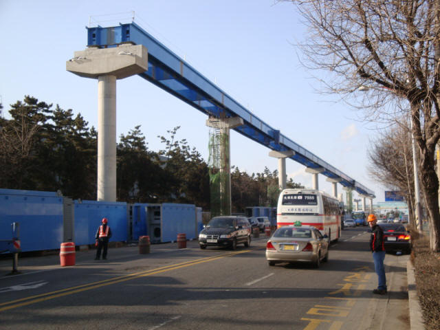
This could work:

It's built tall because "the guideway crosses a freeway at 20 meter (66ft) height with adjacent sections having 6 to 7° grades."

Last edited by Franky; Apr 18, 2009 at 9:39 PM.
Reply With Quote
     
     
  #3797  
Old Posted Apr 18, 2009, 9:51 PM
Aylmer's Avatar
Aylmer Aylmer is offline
 
Join Date: Nov 2007
Posts: 5,407
Quote:
Originally Posted by Franky View Post
You're just kidding, right.

This could work:

It's built tall because "the guideway crosses a freeway at 20 meter (66ft) height with adjacent sections having 6 to 7° grades."
Oh, I think that people in Ottawa can deal with not stepping in front of trains.
Elevated tracks are for dumb people and the senile.

Reply With Quote
     
     
  #3798  
Old Posted Apr 19, 2009, 2:31 AM
Franky's Avatar
Franky Franky is offline
 
Join Date: Apr 2008
Posts: 1,551
Quote:
Originally Posted by AylmerOptimist View Post
Oh, I think that people in Ottawa can deal with not stepping in front of trains.
Elevated tracks are for dumb people and the senile.

What are you talking about? We have tons of "dumb people and the senile", we also have protesters and children. An elevated system means it can be automated, fast, safe and reliable. Surface LRT is neither.
Reply With Quote
     
     
  #3799  
Old Posted Apr 19, 2009, 3:35 PM
Aylmer's Avatar
Aylmer Aylmer is offline
 
Join Date: Nov 2007
Posts: 5,407
Quote:
Originally Posted by Franky View Post
What are you talking about? We have tons of "dumb people and the senile", we also have protesters and children. An elevated system means it can be automated, fast, safe and reliable. Surface LRT is neither.
But in Europe, children don't fling themselves in front of oncoming trains and protesters don't walk in front of them either.

It isn't rocket science; Lie down on the tracks and, within the headway time, you will most certainly perish. Oh, sure, someone might have the brains to do so, but it is something that people get used to, just like cars on the road.

I am convinced that most people on this forum have the education to not jump in front of fast-moving vehicles and Ottawa is one of the most educated cities in North America, so I think we can handle Trams.

Reply With Quote
     
     
  #3800  
Old Posted Apr 19, 2009, 5:16 PM
kwoldtimer kwoldtimer is offline
 
Join Date: Jan 2008
Posts: 26,252
Quote:
Originally Posted by Franky View Post
What are you talking about? We have tons of "dumb people and the senile .....
Indeed, just look at city council!
Reply With Quote
     
     
This discussion thread continues

Use the page links to the lower-right to go to the next page for additional posts
 
 
Reply

Go Back   SkyscraperPage Forum > Regional Sections > Canada > Ontario > Ottawa-Gatineau > Transportation
Forum Jump


Forum Jump


All times are GMT. The time now is 5:57 AM.


Powered by vBulletin® Version 3.8.7
Copyright ©2000 - 2026, vBulletin Solutions, Inc.