HomeDiagramsDatabaseMapsForum About
     

Go Back   SkyscraperPage Forum > Global Projects & Construction > City Compilations


Closed Thread

 
Thread Tools Display Modes
     
     
  #4501  
Old Posted Jul 19, 2008, 5:48 AM
Evergrey's Avatar
Evergrey Evergrey is offline
Eurosceptic
 
Join Date: Apr 2003
Location: Pittsburgh
Posts: 24,141
I have a request: Does anybody on here have photos (or directions to photos) of Carson St. from say 1975-1995? (Grego? Urbani?) I've never seen the "pre-revitalized" business district and have always wondered what it was like (first time I ever visited was maybe 2003 or so). I walked the full length of Carson St. twice tonight... and was blown away at its vibrancy (as always). Tonight seemed like it may have been the most packed with people walking around and dining outside and enjoying themselves that I have ever seen. I was especially impressed with how vibrant and busy the district remained east of the Birmingham Bridge... which had long been a bit weaker than the heart of the district. The stretch between Birmingham Bridge and SouthSide Works seems to be developing nicely. Hookah Bookah was overflowing onto the sidewalk with an interesting and diverse clientele. Double Wide Grille was bursting at the seems with people noshing on their succulent late night barbecue. Etc.


....


more info on the Poli project

http://www.post-gazette.com/pg/08201/898080-53.stm

$50 million Poli project will reshape Squirrel Hill

Saturday, July 19, 2008
By Steve Levin and Diana Nelson Jones, Pittsburgh Post-Gazette


Darrell Sapp/Post-Gazette
A developer envisions a nine-story project == featuring a hotel, condos, a restaurant and retailers == at Murray and Forward avenues in Squirrel Hill.


Individually, the construction of a hotel, condominiums, an upscale restaurant and retail stores in Squirrel Hill would be a boon to its present small business mix.

But proposed together as a $50 million residential/retail mix at the site of the former Poli restaurant, the project not only would dramatically remake the Squirrel Hill entrance from the Parkway East but become the largest development project in the neighborhood's history.

Called Forward Square, the development by R.E. Crawford and Cambridge Venture Partners is proposed on a 150,000-square-foot site at Murray and Forward avenues. The nine-story project would include a six-story hotel, 20 condos on the three other floors, a restaurant similar to Sonoma Grill, several retailers and a two-story water plaza.

Sales agreements have been reached both for the former Poli property on Murray Avenue, including its two parking lots on lower Forward, and with Alderson-Forward Properties, which owns an adjacent building at 5800 Forward now housing five businesses, including the six-screen Squirrel Hill Theater.

Plans for the project were filed this week with the Zoning Board of Adjustment. A zoning board public hearing on the project is scheduled for Aug. 7.

City Council President Doug Shields said the project is "a dynamic development in a part of Squirrel Hill that has not seen any recent investment.

"Reaction, so far, has been positive," he said. "From what I can see, it's a good design."

Steven Hawkins, president of the Squirrel Hill Urban Coalition, said a community meeting with the project's developers is set for Aug. 4 at 7 p.m. at the Jewish Community Center.

The Forward Square condos are expected to be priced at less than $350,000 each and vary in size from 700 to 1,400 square feet, said Tom Chunchick, executive vice president of R.E. Crawford. The restaurant, he said, would go in the former Poli space. He said the company already is working with an operator to run the hotel.

Plans call for the entire development to be environmentally friendly, he said.

R.E. Crawford, run by 49-year-old Bob Crawford, is a rapidly growing general contractor based in Springdale Borough, with billings expected to be $75 million this year, up from $55 million in 2007.

Cambridge Venture Partners are Mr. Crawford; Steve Davis, vice president of Pennsylvania Commercial Real Estate; and real estate attorney Russell P. Mills, of Mills & Henry.

Cambridge has been involved in student housing projects throughout the mid-Atlantic region, including 38 condominiums at Virginia Tech University in Blacksburg, Va., 406 condos and apartments at West Virginia University and other projects in Harrisonburg, Va., and Blairsville, Indiana County.

R.E. Crawford's projects around the country run the gamut from strip shopping centers and restaurants to churches and health care buildings. Local projects have included the two Rivertech buildings on the South Side near the UPMC Sports Performance Complex and an ongoing hotel project on Forbes Avenue.

Mr. Chunchick said the Forward Square project is a continuation of Mr. Crawford's "great passion for this city."

"This will be just a dynamic portal to this part of Squirrel Hill," Mr. Chunchick said, "and a great catalyst" for further development.

Poli restaurant, a Pittsburgh institution since 1921, has been closed since December 2005. In March 2007 it filed for Chapter 11 bankruptcy protection.

The two-story, 16,500-square-foot building and a small parking lot across the street were listed together at a price of $1.3 million. A separate 1.4-acre parcel nearby that Poli used for valet parking was valued at $800,000.

The 17,505-square-foot property at 5800 Forward was last sold in 2000 for more than $3.5 million, according to Allegheny County records.

Mr. Chunchick said the Poli property was purchased about six months ago and the other parcel within the past few weeks. He said he did not know the sale price for the properties.

In addition to the theater, other businesses to be razed are Pizza Amier, the Tango Cafe, the Gay and Lesbian Community Center and U.S. Professional Karate. Unaffected are Forward Lanes and other businesses farther south on Forward and the Howard Levin Clubhouse and other properties that are part of the Morrowfield Apartments building west on Murray.

The karate school's owners, Vicki and George Mowod, have already secured a new site -- at 2345 Murray Ave. in a building that houses a Starbucks -- but its visibility to five directions of traffic for the past 25 years is hard to match.

"The sad part is we lose that," Ms. Mowod said. "We need 25 more students to move into that building, so now I have to do marketing without my windows, and that's a big expense."

Liliana Petruy, owner of Tango Cafe, said she renewed a one-year lease for her restaurant last month.

Business had been good with the theater nearby, she said.

"I really don't know where we will go."

Steve Levin can be reached at [email protected] or 412-263-1919. Diana Nelson Jones can be reached at [email protected] or 412-263-1626.


....


Here's that Rivertech development that this company did

Last edited by Evergrey; Jul 19, 2008 at 7:13 AM.
     
     
  #4502  
Old Posted Jul 19, 2008, 6:29 AM
JackStraw JackStraw is offline
BANNED
 
Join Date: Jun 2007
Posts: 2,799
Holy shit, this is going to take shape!

I live two blocks away. Lets hope this is not a lame strip mall shop in Squirrel Hill. I don't want to see the typical shit that I see in Wexford or Moronville. That is what make Squirrel Hill different then those places.

Also, if this Hotel exist, lets let it give new and bright life to PD's pub. God that bar needs it...........
     
     
  #4503  
Old Posted Jul 19, 2008, 6:48 AM
Evergrey's Avatar
Evergrey Evergrey is offline
Eurosceptic
 
Join Date: Apr 2003
Location: Pittsburgh
Posts: 24,141
hey... we finally found a use for the former LTV site in Hazelwood: dirt depository!

I was thinking about our region's topography and in particular this site the other day... this is an incredibly hilly region and there are very few significant areas of truly flat land ... they usually only occur at bends in the rivers where sediment has been deposited over the years (convex banks). Going upstream on the Monongahela from the Point, the first example of this geographic phenomenon is the South Side vs. Bluff/Uptown. The South Side represents the convex bank where sediment has been deposited due to the trajectory of the river bend, resulting in a long flat area perfect for high-density urban development with potential for riverfront interface (an ongoing process as this was the realm of heavy industry before). Across the river, Bluff/Uptown represents the concave bank. Due to the highly dissected nature of our hydrography and topography in Southwestern Pennsylvania, the northern bank at this point almost immediately rises sharply from the river several hundred feet to Uptown (and Duquesne U.) high above the river. The flat river interface is only wide enough to support the Parkway East and the narrow string of buildings at the Tech Park. While Uptown and Oakland are technically adjacent to the river, the sharp elevation difference eliminates their interface with it.

Just to the east of the Hot Metal Bridge, the Mon begins to meander the opposite direction, and the convex and concave banks reverse. Past the SouthSide Works, the flat plain of the South Side narrows quickly. Carson St. between SSW and Homestead (it is known as Eighth St. there) is virtually undeveloped as there is barely enough flat land along the river for the road itself. The bluff rises sharply near the river's edge to the undeveloped Hay's Woods high above. Across the river from this empty stretch is Hazelwood and the large flat emptiness of the former LTV site. This site, on a flat riverfront site not far from Downtown, Oakland and South Side holds great potential for high-density urban development IMO. It also has a great view of the Downtown skyline. There have been a couple mentions of development there in recent years (Carnegie Mellon's mysterious proposed "Robot City" as well as a proposal for housing/office mix), but I believe the grim spectre of the potential Mon Fayette Expressway blasting its way through this prime parcel has left the future of this site in limbo... left to do nothing more than collect dirt (literally).

The LTV site would be the perfect site for high-density residential development, perhaps even a mid-rise scale. There would be minimal NIMBY resistance due to its relative isolation (even from the rest of Hazelwood). It could really promote smart, urban living. It would be very easy to bike to work from there... a couple minutes and a biker can cross the pedestrian Hot Metal Bridge to the South Side, or connect to the Eliza Furnace Trail and head downtown.

Developing this convex bank would be the perfect complement to all the riverfront residential development that has occurred in the South Side in recent years... extending the urban riverfront eastward even further. There's no room to extend the South Side any further east... allow it to jump the Hot Metal Bridge and take root at LTV.

...

http://www.pittsburghlive.com/x/pittsburghtrib/news/cityregion/s_578421.html

Former LTV site gets dirt from North Shore tunnel dig

By Terry McCoy
TRIBUNE-REVIEW
Saturday, July 19, 2008


Trumbull Construction's Richard Wingard moves dirt gathered during work on the North Shore Connector tunnel.
Andrew Russell/Tribune-Review

The 520 cubic yards of earth extracted each day from beneath the Allegheny River for the North Shore Connector is turning molehills into mountains at the former LTV Steel site in Hazelwood.

By the end of the tunnel project in 2011, which will extend the Port Authority's T light rail system to the North Shore, officials estimate nearly 70,000 cubic yards of dirt, clay and sand will be mined and hauled away.

That's enough dirt to fill Heinz Field 120 feet high.

Day by day, 25 dirt-laden dump trucks head out to the former LTV Steel plant, which closed in 1997.

"All I can say is it's a lot of dirt, quite a bit," said Port Authority spokesman Dave Whipkey. "To be completely honest, I have no idea what we're going to do with all that material."

About half of the extracted earth is a sand-gravel mixture, which Lindy Paving will use in projects, Whipkey said. Lindy Paving is owned by Trumbull Corp., the company overseeing the tunnel project.

But the rest of material -- a dense, reddish clay -- is virtually useless, so the city is sending it to languish at the LTV site.

"Basically, it's not being used for anything out there," Whipkey said. "There aren't any long-range plans with the clay material. The sand-gravel does have a use."

This material is all that's been found underneath the river, Whipkey said. No fossils, no buried treasure -- nothing but dirt.

At the LTV site along the Mononghela River, a desert scene unfolds: 20-foot dunes bake under a beating sun, heat waves waft above. Off to one side, a pool of sludge fresh from the tunnel belches.

Because the material hasn't seen daylight in thousands of years and is unpolluted, the environmental impact of unloading the dirt is minimal, Whipkey said.

"Yeah, it's not a whole lot to look at," said Bill Widdoes, the project coordinator for the Regional Industrial Development Corp., which owns the LTV Steel site. "Just a lot of dirt."
     
     
  #4504  
Old Posted Jul 19, 2008, 8:56 AM
Dr Nevergold Dr Nevergold is offline
Registered User
 
Join Date: Jun 2000
Location: Winnipeg
Posts: 19,889
Before reading what LTV meant, I thought it was some bizzaire acronym like for a Lesbian and Transgender Village.

Sounds like a good plan for redevelopment, hopefully they can create a better transportation system between Homestead and South Side, that old highway just doesn't make most of some fairly prime land.
     
     
  #4505  
Old Posted Jul 19, 2008, 1:39 PM
Grego43's Avatar
Grego43 Grego43 is offline
Registered User
 
Join Date: Apr 2006
Posts: 766
Quote:
Originally Posted by Evergrey View Post
I have a request: Does anybody on here have photos (or directions to photos) of Carson St. from say 1975-1995? (Grego? Urbani?) I've never seen the "pre-revitalized" business district and have always wondered what it was like (first time I ever visited was maybe 2003 or so). I walked the full length of Carson St. twice tonight... and was blown away at its vibrancy (as always).
I don't have any in my possession, but I'll bet sites such as Heinz History Cnt., http://www.pghhistory.org/ or the historical society would. I can tell you from memory, (yes at 45 I can still remember that far back) that up until the mid-80s Carson St. was like the commercial strip in any other blue collar Pgh neighborhood. Lots of bars to serve the Mill Hunks who worked at LTV & J & L steel mills. It was vibrant, but not it the way it is today. It was dirty...just imagine factories stretching from the South Side Works for miles upstream.

A bit of trivia for those who wonder why the Birmingham bridge seems so out of scale to the intimate Carson St: It was a component of the planned Oakland/Crosstown Freeway.
     
     
  #4506  
Old Posted Jul 19, 2008, 1:51 PM
Austinlee's Avatar
Austinlee Austinlee is offline
Chillin' in The Burgh
 
Join Date: Nov 2004
Location: Spring Hill, Pittsburgh
Posts: 12,488
Brandon, would you like to come live in the Lesbian & Transgender Village I am starting in Pittsburgh?
     
     
  #4507  
Old Posted Jul 19, 2008, 3:58 PM
Dr Nevergold Dr Nevergold is offline
Registered User
 
Join Date: Jun 2000
Location: Winnipeg
Posts: 19,889
I'm gay, not lesbian nor transgender. BUT, I'll visit!
     
     
  #4508  
Old Posted Jul 19, 2008, 4:07 PM
Dr Nevergold Dr Nevergold is offline
Registered User
 
Join Date: Jun 2000
Location: Winnipeg
Posts: 19,889
BTW, in regards to the Birmingham Bridge, it happens to be a very funky interchange on the north shore of the Monongahela (did I spell that right?).

Pittsburgh does need a slightly modernized roadway system, but I'm not sure tearing through the heart of Oakland is the right method... I could see expanding the west parkway, maybe digging dual tunnel extensions for the Ft Pitt Tunnel to expand the Parkway West to 8 or 10 lanes from downtown all the way through Robinson Twp and to the airport and possibly doing the same for 279 north all the way to Cranberry as a possible highway expansion that makes sense.

Instead of building highways, they should consider upgrading the roadways near the river systems to wider parkways maybe with tree-lined medians and bike lanes and developed walkways beside the river itself to take advantage of the waterfront locations.

And of course build a center city circulator subway/LRT extension as proposed in another section.
     
     
  #4509  
Old Posted Jul 19, 2008, 4:10 PM
Gilamonster Gilamonster is offline
Registered User
 
Join Date: Dec 2007
Location: Pittsburgh
Posts: 463
Quote:
Originally Posted by BrandonTO416 View Post
I'm gay, not lesbian nor transgender. BUT, I'll visit!
Not that there's anything wrong with that......
__________________
An optimist and a pessimist have one common viewpoint; their dislike of a realist.
     
     
  #4510  
Old Posted Jul 19, 2008, 6:21 PM
themaguffin themaguffin is offline
Registered User
 
Join Date: Mar 2005
Posts: 2,311
Quote:
I have a request: Does anybody on here have photos (or directions to photos) of Carson St. from say 1975-1995? (Grego? Urbani?) I've never seen the "pre-revitalized" business district and have always wondered what it was like (first time I ever visited was maybe 2003 or so). I walked the full length of Carson St. twice tonight... and was blown away at its vibrancy (as always). Tonight seemed like it may have been the most packed with people walking around and dining outside and enjoying themselves that I have ever seen. I was especially impressed with how vibrant and busy the district remained east of the Birmingham Bridge... which had long been a bit weaker than the heart of the district. The stretch between Birmingham Bridge and SouthSide Works seems to be developing nicely. Hookah Bookah was overflowing onto the sidewalk with an interesting and diverse clientele. Double Wide Grille was bursting at the seems with people noshing on their succulent late night barbecue. Etc.
I can tell from my first days there as a Duquesne student (Southside was our Oakland essentially) as far back as '93 (sounds weird saying far back) it was pretty vibrant. From what I remember reading then, the beginning of the change from blue collar neighborhood began in the mid 80's with Mario's.

Of course this is also when steel was at peak collapse or ending so maybe with the people moving out, a natural change was destined to happen.

some other bars though, like Dee's and Jack's seem like they have been there forever (and were very very much still blue collar crowds, though had a mix of students and others too), but again, the area closer to 10th st seems less change then further down the road.. It was evolving then though it seemed a little less lively in the late 90's, which I had thought was due to the Strip peaking in clubs etc.

what's great is that the Southside continues to improve (and good things are happening in the Strip too).

My only complaint is a small one (sort of), the god awful Cheesecake Factory which I have commented on before and I suppose it's very appropriate that "cheese" would be in their name...
     
     
  #4511  
Old Posted Jul 19, 2008, 10:52 PM
Austinlee's Avatar
Austinlee Austinlee is offline
Chillin' in The Burgh
 
Join Date: Nov 2004
Location: Spring Hill, Pittsburgh
Posts: 12,488
I took these photos yesterday while driving through Cranberry. I think it is the new Westinghouse complex. Can anyone confirm this?


  #4512  
Old Posted Jul 20, 2008, 3:04 AM
UrbaniDesDev's Avatar
UrbaniDesDev UrbaniDesDev is offline
Walkable CITIES!
 
Join Date: Mar 2006
Location: Fort Lauderdale
Posts: 422
I will search for some photos of "Old Carson Street" I have none at the moment. It actually wasn't, physically that different. Just very different people living there and business that supported them.

I've always believed the site East of the Hot Metal Bridge would be a magnificent place for a dense, urban riverfront neighborhood, complete with a commercial spine. As I understand it, to be a residential area it is too polluted. Commercial districts have less stringent codes for clean up. The ground is saturated with chemicals and, I've heard, has been deemed uncompatable for residential district...
or it would be hugely expensive to clean up. This is what I've heard.
__________________
We live in a Throw away society........
     
     
  #4513  
Old Posted Jul 20, 2008, 3:17 AM
UrbaniDesDev's Avatar
UrbaniDesDev UrbaniDesDev is offline
Walkable CITIES!
 
Join Date: Mar 2006
Location: Fort Lauderdale
Posts: 422
looking through the web I cam across this site about the Hays "forest"


What is Hays Woods?
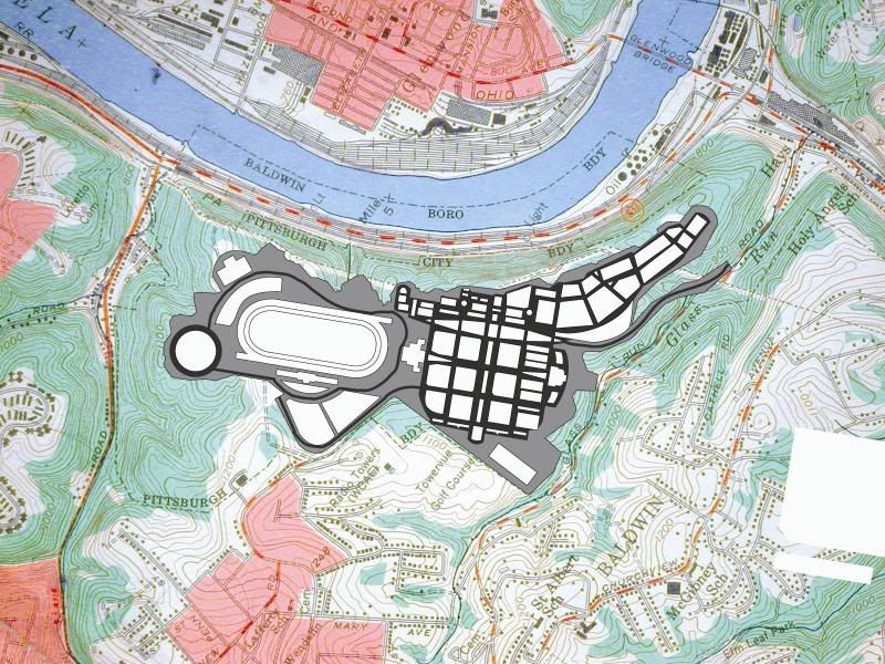
Hays Woods is a 635+ acre woodland on a hilltop overlooking the Monongahela River. This is the largest undeveloped tract of land in the City of Pittsburgh. It is located between the community of Hays and Becks Run Road, within 3 miles of the downtown area. It is larger than Frick Park, the largest of the city parks. The site contains more than 250 acres of mature interior hardwood forest patches, which support diverse communities of plants, birds and wildlife. Hays Woods has served as a de-facto recreational green space for the residents of the surrounding communities for more than 40 years. A network of trails has developed to support hiking, bird watching, trail biking, cross country skiing, hunting and more.

The forest is privately owned by Pittsburgh Development Group II who propose to develop Hays Woods as a horse-race track, retail and residential complex. Prior to construction, the forest will be logged and the underlying coal seams will be removed using mountaintop removal coal mining methods. To level the site for development, the overburden from the mining will be used to fill in 3 wetlands and 5 of the six streams.

Development Status
Hays Woods is privately owned by Pittsburgh Development Group II who proposes to develop the forest as a horse racetrack, retail and residential complex. Before development can begin, PDG II must receive permits from governmental agencies.

Federal

The developer seeks a permit to fill wetlands and streams. The federal Army Corps of Engineers cannot issue its permit until and unless a surface mining permit and the required state stream obstruction permit are granted by the Pennsylvania Department of Environmental Protection.
State

The Dept. of Environmental Protection is currently considering the developer's surface mining and stream obstruction permit application. The developer has received several deficiency notifications about the appliccation and the deadlines for his response have been extended.
The developer has not been granted the Pennsylvania Horse Racing Commission License.
The developer has withdrawn his casion application.
County

The Allegheny County Conservation District issued the developer violations of the Pennsylvania's Clean Streams Law for erosion and sedimentation control problems on an access road to the site.
The Allegheny County Health Department issued an air permit for the mining operation on the site
City

The City of Pittsburgh granted a conditional use approval for excavation/grading/fill in 2003.
The City of Pittsburgh approved rezoning of the site to Special Planned District in 2003. Pittsburgh's Planning Commission has not yet approved the final development plan. The Commission must review a traffic impact analysis, which has not been conducted, before approving the development plan.
The City of Pittsburgh is awaiting submission of a traffic plan by the developer.

Impact of Mining and Development
Prior to 1930, extensive room and pillar underground coal mining took place in Hays Woods. Pittsburgh Development Group (PDG) II plans to remove all remaining coal using Mountain Top Removal strip mining before construction begins.

In PDG's plan, the site's forests, containing mature stands of oak, poplar, maple, cherry, walnut and other trees will be logged, resulting in loss of habitat and displacement of resident wildlife. As this island of forest in the urban landscape is destroyed, large numbers of wildlife will flee to adjacent neighborhoods.


example of a logging operation

After the forest is logged, overlaying rock strata will be blasted away to expose the coal seam. This blasting will occur within 1/2 mile of surrounding homes. The airborne particulates produced by blasting may create a serious health hazard, which will affect the communities of Baldwin, Hazelwood and Hays.

More than 13 million cubic yards of earth will be moved. The hills will be excavated to depths up to 200 feet and the excavated overburden will be used to fill in the stream valleys to produce a flat landscape for development. These valley fills will bury 3 wetlands and 6 streams. These watersheds, and their forests, mitigate storm run off into adjacent watersheds, which are prone to flooding.

This mining activity will reduce the overall elevation of the site by 90 feet. As much as 1,200,00 tons of coal could be removed from Hays Woods over an 18-month period, requiring some 60,000 truck trips along Glass Run Road and Carson Street to the Hot Metal Bridge and Parkway. Because of recent major commercial developments in the neighboring communities of Homestead and South Side, these routes are already overburdened with traffic. To date, PDF II has not submitted a traffic analysis to the City of Pittsburgh.

It is unprecedented that Mountain Top Removal methods of coal mining will be used in an urban setting.


http://www.savehayswoods.org/index.html

It is mostly from 2003 but there doesn't seem to have been any conclusion yet. The silence on a conclusion of such a massive project is suspicious...
__________________
We live in a Throw away society........
     
     
  #4514  
Old Posted Jul 20, 2008, 4:09 AM
UrbaniDesDev's Avatar
UrbaniDesDev UrbaniDesDev is offline
Walkable CITIES!
 
Join Date: Mar 2006
Location: Fort Lauderdale
Posts: 422
OK
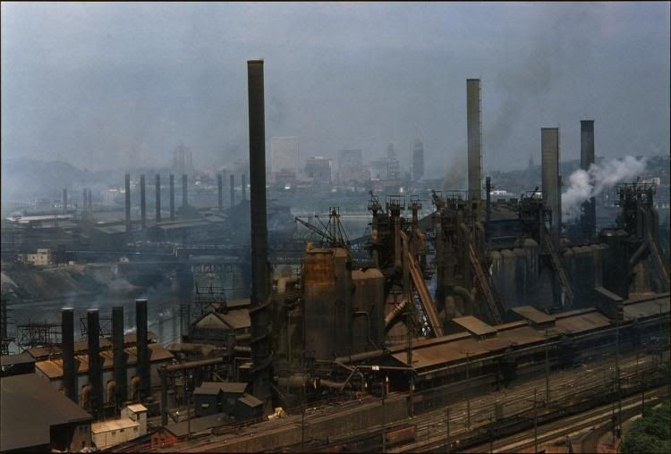
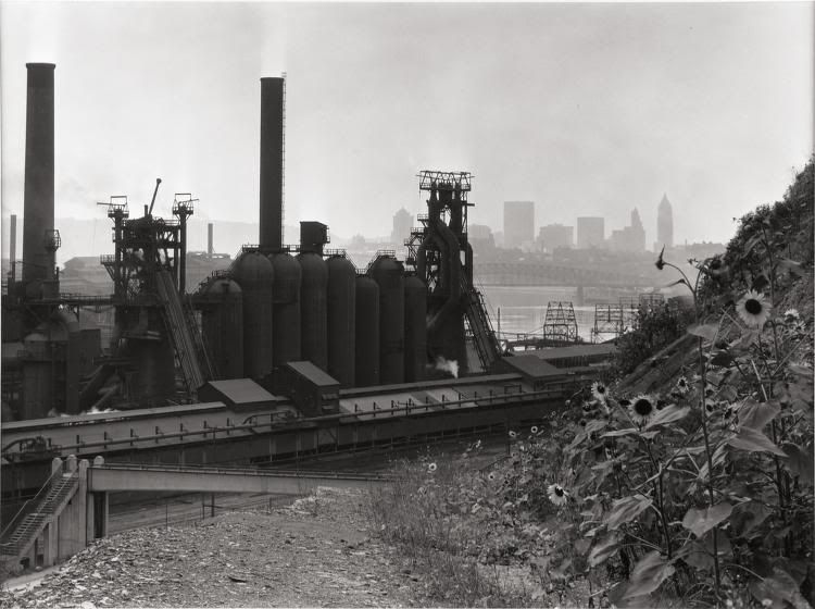
I found some historic pics that might astound you!

The South Side Works;

Description: Jones & Laughlin Steel Corporation's South Side Works and the Brady Street Bridge as seen from an asphalt business near Second Avenue. The Brady Street Bridge, or the South Twenty-Second Street Bridge, opened to traffic in March 1896 and was demolished on May 29, 1978. Note the dump trucks in the center of the photograph waiting in line to be loaded.
Subjects: Jones & Laughlin Steel Corporation.South Side Works.
The Brady Street Bridge is where the Burmingham Bridge is now. Note the same type of dredging structures still in the same place.
The South Side Works across the river!


Title: Bank of Open-hearth Furnaces under Construction on Carson Street at the South Side Plant of the Jones & Laughlin Pittsburgh Works
Date: 1953
Creator: Hare, Clyde
Description: Construction of open-hearth furnaces at the Jones & Laughlin Steel Corporation's South Side Works on Carson Street looking toward Pittsburgh's Soho neighborhood.
Subjects: Jones & Laughlin Steel Corporation.South Side Works.


Title: Jones & Laughlin Steel Mill in Daylight
Date: c. 1951
Creator: Milmoe, James O.
Description: Jones & Laughlin Steel Corporation's Soho Works (foreground) with its South Side Works on the left, and downtown Pittsburgh in the background. The Soho Works, employing over 5000 people at one time, closed in 1977 and its blast furnaces were demolished in the mid-1980s.


Description: Night view of the Jones & Laughlin Steel Corporation's Soho Works looking toward downtown Pittsburgh. The tall building under construction in the background is the Gulf Building. The building is forty-four stories (582 feet) in height and was the tallest building in Pittsburgh until 1970. The Gulf Building, built at a cost of $11 million, officially opened in 1932.

Note THE HOT METAL BRIDGE, silhouetted, connecting the massive factories that lined both sides of the Mon. It carried molten steel from one side to the other
Thus "HOT METAL"


Date: 1952
Creator: Corsini, Harold
Description: View of Pittsburgh's Soho section from the Boulevard of the Allies looking toward the South Side. Pictured in the foreground is Forbes Avenue along with the Monongahela River in the background.


to this...Now the South Side Works & The Technology Center


The TRUE Technology Center!!!
Construction of the Parkway East


Bates Street in foreground. Note the same bridge used today under RR tracks


The Homestead Waterfront


Note the remaining smoke stacks in foreground


The UPS/Kinkos store on Carson


I realise these aren't what you were looking for, but I got caught up in the photos.
It is important to realise how far we have come.
__________________
We live in a Throw away society........

Last edited by UrbaniDesDev; Jul 20, 2008 at 5:21 AM.
     
     
  #4515  
Old Posted Jul 20, 2008, 4:14 AM
Austinlee's Avatar
Austinlee Austinlee is offline
Chillin' in The Burgh
 
Join Date: Nov 2004
Location: Spring Hill, Pittsburgh
Posts: 12,488
Man, those steel mills were humongous. Each one was like their own little industrial city.
     
     
  #4516  
Old Posted Jul 20, 2008, 4:58 AM
Burgh15's Avatar
Burgh15 Burgh15 is offline
Registered User
 
Join Date: May 2008
Location: Pittsburgh
Posts: 158
     
     
  #4517  
Old Posted Jul 20, 2008, 10:57 AM
Johnland Johnland is offline
Registered User
 
Join Date: May 2007
Posts: 763
Quote:
Originally Posted by UrbaniDesDev View Post
looking through the web I cam across this site about the Hays "forest"


What is Hays Woods?
Hays Woods is a 635+ acre woodland on a hilltop overlooking the Monongahela River. This is the largest undeveloped tract of land in the City of Pittsburgh. It is located between the community of Hays and Becks Run Road, within 3 miles of the downtown area. It is larger than Frick Park, the largest of the city parks. The site contains more than 250 acres of mature interior hardwood forest patches, which support diverse communities of plants, birds and wildlife. Hays Woods has served as a de-facto recreational green space for the residents of the surrounding communities for more than 40 years. A network of trails has developed to support hiking, bird watching, trail biking, cross country skiing, hunting and more.

The forest is privately owned by Pittsburgh Development Group II who propose to develop Hays Woods as a horse-race track, retail and residential complex. Prior to construction, the forest will be logged and the underlying coal seams will be removed using mountaintop removal coal mining methods. To level the site for development, the overburden from the mining will be used to fill in 3 wetlands and 5 of the six streams.
I'm aghast that the city ok'd a plan to destroy a remaining woodlands and wetlands at all. But for the sake of some racetrack is appalling. Hopefully the whole project will die and never happen.
     
     
  #4518  
Old Posted Jul 20, 2008, 1:47 PM
hyperion1110's Avatar
hyperion1110 hyperion1110 is offline
Atop Washington's Mount
 
Join Date: Jan 2007
Location: Pittsburgh
Posts: 354
I agree about the destruction of the forest for a race track. I mean, isn't there enough gambling in the area??? Hopefully, this project is forever stalled, since the Pittsburgh gambling market (if you consider the West Virginia panhandle, as well) has GOT to be saturated!

What I would like to see is the city make about 450 acres protected land (though not a city park...I think it should be kept as forest). The remaining 200 acres, that to the west, adjacent to the surrounding neighborhoods, be given over to some sort of high density development. My preference would be for it to be heavily residential. I mean, think about it. How many places can offer urban living on one side, and a giant forest on the other??? But, I reinterate, the remaining forest should be kept forest, and given some kind of protected status, so it doesn't just become another city park.

UrbaniDesDev, those pictures are truly incredible. Thanks for sharing!
     
     
  #4519  
Old Posted Jul 20, 2008, 1:52 PM
Austinlee's Avatar
Austinlee Austinlee is offline
Chillin' in The Burgh
 
Join Date: Nov 2004
Location: Spring Hill, Pittsburgh
Posts: 12,488
Anyone wanna see my pictures from the Pgh Vintage Grand Prix this weekend? I just made a photothread:

http://forum.skyscraperpage.com/showthread.php?t=154618
     
     
  #4520  
Old Posted Jul 20, 2008, 5:06 PM
Evergrey's Avatar
Evergrey Evergrey is offline
Eurosceptic
 
Join Date: Apr 2003
Location: Pittsburgh
Posts: 24,141
that Hays racetrack plan died a couple years ago
     
     
This discussion thread continues

Use the page links to the lower-right to go to the next page for additional posts
 
 
Closed Thread

Go Back   SkyscraperPage Forum > Global Projects & Construction > City Compilations
Forum Jump


Forum Jump


All times are GMT. The time now is 1:19 PM.


Powered by vBulletin® Version 3.8.7
Copyright ©2000 - 2026, vBulletin Solutions, Inc.