HomeDiagramsDatabaseMapsForum About
     

Go Back   SkyscraperPage Forum > Regional Sections > Canada > Ontario > Ottawa-Gatineau > General Discussion


Reply

 
Thread Tools Display Modes
     
     
  #341  
Old Posted May 15, 2025, 4:31 PM
Hybrid247 Hybrid247 is offline
Registered User
 
Join Date: Oct 2009
Posts: 1,320
It looks like Google Maps is now showing satellite imagery from Summer 2024. This must've been updated very recently because much of the Stage 2 LRT progress appeared to be from 2022 just the other day.
Reply With Quote
     
     
  #342  
Old Posted Jul 15, 2025, 5:46 AM
rocketphish's Avatar
rocketphish rocketphish is offline
Planet Ottawa and beyond
 
Join Date: Feb 2009
Location: Greater Ottawa
Posts: 14,619
Seen this car around Ottawa? It's not Google Street View. It's the GATSmobile

CBC News
July 14, 2025


The City of Ottawa has a new tool to measure and map out the city's roadways, intended to make city planning and design easier. CBC's Robyn Miller rides along with the city's Geospatial Analytics, Technology and Solutions (GATS) branch.

VIDEO: https://www.cbc.ca/player/play/video/9.6828946
Reply With Quote
     
     
  #343  
Old Posted Aug 2, 2025, 8:20 PM
Richard Eade Richard Eade is offline
Registered User
 
Join Date: Mar 2008
Location: Nepean
Posts: 2,637
I was looking to see what land the city needed to acquire for the Baseline-Greenbank intersection rebuild. In geoOttawa, I selected the layer Property Parcels and, under that, selected City Owned Lands. This highlighted all of the city-owned lands in blue (the default colour). It does not colour in road allowances, so any areas beside the road that were previously acquired as an expansion of the road allowance don’t get highlighted.

I was a bit surprised to see the homes along the south of Baseline that have been acquired by the city, presumably for this project. I suspect that the land was bought so that slivers can be taken off; then the remaining land will be resold.

City owned land around the Baseline-Greenbank intersection:
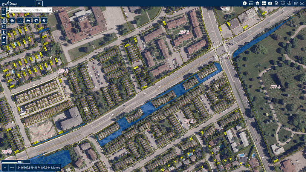


The land acquired from Pinecrest Cemetery had to taped to the east because it could not go any further due to occupied burial plots. It will be interesting to see what happens when – IF – the western half of the Baseline BRT is built.

I also scanned around to other areas. Check out what the city owns downtown:
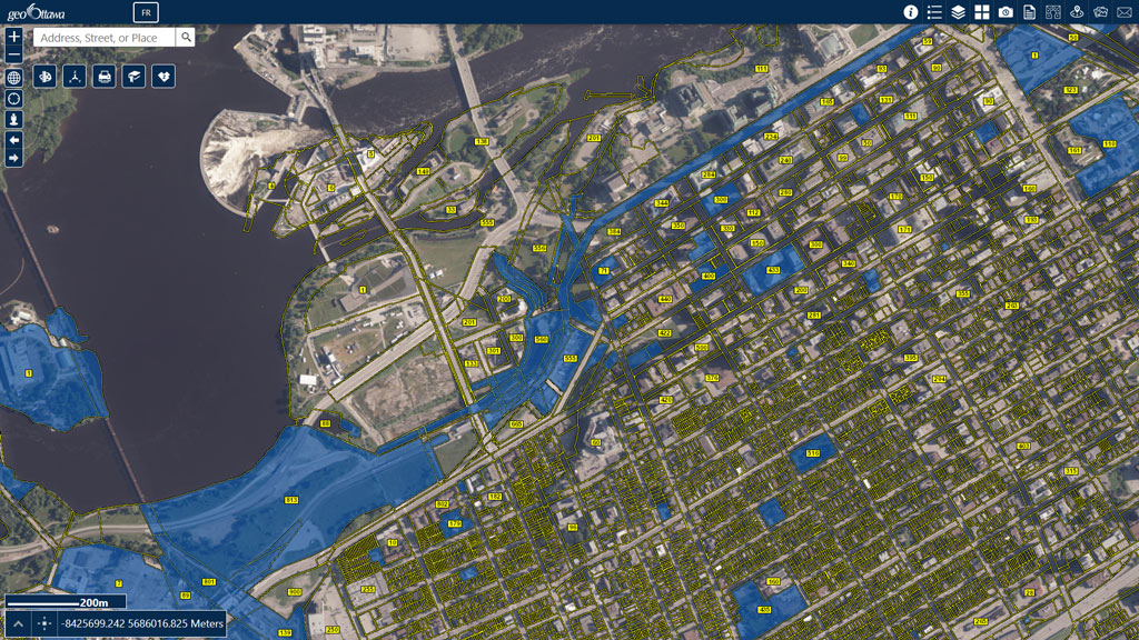


It looks as if the city owns most of the land fronting on Albert through LeBreton Flats. Also, Wellington, in front of Parliament Hill is being shown as city owned land – and NOT as a road allowance (which are not coloured).

Surprisingly, it is also showing the land that the NAC is built on as being owned by the city.

Reply With Quote
     
     
  #344  
Old Posted Aug 3, 2025, 4:26 AM
lrt's friend lrt's friend is offline
Registered User
 
Join Date: Dec 2006
Posts: 12,792
Quote:
Originally Posted by Richard Eade View Post
I was looking to see what land the city needed to acquire for the Baseline-Greenbank intersection rebuild. In geoOttawa, I selected the layer Property Parcels and, under that, selected City Owned Lands. This highlighted all of the city-owned lands in blue (the default colour). It does not colour in road allowances, so any areas beside the road that were previously acquired as an expansion of the road allowance don’t get highlighted.

I was a bit surprised to see the homes along the south of Baseline that have been acquired by the city, presumably for this project. I suspect that the land was bought so that slivers can be taken off; then the remaining land will be resold.

City owned land around the Baseline-Greenbank intersection:


The land acquired from Pinecrest Cemetery had to taped to the east because it could not go any further due to occupied burial plots. It will be interesting to see what happens when – IF – the western half of the Baseline BRT is built.

I also scanned around to other areas. Check out what the city owns downtown:


It looks as if the city owns most of the land fronting on Albert through LeBreton Flats. Also, Wellington, in front of Parliament Hill is being shown as city owned land – and NOT as a road allowance (which are not coloured).

Surprisingly, it is also showing the land that the NAC is built on as being owned by the city.

The NAC land was the site of Ottawa City Hall that burned down in 1931
Reply With Quote
     
     
  #345  
Old Posted Aug 3, 2025, 12:26 PM
J.OT13's Avatar
J.OT13 J.OT13 is offline
Moderator
 
Join Date: Mar 2012
Location: Ottawa
Posts: 28,916
Some very confusing stuff here. The NAC stands on the former site of City Hall and the Police Station, but surely there was some private ownership around there as well. And are we to believe the Feds built the NAC on City land? Is the NAC leasing the land from the City to this day?

Map also shows the City owning the old Zellers and attached office building. Obviously they had some sort of agreement with the developer to build the subway entrance, but I doubt they expropriated the entire land under them. Same with PdV II (minus the Marriott) or Claridge Moon/Skye. Also shows the City owning the Alterna site where Relevé and Marriott Renaissance ar/going up. I think the City considered buying part of that site for a subway entrance, but I don't think they went through with it. And Minto Place?

Tech Park, the City only owns the community gardens?

And then LeBreton, the Sens parcel is shown to be the City's. If that was the case, I'm sure Sutcliffe would have been far more disruptive to the arena talks.

I have some severe doubt that this is fully accurate.
Reply With Quote
     
     
  #346  
Old Posted Aug 5, 2025, 4:08 PM
Uhuniau Uhuniau is offline
Registered User
 
Join Date: Jan 2010
Posts: 9,067
Am I imagining things, or didn't there use to be a federal/NCC-owned lands layer?
__________________
___
Enjoy my taxes, Orleans (and Kanata?).
Reply With Quote
     
     
  #347  
Old Posted Aug 5, 2025, 4:10 PM
Uhuniau Uhuniau is offline
Registered User
 
Join Date: Jan 2010
Posts: 9,067
How does the city not own the land that the Lemieux Island water plant is on?
__________________
___
Enjoy my taxes, Orleans (and Kanata?).
Reply With Quote
     
     
  #348  
Old Posted Dec 5, 2025, 1:47 AM
rocketphish's Avatar
rocketphish rocketphish is offline
Planet Ottawa and beyond
 
Join Date: Feb 2009
Location: Greater Ottawa
Posts: 14,619
Well this is pretty cool!

https://app.shadowmap.org/?lat=45.39800&...ue&polar=0.52360&time=1764898540610&vq=2

Sit back, press the Play button, and watch the show
Reply With Quote
     
     
  #349  
Old Posted Dec 8, 2025, 2:30 PM
Norman Bates Norman Bates is offline
Living With My Mother
 
Join Date: Feb 2009
Posts: 1,027
Quote:
Originally Posted by rocketphish View Post
Well this is pretty cool!

https://app.shadowmap.org/?lat=45.39800&...ue&polar=0.52360&time=1764898540610&vq=2

Sit back, press the Play button, and watch the show
Unbelievably cool!
Reply With Quote
     
     
  #350  
Old Posted Dec 10, 2025, 3:15 PM
Uhuniau Uhuniau is offline
Registered User
 
Join Date: Jan 2010
Posts: 9,067
Don't tell the nimbies for god's sake
__________________
___
Enjoy my taxes, Orleans (and Kanata?).
Reply With Quote
     
     
  #351  
Old Posted Jan 23, 2026, 7:46 PM
urbanforest urbanforest is offline
Registered User
 
Join Date: Mar 2023
Posts: 326
Thanks to J.OT13 for pointing me to this thread; a few tools that I came across that may be of interest:

Smappen: You can use this to plot the population that lives within X travel time of a location (this is a paid tool but I was able to use the free demo multiple times by using it in a new private browsing window)

TravelTime is another one I found but it doesn't show population in the catchment area.
Reply With Quote
     
     
  #352  
Old Posted Jan 23, 2026, 7:51 PM
urbanforest urbanforest is offline
Registered User
 
Join Date: Mar 2023
Posts: 326
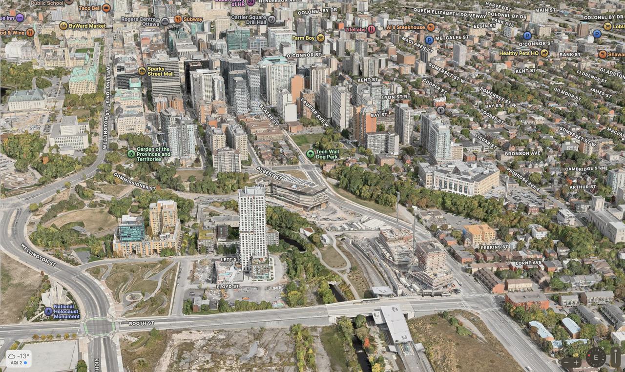
Apple Maps has rolled out new 3D imagery for Ottawa. It appears to be from this past fall, maybe September 2025. Previous imagery was late summer 2023.

Reply With Quote
     
     
  #353  
Old Posted Jan 23, 2026, 8:01 PM
J.OT13's Avatar
J.OT13 J.OT13 is offline
Moderator
 
Join Date: Mar 2012
Location: Ottawa
Posts: 28,916
That is much nicer than Google 3D. Do you need to be an Apple user/have an account to use access to Apple Maps?
Reply With Quote
     
     
  #354  
Old Posted Jan 23, 2026, 8:02 PM
J.OT13's Avatar
J.OT13 J.OT13 is offline
Moderator
 
Join Date: Mar 2012
Location: Ottawa
Posts: 28,916
Quote:
Originally Posted by urbanforest View Post
Thanks to J.OT13 for pointing me to this thread; a few tools that I came across that may be of interest:

Smappen: You can use this to plot the population that lives within X travel time of a location (this is a paid tool but I was able to use the free demo multiple times by using it in a new private browsing window)

TravelTime is another one I found but it doesn't show population in the catchment area.
Thanks!
Reply With Quote
     
     
  #355  
Old Posted Jan 23, 2026, 8:20 PM
rocketphish's Avatar
rocketphish rocketphish is offline
Planet Ottawa and beyond
 
Join Date: Feb 2009
Location: Greater Ottawa
Posts: 14,619
Note: I've merged the Census Data and Online Mapping Tool threads into a single thread.

Cool tools, BTW!
Reply With Quote
     
     
  #356  
Old Posted Jan 23, 2026, 8:47 PM
urbanforest urbanforest is offline
Registered User
 
Join Date: Mar 2023
Posts: 326
Quote:
Originally Posted by J.OT13 View Post
That is much nicer than Google 3D. Do you need to be an Apple user/have an account to use access to Apple Maps?
Unfortunately it seems you need an apple device to access the 3D imagery. Only a basic satellite image with streetview (and neat sidewalk/MUP-view) is available on the web/across platforms.
Reply With Quote
     
     
  #357  
Old Posted Aug 12, 2026, 4:23 PM
J.OT13's Avatar
J.OT13 J.OT13 is offline
Moderator
 
Join Date: Mar 2012
Location: Ottawa
Posts: 28,916
The 2025 satellite view has been added.
Reply With Quote
     
     
  #358  
Old Posted Aug 12, 2026, 4:51 PM
Uhuniau Uhuniau is offline
Registered User
 
Join Date: Jan 2010
Posts: 9,067
Quote:
Originally Posted by J.OT13 View Post
The 2025 satellite view has been added.
Oh, ok, it's fine, I didn't have anything else to do today anyway.
__________________
___
Enjoy my taxes, Orleans (and Kanata?).
Reply With Quote
     
     
  #359  
Old Posted Aug 12, 2026, 5:38 PM
dougvdh dougvdh is offline
Registered User
 
Join Date: Jun 2017
Posts: 360
Quote:
Originally Posted by Uhuniau View Post
Oh, ok, it's fine, I didn't have anything else to do today anyway.
Looks like they were taken around late March / early April 2025 by the progress of key projects such as the new apartments at Booth and Albert.
Reply With Quote
     
     
  #360  
Old Posted Aug 12, 2026, 5:53 PM
J.OT13's Avatar
J.OT13 J.OT13 is offline
Moderator
 
Join Date: Mar 2012
Location: Ottawa
Posts: 28,916
Quote:
Originally Posted by Uhuniau View Post
Oh, ok, it's fine, I didn't have anything else to do today anyway.
Reply With Quote
     
     
This discussion thread continues

Use the page links to the lower-right to go to the next page for additional posts
 
 
Reply

Go Back   SkyscraperPage Forum > Regional Sections > Canada > Ontario > Ottawa-Gatineau > General Discussion
Forum Jump


Forum Jump


All times are GMT. The time now is 8:21 AM.


Powered by vBulletin® Version 3.8.7
Copyright ©2000 - 2026, vBulletin Solutions, Inc.