HomeDiagramsDatabaseMapsForum About
     

Go Back   SkyscraperPage Forum > Regional Sections > Canada > Ontario > Ottawa-Gatineau > Urban, Urban Design & Heritage Issues


Reply

 
Thread Tools Display Modes
     
     
  #661  
Old Posted Mar 4, 2026, 6:12 PM
skyscraperaccount skyscraperaccount is offline
Registered User
 
Join Date: Jun 2023
Posts: 288
If the NCC is looking to add bike lanes adjacent to the current MUP, I hope to hell they or the city have the budget to maintain it in the winter for biking.
Reply With Quote
     
     
  #662  
Old Posted Apr 8, 2026, 12:22 PM
J.OT13's Avatar
J.OT13 J.OT13 is offline
Moderator
 
Join Date: Mar 2012
Location: Ottawa
Posts: 28,578
The NCC puts up the YouTube Link weeks in advance for their Board Meeting. It was up in late March for April 16, but has since been taken down. On the website, it says the next one is in June.

https://ncc-ccn.gc.ca/board-of-directors

Really hope that's not the case. I look forward to these every few months. It's my Christmas.
Reply With Quote
     
     
  #663  
Old Posted Jun 19, 2026, 2:44 PM
J.OT13's Avatar
J.OT13 J.OT13 is offline
Moderator
 
Join Date: Mar 2012
Location: Ottawa
Posts: 28,578
Board Meeting agenda is up. No LeBreton...

Highigths:

Gatineau Park Ecosystem Conservation Plan;
Confederation Heights Disposal of Seven Confederation Heights Properties;
Eastern Bridge Planning and Design Principles;
Centre Block Rehabilitation Project - 100% Landscape Developed Design;
The National Capital Core Area Plan Volume II;
Name recommendation for Kruger park: “Confluence Park /Parc de la Confluence”.

https://medias.ncc-ccn.ca/ncc/documents/bod-ju2026-public-agenda.pdf
Reply With Quote
     
     
  #664  
Old Posted Jun 24, 2026, 12:42 PM
J.OT13's Avatar
J.OT13 J.OT13 is offline
Moderator
 
Join Date: Mar 2012
Location: Ottawa
Posts: 28,578
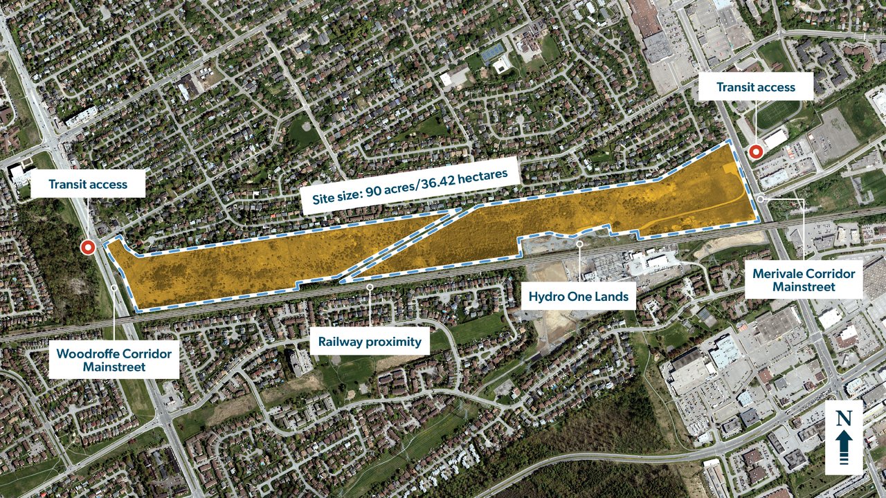
NCC looking for feedback on potential redevelopment of the "Southern Corridor".


http://ncc-ccn.gc.ca/business/southern-corridor
Reply With Quote
     
     
  #665  
Old Posted Jun 24, 2026, 12:50 PM
kwoldtimer kwoldtimer is offline
Registered User
 
Join Date: Jan 2008
Location: La vraie capitale
Posts: 26,143
What is the story behind such a large orphaned site?
Reply With Quote
     
     
  #666  
Old Posted Jun 24, 2026, 1:43 PM
J.OT13's Avatar
J.OT13 J.OT13 is offline
Moderator
 
Join Date: Mar 2012
Location: Ottawa
Posts: 28,578
Quote:
Originally Posted by kwoldtimer View Post
What is the story behind such a large orphaned site?
Even GeoOttawa doesn't really offer any clues. I'd assumed it was a planned rail yard that was never built (unrelated to the O-Train rail yard that ended up at Moodie).
Reply With Quote
     
     
  #667  
Old Posted Jun 24, 2026, 2:05 PM
Kitchissippi's Avatar
Kitchissippi Kitchissippi is offline
Busy Beaver
 
Join Date: Nov 2005
Location: Ottawa
Posts: 4,673
Quote:
Originally Posted by kwoldtimer View Post
What is the story behind such a large orphaned site?
These were formerly corridors reserved for parkways. The (now Kichi Zibi) river parkway was supposed to continue down along Woodroffe (thus the wide allowance there as well) and then there was supposed to be a ring parkway that would have ran along this corridor, crossed the river and connected to the Airport parkway. It would have continued on eastward and somehow end up at Greens Creek where the GEC parkway now terminates. These are remnants of the Greber Plan.
Reply With Quote
     
     
  #668  
Old Posted Jun 24, 2026, 2:33 PM
J.OT13's Avatar
J.OT13 J.OT13 is offline
Moderator
 
Join Date: Mar 2012
Location: Ottawa
Posts: 28,578
Quote:
Originally Posted by Kitchissippi View Post
These were formerly corridors reserved for parkways. The (now Kichi Zibi) river parkway was supposed to continue down along Woodroffe (thus the wide allowance there as well) and then there was supposed to be a ring parkway that would have ran along this corridor, crossed the river and connected to the Airport parkway. It would have continued on eastward and somehow end up at Greens Creek where the GEC parkway now terminates. These are remnants of the Greber Plan.
If only someone was actively looking to build a ring road.
Reply With Quote
     
     
  #669  
Old Posted Jul 5, 2026, 12:04 AM
MarkR MarkR is offline
Registered User
 
Join Date: Apr 2015
Posts: 149
Proposed Ottawa Highway System, 1948
Reply With Quote
     
     
  #670  
Old Posted Jul 6, 2026, 2:04 PM
BGO BGO is offline
Registered User
 
Join Date: Dec 2023
Posts: 52
Quote:
Originally Posted by MarkR View Post
Proposed Ottawa Highway System, 1948
What a disaster it d have been!
Reply With Quote
     
     
  #671  
Old Posted Jul 6, 2026, 3:20 PM
Richard Eade Richard Eade is offline
Registered User
 
Join Date: Mar 2008
Location: Nepean
Posts: 2,591
How so? How much is it really different from what came about?
  • We have the 417/OR174 – which pretty much aligns with the one planned west-east highway. Their south-east branch of the 417 cuts through the Train Yards, while the one built takes a less direct route, dumping extra traffic on the road section just east of the Rideau River. On the western end, the 416 goes south, parallel to the proposed Richmond Road-turned-highway.
  • The west-end bridge would already be there, instead of being a political football (that keeps getting punted into the future).
  • There would be a purpose-built highway from Confederation Heights across Lemieux Island that would remove a lot of traffic from crossing the Ottawa River closer to downtown – including off-loading traffic from Bronson Avenue – and it makes better connections to highways in Gatineau.
  • There would already be an east-end crossing of the Ottawa River – albeit, a bit further east than the new plan.
If it had been implemented, there would be better north-south movement, but still only one major west-east highway.
  • I do prefer having the Portage Bridge (which is not in that old plan) and an expanded Boulevard Maisonneuve rather than enlarging the Chaudière Bridge and destroying Rue Eddy.
  • And I prefer having the large Macdonald-Cartier Bridge, as opposed to enlarging the Alexandra Bridge – although the M-C Bridge should have been properly connected to the Vanier Parkway.
Making sure that there are enough large conduits to move traffic quickly and easily is a requirement for a city. Putting those major roadways where they are useful yet minimizing interference of city life is what planning should be all about.
Reply With Quote
     
     
End
 
 
Reply

Go Back   SkyscraperPage Forum > Regional Sections > Canada > Ontario > Ottawa-Gatineau > Urban, Urban Design & Heritage Issues
Forum Jump


Forum Jump


All times are GMT. The time now is 10:53 AM.

     
SkyscraperPage.com - Privacy Statement - Top

Powered by vBulletin® Version 3.8.7
Copyright ©2000 - 2026, vBulletin Solutions, Inc.