HomeDiagramsDatabaseMapsForum About
     

Go Back   SkyscraperPage Forum > Regional Sections > Canada > Manitoba & Saskatchewan


Reply

 
Thread Tools Display Modes
     
     
  #8161  
Old Posted May 14, 2026, 6:19 PM
bomberjet bomberjet is offline
Registered User
 
Join Date: Nov 2012
Location: Winnipeg
Posts: 16,200
Like I mentioned in the other thread. Likely wouldn't need huge swathes of demolition. But it'd be tight for sure.
Reply With Quote
     
     
  #8162  
Old Posted May 14, 2026, 8:23 PM
jim_bred jim_bred is offline
Registered User
 
Join Date: Aug 2025
Posts: 167
Quote:
Originally Posted by Carboy15 View Post


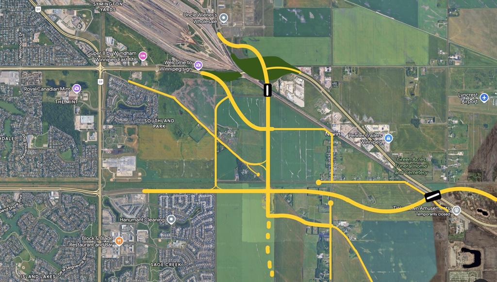
In the SouthEast Corner of Winnipeg, I feel like the road layout should be done similar to this. I remember looking at the plans for replacing the overpass for Fermor Ave with options to realign Fermor to bypass the Business Park, or just simply replace the overpass. I am for the idea of realigning the TCH to bypass the business park because it would connect to the future Abinoji Mikanah Expansion.

One flaw is that they've been planning to connect to expropriate through the Navin Acreage. I feel like it would be better for them to expand AM south of Navin Road to expropriate less properties. And another flaw is that if they bypass Fermor, there won't be very good access to Plessis Road/ Edward Schreyer Parkway.

These designs I decided to have Abinoji Mikanah connect seamlessly with Highway 1. The current Plessis Overpass would be knocked down and either have ESP go halfway between Plessis Road and Symington Road, or just a bit West of Symington Road. The segment of Fermor Ave between ESP and AM (North of the Tracks) would be downgraded to a Business Park arterial analagous to Scurfield Blvd.

As for the local roads, most of them would be severed except for wherever there are residential properties. Plessis between St Josephs Road to Abinoji would be closed, along with Navin between Plessis and West of Symington Road.

Overall, I think these designs would be more futureproof for future development. I always thought it would make sense if TCH 1 would connect with Abinoji Mikanah. And AM at ESP Intersection has more room for future Interchange flexibility. Above all, Abinoji Mikanah (TCH 1) East of ESP would be able to maintain its 100 km/h speed limit. Plus, this design would be great for drivers who are willing to go to the Airport as it connects directly to Route 90.

The flaw with this idea is that it would be harder for drivers who want to head to downtown. Going EB on AM, you'd go slightly North on ESP and turn left to go to Fermor Ave. OR maybe for simplicity, maybe AM between Perimeter and St Annes Road could carry the TCH 1 designation. St Annes Road would be marked as TCH 1 North of AM all the way to St Mary's.

There’s a pre existing turnoff on fermor that cuts through Dawson crossing and ties into Dawson just east of the Southland development. Dawson road will be widened quite a bit because the berms we built last fall were set back about 20 meters from the edge of the road.

Also if you look at Sage Creek there’s a future extension of Warde avenue that heads east across Dawson road into the field.

Edit - I have no idea how to upload photos or I’d draw it out. I also have a full set of plans for Dawson Crossing in pdf form.
Reply With Quote
     
     
  #8163  
Old Posted May 14, 2026, 8:37 PM
Mr Tall Forehead's Avatar
Mr Tall Forehead Mr Tall Forehead is offline
Registered User
 
Join Date: Jul 2024
Location: Winnipeg
Posts: 817
Reply With Quote
     
     
  #8164  
Old Posted May 15, 2026, 6:57 PM
Carboy15's Avatar
Carboy15 Carboy15 is offline
CanAutoroute1
 
Join Date: Oct 2022
Location: Centerville of Canada
Posts: 594
Quote:
Originally Posted by jim_bred View Post
There’s a pre existing turnoff on fermor that cuts through Dawson crossing and ties into Dawson just east of the Southland development. Dawson road will be widened quite a bit because the berms we built last fall were set back about 20 meters from the edge of the road.

Also if you look at Sage Creek there’s a future extension of Warde avenue that heads east across Dawson road into the field.

Edit - I have no idea how to upload photos or I’d draw it out. I also have a full set of plans for Dawson Crossing in pdf form.
Yeah, I see what Dawson Crossing is supposed to look like. But this is rather a rough sketch of how I feel like Abinoji Mikanah should tie in with the Perimeter. And Edward Schreyer Parkway would extend south to Abinoji a bit west of Symington.

It will probably be a while before anything gets built East of Plessis Road south of the tracks (it's RM of Springfield land currently, not city owned).
Reply With Quote
     
     
  #8165  
Old Posted May 21, 2026, 1:16 AM
Wpg_Guy's Avatar
Wpg_Guy Wpg_Guy is online now
Moderator
 
Join Date: Aug 2002
Location: Winnipeg, Manitoba
Posts: 7,449
Quote:
City seeking consultant to find St. Mary’s Road traffic solutions
Scott Billeck
Wednesday, May. 20, 2026


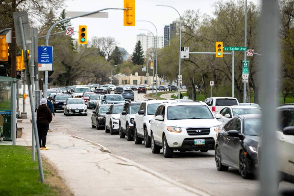
MIKAELA MACKENZIE / FREE PRESS

The four-lane section of St. Mary’s Road between Morier and Tache avenues creates a major bottleneck.


The City of Winnipeg is looking for ways to ease congestion and improve safety along one of the busiest routes into and out of downtown.

A newly issued request for proposals seeks a consultant to study a 1.5-kilometre stretch of St. Mary’s Road between Morierand Tache avenues, where more than 40,000 vehicles travel each day.

“It’s been a long path to get to here, so pleased we’ve arrived here and glad we’re at least starting in on this,” said St. Vital Coun. Brian Mayes, who has pushed for changes over the last 14 years, since being first elected in 2012. Discussions to look at possible changes to the stretch of road date back to 2005.

The city’s 2011 Transportation Master Plan had originally projected St. Mary’s Road would be widened between St. Anne’s Road and Tache Avenue by 2021, but St. Boniface Coun. Matt Allard opposes any widening efforts.

Allard, whose ward covers the majority of the 1.5-kilometre stretch, said Wednesday that he wants the RFP process to play out and see what the public service comes back with, reserving further comment until then.

According to the city, the four-lane section creates a major bottleneck because it narrows between wider six-lane portions of St. Mary’s to the north and south. The result is frequent congestion and “extreme” travel times, even during minor traffic disruptions.

The city wants the consultant to identify lower-cost improvements that could be made in the short- to medium-term without major reconstruction or widening of the roadway, which is mostly lined with residential homes and apartments along much of the stretch of road.

More significant upgrades — including road-widening and possible rapid transit and cycling infrastructure — are expected to be examined later as part of a broader future study of the St. Mary’s corridor.

The route has already been identified in the Winnipeg Transit Master Plan as part of a future rapid transit network, though it is not currently considered a top priority.

The city recently approved parking restriction changes along parts of St. Mary’s Road between Marion Street and Vivian Avenue, extending no-stopping rules during peak southbound rush-hour periods by a half-hour, from 3 p.m. to 6 p.m.

Mayes said he already has a few ideas that could help ease congestion along the corridor, including the possibility of reversible lanes that would add capacity in the direction of peak traffic flow.

Under that concept, a third northbound lane could open during the morning commute — possibly even one for transit — and switch to a third southbound lane during afternoon rush hour.

Mayes acknowledged the idea would be difficult to implement along the undivided stretch of St. Mary’s Road without widening the street, but said it may still be worth exploring if it means temporarily reducing traffic to a single lane in the opposite direction during peak periods.

He also suggested the city examine changes to the F7 transit route, which currently merges left as northbound traffic narrows from three lanes to two before turning right onto Carriere Avenue — a manoeuvre that frequently contributes to rush-hour backups.

“Could we extend that third lane as far north as Carriere?” Mayes said. “That would realign things a bit.”

The corridor has also been the site of several serious crashes in recent years.

In 2022, a 17-year-old passenger was killed and an 18-year-old driver injured after a vehicle slammed into a hydro pole near the bottleneck.

In October 2024, a vehicle travelling 213 km/h in a 60 km/h zone smashed into Midland Appliance World just north of Vivian Avenue.

Video footage showed the vehicle missing a curve before hitting a guardrail, hydro pole and the building, eventually coming to rest upside-down near Minute Muffler Auto Service Centre and a nearby bus stop. No one was injured.

At the time, Minute Muffler owner Max Traa said crashes are common along the northbound stretch of St. Mary’s near his shop, adding a stop sign at Morier Avenue had already been replaced multiple times following collisions since the 2024 crash.
Winnipeg Free Press
__________________
Winnipeg Act II - April 2024

Winnipeg Developments

In The Future Every Building Will Be World-Famous For Fifteen Minutes.
Reply With Quote
     
     
  #8166  
Old Posted May 21, 2026, 1:30 AM
Carboy15's Avatar
Carboy15 Carboy15 is offline
CanAutoroute1
 
Join Date: Oct 2022
Location: Centerville of Canada
Posts: 594
Great to hear they're making plans to improve the St Mary's Road stretch I mentioned lately. Long overdue, but it is indeed difficult because of the legacy infrastructure. But hopefully some progress can be made eventually.
Reply With Quote
     
     
  #8167  
Old Posted May 21, 2026, 2:42 AM
bomberjet bomberjet is offline
Registered User
 
Join Date: Nov 2012
Location: Winnipeg
Posts: 16,200
nevermind..
Reply With Quote
     
     
  #8168  
Old Posted May 28, 2026, 5:02 AM
Wpg_Guy's Avatar
Wpg_Guy Wpg_Guy is online now
Moderator
 
Join Date: Aug 2002
Location: Winnipeg, Manitoba
Posts: 7,449
__________________
Winnipeg Act II - April 2024

Winnipeg Developments

In The Future Every Building Will Be World-Famous For Fifteen Minutes.
Reply With Quote
     
     
  #8169  
Old Posted May 28, 2026, 9:54 PM
Wpg_Guy's Avatar
Wpg_Guy Wpg_Guy is online now
Moderator
 
Join Date: Aug 2002
Location: Winnipeg, Manitoba
Posts: 7,449
Quote:
Mayor launches defence, aerospace, aviation sector investment task force
By: Free Press staff
Posted: 2:41 PM CDT Thursday, May. 28, 2026

Mayor Scott Gillingham has created a task force to support his goal to expand Winnipeg’s “sky economy.”

Its members will determine infrastructure needs near Winnipeg Richardson International Airport over the next 10 to 25 years, aiming to boost the defence, aerospace and aviation sectors.

The Sky Economy Employment Zone Task Force will lay out needs related to the Royal Canadian Air Force, City of Winnipeg, Winnipeg Airports Authority, CentrePort Canada, the training sector and civilian partners.

The mayor said that information will help advocate for new investments.

“Winnipeg’s future economy is going to depend upon the growth of that area … (we need) the infrastructure in place to accommodate and enable that growth,” said Gillingham.

The task force will consist of Catherine Kloepfer, the city’s former chief financial officer, Matthew Dryburgh, the city’s acting deputy chief administrative officer, and Brian Kelcey, who works in the mayor’s office.

The task force is expected to report back to the mayor by July 15.
Free Press staff
__________________
Winnipeg Act II - April 2024

Winnipeg Developments

In The Future Every Building Will Be World-Famous For Fifteen Minutes.
Reply With Quote
     
     
  #8170  
Old Posted Jun 13, 2026, 12:56 AM
zalf zalf is offline
Registered User
 
Join Date: Jun 2020
Posts: 867
So what is the reserve depth of spare transformers for Hydro? If we get another storm like Tuesday's are we just hooped? I know the big ones are at substations are bespoke with long lead times, but are the small pole-top ones a commodity item?
Reply With Quote
     
     
  #8171  
Old Posted Jun 13, 2026, 2:19 AM
cllew cllew is offline
Registered User
 
Join Date: Feb 2012
Posts: 4,796
Quote:
Originally Posted by zalf View Post
So what is the reserve depth of spare transformers for Hydro? If we get another storm like Tuesday's are we just hooped? I know the big ones are at substations are bespoke with long lead times, but are the small pole-top ones a commodity item?
A Hydro system health report from 2012 says they replace about 2000 pole mounted transformers a year for various reasons, so they must have a substantial stock of new and rebuilt transformers at their Waverly distribution center for shipping to the hydro district yards.

I don't know how many the Canadian transformer manufacturing companies like Carte International on Logan would have in inventory for shipping out for emergencies
Reply With Quote
     
     
  #8172  
Old Posted Jun 16, 2026, 11:01 PM
OTA in Winnipeg OTA in Winnipeg is offline
Registered User
 
Join Date: Mar 2016
Location: Silver Heights
Posts: 1,798
Quote:
Originally Posted by bomberjet View Post
Nope. Not in the cities budget forecast. Which goes to 2031. It can always be added.
Not a rebuild but, I got home from work today and they've stripped the old asphalt away today. I expect new asphalt will be put down tomorrow. I am very thankful as this road (Fairlane) was really beating the shit out of our vehicles.
Reply With Quote
     
     
  #8173  
Old Posted Jun 17, 2026, 4:32 PM
bomberjet bomberjet is offline
Registered User
 
Join Date: Nov 2012
Location: Winnipeg
Posts: 16,200
Nice. The City crews will do work like that which is not listed in the budget forecast. It falls under some kind of maintenance budget. They do these mill and fills on bad streets that aren't in the budget.
Reply With Quote
     
     
  #8174  
Old Posted Jun 18, 2026, 3:12 AM
Wpgstvsouth94 Wpgstvsouth94 is offline
Registered User
 
Join Date: Aug 2020
Posts: 428
Quote:
Originally Posted by bomberjet View Post
Nice. The City crews will do work like that which is not listed in the budget forecast. It falls under some kind of maintenance budget. They do these mill and fills on bad streets that aren't in the budget.
They have been doing sections of Dakota. I don’t understand why they’re leaving the intersections in absolute despair. They are part of the problem on the road. the ride quality on northbound Dakota from nova Vista to Meadowwood is absolutely awful. It’s like sharp heaves in the road because they’re not fixing the concrete surface below, so it kinda has its negative effects.
Reply With Quote
     
     
  #8175  
Old Posted Jun 18, 2026, 4:58 AM
The Jabroni's Avatar
The Jabroni The Jabroni is offline
Go kicky fast, okay!
 
Join Date: Nov 2003
Location: Winnipeg, Donut Dominion
Posts: 3,355
I'm still not over how they completely did a full concrete pavement rebuild on eastbound Inkster for most of the stretch between Airlies and Main in 2024, and then the following year, did the westbound stretch in asphalt instead continuing the full rebuild.

Smooth, albeit still a bit abrasive concrete eastbound Inkster, while smooth yet ondulating bumps on westbound Inkster paved in asphalt.
__________________
Back then, I used to be indecisive.

Now, I'm not so sure.
Reply With Quote
     
     
  #8176  
Old Posted Jun 18, 2026, 12:58 PM
bomberjet bomberjet is offline
Registered User
 
Join Date: Nov 2012
Location: Winnipeg
Posts: 16,200
I wonder if it has to do with the original year of construction and condition of the pavement. There's definitely the train of thought that road surface does not need to be consistent. Even on the same direction of travel. Ie: concrete, to old concrete, to overlaid concrete, to just asphalt. I'm thinking of Grassie which is a mish mash of road surfaces based on whatever suits the current situation.
Reply With Quote
     
     
  #8177  
Old Posted Jun 18, 2026, 2:10 PM
CoryB CoryB is offline
Registered User
 
Join Date: Mar 2012
Posts: 6,171
Quote:
Originally Posted by The Jabroni View Post
I'm still not over how they completely did a full concrete pavement rebuild on eastbound Inkster for most of the stretch between Airlies and Main in 2024, and then the following year, did the westbound stretch in asphalt instead continuing the full rebuild.
There wasn't a lot of choice on the east bound Inkster side as the road needed to be fully removed for a water/sewer replacement. Obviously not needed on the west bound side.
Reply With Quote
     
     
  #8178  
Old Posted Jun 18, 2026, 8:05 PM
Wpgstvsouth94 Wpgstvsouth94 is offline
Registered User
 
Join Date: Aug 2020
Posts: 428
Quote:
Originally Posted by The Jabroni View Post
I'm still not over how they completely did a full concrete pavement rebuild on eastbound Inkster for most of the stretch between Airlies and Main in 2024, and then the following year, did the westbound stretch in asphalt instead continuing the full rebuild.

Smooth, albeit still a bit abrasive concrete eastbound Inkster, while smooth yet ondulating bumps on westbound Inkster paved in asphalt.
I know it’s insane.

Dakota isn’t just minor uneven sections. It’s the whole stretch is just awful.

Has there been any word on the intersections along Bishop this summer River Road and the westbound lanes from Saint Anne’s Road to Dakota?
Reply With Quote
     
     
  #8179  
Old Posted Jun 19, 2026, 2:48 PM
bomberjet bomberjet is offline
Registered User
 
Join Date: Nov 2012
Location: Winnipeg
Posts: 16,200
You guys should come see Munroe Ave from Gateway to Grey. They filled the potholes once again. It's dystopian. I hope they do a mill and fill like they did on Munroe a block over from Grey to London.
Reply With Quote
     
     
  #8180  
Old Posted Jun 19, 2026, 5:08 PM
neutroniks neutroniks is offline
Registered User
 
Join Date: Nov 2022
Posts: 960
Quote:
Originally Posted by The Jabroni View Post
I'm still not over how they completely did a full concrete pavement rebuild on eastbound Inkster for most of the stretch between Airlies and Main in 2024, and then the following year, did the westbound stretch in asphalt instead continuing the full rebuild.

Smooth, albeit still a bit abrasive concrete eastbound Inkster, while smooth yet ondulating bumps on westbound Inkster paved in asphalt.
It remind's me of when they re-did Erin St from Notre Dame all the way to Portage. They completely re-did the road. Dug out the ground and packed it heavy with stone and gravel, and I figured they were going to do full concrete like every other heavy truck route, and then to my surprise they actually did asphalt for the entire run. I don't know much about roads, but I would assume concrete would handle heavy trucks better than concrete. No?
Reply With Quote
     
     
This discussion thread continues

Use the page links to the lower-right to go to the next page for additional posts
 
 
Reply

Go Back   SkyscraperPage Forum > Regional Sections > Canada > Manitoba & Saskatchewan
Forum Jump


Forum Jump


All times are GMT. The time now is 10:10 AM.

     
SkyscraperPage.com - Privacy Statement - Top

Powered by vBulletin® Version 3.8.7
Copyright ©2000 - 2026, vBulletin Solutions, Inc.