I walked around the area of Moodie Station and the Corkstown Yard LMSF, on Saturday, July 3, 2026. I was hoping to make some sense of the flooding that occurred there two days earlier, on July 1. Here is what I have come up with:
I walked the area to observe any damage, but also to look for signs of where water had flowed. The damage was significant in only a few areas. For example, I saw two areas where the old freight line had been washed out. The worst was just north of Corkstown Road. This was due to water flowing downhill, along the north edge of Corkstown Road, across the tracks and into the field at Wesley Clover Equestrian Park. This water did not cross to the south side of Corkstown Road, thus did not have any effect on the LRT infrastructure.
A second, slightly smaller, wash-out occurred on that same freight line, south of the 417, where it crosses the western branch of Stillwater Creek. That water then flowed eastbound along the south side of the 417 to join the central branch of Stillwater Creek, about half way to Moodie Drive. Water from those two branches merged and did one of two things; it either flowed northbound through the culvert to the north side of the 417 (where the Corkstown Yard LMSF is located); or it continued flowing overland to flood the farm field and the 417 On and Off ramps in the south-west quadrant of the 417 - Moodie Drive interchange.
Image of the flooded interchange ramps:
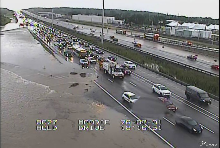
This flooding does not appear to have caused any serious damage to the roadways. Although there was some edge wash-out along the north edge of the eastbound lanes, in the median, just west of the Moodie overpass.
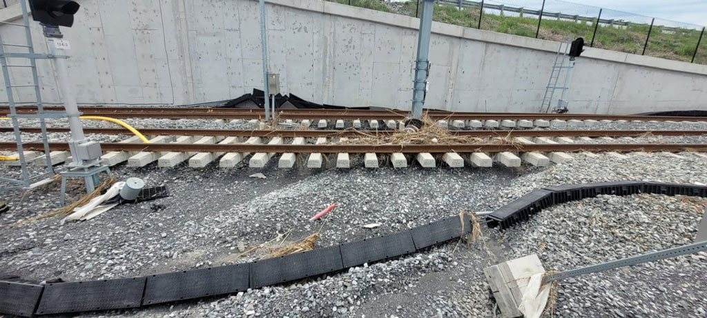
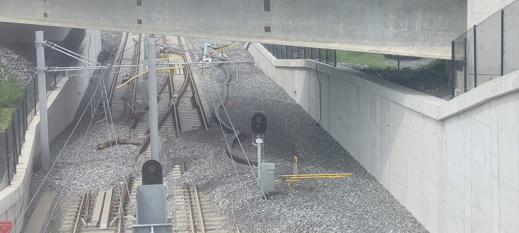
Water damage was more evident north of the 417, in the area of the rail connection between the Moodie LRT Station and the Corkstown Yard facilities. That section of track has a downward grade to the east, causing water to flow quite fast. This fast-moving water washed-out the ballast from under the tracks, and deposited it on the track switches, where the water slowed as it passed the low point.
Images of the scoured ballast:
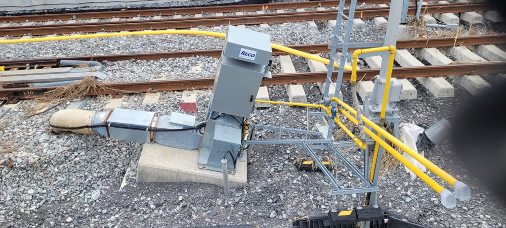
And it was a good thing that there was a flexible connector in the gas line to the switch heater. The base of it was under-cut and the heater shifted.
I think that there were a number of factors that led to the damage. First, and foremost, is the huge quantity of rain that fell in a relatively short period of time. But a greater rate of rainfall occurred on September 9, 2004. Obviously, there was flooding then, also. Luckily, there was no Corkstown Yard LMSF at that time, thus no LRT tracks to damage.
But let’s look at what has changed in this area. Here is what that area would have looked like during that previous exceptional storm:
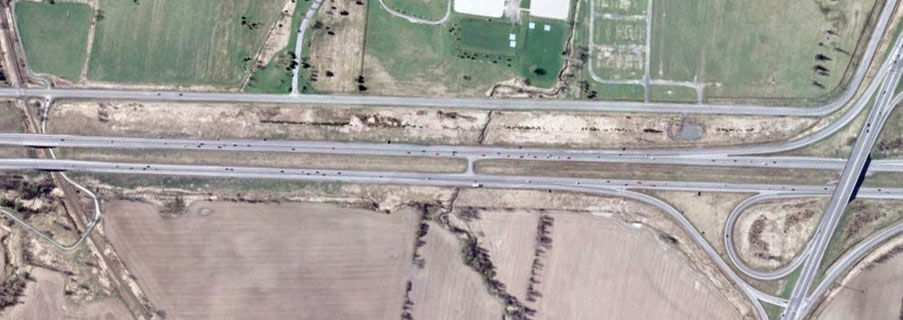
The 417 is three-lanes per direction (2 for general traffic, and 1 for buses-only), and has a wide median to collect stormwater. On the north side, there is a wide grass area between the 417 and Corkstown Road, that can catch and store any stormwater runoff. Thus, it mostly doesn’t matter if there is runoff from the 417.
But take a closer look at the eastern end of the image, just north of the On ramp from Moodie-SB to 417-WB:
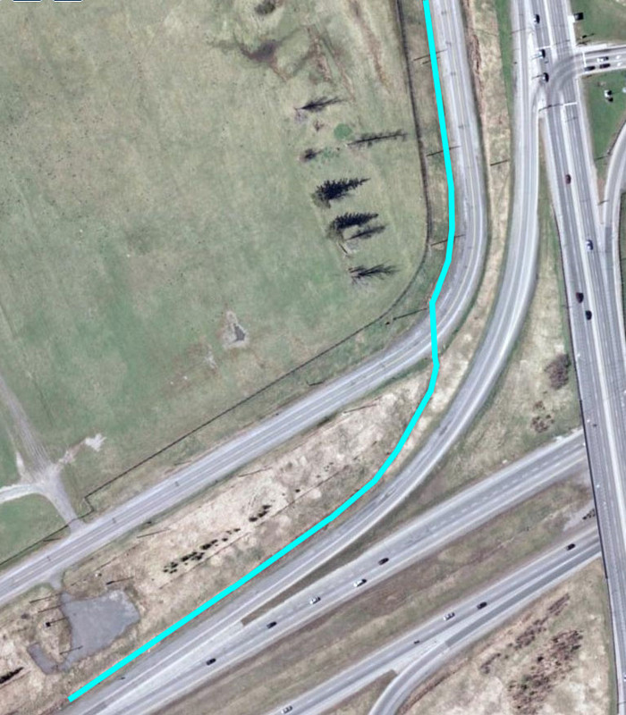
There was a ditch and culvert under Corkstown Road so that stormwater from that area could flow north to join Stillwater Creek. (I have highlighted it in light blue.) My thinking is that, if they went to the trouble of adding a ditch and culvert, it was because they found it necessary.
That ditch, along the On ramp, is no longer there. The culvert under Corkstown Road has been repurposed to only handle stormwater flowing from the midpoint of that On ramp – not its entire length.
Also, since that large storm in 2004, the 417 has had extra lanes added, and the stormwater storage area of the median has all but disappeared – meaning a lot more water will flow from the 417. That widening might not have mattered much, while there was still a wide stormwater buffer space on each side – but then came the Corkstown Yard LMSF.
So, as best I can figure, the stormwater flow went something like this.
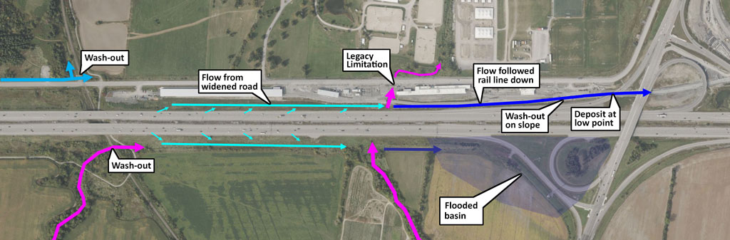
The legacy culvert, which carries the central branch of Stillwater Creek under Corkstown Road, looks to be the original one from when Corkstown Road was built. I expect that it is under-sized when it comes to the heavier rains that we now seem to have. It may have been adequate while there was limited additional stormwater flowing from the 417, but now it needs to allow the flow of the creek AND the 417 water. There was evidence that the stormwater overwhelmed that culvert. Increasing the size of the culvert may not be possible, since it would dump more water onto another owner’s property.
An alternative is to restrict the amount of stormwater flowing in that branch of Stillwater Creek as it passes under the 417, creating more flooding in the field to the south. This would likely require the 417-EB to Moodie-SB ramp to be elevated to form a dike – which might be a good idea anyway, based on the recent road flooding.
Although nothing can be 100% sure to prevent flooding/damage from a future bigger storm, I would suggest that they try to recreate the ditch along that Moodie-SB to 417-WB ON ramp. Have it flow in both directions, toward a center culvert (installed under the tracks, just west of the down-slope) that takes the water out to a ditch along the south edge of Corkstown Road. That ditch would then be reconnected, through the culvert to the original north-running ditch.





 Prev
Prev





 Linear Mode
