HomeDiagramsDatabaseMapsForum About
     

Go Back   SkyscraperPage Forum > Regional Sections > Canada > Ontario > Ottawa-Gatineau > Transportation


Reply

 
Thread Tools Display Modes
     
     
  #3201  
Old Posted Apr 30, 2025, 1:07 PM
rocketphish's Avatar
rocketphish rocketphish is online now
Planet Ottawa and beyond
 
Join Date: Feb 2009
Location: Greater Ottawa
Posts: 14,683
Auditor general clears up 'confusion' over Ottawa red-light camera revenue
New red-light cameras installed after 2020 generated $10.7 million that could have been transferred to the city’s road safety reserve fund, according to a report from Nathalie Gougeon.

By Aedan Helmer, Ottawa Citizen
Published Apr 30, 2025 | Last updated 4 hours ago


https://ottawacitizen.com/news/auditor-general-confusion-ottawa-red-light-camera-revenue
Reply With Quote
     
     
  #3202  
Old Posted May 7, 2025, 12:15 AM
rocketphish's Avatar
rocketphish rocketphish is online now
Planet Ottawa and beyond
 
Join Date: Feb 2009
Location: Greater Ottawa
Posts: 14,683
Was red light camera revenue really just a cash grab?
The muddled way in which this policy has been implemented would make some think so. Ottawa needs a more transparent process to get the money into road safety programs.

By Randall Denley, Ottawa Citizen
Published May 06, 2025


Ottawa city councillors have been working awfully hard to convince the public that the city’s red light camera program is not a cash cow, despite an auditor general’s report suggesting that it is. If anything, the situation is worse than the AG indicated.

Here’s what you need to know.

In 2019, city council approved a motion saying “all revenue from automated enforcement” — including automated speed enforcement and red light cameras installed since 2020 — should be allocated to the city’s road safety program.

The meaning of “all” would seem clear, but when it comes to red light cameras, city staff interpreted “all” to mean “none.” In the four years from 2021 to 2024, the city pulled in $41,309,146 in gross revenue from its red light cameras. Virtually all of it went either to the city’s general operating budget or the Ottawa police budget, Auditor General Nathalie Gougeon’s report said.

Had staff followed council’s orders, some $10.7 million in revenue from new red light cameras would have been transferred to the road safety program, the AG found.

At last week’s audit committee meeting, city financial staff attempted to counter that analysis by pointing out that “all revenue” really meant all net revenue, the money left over after the city’s costs. Sadly, the program was not meeting its targets so there was no such revenue.

City staff would have councillors and the public believe it was abundantly clear back in 2019 that the city’s costs would be deducted from the red light revenue. The report in 2019 had a line saying there would be no cost to the existing budget.

Even if one were to accept that implication, city staff’s next step was dubious, at best.

City staff rather generously assumed that annual revenue for the red light cameras would be $11.75 million, even though in 2020 it had been just $6.7 million. The road safety contribution would only kick in once the city revenue, minus the police share, exceeded $11.75 million. It hasn’t happened yet, despite increasing the number of cameras from 57 to 77.

The AG’s report doesn’t say how much revenue was actually left over after the city’s real costs, but it’s a rather large number. In response to a media inquiry, city financial staff say net revenue from red light cameras from 2021 to 2024 inclusive was $30.3 million. That’s definitely in the cash cow zone. Surely some of it could have been spent on road safety.

Meanwhile, the city’s much larger speed enforcement camera program is more transparent. Over four years, it has taken in $57.8 million, covered its expenses and paid $28.3 million into a road safety reserve. (If one wants to be generous, it could be said that all the speed camera money is for road safety, since operating the program is intended to reduce speeding.)

However, Gougeon’s report on red light cameras caused significant public reaction and red faces among councillors who like to point to the road safety program as a big benefit created by the red light cameras.

Gougeon’s report said the failure to put the funds in the reserve “means that these funds will not be used exclusively for road safety initiatives. This can impact the level of public trust in the program.”

And so it should. Some councillors were clearly surprised to discover that red light camera money didn’t go to road safety. Others seemed to know all about it.

To be fair, people should have expected that the city would recoup the costs of the program. Despite the wording of the 2019 motion, it’s unlikely that the intent was to drill a hole in the city budget.

The problem is that staff created a self-serving formula that subverts council’s own 2019 motion, leaving the red light program contributing no money for road safety. Most councillors appear quite content with that. Nothing to see here, folks. Drive on.

The AG has recommended that the city revisit the way it allocates red light camera money. Splendid idea. A staff report is expected late this year. This time, let’s try an honest approach.

Randall Denley is an Ottawa journalist and author. Contact him at [email protected]

https://ottawacitizen.com/opinion/red-light-camera-cash-grab

Reply With Quote
     
     
  #3203  
Old Posted May 16, 2025, 12:25 PM
Horus's Avatar
Horus Horus is offline
I ask because I Gatineau
 
Join Date: Jul 2013
Location: Aylmer (by way of GTA)
Posts: 1,214
The only surprising thing about this is that there were 'only' 5 of the top 10 worst Quebec roads to be found in Gatineau/Chelsea. I can think of at least 3 more in Hull/Aylmer alone that aren't listed.


Quote:
4 Gatineau, Que. streets among the worst roads in Quebec, poll finds

By Josh Pringle
Published: May 15, 2025 at 12:36PM EDT


Five of the top 10 worst roads in Quebec are located in Gatineau and the Outaouais.

CAA-Quebec released its 2025 list of the worst roads in the province, voted on by Quebecers.

The worst road in Quebec was Contour-du-Lac-à-Beauce Road in La Tuque – Mauricie.

The second worst road in Quebec, according to the vote, was Chemin Klock in Gatineau. Third was Chemin Notch in Chelsea and fourth was Chemin Cook in Gatineau. Fifth on the list of the 10 worst roads in Quebec was Chemin Pink in Gatineau, while Rue des Laurentides in Gatineau was 9th on the list.

The CAA has been conducting the worst roads campaign in Quebec for 10 years. Residents are invited to let the CAA know which roads are in the worst condition, whether due to neglected maintenance and markings or “even shoddy sidewalks.”

“CAA-Quebec will then produce its now-famous ranking of the Worst Roads and pursue its objective of raising awareness of road infrastructure maintenance among cities and the Ministère des Transports et de la Mobilité durable,” the CAA said.
https://www.ctvnews.ca/ottawa/article/4-...ng-the-worst-roads-in-quebec-poll-finds/
Reply With Quote
     
     
  #3204  
Old Posted May 22, 2025, 8:54 PM
rocketphish's Avatar
rocketphish rocketphish is online now
Planet Ottawa and beyond
 
Join Date: Feb 2009
Location: Greater Ottawa
Posts: 14,683
What it will take to fix Ottawa’s ‘stroad’ problem
Streets were designed for slower speeds. Roads were designed to move vehicles as quickly as possible. A stroad attempts to do both.

By Sadeen Mohsen, Ottawa Citizen
Published May 22, 2025 | Last updated 2 hours ago


<snip>

A ‘stroad?’ What’s a stroad?

The issue that connects Beechwood Avenue, Innes Road and Industrial Avenue is that their road structures are considered “stroads.”

“Stroad” is a portmanteau of “street” and “road,” coined by Charles Marohn in 2011 to describe certain urban thoroughfares that combine elements of two types of roadway.

Streets were designed so that slower speeds would be required to be safe around businesses, neighbourhoods and high-pedestrian traffic. Roads were designed to move vehicles as quickly as possible through traffic and support high-speed environments. A stroad attempts to do both at the same time.

<lots more>

https://ottawacitizen.com/news/ottawas-stroad-problem
Reply With Quote
     
     
  #3205  
Old Posted May 31, 2025, 2:57 AM
rocketphish's Avatar
rocketphish rocketphish is online now
Planet Ottawa and beyond
 
Join Date: Feb 2009
Location: Greater Ottawa
Posts: 14,683
Thousands of ‘obstructed’ licence plates captured by Ottawa’s red light, photo radar cameras

By Josh Pringle, CTV News
Published: May 30, 2025 at 6:37AM EDT


Thousands of Ottawa motorists have escaped potential tickets for photo radar and red-light camera infractions due to hidden, damaged and missing licence plates, costing the City of Ottawa millions of dollars in lost fine revenue.

Tickets for red light and photo radar camera infractions are issued to the registered plate owner of the vehicle after an officer views the evidence.

Statistics provided to CTV News Ottawa show 15,480 vehicles with damaged, obstructed or missing licence plates were captured by Ottawa’s automated speed enforcement cameras in the first three months of this year.

A total of 71,238 speeders caught by the photo radar cameras in 2024 were rejected due to unreadable plates, while 52,851 vehicles captured by the cameras in 2023 had damaged, obstructed or missing plates.

“The total number of these instances represent a small number of cases overall,” Roger Chapman, Director of Bylaw and Regulatory Services, said in a statement to CTV News Ottawa.

“For example, the number of incidents captured by automated speed enforcement cameras involving vehicles with damaged or obstructed plates or missing plates represents about 13 per cent of the total incidents captured per year.”

A total of 1,502 vehicles caught running red lights by Ottawa’s red-light cameras between January and April had damaged, obstructed or missing licence plates. In 2023 and 2024, a total of 8,006 vehicles caught by Ottawa’s red-light cameras had obstructed licence plates.

“It is important to note that incidents captured by a camera are not automatically tickets,” Chapman said.

“The evidence must first be substantiated by an officer, following which a Notice of Offence is issued.”

A report for the finance and corporate services committee meeting on June 3 says there was a $1.5 million deficit in the Traffic Service department through the first three months of the year “primarily due” to lower-than anticipated revenues from photo radar cameras. Staff said inclement weather and changes in driver behaviour resulted in lower revenue from photo radar tickets, but covered or damaged licence plates resulted in potentially 15,480 speeding tickets not issued in the January to March period.

Under Section 13 of the Highway Traffic Act, drivers are required to ensure their licence plates are unobstructed, properly mounted, and clearly visible to officers and enforcement technology.

The fine for an obscured licence plate is $110.

The Ottawa Police Service said in February that it regularly conducts enforcement targeting improper or obstructed licence plates, but notes some drivers deliberately obscure or alter their plate to avoid photo radar or red-light cameras, “making enforcement more complex.”

In a report for the Ottawa Police Services Board meeting on Feb. 24, Chief Eric Stubbs said another challenge is resource allocation, noting officers must balance enforcement of plate visibility with other traffic enforcement priorities, like speeding and aggressive driving.

“While significant progress has been made, the high number of unreadable plates remains a concern, particularly in relation to the effectiveness of ASE cameras and broader road safety objectives,” Stubbs said in the report for the February board meeting.

“OPS will continue to support the City of Ottawa’s initiatives by enforcing license plate regulations and exploring opportunities for enhanced collaboration in addressing this issue.”

https://www.ctvnews.ca/ottawa/article/th...y-ottawas-red-light-photo-radar-cameras/
Reply With Quote
     
     
  #3206  
Old Posted May 31, 2025, 2:58 AM
rocketphish's Avatar
rocketphish rocketphish is online now
Planet Ottawa and beyond
 
Join Date: Feb 2009
Location: Greater Ottawa
Posts: 14,683
Section of Queen Elizabeth Driveway to close to vehicles this summer for construction

By Josh Pringle, CTV News
Updated: May 30, 2025 at 7:18PM EDT | Published: May 30, 2025 at 8:46AM EDT


A section of Queen Elizabeth Driveway will be closed this summer for rehabilitation work on the 113-year-old Patterson Creek Bridge, forcing the Ottawa Redblacks to cancel shuttle bus service from City Hall to TD Place.

The National Capital Commission says a “short portion” of the road along the Rideau Canal will be closed, but dates have yet to be finalized.

“The NCC informed OSEG several weeks ago of the upcoming rehabilitation project on the 113-year-old Patterson Creek Bridge and its impact, to give them sufficient time to make alternate arrangements using nearby municipal roadways,” the NCC said in a statement to CTV News Ottawa.

“This important rehabilitation work will involve repairing the concrete and railings and widening the multi-use pathway to enhance accessibility for all users. The bridge reconstruction will require a closure on a short portion of QED to be closed to vehicular traffic. Timelines are still being finalized, and we will share more detailed information, including specific dates and traffic management plans, as soon as they are confirmed.”

According to the federal government, the repairs to the Patterson Creek Bridge include various types of concrete repairs on soffit and abutments, the installation of a concrete distribution slab to support widening the bridge, waterproofing and asphalt work, improving surface drainage, and the enhancement and widening of the multi-use pathway and sidewalk.

The City of Ottawa told CTV News Ottawa Friday afternoon a section of Queen Elizabeth Driveway is expected to be closed from mid-spring to mid-fall, and the city is coordinating with the NCC to finalize any required detours.

Redblacks fans are being warned there will be no shuttle bus from Ottawa City Hall to TD Place this season due to anticipated closures on part of Queen Elizabeth Driveway.

In a note to fans, the Redblacks say there will be no more “Park and Shuttle” service from Ottawa City Hall to TD Place on game days. Fans have been able to park at City Hall and then use a shuttle bus to get to games at TD Place.

“The City Hall Park & Shuttle service will no longer be available for Redblacks gamedays due to anticipated Queen Elizabeth Driveway closures,” the Redblacks said.

Fans can park for free at Canada Post or park at Carleton University lots (P5, P7, P18) for $6 and there will be a shuttle bus to games.

Your game day Redblacks ticket includes a free ride on OC Transpo starting three hours before and 90 minutes after the game.

The City of Ottawa says it worked with the Ottawa Sports and Entertainment Group (OSEG) on alternate options for fan parking.

“We assisted Lansdowne Park/OSEG in changing shuttle routes and proposing different possible offsite lot pick up locations,” Heidi Cousineau, manager of Traffic, Safety and Mobility with Ottawa’s Public Works department, told CTV News Ottawa.

“The end decision lied with OSEG in determining how best to redivert those who used to park at City Hall. As such they have put forth three off-site locations: St-Laurent, Carleton and Canada Post.”

https://www.ctvnews.ca/ottawa/article/no...ttawa-city-hall-to-td-place-this-season/
Reply With Quote
     
     
  #3207  
Old Posted Jun 11, 2025, 12:06 AM
rocketphish's Avatar
rocketphish rocketphish is online now
Planet Ottawa and beyond
 
Join Date: Feb 2009
Location: Greater Ottawa
Posts: 14,683
This vehicle will help the City of Ottawa better manage traffic

By William Eltherington, CTV News
Published: June 10, 2025 at 3:34PM EDT


Residents might notice a City of Ottawa vehicle with a mounted camera driving around this summer.

The city’s mobile mapping unit will be going around Ottawa to capture imagery and data to plan and improve traffic infrastructure.

The SUV, mounted with precision 360-degree cameras and LiDAR sensors, will help city staff plan and create a digital inventory of traffic assets as part of the Mobile Mapping of Traffic Infrastructure Project.

“The collected data is then processed and analyzed to create a comprehensive inventory of assets such as traffic lights, signage, paint lines and other traffic-related infrastructure,” the city says on its website.

“This initiative leverages new technologies to improve data accuracy, reduce repeat site visits by City staff and lower operational costs in managing the City’s traffic assets. It aims to enhance the quality of traffic infrastructure by improving the quality and timeliness of information used for planning upgrades and repairs.”

The mobile mapping unit will be gathering its data throughout the city until August.

Personal information, including images of identifiable individuals and licence plates, will not be held.

The city has used similar technology to create a 3D interactive map that visualizes potential future development as part of the New Zoning Bylaw.

https://www.ctvnews.ca/ottawa/article/th...he-city-of-ottawa-better-manage-traffic/
Reply With Quote
     
     
  #3208  
Old Posted Jun 18, 2025, 2:54 AM
rocketphish's Avatar
rocketphish rocketphish is online now
Planet Ottawa and beyond
 
Join Date: Feb 2009
Location: Greater Ottawa
Posts: 14,683
It took a member of the community to see this and raise the issue? Really? No construction worker stopped and said to themselves: "Gee, this might not be right, I should report this so it can be relocated".

Quote:
Hydrant is an obstacle on Ottawa sidewalk

By Josh Pringle, CTV News
Updated: June 17, 2025 at 4:51PM EDT | Published: June 17, 2025 at 10:55AM EDT


Pedestrians will have to navigate around a large yellow obstacle while walking near the new Ottawa Hospital Civic Campus.

A fire hydrant is in the middle of the newly constructed sidewalk at the intersection of Carling Avenue and Champagne Avenue.

Shaun Hopkins emailed photos of the hydrant in the middle of the sidewalk to CTV News Ottawa on Monday, asking, “How does this make sense?”

In a statement to CTV News Ottawa Tuesday afternoon, the city said it is assessing the current location of the hydrant.

“The City of Ottawa prioritizes accessibility and values the community’s attention to this matter,” Court Curry, manager of Right of Way, Heritage and Urban Design, said in an email.

“We are aware of the fire hydrant placement at the intersection of Carling Avenue and Champagne Avenue and are currently assessing its location in relation to the new sidewalk, underground infrastructure, and overall design considerations.”

Public Works and Infrastructure Committee chair Coun. Tim Tierney says this will be fixed.

“I’ve spoken with the general manager, this will be rectified,” he said. “This is not how we do business in the city, we want to ensure accessible sidewalks for everybody. Regardless of who made the error, it has to be corrected and will be corrected.”

With files from CTV News Ottawa’s Tyler Fleming

https://www.ctvnews.ca/ottawa/article/hydrant-is-an-obstacle-on-ottawa-sidewalk/
Reply With Quote
     
     
  #3209  
Old Posted Jun 18, 2025, 1:24 PM
Richard Eade Richard Eade is offline
Registered User
 
Join Date: Mar 2008
Location: Nepean
Posts: 2,673
This is certainly not a unique instance of a hydrant being left in place while the surface is reconfigured. What I have been told is that moving wires is pretty easy, but moving underground water and sewer infrastructure is at a whole other level (literally and figuratively). Most budgets for a wider sidewalk don’t include the added expense of moving hydrants – that simply reduces the amount of money left for sidewalks (i.e., results in much less sidewalk being poured).

In the case shown above, the hydrant is not an impediment – not any more than the pedestals are. There is a good 3’-4’ path around it. Wheelchairs, scooters, and snow plows can easily maneuver past that hydrant.
Reply With Quote
     
     
  #3210  
Old Posted Jun 18, 2025, 4:45 PM
Richard Eade Richard Eade is offline
Registered User
 
Join Date: Mar 2008
Location: Nepean
Posts: 2,673
The CAA funded a study of near-misses at intersections. Merivale and Meadowlands was included (on the suggestion of City staff).

https://www.caa.ca/app/uploads/2025/06/FINAL-REPORT_CAA-Intersection-Safety-Study_English.pdf

CORRECTION: The media tells me that the intersection was Merivale and Viewmount.

Something not listed in the study was whether the pedestrians and cyclists were following the proper rules when the near-misses occurred.

Last edited by Richard Eade; Jun 18, 2025 at 5:06 PM.
Reply With Quote
     
     
  #3211  
Old Posted Jun 18, 2025, 4:59 PM
zzptichka zzptichka is online now
Registered User
 
Join Date: Dec 2015
Location: Outaouias
Posts: 2,398
So what happend there? There was seemingly more space between the road the the hydrant before. Did they increase the turn radius?

__________________
My aerial Ottawa photos on Flickr 📷
Reply With Quote
     
     
  #3212  
Old Posted Jun 18, 2025, 5:55 PM
Richard Eade Richard Eade is offline
Registered User
 
Join Date: Mar 2008
Location: Nepean
Posts: 2,673
The distance from the catch basin on Carling and the hydrant appears to be about the same, but the distance from the manhole towards Champagne appears larger – as if Champagne were narrowed. (Based on the number of lines atop the manhole, I doubt that it was moved.) Narrowing Champagne would seem odd, though, since the other side of Carling will be the extension of Champagne, which will be the main public entrance to the hospital campus.

According to the bus-lane plans, Champagne is still to have three lanes at the intersection (R-turn, L-turn, & NB).

According to notices from the City, the work is to facilitate the O-Train Trillium Line (west-side) Pathway work. Recall that there is supposed to be a pathway along the west side of the Trillium Line, from the Young St. E to Carling. (In fact, I believe that the MTO left space for that pathway to continue north, under the 417.) However, I feel that a reconstruction of the Carling – Champagne intersection would be too far west for that.

I guess, the short answer is that I don’t know the answer.
Reply With Quote
     
     
  #3213  
Old Posted Jun 18, 2025, 6:05 PM
J.OT13's Avatar
J.OT13 J.OT13 is offline
Moderator
 
Join Date: Mar 2012
Location: Ottawa
Posts: 29,131
Reply With Quote
     
     
  #3214  
Old Posted Jun 18, 2025, 7:11 PM
urbanforest urbanforest is offline
Registered User
 
Join Date: Mar 2023
Posts: 339
Quote:
Originally Posted by zzptichka View Post
So what happend there? There was seemingly more space between the road the the hydrant before. Did they increase the turn radius?

It looks to me like they rightly widened the sidewalk.
Reply With Quote
     
     
  #3215  
Old Posted Jun 19, 2025, 3:50 PM
OTownandDown OTownandDown is offline
Registered User
 
Join Date: Jul 2018
Posts: 1,636
Lol, clearly none of y'all have tried to walk down Bank Street heading north of Lansdowne, god forbid on a busy event day.

Pffft, one single hydrant. Bank Street in the Glebe says "hold my beer"

https://maps.app.goo.gl/cKDWxrE9Gw5LpqXJ6

Quote:
Originally Posted by rocketphish View Post
It took a member of the community to see this and raise the issue? Really? No construction worker stopped and said to themselves: "Gee, this might not be right, I should report this so it can be relocated".
Reply With Quote
     
     
  #3216  
Old Posted Jul 10, 2025, 3:55 PM
Spoonsy's Avatar
Spoonsy Spoonsy is offline
You call that a knife?
 
Join Date: Jul 2016
Location: Centretown West
Posts: 328
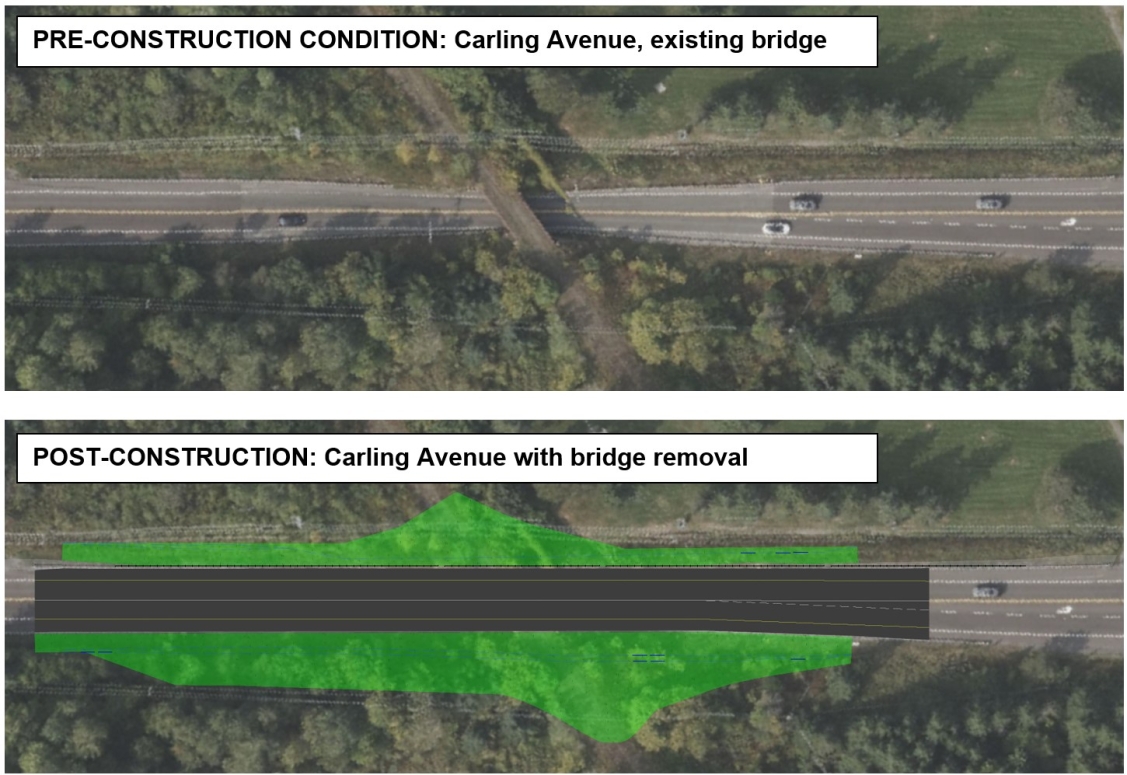
I don't think I saw this mentioned on this forum, sorry if this is repeat news - old CN rail bridge over Carling by the Shirley's Bay Campus is being removed


press release: https://www.ottawa.ca/en/city-hall/city-...-rail-bridge-over-carling-avenue-removed

Quote:
Traffic impacts expected as former CN Rail bridge over Carling Avenue is removed

Carling Avenue will be closed between Moodie Drive and Herzberg Road from Friday, July 18 to Sunday, July 27 for the former CN Rail bridge removal to make room for a safer, wider Carling Avenue.

The former CN Rail bridge crosses over Carling Avenue approximately 0.4 kilometres east of Burke Road and is no longer in use. Before construction began, Carling Avenue narrowed to pass under the rail overpass with no road shoulders, leaving a reduced and substandard space for motorists and cyclists to pass through.

To improve safety for all road users, the bridge and abutments will be removed, and the road will be reconstructed to provide continuous paved shoulders through the project limits.

Construction is scheduled to be completed by late August and there are expected traffic impacts until then:

Closure of Carling Avenue between Moodie Drive and Herzberg Road between Friday, July 18 and Sunday, July 27
A detour will be in place directing traffic to Moodie Drive, Robertson Road, Eagleson Road and Herzberg Road
A separate cycling detour will be signed for cyclists to use the Watts Creek Pathway
Access to all private driveways and entrances to businesses will be maintained during construction
Detour signage will be in place, please plan ahead.
project site: https://ottawa.ca/en/city-hall/public-en...ion-611f2e15-3503-46df-9208-0bebdff35640

Reply With Quote
     
     
  #3217  
Old Posted Jul 19, 2025, 4:54 AM
rocketphish's Avatar
rocketphish rocketphish is online now
Planet Ottawa and beyond
 
Join Date: Feb 2009
Location: Greater Ottawa
Posts: 14,683
Photo radar cameras will be installed in 24 locations across Ottawa by the end of 2025

By Josh Pringle, CTV News
Published: July 18, 2025 at 8:16AM EDT


An extra eye will be installed on 24 roads across Ottawa this fall to watch out for speeders as the City of Ottawa expands the automated speed enforcement camera program.

Signs have been installed to warn motorists that photo radar cameras will be activated within the next 90 days at 24 locations, including on Bank Street outside Lansdowne Park and in Dunrobin, Manotick and Richmond.

There are currently 60 photo radar cameras set up in community safety, school zones and “high speed” zones across the City of Ottawa.

The City of Ottawa plans to install 24 new photo radar cameras in 2025, but no cameras have been installed so far this year.

A City of Ottawa spokesperson told CTV News Ottawa that construction is expected to begin in early/mid August to install the 24 new automated speed enforcement cameras, “with the goal of having all cameras operational by late fall.”

Signs stating “Municipal Speed Camera Coming Soon” have been installed in the 24 locations to warn motorists that the photo radar camera will soon be operational. Under Ontario regulations, the “Municipal Speed Camera Coming Soon” sign must be installed at least 90 days before enforcement begins to provide adequate warning to motorists that a photo radar camera will be operational.

Statistics show 138,303 speeding tickets were issued through the automated speed enforcement camera program in the first five months of the year. The busiest photo radar is on King Edward Avenue, between Bolton Street and St. Patrick Street, with 15,766 tickets issued in the January to May period.

Here is the list of locations for the new automated speed enforcement cameras in 2025:
  • Abbott Street East between Iber Road and Robert Grant Avenue
  • Bank Street from Exhibition Way to Wilton Crescent
  • Bearbrook Road between the continuation of Bearbrook Road and Westpark Drive North
  • Carriere Street from Orleans Boulevard to Michaelsem Street
  • Conroy Road from Lorry Greenberg Drive to Hunt Club Road
  • Donald Street from Barnaby Private to Telford Avenue
  • Dunrobin Road from Porcupine Trail to Thomas A. Dolan Parkway (Village of Dunrobin)
  • Fisher Avenue between Trent Street and McCooey Lane
  • Fisher Avenue between Meadowlands Drive and Urbisci Private
  • Klondike Road between Sandhill Road and Marconi Avenue
  • Lanark Avenue from Beechgrove Avenue to Briarway Private
  • Longfields Drive from Mountshannon Drive to Silver Sage Avenue
  • Manotick Main Street from Bankfield Road to Highcroft Drive (Village of Manotick)
  • McArthur Avenue from Irwin Miller Street to Brant Street
  • Meadowlands Drive East between Chesterton Drive and Tiverton Drive
  • Old Richmond Road from Sanibel Private to Seyton Drive
  • Osgoode Main Street from Elizabeth Street to Vance Street
  • Perth Street between Cockburn Street and King Street North (Village of Richmond)
  • River Run Avenue between Dovetail Heights and Grand Canal Street
  • Rockdale Road between Horizon Drive and Buckland Road
  • St. Georges Street between Marconi Drive and Galloway Drive
  • Stonehaven Drive between Bridlewood Drive and Tamara Way
  • Valin Street from Winsome Terrace to Provence Avenue
  • Woodridge Crescent at Bayshore Drive near Bayshore Public School

https://www.ctvnews.ca/ottawa/article/ph...ations-across-ottawa-by-the-end-of-2025/
Reply With Quote
     
     
  #3218  
Old Posted Jul 19, 2025, 2:06 PM
lrt's friend lrt's friend is offline
Registered User
 
Join Date: Dec 2006
Posts: 12,811
After all the high administrative costs and maintenance costs, is the city making any money off this? With city so cash strapped, this better not be a money loser.

As we continue to build an auto focused city, increasing traffic is the number one risk to pedestrians and cyclists.
Reply With Quote
     
     
  #3219  
Old Posted Jul 19, 2025, 2:11 PM
ponyboycurtis's Avatar
ponyboycurtis ponyboycurtis is offline
Cigritbutt enthusiast
 
Join Date: Apr 2021
Location: Blahttawa
Posts: 1,685
Be advised I saw a trailered sign yesterday that said Hunt Club west of Bank st. will be getting resurfaced.. presumably just the stretch to Aviation parkway interchange.

Starts July 22 so you might want to avoid that spot like the plague if you can. I marked it on my calendar with a strike through for the week
__________________
I don't understand how communism works.
Reply With Quote
     
     
  #3220  
Old Posted Jul 23, 2025, 3:01 PM
rocketphish's Avatar
rocketphish rocketphish is online now
Planet Ottawa and beyond
 
Join Date: Feb 2009
Location: Greater Ottawa
Posts: 14,683
Time to say goodbye to this 100-year-old CN Rail bridge in Ottawa

CBC News
July 23, 2025


Video
Duration 3:37

It’s the end of an era for a century-old CN Rail bridge on Carling Avenue. CBC's Sannah Choi takes one final look at the infamous underpass.

https://www.cbc.ca/player/play/video/9.6841142
Reply With Quote
     
     
This discussion thread continues

Use the page links to the lower-right to go to the next page for additional posts
 
 
Reply

Go Back   SkyscraperPage Forum > Regional Sections > Canada > Ontario > Ottawa-Gatineau > Transportation
Forum Jump


Forum Jump


All times are GMT. The time now is 2:42 AM.


Powered by vBulletin® Version 3.8.7
Copyright ©2000 - 2026, vBulletin Solutions, Inc.