Quote:
Originally Posted by ThatDarnSacramentan

While there's precedent for large parking garages over a freeway like in Minneapolis at Target Center, I don't think the conditions present at our site would allow for that. Among other things, I-5 is higher than Moody in elevation, and it's also not a straight alignment but instead the whole spaghetti tangle between I-5, 405, the Marquam Bridge, and the Ross Island Bridge.
As I look at the site in Google Maps more, it wouldn't surprise me if there wouldn't be at least a handful of people parking up at OHSU and taking the aerial tram down, although if my memory's right, the tram doesn't run on Sundays.
Realistically, probably the best opportunity for a large parking garage would be replacing the OHSU lot directly across from Caruthers Park. Put 5 or 6 levels of parking there, some retail on the ground floor fronting the park, and people just walk a few blocks to the stadium. There would also be the added benefit of gaining access from Macadam, which might help smooth traffic in/out.
|
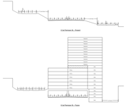
I was stuck at home with a cold this afternoon, so I sketched up a concept for a cap. It's feasible, and the economics are surprisingly good. The sketch is drawn looking north at Pennoyer St.
Key components:
- Moving the NB Macadam lanes up to Hood Ave makes for a continuous 4-lane arterial from S Macadam (at Bancroft) onto S Hood Ave onto S Kelly Ave. It allows for the removal of the Kelly Ave flyover and opens up a lot of land for development. Macadam at S Waterfront would be a woonerf.
- Caps could run from S Abernethy to the Tilikum Crossing, about 10 blocks. The cross-section is typical south of Gibbs. North of Gibbs things are bit wild right now. However, almost all of the ramps could be removed. They function poorly, and they could be replaced with intersections. Many of them are already planned for removal as part of the Ross Island bridgehead project. Furthermore, if it makes sense economically, the NB I-5 Marquam bridge approach ramp could be relocated to parallel the SB I-5 descending ramp. This would open up about 5 blocks for development (right next to the stadium), and would make I-405 NB exit a more standard right lane exit.
- Freeway caps are most affordable when they aren't used to support building columns. This means either using the caps for parks or designing the buildings to span over the caps, only bearing at the cap support points. The latter strategy works well for caps with spans in the 55 ft - 65 ft range. Elsewhere in the country caps have typically been built with 90' spans (Denver, Dallas, Pittsburgh, Phoenix, Rose Quarter (well, 81 ft))--generally impractical for buildings to span over, even with transfer girders. The spans shown here are 65 ft, and would allow for four lanes in both directions.
Economics:
- Assume caps cost $750/sf. Denver's recent project (with 90' spans, requiring 2x strong structural members as 65' spans) cost $720/sf.
- One block of 250' long x 130' wide cap costs $24.4 million.
- Land value of one block in the S Waterfront is ~$10 million/block (
https://www.portlandmaps.com/detail/property/3930-S-BOND-AVE/R712506_did/). A 200,000 sf property brings in $770,000/year in property taxes. Break-even on a single block would be ($24.4 - $10)/$0.77 = 19 years.
- Constructing the whole thing would cost ~$250 million, with with $100 million directly offset by the value of the land created. Value capture could be used to generate, say, $50 million from adjacent parcels (the market value of the parking lot at Lane St adjacent to the freeway is $6 million, half the value of the land two blocks east). That leaves $100 million, which could come as a grant, or could be a loan repaid with the first 13 years of building property tax revenue.
Back-of-the-envelope math, obviously. But I think it shows that caps here are technically and economically feasible.





 Prev
Prev




 Linear Mode
