HomeDiagramsDatabaseMapsForum About
     

Go Back   SkyscraperPage Forum > Regional Sections > Canada


Reply

 
Thread Tools Display Modes
     
     
  #1541  
Old Posted Mar 23, 2024, 1:45 PM
megadude megadude is offline
Registered User
 
Join Date: Sep 2017
Location: N. York/Bram/Mark/Sauga/Burl/Oak/DT
Posts: 3,681
Quote:
Originally Posted by ScreamingViking View Post
Brings to mind the "tri-state" and "tri-county" areas oft-mentioned in U.S. films and shows. Quad-muni is a step up, though perhaps less verbally appealing.

And I wonder if Samuel Ryckman was the same surveyor whose name was coined for 6 & 53 (now Upper James and Rymal) in south Hamilton.
There are houses on all four corners of this place. I wonder if the neighbours talk to each other about what their property tax rates are and what services they get. Milton and Halton Hills are in Halton Region. Erin and Guelph/Eramosa are Wellington County. For instance, does the Halton Region side get garbage pickup like residents in the populated cenrtres would, while the others on the Wellington side have to drive theirs to a dump or hire a private service because their municipalities are more rural in general?

When I hear tri state area, etc. it's funny to me because the states are so different from each other. It's even very noticeable for tri county. Some counties sell booze while others, like Sevier County, home of Jack Daniels, are completely dry. When I was in FLA, I wanted booze at like 8pm, but Coral Springs didn't allow sales at night or something so the gas station guy told me to drive a few minutes south into whatever town that was to get some. They are both in Broward County. So even town by town differs quite a bit. Just look at their police. There are 31 incorporated communties in Broward. Almost all of them, if not all, have their own police force with their cars driving around.

London might not be so obvious because it's all jammed together, but there are 32 boroughs that make up Greater London. There used to be 86. All with different characteristics in some respect. For instance, different styles of street signs and bike lanes being on one side of the road and then the other side when entering the next borough.
Reply With Quote
     
     
  #1542  
Old Posted Mar 25, 2024, 3:05 PM
jonny24 jonny24 is offline
Registered User
 
Join Date: Aug 2017
Location: Caledonia, often in Hamilton and Norfolk
Posts: 1,753
Quote:
Originally Posted by ScreamingViking View Post
Peter's Corners

I seem to recall some in the rural parts of Niagara and Haldimand and Norfolk. Can't think of their names offhand though.
Norfolk has two separate "Bill's Corners", but only one pops up on Google maps - both have Norfolk Country road signs marking them. "Bill's Corners" that appears on Maps is just west of Simcoe, while "Bills Corners" (no apostrophe) is northwest of Waterford.

Streetview of the roadsign marking it:

https://www.google.com/maps/@42.9633412,...Q5UgVRDLTBw!2e0!7i16384!8i8192?entry=ttu

Maps directions between the two:

https://www.google.com/maps/dir/Bill's+C...374733!2d42.813105!1m1!4e1!3e0?entry=ttu
Reply With Quote
     
     
  #1543  
Old Posted Mar 27, 2024, 2:18 PM
Taeolas Taeolas is offline
Registered User
 
Join Date: Oct 2009
Location: Fredericton
Posts: 5,102
Quote:
Originally Posted by MonctonRad View Post
Orwell Corner and Poole’s Corner PEI, and Sussex Corner NB (off the top of my head). I’m sure there are others.
It's not incorporated, but Richmond Corner is part of Woodstock New Brunswick, on the road to Houlton, Maine. It's basically where the Old Houlton Road meets the roads to Debec and Redbridge. Checking google I see McKenzie Corner and Brigg's Corner and Union Corner in the area too. Seems to be a whole lot of corners all around eastern New Brunswick now that I look at Google.
Reply With Quote
     
     
  #1544  
Old Posted Mar 28, 2024, 12:15 PM
megadude megadude is offline
Registered User
 
Join Date: Sep 2017
Location: N. York/Bram/Mark/Sauga/Burl/Oak/DT
Posts: 3,681
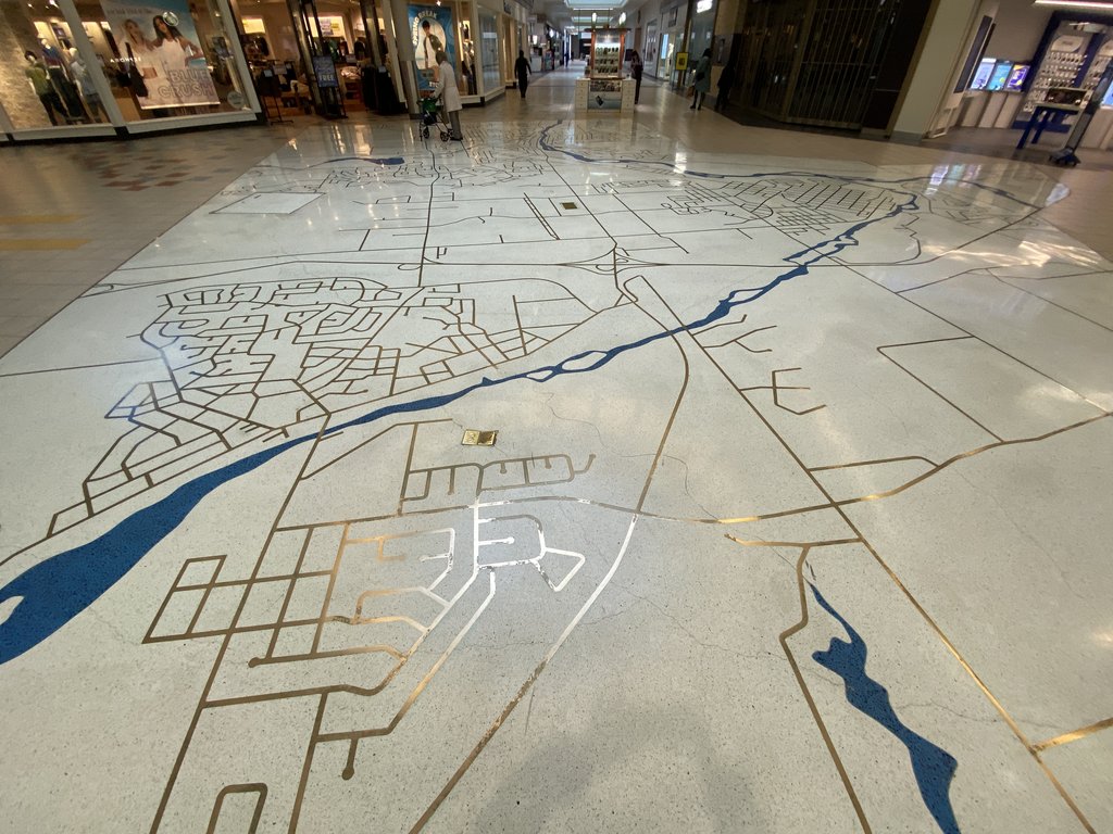
Was at the Cambridge Centre mall. As an angler and someone who very much appreciates rivers, especially beautiful ones like the Grand River, I love that they built this into the floor.

I couldn't tell what each community on this was supposed to be, but if I were a local I would know and would find it even cooler?

Reply With Quote
     
     
  #1545  
Old Posted Mar 28, 2024, 4:10 PM
ScreamingViking's Avatar
ScreamingViking ScreamingViking is offline
Ham-burgher
 
Join Date: Jun 2013
Location: Hamilton
Posts: 7,493
This angle is basically looking toward the south from a point north of Cambridge. So Hespeler is in the foreground bisected by the Speed River, Preston is farther back on the right where the Speed curves to meet the Grand River, and Galt is in the background. The 401 cuts across left-right and that bigger interchange is the one at Hespeler Rd./Hwy 24, with the Franklin Blvd. partial IC to its left.

Quote:
Originally Posted by megadude View Post
Was at the Cambridge Centre mall. As an angler and someone who very much appreciates rivers, especially beautiful ones like the Grand River, I love that they built this into the floor.

I couldn't tell what each community on this was supposed to be, but if I were a local I would know and would find it even cooler?

Reply With Quote
     
     
  #1546  
Old Posted Mar 28, 2024, 4:22 PM
megadude megadude is offline
Registered User
 
Join Date: Sep 2017
Location: N. York/Bram/Mark/Sauga/Burl/Oak/DT
Posts: 3,681
Quote:
Originally Posted by ScreamingViking View Post
This angle is basically looking toward the south from a point north of Cambridge. So Hespeler is in the foreground bisected by the Speed River, Preston is farther back on the right where the Speed curves to meet the Grand River, and Galt is in the background. The 401 cuts across left-right and that bigger interchange is the one at Hespeler Rd./Hwy 24, with the Franklin Blvd. partial IC to its left.
That's some good geographying there!
Reply With Quote
     
     
  #1547  
Old Posted Aug 28, 2024, 5:39 AM
MonkeyRonin's Avatar
MonkeyRonin MonkeyRonin is online now
¥ ¥ ¥
 
Join Date: Sep 2006
Location: Vancouver
Posts: 10,663
__________________
Reply With Quote
     
     
  #1548  
Old Posted Aug 28, 2024, 6:24 AM
Architype's Avatar
Architype Architype is online now
♒︎ verified human
 
Join Date: Mar 2004
Location: 🍁 Canada
Posts: 14,073
Quote:
Originally Posted by MonkeyRonin View Post
Vancouver, 1877:
Interesting, there was only Granville and Hastings, and what we commonly think of as the oldest neighborhoods, Strathcona, Mt. Pleasant, and West End weren't even there yet, but expansion was rapid soon after this. I don't think the Hastings area has any historic buildings today either, so maybe it wasn't even developed.
Reply With Quote
     
     
  #1549  
Old Posted Aug 28, 2024, 2:03 PM
MolsonExport's Avatar
MolsonExport MolsonExport is online now
Touching grass everyday.
 
Join Date: Oct 2003
Location: Otisburgh
Posts: 51,635
Wasn't nearby New Westminster laid down decades before Vancouver?

New West, 1865
__________________
The whole problem with the world is that fools and fanatics are always so certain of themselves, and wiser people so full of doubts. (Bertrand Russell). Sweet Loretta fart thought she was a cleaner, but she was a frying pan. (John Lennon)
Reply With Quote
     
     
  #1550  
Old Posted Jun 15, 2025, 12:14 PM
megadude megadude is offline
Registered User
 
Join Date: Sep 2017
Location: N. York/Bram/Mark/Sauga/Burl/Oak/DT
Posts: 3,681
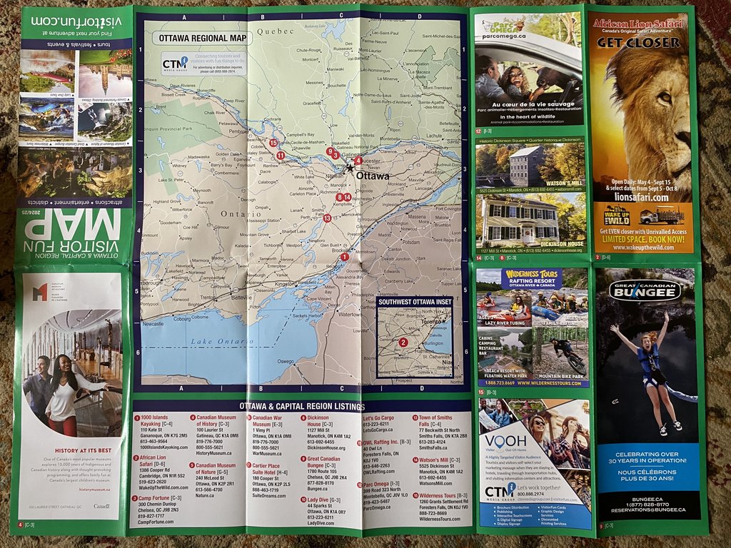
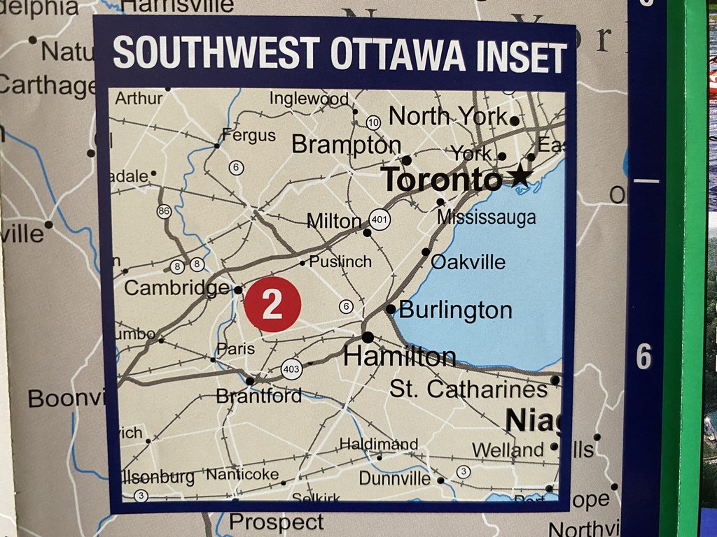
Wowwwww! Ottawa really going crazy with the amalgamations! Look out Mongol, Roman and British empires!


Reply With Quote
     
     
  #1551  
Old Posted Jun 15, 2025, 8:14 PM
MonkeyRonin's Avatar
MonkeyRonin MonkeyRonin is online now
¥ ¥ ¥
 
Join Date: Sep 2006
Location: Vancouver
Posts: 10,663
"Southwest Ottawa". Love it.


Quote:
Originally Posted by Architype View Post
Interesting, there was only Granville and Hastings, and what we commonly think of as the oldest neighborhoods, Strathcona, Mt. Pleasant, and West End weren't even there yet, but expansion was rapid soon after this. I don't think the Hastings area has any historic buildings today either, so maybe it wasn't even developed.
Pretty crazy that this was taken only 30 years later:

• Video Link
__________________
Reply With Quote
     
     
  #1552  
Old Posted Jun 15, 2025, 11:17 PM
Beedok Beedok is offline
Exiled Hamiltonian Gal
 
Join Date: Jun 2012
Posts: 6,797
Quote:
Originally Posted by megadude View Post
Wowwwww! Ottawa really going crazy with the amalgamations! Look out Mongol, Roman and British empires!


As a Hamiltonian living in Ottawa... better to be South West Ottawa than South West Toronto.
Reply With Quote
     
     
  #1553  
Old Posted Jun 16, 2025, 1:43 AM
FactaNV FactaNV is offline
Registered User
 
Join Date: Sep 2023
Posts: 2,378
Is it ever insane how big Ottawa's boundaries are. There is zero reason Ottawa and rural fields 35km from the core should have the same municipal government.
Reply With Quote
     
     
  #1554  
Old Posted Jun 16, 2025, 3:00 AM
megadude megadude is offline
Registered User
 
Join Date: Sep 2017
Location: N. York/Bram/Mark/Sauga/Burl/Oak/DT
Posts: 3,681
Quote:
Originally Posted by FactaNV View Post
Is it ever insane how big Ottawa's boundaries are. There is zero reason Ottawa and rural fields 35km from the core should have the same municipal government.
Yeah, doesn't feel right like how Stoney Creek, Glanbrook, Flamboro, Ancaster and Dundas were absorbed into Hamilton. There's parts of Dundas and Ancaster I go through that feel like they seamlessly blend into Hamilton but the outer parts are rural and very much feel like they should be something other than Hamilton. When I'm somewhere off of Hwy. 6 or Hwy. 8 north of Hamilton the city, as I often am when fishing or going to the Rockton Fair for example, in no way shape or form do I feel like this should be Hamilton.

Of course, these places are technically in Hamilton but can in some ways just be viewed as still being a part of the former Region of Hamilton-Wentworth. Or can kind of be viewed like in other countries where there's a major city and the surrounding state or province has the same name. However, when it comes to much of the administrative stuff, these places function one and the same as Hamilton, Hamilton. But they still have their own identities for those old enough to remember.

And, I've seen the signs the past two weeks just north of Barrie saying STOP ANNEXATION. Barrie is planning on annexing some lands from Springwater and Oro-Medonte.


Seriously though, how did anyone think that African Lion Safari was in any way close to the Ottawa region. And how did anyone not notice the inset map showing places like Toronto and Hamilton. Makes me think the brochure was farmed out abroad for a cheaper deal. But someone had to view the final product before it hit the shelves. I got it from a Budget rental car in Burlington. Hopefully someone noticed it later and only a small batch got out but then again there's so many people who just don't care and let these kinds of things get through. They might all have this error. I mean, last summer I signed up my daughter to Oakville Soccer and they gave her a 10-12 jersey. She was 5 years old and small for that age. It was a tent. It was in US sizes. The Oakville people told me they switched suppliers and ordered 30,000 lbs of gear from New Jersey without even seeing a sample product. They told them the measurements of their existing gear and just trusted they'd get the same thing. They said after that debacle they were sending a contingent down to the factory for this year's batch. I don't know how you could possibly commit to an order like that, especially coming from so close, and not view some samples first. It was wrong sizing for all age groups and staff.

Last edited by megadude; Jun 16, 2025 at 3:10 AM.
Reply With Quote
     
     
  #1555  
Old Posted Jun 16, 2025, 5:03 AM
Changing City's Avatar
Changing City Changing City is online now
Registered User
 
Join Date: Nov 2016
Posts: 8,308
Quote:
Originally Posted by Architype View Post
Interesting, there was only Granville and Hastings, and what we commonly think of as the oldest neighborhoods, Strathcona, Mt. Pleasant, and West End weren't even there yet, but expansion was rapid soon after this. I don't think the Hastings area has any historic buildings today either, so maybe it wasn't even developed.
Only Granville and Hastings had names, but they weren't the only developed parts of the Inlet. New Westminster was a modest town with a military foundation in 1858 as the capital of the Colony of British Columbia.

There was an earlier settlement when Fort Langley was initially established in 1827 in present-day Derby as a Hudson's Bay Company trading post. That site flooded, so the fort was later relocated to present-day location in 1839. The new fort was rebuilt in the following year, after a fire, and continued to be operated by the Hudson's Bay Company until 1886.

Hastings Mill (which was located between Granville and Hastings) had been developed in 1865, and you can see what it looked like by the end of the 1860s here. Initially its owner, Edward Stamp, had started building the mill closer to the First Narrows (close to where the Lion's Gate Bridge is now located), but the tides kept pulling ships from their moorings, so he moved it east, further into the Inlet.

Hastings Townsite was selected by the same British Royal Engineer who established New Westminster, Col. Moody, around 1863. It was at the end of an existing first nations trail that cut through the forest to reach Burrard Inlet. Oliver Hocking was Deputy Collector of Customs at Burrard Inlet from 1866 to 1869, leased the land, and erected buildings that included a post office and a hotel. Hocking called his development 'New Brighton', but when he sold the hotel to Maxie Michaud (who claimed to have walked there from Montreal) in 1869, Michaud renamed it the Hastings Hotel.

There was sometimes a ferry across to the other (earlier) mill and small settlement on the north shore, Moody's Mill, built in 1862, and bought out of bankrupcy by an American, Sewell Moody, in 1865. (He wasn't a relation to the British military officer).

Granville was developed, initially with a bar built on a clearing in a grove of maple trees by a New Westminster publican and sometimes Fraser River steamboat pilot, Jack Deighton, in 1867. He selected the location because it was just outside the mill lot boundary. He squatted initially, but was later allowed to build a new bar and hotel after the street grid had been surveyed - his first building was located (by the surveyor) in the middle of an intersection, so he couldn't continue to squat there.

Granville was renamed Vancouver when it was chosen as the terminus for the railway, but was almost totally destroyed by fire in 1886, and was rebuilt along with new suburbs including Strathcona, Mt. Pleasant, and the West End, in a very short time. The Hastings Hotel didn't burn down, but it was also rebuilt in 1886 so there are no earlier structures than 1886.

__________________
Contemporary Vancouver development blog, https://changingcitybook.wordpress.com/ Then and now Vancouver blog https://changingvancouver.wordpress.com/

Last edited by Changing City; Jun 16, 2025 at 5:20 AM.
Reply With Quote
     
     
  #1556  
Old Posted Jun 16, 2025, 5:37 AM
Loco101's Avatar
Loco101 Loco101 is offline
Registered User
 
Join Date: May 2013
Location: Timmins, Northern Ontario
Posts: 9,016
Quote:
Originally Posted by megadude View Post
Yeah, doesn't feel right like how Stoney Creek, Glanbrook, Flamboro, Ancaster and Dundas were absorbed into Hamilton. There's parts of Dundas and Ancaster I go through that feel like they seamlessly blend into Hamilton but the outer parts are rural and very much feel like they should be something other than Hamilton. When I'm somewhere off of Hwy. 6 or Hwy. 8 north of Hamilton the city, as I often am when fishing or going to the Rockton Fair for example, in no way shape or form do I feel like this should be Hamilton.
Ontario has all sorts of types of municipalities and some are just gigantic. Timmins where I live is about three times the size in area of the current City of Hamilton. Timmins was the first amalgamated city with a huge land area in the province and it was done in 1973 by the Ontario government. I can fish and hunt in my city and be in remote areas without any other people around and quite a ways from any road. Logging and mining are done in many places within the city. There are two provincial parks and more lakes and rivers than I can count.
Reply With Quote
     
     
  #1557  
Old Posted Jun 16, 2025, 8:39 AM
megadude megadude is offline
Registered User
 
Join Date: Sep 2017
Location: N. York/Bram/Mark/Sauga/Burl/Oak/DT
Posts: 3,681
Quote:
Originally Posted by Loco101 View Post
Ontario has all sorts of types of municipalities and some are just gigantic. Timmins where I live is about three times the size in area of the current City of Hamilton. Timmins was the first amalgamated city with a huge land area in the province and it was done in 1973 by the Ontario government. I can fish and hunt in my city and be in remote areas without any other people around and quite a ways from any road. Logging and mining are done in many places within the city. There are two provincial parks and more lakes and rivers than I can count.
Do you feel that there is some resentment from older folks who remember that from back then? Like does anyone even mention it? I'm sure there are plenty of people who specify they are from xyz former town, but is there actually resentment from technically having to live in Timmins?

I'm pretty sure a lot of Dundas and Ancaster people would never get caught saying they live in Hamilton. And as 🞵🞵🞵🞵🞵🞵 as Brampton is, especially compared to its neighbour and Peel Region brethren, I would never have wanted it to be absorbed by or amalgamated with Mississauga.

I also grew up in North York before moving to Brampton when I was almost eight. On the opposite side, I don't recall much fuss from NY, Scarboro, Etobicoke, York or East York folks about being merged into Toronto itself in 1997. It always felt like to me they were never actual cities themselves like they were, but rather burroughs like The Bronx, Brooklyn, Queens and Staten Island. Someone correct me if I'm wrong, but I don't recall there being distinct, organic Downtowns/main streets for those places.
Reply With Quote
     
     
  #1558  
Old Posted Jun 16, 2025, 2:07 PM
MolsonExport's Avatar
MolsonExport MolsonExport is online now
Touching grass everyday.
 
Join Date: Oct 2003
Location: Otisburgh
Posts: 51,635
NYCC was an attempt to create a separate downtown for North York, championed by none other than Mel "cooking pot" Lastman ("Nooooobodeeeeeeee....!").

• Video Link


Is it North York City Centre, or is it SimCity 3000?
__________________
The whole problem with the world is that fools and fanatics are always so certain of themselves, and wiser people so full of doubts. (Bertrand Russell). Sweet Loretta fart thought she was a cleaner, but she was a frying pan. (John Lennon)
Reply With Quote
     
     
  #1559  
Old Posted Jun 16, 2025, 2:58 PM
MonctonRad's Avatar
MonctonRad MonctonRad is offline
Wildcats Rule!!
 
Join Date: Jun 2008
Location: Moncton NB
Posts: 41,277
Quote:
Originally Posted by FactaNV View Post
Is it ever insane how big Ottawa's boundaries are. There is zero reason Ottawa and rural fields 35km from the core should have the same municipal government.
If you think this is bad, you should check out Halifax Regional Municipality (HRM).

On the eastern end, you enter HRM after passing through the sleepy fishing hamlet of Eecum Seecum on the way to Neecum Teuch. This is followed by a two hour drive through a wilderness predominated by barren seascapes, rocky outcropping, scraggly spruce trees and the odd dilapidated wharf before any hints of civilization appear on the horizon.

HRM is physically larger than PEI.
__________________
Go 'Cats Go
Reply With Quote
     
     
  #1560  
Old Posted Jun 16, 2025, 5:02 PM
someone123's Avatar
someone123 someone123 is online now
hähnchenbrüstfiletstüc
 
Join Date: Nov 2001
Location: Vancouver
Posts: 35,972
Quote:
Originally Posted by MonctonRad View Post
On the eastern end, you enter HRM after passing through the sleepy fishing hamlet of Eecum Seecum on the way to Neecum Teuch. This is followed by a two hour drive through a wilderness predominated by barren seascapes, rocky outcropping, scraggly spruce trees and the odd dilapidated wharf before any hints of civilization appear on the horizon..
I think the point of it was that those areas are so sparsely populated they couldn't easily maintain their own county-level government. It is a bit like how Vancouver includes some large mountainous areas, or how many small towns include large rural districts. Sable Island is also included in HRM for administrative purposes. HRM is a county-level government and the province is fully divided into counties.

HRM also has community councils and some powers are devolved to them.
Reply With Quote
     
     
This discussion thread continues

Use the page links to the lower-right to go to the next page for additional posts
 
 
Reply

Go Back   SkyscraperPage Forum > Regional Sections > Canada
Forum Jump


Forum Jump


All times are GMT. The time now is 8:54 PM.


Powered by vBulletin® Version 3.8.7
Copyright ©2000 - 2026, vBulletin Solutions, Inc.