HomeDiagramsDatabaseMapsForum About
     

Go Back   SkyscraperPage Forum > Regional Sections > Canada > Ontario > Ottawa-Gatineau > Transportation


Reply

 
Thread Tools Display Modes
     
     
  #3381  
Old Posted Dec 23, 2023, 5:40 AM
lrt's friend lrt's friend is offline
Registered User
 
Join Date: Dec 2006
Posts: 12,766
Latest observations:

1. a rail car full of ballast has been present in the last few days just north of Greenboro Station on the siding heading to the maintenance facility.
2. Leitrim Station is progressing. The old parking lot has been closed, and the one car using the park n ride today was in the new parking lot.
3. There are two MUPs at Bowesville Station (as per plan), one just south of the station and the other following Earl Armstrong Road. Both terminate at Bowesville Road and don't run to Riverside South. Going the other way, the MUP will go to South Keys and connect to the Sawmill Creek trail. I guess the park n ride at Bowesville will serve both transit riders and cyclists. The lack of a MUP running between Bowesville and Limebank must have been a cost cutting measure.
4. Construction has begun on a housing development right at the corner of Limebank and Earl Armstrong, but there will be no direct sidewalk to Limebank Station along Limebank. The sidewalk will be further west, which may work well depending on how pedestrian accesses work within the new housing development.
5. There were no trains on the track at any of the south end stations at Noon today. I realize that most testing happens at night, but sometimes the trains are parked at various stations.

Last edited by lrt's friend; Dec 23, 2023 at 5:50 AM.
Reply With Quote
     
     
  #3382  
Old Posted Jan 1, 2024, 3:44 PM
SL123 SL123 is offline
Registered User
 
Join Date: Mar 2021
Posts: 1,943
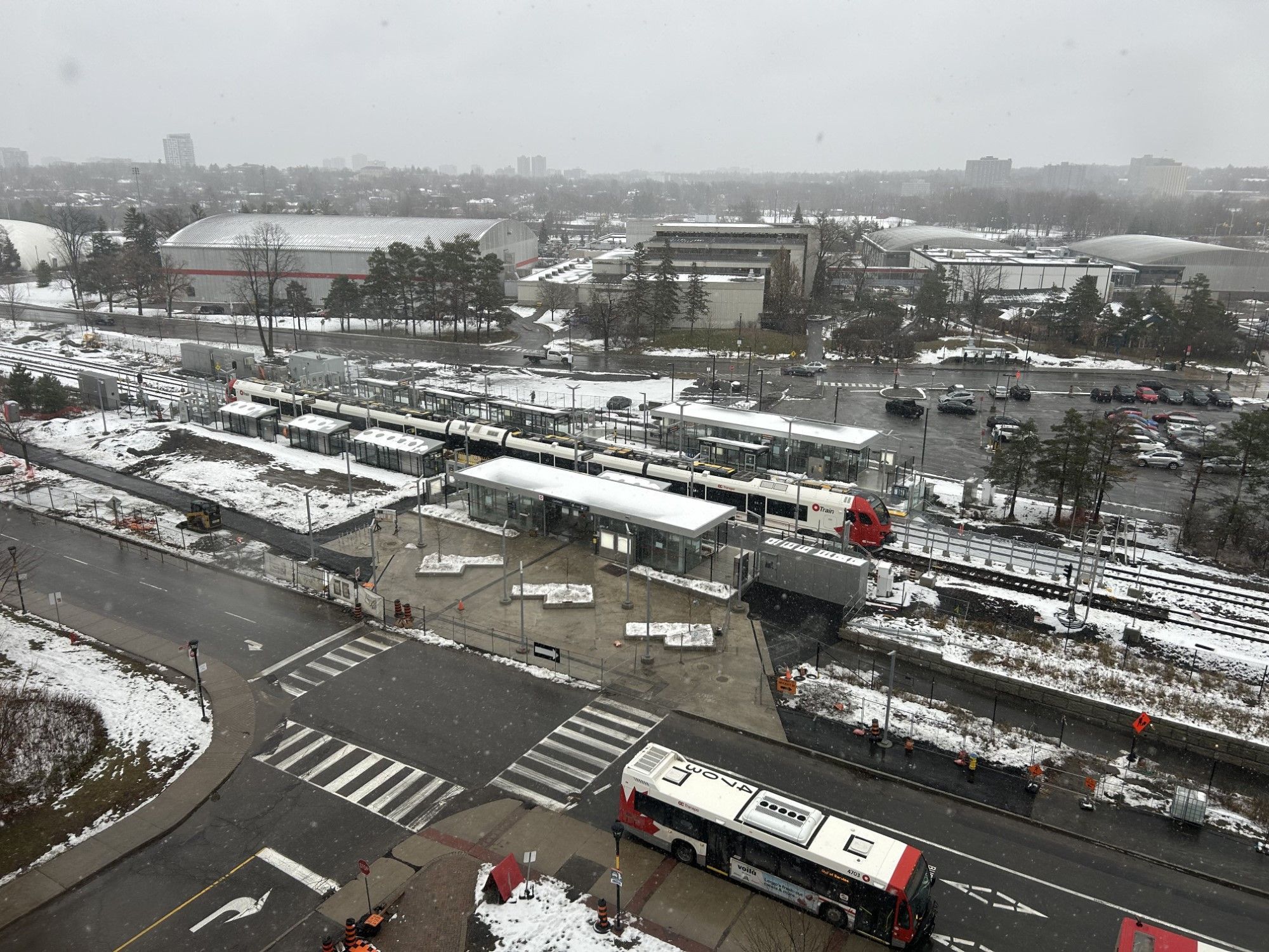
There's a lot of new update pics on Rail Fans Canada's website for the Trillium Line
https://otrain.railfans.ca/snapshot

Looks like they've built a plaza with planters in front of Carleton Station.

(credit: Rail Fans Canada)
Reply With Quote
     
     
  #3383  
Old Posted Jan 1, 2024, 5:12 PM
lrt's friend lrt's friend is offline
Registered User
 
Join Date: Dec 2006
Posts: 12,766
Very recently, they took down the fences in front of Walkley Station.
Reply With Quote
     
     
  #3384  
Old Posted Jan 2, 2024, 1:21 PM
daud's Avatar
daud daud is offline
Registered User
 
Join Date: Jun 2012
Location: Ottawa
Posts: 762
Quote:
Originally Posted by lrt's friend View Post
Latest observations:

4. Construction has begun on a housing development right at the corner of Limebank and Earl Armstrong, but there will be no direct sidewalk to Limebank Station along Limebank. The sidewalk will be further west, which may work well depending on how pedestrian accesses work within the new housing development.
Which corner? I know there's a mini mall and small office going up on the northwest corner of Limebank and Earl Armstrong. Apparently with a mcDonalds which, while completely underwhelming from a development perspective, it is going to be very welcome in that neighbourhood.

They seem to be doing some work on the south east corner-Is that going to be residential?
Reply With Quote
     
     
  #3385  
Old Posted Jan 2, 2024, 5:10 PM
vtecyo vtecyo is offline
Registered User
 
Join Date: Feb 2015
Posts: 328
Quote:
Originally Posted by lrt's friend View Post
Latest observations:

...
4. Construction has begun on a housing development right at the corner of Limebank and Earl Armstrong, but there will be no direct sidewalk to Limebank Station along Limebank. The sidewalk will be further west, which may work well depending on how pedestrian accesses work within the new housing development.
...
At the north west corner? Unfortunately it's not housing or high density - despite being in the "town centre" (as the city has designated the area around the station) - it's suburban car focused retail. On the bright side - the buildings will probably be cheaply made, and easy to tear down when they are eventually replaced with something that makes long term sense. https://skyscraperpage.com/forum/showthread.php?p=9775101#post9775101 , https://devapps.ottawa.ca/en/applications/D07-12-22-0169/details, https://www.urbandalecorporation.com/retail/armstrong-plaza,

Last edited by vtecyo; Jan 2, 2024 at 5:21 PM. Reason: grammar
Reply With Quote
     
     
  #3386  
Old Posted Jan 2, 2024, 7:22 PM
lrt's friend lrt's friend is offline
Registered User
 
Join Date: Dec 2006
Posts: 12,766
Quote:
Originally Posted by vtecyo View Post
At the north west corner? Unfortunately it's not housing or high density - despite being in the "town centre" (as the city has designated the area around the station) - it's suburban car focused retail. On the bright side - the buildings will probably be cheaply made, and easy to tear down when they are eventually replaced with something that makes long term sense. https://skyscraperpage.com/forum/showthread.php?p=9775101#post9775101 , https://devapps.ottawa.ca/en/applications/D07-12-22-0169/details, https://www.urbandalecorporation.com/retail/armstrong-plaza,
You are right. Your comment prompted me to take a little drive out there. A sign has now been erected that the northwest corner will be a retail plaza. There is no work on the other three corners yet and I know at least one of those quadrants will be residential. Nevertheless, with development now reaching the Earl Armstrong/Limebank intersection, I guarantee pedestrians will approach Limebank Station along Limebank Road even if there is no sidewalk. But the experts always know best by placing a sidewalk a few hundred metres to the west. Local residents will agree or disagree very quickly.

Last edited by lrt's friend; Jan 2, 2024 at 7:44 PM.
Reply With Quote
     
     
  #3387  
Old Posted Jan 2, 2024, 7:43 PM
lrt's friend lrt's friend is offline
Registered User
 
Join Date: Dec 2006
Posts: 12,766
My little tour has me a little confused and frustrated with plans.

I have noticed and commented about this before but it still bugs me about the MUPs following the Trillium Line extensions. We are spending a lot of money to build MUPs along the Trillium Line but their termination points are disturbing as the trails don't go to the most useful locations. They do not serve the community well at all. They terminate in nothingness. One of the MUPs terminates at the Airport Parkway. What a useless location. Why did it not run slightly west to Uplands Drive, so that it would serve the EY Centre. Another issue is how these MUPs cross busy roadways at grade instead crossing the newly built railway bridges. Will this not be a safety issue going forward especially with the bridges themselves causing visual obstruction for motorists? I walked around South Keys Station and was confused how the MUPs were going to connect to the station and to the Sawmill Creek trail running to the north. It was really unclear how the MUPs along the main line and the airport spur (which are on the opposite sides of the tracks, the main line MUP on the east side and the airport spur MUP on the west side) were going to cross Hunt Club and reach the station. I looked at both sides of South Keys station and I didn't get it. Perhaps someone else knows the answer. I hope we aren't expected to cross Hunt Club Road at grade, an awful location for pedestrians and cyclists. I also noticed that paving of the MUP has been completed as far as Lester Road but certainly not at the South Keys end.

They have opened up South Keys Station so you can see inside. Funny thing, the door was open a little bit so I could have snuck in, but I didn't. The fare gates are there but not fully installed. The next train/bus displays are up but not operational and the ticket machines are there but still covered. Even though South Keys is the only access to the airport train, there is no escalator to the platform. Two elevators and stairs. Not ideal for a major transfer station and as I said, the only station accessing the airport train. I also noticed that the rail platform signs are operational and the display is in colour, not monochrome like the Confed Line next train signage.

Last edited by lrt's friend; Jan 2, 2024 at 8:03 PM.
Reply With Quote
     
     
  #3388  
Old Posted Jan 2, 2024, 8:44 PM
vtecyo vtecyo is offline
Registered User
 
Join Date: Feb 2015
Posts: 328
Quote:
Originally Posted by lrt's friend View Post
My little tour has me a little confused and frustrated with plans.

I have noticed and commented about this before but it still bugs me about the MUPs following the Trillium Line extensions. We are spending a lot of money to build MUPs along the Trillium Line but their termination points are disturbing as the trails don't go to the most useful locations. They do not serve the community well at all. They terminate in nothingness. One of the MUPs terminates at the Airport Parkway. What a useless location. Why did it not run slightly west to Uplands Drive, so that it would serve the EY Centre. Another issue is how these MUPs cross busy roadways at grade instead crossing the newly built railway bridges. Will this not be a safety issue going forward especially with the bridges themselves causing visual obstruction for motorists? I walked around South Keys Station and was confused how the MUPs were going to connect to the station and to the Sawmill Creek trail running to the north. It was really unclear how the MUPs along the main line and the airport spur (which are on the opposite sides of the tracks, the main line MUP on the east side and the airport spur MUP on the west side) were going to cross Hunt Club and reach the station. I looked at both sides of South Keys station and I didn't get it. Perhaps someone else knows the answer. I hope we aren't expected to cross Hunt Club Road at grade, an awful location for pedestrians and cyclists. I also noticed that paving of the MUP has been completed as far as Lester Road but certainly not at the South Keys end.

They have opened up South Keys Station so you can see inside. Funny thing, the door was open a little bit so I could have snuck in, but I didn't. The fare gates are there but not fully installed. The next train/bus displays are up but not operational and the ticket machines are there but still covered. Even though South Keys is the only access to the airport train, there is no escalator to the platform. Two elevators and stairs. Not ideal for a major transfer station and as I said, the only station accessing the airport train. I also noticed that the rail platform signs are operational and the display is in colour, not monochrome like the Confed Line next train signage.
As for South Keys - it looks like the MUP is meant to cross above Hunt Club on rail bridge - at least it says so on this page - you have to scroll quite far down to find it: https://ottawa.ca/en/city-hall/public-en...t-station-connectivity-enhancement-study

As for the rest - I've never been able to find detailed designs of the pathways. I always get the impression the city makes up MUP designs as they go, at least when not part of a road rebuild. For whatever reason they don't feel the need to do much more than draw a few vague lines on a map - at least as far as what they show the public.
Reply With Quote
     
     
  #3389  
Old Posted Jan 2, 2024, 9:14 PM
lrt's friend lrt's friend is offline
Registered User
 
Join Date: Dec 2006
Posts: 12,766
Quote:
Originally Posted by vtecyo View Post
As for South Keys - it looks like the MUP is meant to cross above Hunt Club on rail bridge - at least it says so on this page - you have to scroll quite far down to find it: https://ottawa.ca/en/city-hall/public-en...t-station-connectivity-enhancement-study

As for the rest - I've never been able to find detailed designs of the pathways. I always get the impression the city makes up MUP designs as they go, at least when not part of a road rebuild. For whatever reason they don't feel the need to do much more than draw a few vague lines on a map - at least as far as what they show the public.
Thank you for sharing. I have seen that report before but still leaves me puzzled when looking at the overall MUP project. This report only addresses stations not the locations between stations.

When I was at South Keys today, I specifically went to look at the east side of the rail line as my memory told me that the MUP would enter there, and this is what the report says. But there is very little space between the bus platforms and the the rail tracks. Where does the MUP enter the station and how does it connect with the Sawmill Creek MUP which is on the west side of the station? Do cyclists enter directly onto the bus platforms where people are waiting for buses? This does not seem safe. There is new MUP pavement on the west side of the station heading towards Hunt Club but as suggested by the plan, there is no space to cross the rail bridge there. I am not sure where this is heading at all. Then the MUP that ends at the Airport Parkway on the west side of the rail line. How does this reach South Keys, if the Hunt Club crossing is on the east side of the rail bridge? Is there some cross over somewhere south of Hunt Club? As I said, I am confused how any of this works, and if it will actually be effective. My impressions are that South Keys will be a bit of a mess. Cyclists will not be able to easily ride through the station. It will be dismount, and use stairs or an elevator. And beware of all the transit riders. Yuck!

Reply With Quote
     
     
  #3390  
Old Posted Jan 3, 2024, 2:51 AM
vtecyo vtecyo is offline
Registered User
 
Join Date: Feb 2015
Posts: 328
Quote:
Originally Posted by lrt's friend View Post
Thank you for sharing. I have seen that report before but still leaves me puzzled when looking at the overall MUP project. This report only addresses stations not the locations between stations.

When I was at South Keys today, I specifically went to look at the east side of the rail line as my memory told me that the MUP would enter there, and this is what the report says. But there is very little space between the bus platforms and the the rail tracks. Where does the MUP enter the station and how does it connect with the Sawmill Creek MUP which is on the west side of the station? Do cyclists enter directly onto the bus platforms where people are waiting for buses? This does not seem safe. There is new MUP pavement on the west side of the station heading towards Hunt Club but as suggested by the plan, there is no space to cross the rail bridge there. I am not sure where this is heading at all. Then the MUP that ends at the Airport Parkway on the west side of the rail line. How does this reach South Keys, if the Hunt Club crossing is on the east side of the rail bridge? Is there some cross over somewhere south of Hunt Club? As I said, I am confused how any of this works, and if it will actually be effective. My impressions are that South Keys will be a bit of a mess. Cyclists will not be able to easily ride through the station. It will be dismount, and use stairs or an elevator. And beware of all the transit riders. Yuck!

After digging through Geo Ottawa's layers for cycling info - it looks like there's two different routes shown. One is on the west side of the tracks and one on the east. I assume the west side one is the old plan. The east side route will require people to turn around after crossing the bridge - go back down towards Hunt Club - and then back north again. It could be worse, at least it's grade separated.

Side note - it's laughable that the red lines in that data layer indicate existing cycling routes - on the road on Hunt Club and the Airport Parkway... no thanks.


Last edited by vtecyo; Jan 3, 2024 at 2:58 AM. Reason: more info
Reply With Quote
     
     
  #3391  
Old Posted Jan 3, 2024, 2:58 AM
lrt's friend lrt's friend is offline
Registered User
 
Join Date: Dec 2006
Posts: 12,766
Quote:
Originally Posted by vtecyo View Post
After digging through Geo Ottawa's layers for cycling info - it looks like there's two different routes shown. One is on the west side of the tracks and one on the east. I assume the west side one is the old plan. The east side route will require people to turn around after crossing the bridge - go back down towards Hunt Club - and then back north again. It could be worse, at least it's grade separated.

Interesting. Thanks for sharing. I should check out if this is what is evolving at South Keys and Hunt Club.
Reply With Quote
     
     
  #3392  
Old Posted Jan 3, 2024, 4:18 AM
LRTeverywhere LRTeverywhere is offline
Registered User
 
Join Date: Oct 2018
Posts: 326
Quote:
Originally Posted by lrt's friend View Post
We are spending a lot of money to build MUPs along the Trillium Line but their termination points are disturbing as the trails don't go to the most useful locations. They do not serve the community well at all. They terminate in nothingness. One of the MUPs terminates at the Airport Parkway. What a useless location. Why did it not run slightly west to Uplands Drive, so that it would serve the EY Centre.
There is no mup running along the airport branch of the line, that pavement you see that ends at the airport parkway is simply an access road for a electrical transformer and propane tank.
Reply With Quote
     
     
  #3393  
Old Posted Jan 3, 2024, 5:04 AM
lrt's friend lrt's friend is offline
Registered User
 
Join Date: Dec 2006
Posts: 12,766
Quote:
Originally Posted by LRTeverywhere View Post
There is no mup running along the airport branch of the line, that pavement you see that ends at the airport parkway is simply an access road for a electrical transformer and propane tank.
Thank you for the clarification. Much appreciated.
Reply With Quote
     
     
  #3394  
Old Posted Jan 3, 2024, 11:19 PM
qprcanada qprcanada is online now
Registered User
 
Join Date: Apr 2018
Posts: 144
I noticed tonight when walking my dog in the Arboretum that the scaffolding has been removed from around the tunnel ventilation building. Additionally the temporary stairs that the workers were using to access the tunnel have been removed at the north end of the tunnel entrance.
Reply With Quote
     
     
  #3395  
Old Posted Jan 15, 2024, 8:18 PM
lrt's friend lrt's friend is offline
Registered User
 
Join Date: Dec 2006
Posts: 12,766
First sighting for me a short time ago. A Flirt train at South Keys with a Lint train in the pocket track.
Reply With Quote
     
     
  #3396  
Old Posted Jan 23, 2024, 3:26 PM
J.OT13's Avatar
J.OT13 J.OT13 is offline
Moderator
 
Join Date: Mar 2012
Location: Ottawa
Posts: 28,741
Reply With Quote
     
     
  #3397  
Old Posted Jan 24, 2024, 8:31 PM
lrt's friend lrt's friend is offline
Registered User
 
Join Date: Dec 2006
Posts: 12,766
I spotted two linked LINT trains at South Keys Station at lunch time today.
Reply With Quote
     
     
  #3398  
Old Posted Jan 24, 2024, 10:16 PM
Uhuniau Uhuniau is online now
Registered User
 
Join Date: Jan 2010
Posts: 9,025
Quote:
Originally Posted by SL123 View Post
There's a lot of new update pics on Rail Fans Canada's website for the Trillium Line
https://otrain.railfans.ca/snapshot
Looks like they've built a plaza with planters in front of Carleton Station.
(credit: Rail Fans Canada)
I would have sacrificed every cent spent on that plaza and planters and devoted it to an actual, sensible, shelter structure at this duct-taped jerry-rigged excuse of a station.
__________________
___
Enjoy my taxes, Orleans (and Kanata?).
Reply With Quote
     
     
  #3399  
Old Posted Jan 24, 2024, 11:01 PM
DTcrawler DTcrawler is offline
Registered User
 
Join Date: Feb 2019
Location: Ottawa
Posts: 998
Quote:
Originally Posted by Uhuniau View Post
I would have sacrificed every cent spent on that plaza and planters and devoted it to an actual, sensible, shelter structure at this duct-taped jerry-rigged excuse of a station.
That, or the $50M the city is able to throw down to widen a whopping 2km of Bank St. in the boonies. Mix in the budgets of a few other suburban-pandering road project and we could've built an actual 21st century transit network fit for a city that experiences -40 to +40 temps.
Reply With Quote
     
     
  #3400  
Old Posted Jan 25, 2024, 7:35 PM
Uhuniau Uhuniau is online now
Registered User
 
Join Date: Jan 2010
Posts: 9,025
Quote:
Originally Posted by DTcrawler View Post
That, or the $50M the city is able to throw down to widen a whopping 2km of Bank St. in the boonies. Mix in the budgets of a few other suburban-pandering road project and we could've built an actual 21st century transit network fit for a city that experiences -40 to +40 temps.
A *network*? Woah, don't get too big for your britches! We can't even get very basic, small, and relatively cheap shelter amenities right and here you are wanting a whole-ass network?


I mean, I already know the reason why Carleton station sucks and will continue to suck, but has anyone in officialdom said that reason out loud, I wonder?
__________________
___
Enjoy my taxes, Orleans (and Kanata?).
Reply With Quote
     
     
This discussion thread continues

Use the page links to the lower-right to go to the next page for additional posts
 
 
Reply

Go Back   SkyscraperPage Forum > Regional Sections > Canada > Ontario > Ottawa-Gatineau > Transportation
Forum Jump


Forum Jump


All times are GMT. The time now is 3:58 PM.

     
SkyscraperPage.com - Privacy Statement - Top

Powered by vBulletin® Version 3.8.7
Copyright ©2000 - 2026, vBulletin Solutions, Inc.