HomeDiagramsDatabaseMapsForum About
     

Go Back   SkyscraperPage Forum > Regional Sections > Canada > Alberta & British Columbia > Calgary > Transportation & Infrastructure


Closed Thread

 
Thread Tools Display Modes
     
     
  #5261  
Old Posted Aug 2, 2012, 6:33 PM
fusili's Avatar
fusili fusili is offline
Retrofit Urbanist
 
Join Date: Sep 2007
Posts: 6,692
Quote:
Originally Posted by DarkKeyo View Post
If you ever want help with the map, keep in mind that I use Adobe Photoshop and Illustrator to make/edit maps for a living, and that I enjoy chances to do so without my paycheque depending on it.
I can send you the Illustrator file if you would like.
__________________
Not everything that can be counted counts, and not everything that counts can be counted.
     
     
  #5262  
Old Posted Aug 2, 2012, 6:39 PM
fusili's Avatar
fusili fusili is offline
Retrofit Urbanist
 
Join Date: Sep 2007
Posts: 6,692
Quote:
Originally Posted by DarkKeyo View Post
I like the basic ideas of this. I have ended up writing a rather long collection of comments, though...

I think your map could use some refinement, but I won't spend too much time on that. A bit of change in the colours (shades that are easy on the eye; possibly not using brown, instead silver or grey; “Magenta line or “Pink line” are a bit of a mouthful) and stations (should be more visible than a small black dot, maybe acircle with a thinner line than your inerchange stations) would go a long way towards providing a good example. You have missed the station on the NE line between Stoney and Skyview, and the station in Seton after South Hospital. As well, even though it makes it easier to fit the names in horizontally, I don't think the map should be compressed vertically as much as it is. Calgary is a very N-S city, so the more distorted the map is, the less it functions as a representation of the city.
I agree with having NW-S be blue and NE-W be red, as opposed to Calgary Transit's plans of having them the other way around.

Regarding the network itself, there are a few holes where some sort of crosstown connector could be used. There is no crosstown from the interchange station at Brentwood in the NW to anywhere in the North Central (maybe send it to Aurora Park interchange station; CT just introduced Route 8, and then upgraded it to all-day service, between those areas). The dashed blue line from Westbrook north is more important than other, more certain, parts of the network. And, in the previous Transitcamp map, a connection was provided from Rundle to the 52 St BRT/Magenta line. Some future ideas to consider would be connections between Woodbine, Anderson, and Douglasdale, as well as Bowness or Montgomery to Brentwood or Dalhousie.

I'm going to be a bit picky about station names. I see you have removed a lot of extra wording from the names. If you could convince Calgary Transit that this is a good idea, there are places where station names are unnecessarily long and complicated (eg. Somerset, Fish Creek, Bridgeland, possibly SAIT) and would be less confusing if made simpler. In other cases (Victorai Park Stampede, Erlton Stampede, Barlow Max Bell, Shaganappi Point, Saddletowne, possibly several of the SE stations where you cut the name in half) the station is made more confusing by omitting important information from the name. Expanding that idea to the BRT, all the hospitals should include the word 'Hospital' in the name, schools such as 'McNally' and 'Pearson' should have their full name, and so should the Genesis Centre. The station on the North Central LRT between Highland Park and Huntington shouldn't be called 'McKnight' even if it ends up anywhere near the road McKnight. I don't think Calgary has the right naming mentality for two McKnight stations. In cases where we are going to use the major road for the station name, 16th Ave N should be the transfer station and Crescent Heights the station south of it.

This plan by Transitcamp, and the Calgary Transit BRT plan that it is based on, are both good ideas, if you were to implement them as on-street BRT now, and expand to grede separated BRT later. In other words, it is a good plan for the core of a network. I was at Jarret Walker's presentation, and I agree with a grid of high frequency routes, and I agree more every time I go to central Vancovuer or Toronto and use their grid. This network shouldn't ever be thought of as everything we need, but should be thought of as the core of what we need right now. I wouldn't mind of Calgary Transit took some service hours from some of their more redundant suburban routes towards implementing these as on-street BRT, to test potential ridership of all these routes.

And finally, a pet peeve of mine, in the category of naming of stations, is when people put an apostrophe in Lions Park. Maybe because it's the station I use most often...
Awesome suggestions! Point taken regarding the station names (I was just lazy for some of them).

1st bolded point: I think a crosstown route from Brentwood to Highland to Rundle using Northmount/40th/32nd is totally viable. Just haven't added it yet.

Thanks for the feedback.
__________________
Not everything that can be counted counts, and not everything that counts can be counted.
     
     
  #5263  
Old Posted Aug 2, 2012, 8:23 PM
RyLucky's Avatar
RyLucky RyLucky is offline
Registered User
 
Join Date: Feb 2012
Posts: 2,498
Quote:
Originally Posted by fusili View Post
Thanks.

I am sure either myself or another TransitCamp member will post in the future about funding. I am more focused on network design, branding and implementation, but there are others who are more versed on the funding side of things.

Thanks for the suggestion.
Awesome!~
There are a few decent reviews out there, but I'd be interested to read what TransitCamp can come up with. Here are a couple good reads related the the economics of transit with some nice bits on Calgary:

Topalovic et al. 2012
http://www.eng.mcmaster.ca/civil/facultypages/krantz16.pdf

Hubbell and Colquhoun, 2004
http://www.calgarytransit.com/pdf/Calgarys_LRT_1st_25Years_TRB_revised.pdf

McKendrick, Colquhoun, Charles, Hubbell, 2005
http://www.calgarytransit.com/pdf/calgary_ctrain_effective_capital_utilization_TRB_paper.pdf

York Region, Best Practices Review, 2007
http://www.york.ca/NR/rdonlyres/mm574ixh...dikr5b/(IP)+TMP_Best+Practices_Apr07.pdf

Even in a city with a healthy economy and much-loved LRT system, we'll need some creative solutions in order to achieve building the infrastructure we need. [reposted from construction thread]
     
     
  #5264  
Old Posted Aug 3, 2012, 12:16 AM
andasen andasen is offline
Registered User
 
Join Date: Feb 2012
Location: Calgary
Posts: 227
Quote:
Originally Posted by fusili View Post
The newest TransitCamp blog: A Future Map for Calgary Transit?

http://transitcamp.ca/2012/08/02/a-future-map-for-calgary-transit/
I agree with the other reviewers that this map is very good fundementally though it needs refining.

Many great points have been brought up so I wont waste your time by repeating them, so this is a short addition to what has already been said.

To further the thoughts on distinguising exclusive ROW routes I'm thinking that outlining the lines may be the trick to drawing attention to them without diminishing the importance of the non-exclusive ROW routes.

Just a little nitpicking in the midsouth east area. You have the SW cross town running joining the SE line at Quarry Park then following it to Douglasglen Station (which is misnamed douglasdale FYI). I am inclined to agree that the line should end there but that the connection to quarry park station should be removed and instead have stops at Quarry Park Blvd and Douglasglen Blvd to better service the entire area. (this is assuming that the 302 will be on its ROW east of 24th)

I'm a fan of douglasglen being a major transfer point and though I am concerned that the neat connection of the 52nd BRT may have to be at Shepard instead if 52 St between 114th and 130th builds up at all.
     
     
  #5265  
Old Posted Aug 3, 2012, 2:21 AM
5seconds 5seconds is offline
Closed account
 
Join Date: Mar 2011
Posts: 935
I like the map. Keeping real geography to a minimum is a good idea. London figured that out in the 1930s, I think, and it works better with a 'circuit' style diagram. keep it simple!

Saying that, I think a small jog south from 50th ave SW to Heritage Park might be a good idea, just so that it's clear that HP is actually south of the hospital.

Other than that, any thoughts about a SWLRT line via the Tsuu T'ina, if that ever happens? Failing that, what about BRT service from Sirocco, south on Sarcee Trail, South on the SW Ring Road and into Providence, then east via the 162nd ROW and terminating at Somerset? I can't help but think that once (if?) the road goes in, that whole area will fill up, and bus service via 14th and the causeway isn't going to cut it, and I suspect either will getting people onto the SLRT.

I was also thinking that McKnight station name on the NCLRT might be confusing with the McKnight station on the NELRT.

Just some thoughts! I like it.

Last edited by 5seconds; Aug 3, 2012 at 3:13 AM.
     
     
  #5266  
Old Posted Aug 3, 2012, 3:22 AM
sim sim is offline
Registered User
 
Join Date: Aug 2008
Posts: 863
Quote:
Originally Posted by fusili View Post
This is exactly what rail bias is. You are saying rail is faster because it is more often grade separated. Well, that has nothing to do with rail and everything to do with grade separation. Buses on Bogota's Transmilenio move a lot faster than TTC streetcars.
I think you misunderstood me there, or I wasn't being clear. We are saying more or less the same thing. I am completely aware of both systems and this extends to virtually any in traffic street based rail system vs. a true BRT.

I am saying that in Calgary's case, rail is faster than the bus and according to peoples' deep-seeded understanding, this is often how it is perceived and in most cases, unless you are in one of the true BRT cities, true. This isn't "rail bias," this is just inherent to how most non-street rail-based systems have historically operated and been built. If this had and were the case for the majority of bus systems, then the perception would similarly be as such. However, this is not the case and only true BRT might be able to change that, of which none of those lines are. Hence, why I'm saying that the map has buried more useful information than it needs to.

But what I tried to convey in my anecdote is where the less quantifiable differences in utility create the apples to apples "rail bias," and where unless the BRT is completely delineated, not just in its ROW but in its infrastructure appearance (meaning I can stumble across the BRT ROW at any point and understand that a Public Transit vehicle is exclusively coming along there) rail has an advantage as I can intuitively know (with that corresponding utility) that I will likely have service there (due to the tracks.) This hasn't yet touched on the other minor differences, such as ride quality (which the best designed bus can not replicate (physics), or noise and comfort - which are not inherent to either technology, but is currently being won by rail (so long as they are continuously welded and nicely aligned.)

Given the choice between an equally loaded, equal travel time along the same OD between rail and bus, I would choose rail and the rail bias comes from the fact that the majority would do the same.

I'm not trying to be a "technology enthusiast" here, but to contend that there aren't any utility differences between the two, however minor is disregarding reality. With BRT and LRT (non-traffic going a la TTC,) controlled for frequency and speed, this may just be minor enough to not bother distinguishing the two on say a network map. However, for Calgary this is not the case and hence why I'm being rather adamant that that information remains conveyed to the end user as it remains important.
     
     
  #5267  
Old Posted Aug 3, 2012, 5:12 PM
DizzyEdge's Avatar
DizzyEdge DizzyEdge is offline
My Spoon Is Too Big
 
Join Date: Oct 2006
Location: Calgary
Posts: 9,162
I just wanted to comment a bit on the 'rail bias' part.

I'm not sure if this is your opinion, but the whole rail bias thing seems to often come across as though it is some sort of phenomenon when in reality it exists because almost every aspect of rail is better than the typical city bus. Rail tends to have: better infrastructure, smoother ride, smoother acceleration and deceleration, faster travel times (due to dedicated infrastructure).

It only takes a minute to sit on an LRT and observe the noise levels and smoothness, and then compare to a bus ride where every bump is harse and the entire structure of the bus is making a racket rattling to see how superior the rail ride is.

That said, I think buses could greatly close the gap with a proper BRT using existing buses which includes:
- enhanced infrastructure
- high quality maintained roadway
- lack of other traffic should reduce sudden deceleration
- driver education should reduce sudden acceleration
- dedicated roadway decreases travel time

As for the inferior suspension city buses seem to have as compared to even an average car, coach-style buses seem to be much closer in comfort level, both with seat padding and suspension. In the past I posted a double decker coach style bus used by BRTs elsewhere. If you could have smooth pavement, a coach style bus, and if that bus had CVT transmissions (does that exist?) you'd be 80%+ of the way there to rail feel.
__________________
Concerned about protecting Calgary's built heritage?
www.CalgaryHeritage.org
News - Heritage Watch - Forums
     
     
  #5268  
Old Posted Aug 3, 2012, 7:56 PM
andasen andasen is offline
Registered User
 
Join Date: Feb 2012
Location: Calgary
Posts: 227
Update on Chinook Station renovations!

Some conceptual drawings


  #5269  
Old Posted Aug 4, 2012, 6:51 AM
RyLucky's Avatar
RyLucky RyLucky is offline
Registered User
 
Join Date: Feb 2012
Posts: 2,498
Quote:
Originally Posted by andasen View Post
Update on Chinook Station renovations!
Do my eyes deceive me, or will we be able to board the Southbound train from either side?

Way to go for making the station more accessible!
     
     
  #5270  
Old Posted Aug 4, 2012, 3:52 PM
mersar's Avatar
mersar mersar is offline
Registered User
 
Join Date: May 2006
Location: Calgary, AB
Posts: 10,083
Quote:
Originally Posted by RyLucky View Post
Do my eyes deceive me, or will we be able to board the Southbound train from either side?

Way to go for making the station more accessible!
The shelter on the west side of the south platform is a bus shelter (if thats what you thought may have meant a platform on both sides), so nope, no dual sided boarding (though I admit it would be an interesting concept to use)

You can find some higher res copies of those images on the Calgary City News blog site here
__________________

Live or work in the Beltline? Check out the Official Beltline web site here
     
     
  #5271  
Old Posted Aug 5, 2012, 3:48 PM
RyLucky's Avatar
RyLucky RyLucky is offline
Registered User
 
Join Date: Feb 2012
Posts: 2,498
Quote:
Originally Posted by mersar View Post
The shelter on the west side of the south platform is a bus shelter (if thats what you thought may have meant a platform on both sides), so nope, no dual sided boarding (though I admit it would be an interesting concept to use)

You can find some higher res copies of those images on the Calgary City News blog site here
Thanks. That's way easier to see. It would have been nice to be able to step off the bus and onto a train... just like a real train station. Oh well, it's still a huge improvement.
     
     
  #5272  
Old Posted Aug 5, 2012, 5:48 PM
DarkKeyo DarkKeyo is offline
Transit/Cartography Geek
 
Join Date: May 2008
Location: Burnaby
Posts: 332
Quote:
Originally Posted by RyLucky View Post
Thanks. That's way easier to see. It would have been nice to be able to step off the bus and onto a train... just like a real train station. Oh well, it's still a huge improvement.
I'm curious as to where there is a train station where the platform is the same for trains and buses. I've never seen one, and I've been on maybe half a dozen train systems

Although, thinking about it, Lions Park and Sunnyside seem to match what you're describing. I don't find it any harder to get from station to bus at Chinook than Lions Park, though
     
     
  #5273  
Old Posted Aug 5, 2012, 7:02 PM
Bassic Lab Bassic Lab is offline
Registered User
 
Join Date: Oct 2005
Location: Calgary
Posts: 1,934
Quote:
Originally Posted by fusili View Post
Definitely a tough barrier to cross. I would be all for continuing a transit route along 14th street south, but crossing the causeway is a huge barrier. Definitely something that warrants further investigation.
Is crossing the Causeway actually much of a barrier at all? The dam is perfectly placed for a direct 14 St route and it does have the capability for a single lane. It is only about 250 meters long so I would think that sub 5 minute headways could easily be accommodated using the damn. Even 2 minute headways should be theoretically possible, notwithstanding other capacity constraints.

Has the city even bothered to take a serious look at using the dam or was it never considered since they wanted the BRT to hit MRU?
     
     
  #5274  
Old Posted Aug 6, 2012, 1:35 AM
frinkprof's Avatar
frinkprof frinkprof is offline
Registered User
 
Join Date: Sep 2006
Location: The Gary
Posts: 4,865
Quote:
Originally Posted by Bassic Lab View Post
Is crossing the Causeway actually much of a barrier at all? The dam is perfectly placed for a direct 14 St route and it does have the capability for a single lane. It is only about 250 meters long so I would think that sub 5 minute headways could easily be accommodated using the damn. Even 2 minute headways should be theoretically possible, notwithstanding other capacity constraints.
Yes, politically.
     
     
  #5275  
Old Posted Aug 6, 2012, 4:46 AM
UofC.engineer's Avatar
UofC.engineer UofC.engineer is offline
Laura Palmer
 
Join Date: Nov 2010
Location: Twin Peaks, Calgary, AB
Posts: 1,033
Quote:
Originally Posted by Bassic Lab View Post
Is crossing the Causeway actually much of a barrier at all? The dam is perfectly placed for a direct 14 St route and it does have the capability for a single lane. It is only about 250 meters long so I would think that sub 5 minute headways could easily be accommodated using the damn. Even 2 minute headways should be theoretically possible, notwithstanding other capacity constraints.

Has the city even bothered to take a serious look at using the dam or was it never considered since they wanted the BRT to hit MRU?
Using the Dam would make a lot of sense for a SW BRT route, currently there is a large pipe across the dam which have to be relocated due to width requirements. The dam was used for vehicle traffic until the late 70's. My Dad said that there was a traffic light at either end of the dam because the width of the road was not wide enough for two cars to travel at the same time. He also said that the dam was becoming structurally unsound due to the vibration the cars caused and that was the primary reason that the city ceased to allow vehicle traffic, but then again he could be mistaken.

In my opinion having the SW BRT going across the dam and using 14th street would be faster and attract a higher ridership than going to MRU and travelling via Crowchild trail.

On that note, I don't think the SW BRT should stop at MRU. A stop at MRU would take an extra 5-10 min longer to reach downtown and detract SW commuters from taking the BRT and instead use the LRT. The planned BRT station at Heritage or Rockyview would be a sufficient transfer point for MRU students.
     
     
  #5276  
Old Posted Aug 6, 2012, 5:53 AM
frinkprof's Avatar
frinkprof frinkprof is offline
Registered User
 
Join Date: Sep 2006
Location: The Gary
Posts: 4,865
This is the first part of a series I've been meaning to do for awhile. I will give a look at what other cities are doing. For now it will be a listing (much like the one on the first page) of extension projects in other cities. After awhile, I may get into more detailed profiles of select cities. Not sure how fast this will roll out, but probably only when I get some time to work on it.

I know this is inherently off-topic, but I'd rather keep it in here rather than in its own thread.

The list is adapted from this thread in the Transportation subforum of SSP: http://forum.skyscraperpage.com/showthread.php?t=198794

Heavy Rail

Honolulu

Hololulu Rail Transit

www.honolulutransit.org/

Description: Honolulu's first rail transit line will connect downtown Honolulu through Pearl Harbour, the Honolulu International Airport, Aloha Stadium to the western suburbs of Pearl City and Kapolei. It will operate on predominantly elevated rail.

Length: 20 miles (32 km)

Stations: 21

Opens: Kapolei to Aloha Stadium, 2015; to Middle Street, 2017; full line to Ala Moana Center, 2019.

Maps and Renderings:


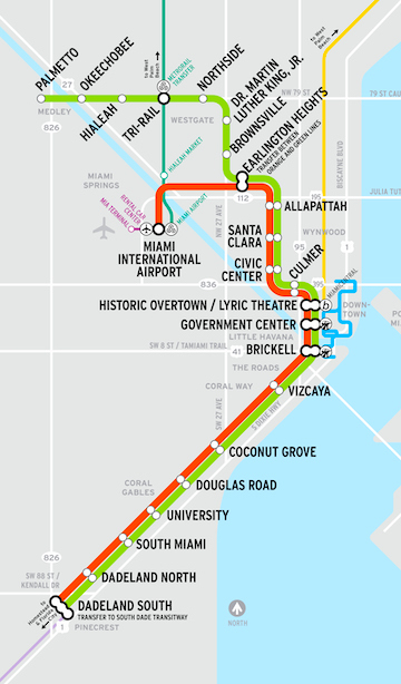
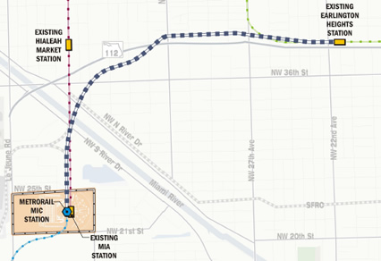
Miami

MetroRail Airport Rail Link

http://www.miamidade.gov/transit/improvement-airportlink.asp#4

Description: The Airport Rail link will be an elevated line that connects Miami's existing Earlington Heights Station on the Green Line to Miami International Airport. The Airport Rail link is the first part of the Orange Line which will eventually link Miami with western suburb Sweetwater and northern suburb Carol City.

Length: 2.4 miles (4 km)

Stations: 1

Opens: July 28, 2012

Maps and Renderings:


New York

Second Avenue Subway

http://www.mta.info/capconstr/sas/

Description: The long-planned Second Avenue Subway is under construction and will provide service along the east side of Manhattan Island. The need for a Second Avenue Subway to relieve the immense pressure on the rest of New York's subway system - the Lexington Avenue line in particular, was identified as early as the 1920s but has hit a number of stumbling blocks up to now.

Length: Phase 1: 2 miles (3.2 km), Full buildout: 8.5 miles (13.7 km)

Stations: 16

Opens: Phase 1: 2016

Maps and Renderings:


Number 7 Subway Extension

http://www.mta.info/capconstr/7ext/

Description: The number 7 subway line will be extended west along 42nd Street and south along 11th Avenue to W 34th Street. This extension is part of the grander Hudson Yards Redevelopment.

Length: 1.5 miles (2.4 km)

Stations: 1 now, 1 optional at a later date

Opens: June 2014

Maps and Renderings:


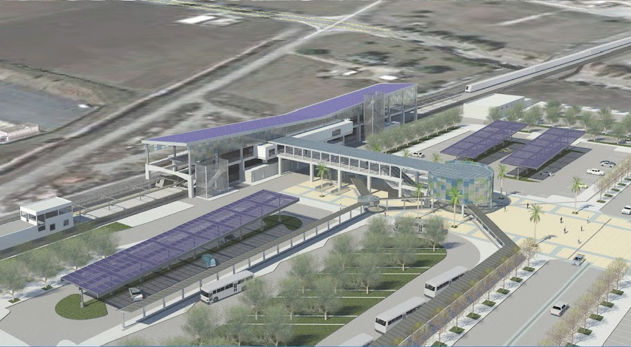
San Francisco

BART Warm Springs/Fremont Extension

http://www.bart.gov/about/projects/wsx/

Description: This extension goes from the existing southern BART terminus station Fremont along a primarily at-grade alignment into the Fremont municipality.

Length: 5.4 miles (8.6 km)

Stations: 2

Opens: 2015

Maps and Renderings:


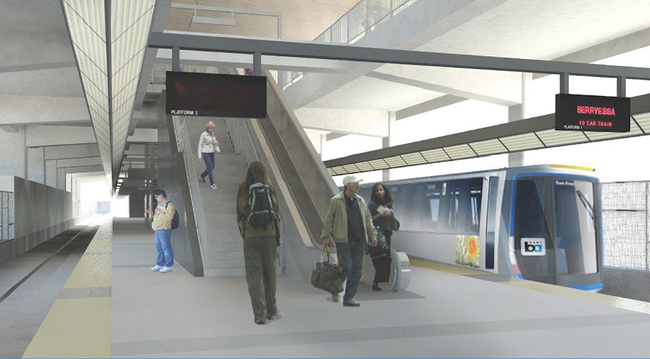
BART Berryessa Extension

http://www.bart.gov/about/projects/wsx/

Description: The Berryessa Extension will bring the BART system south from Warm Springs/Fremont Station south into San Jose. It is part of the longer-term project of extending BART into the Silicon Valley. Construction will be concurrent with the Warm Springs/Fremont extension. The line will run predominantly at-grade.

Length: 10 miles (16 km)

Opens: 2018

Stations: 2

Maps and Renderings:


Washington DC

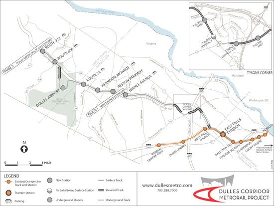
Dulles Corridor Metrorail Project (Silver Line)

http://www.dullesmetro.com/

Description: This extension project will link the existing Orange Line at East Falls Church station westward to Tyson's Corner, Dulles International Airport and beyond. The line will run in a predominantly elevated alignment.

Length: 12 miles (19 km)

Stations: 11 now, 1 optional infill station may be be added later

Opens: Phase 1 to Wiehle/Reston East Station in 2013. Phase 2 to Dulles International Airport and further to Route 772 in 2016.

Maps and Renderings:


Next Part: Light Rail Projects

     
     
  #5277  
Old Posted Aug 6, 2012, 5:56 AM
DarkKeyo DarkKeyo is offline
Transit/Cartography Geek
 
Join Date: May 2008
Location: Burnaby
Posts: 332
Quote:
Originally Posted by UofC.engineer View Post
In my opinion having the SW BRT going across the dam and using 14th street would be faster and attract a higher ridership than going to MRU and travelling via Crowchild trail.

On that note, I don't think the SW BRT should stop at MRU. A stop at MRU would take an extra 5-10 min longer to reach downtown and detract SW commuters from taking the BRT and instead use the LRT. The planned BRT station at Heritage or Rockyview would be a sufficient transfer point for MRU students.
I would think that MRU would be a higher trip generator than the deep SW. I don't know if the demographics of the area along 14 St south of the reservoir include a lot of transit users, but I do know MRU does, if only because dozens of people, including anyone I know who attends, constantly tell me they need more transit.
     
     
  #5278  
Old Posted Aug 6, 2012, 6:31 AM
UofC.engineer's Avatar
UofC.engineer UofC.engineer is offline
Laura Palmer
 
Join Date: Nov 2010
Location: Twin Peaks, Calgary, AB
Posts: 1,033
Quote:
Originally Posted by DarkKeyo View Post
I would think that MRU would be a higher trip generator than the deep SW. .
Lol, I agree. I apologize if I wasn't clear, I meant to say the SW BRT would be more beneficial if it went from Deep South West over Glenmore dam then 14th street. I'm talking about the 14th street from about 40th ave to 17th ave then downtown.
     
     
  #5279  
Old Posted Aug 6, 2012, 11:04 AM
outoftheice outoftheice is offline
Registered User
 
Join Date: Jan 2009
Posts: 914
Quote:
Originally Posted by frinkprof View Post
This is the first part of a series I've been meaning to do for awhile. I will give a look at what other cities are doing. For now it will be a listing (much like the one on the first page) of extension projects in other cities. After awhile, I may get into more detailed profiles of select cities. Not sure how fast this will roll out, but probably only when I get some time to work on it.
Very interesting read... thanks for assembling this information. I don't know how difficult it would be to do, but is it possible for you to include how these various extension projects have been funded?? I find when it comes to conversations about building the SE LRT and the NC LRT, it becomes a lot easier to advocate for the projects when other people realize just what other cities have been able to accomplish as far as transit projects go. However the next question in those discussions is usually "well how can we pay for it?". It would be very interesting to see the various funding models other cities are using to fund their transit projects and discussing how they might be applied here in Calgary.
     
     
  #5280  
Old Posted Aug 6, 2012, 3:35 PM
5seconds 5seconds is offline
Closed account
 
Join Date: Mar 2011
Posts: 935
Calgary Transit are aware of the option of using the dam (whether they believe it's a legitimate option is anyones guess). I really like the idea because it totally avoids the causeway, and the infrastructure is largely already there (including a connection at the Glenmore/14th interchange.)

Trying to put a commuter line over the causeway just seems like a bad idea from the outset.

As for keeping MRU out of it: I think that if there was a way of also providing a more direct/express service to MRU from downtown, I would be all for removing MRU from the SW BRT. It seems to me that the riders from the Woodbine area are not likely to be going to MRU, so having the SWBRT bypass there altogether and run directly down 14th to Downtown seems like a good idea. Saying that, MRU does need better transit, so if that change ever happened, it would have to be supplemented with other service (I think).

I'm not sure how the Westbrook-MRU BRT option will be received. I don't know where MRU visitors tend to travel from, and if a direct-from-downtown would be better received than the BRT from Westbrook.
     
     
This discussion thread continues

Use the page links to the lower-right to go to the next page for additional posts
 
 
Closed Thread

Go Back   SkyscraperPage Forum > Regional Sections > Canada > Alberta & British Columbia > Calgary > Transportation & Infrastructure
Forum Jump


Forum Jump


All times are GMT. The time now is 5:08 AM.


Powered by vBulletin® Version 3.8.7
Copyright ©2000 - 2026, vBulletin Solutions, Inc.