West End Redevelopment

polishavenger

New member
I have long been thinking about how the city could rehabilitate the west end where the bus station and car dealerships are. With the west LRT in the works, i think the city has a great chance to make things happen. I have done up a quick and dirty conceptual diagram on microsoft paint. I will be following it up with some more detailed numbers and road layouts. I think this project would probably pay for itself with the land sales, and the added property tax would be a great cash flow. Just for a quick comparable, this area contains 12 - 15 times more land than the old bus barns by eau claire. This means you could put in roughly 9000 - 10000 units in this place.
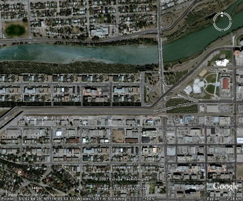
WestEndRedevelopmentandStreetRealig.jpg
 
Hey Aralaus, I think he forgot your stadium... Good job polish! You did this with paint!?!? For a second there I thought it was real, but I was thinking that the west end doesn't look anything close to this neat.
 
Great job. I would leave a slightly larger swath of green space along the river and eliminate the ramps off 14th Street.
 
Too bad a new stadium could not fit there as I think it would be nice for you guys to have the new McMahon there and give the Stamps their own home.
 
I think riverfront/adjacent property is too valuable and limited to use as a stadium space. I can picture this neighbourhood like a much larger version of what anthem/exchange/keynote and Arriva will create in their respective developments. I think a line of 4-8 storey midrises along the river with a retail promenade would be fantastic. I toyed with the idea of creating a linear park on the south side of the CPR tracks, and then running up the middle to connect to the river.

When I get my hands on a copy of photoshop, I will try to make this prettier.

As far as eliminating the 14th Street ramps, I thought about it, but I think they need to stay. They add a needed connection of that route into and out of the core.
 
Here was my idea from a while back. I'd like to see a bit more park space than what polishavenger is proposing. Except push bow trail south like he has.

westpark-1.jpg
 
Park space is important, but cant be the majority of the space. I estimated fewer condo units than what probably can be put in that space to account for more park area. If you use the Eau Claire project as a benchmark, the same area as that lot can fit about 12 times into the west end. That means around 12000 units. If you add more park space, that comes down to about 8000 units. Plus, I think a park that disects the area north south and connects the river bank to a new linear park along the south of the CPR tracks would be better because you use land that is less desirable for living and improve it, rather than taking away very attractive residential space.

The whole thing has to have enough value from re-sale of land and future property taxes to justify the several hundred million required to make it happen. I will put together a more detailed plan, and estimate some actual density figures and a cost estimate.
 
^I agree about having too much park space. However, in reality a project of this nature is unlikely to go through without huge amounts of parkland. That seems to be par for the course now. I do like the idea of linear parks that go through the neighbourhood. That would allow for connectivity between areas and allow for parks that area actually used by residents.
 
so where is the c-train station in there? if you want to insert 12,000 units in such a small area, there better be a train station right in the midst of it all (and not something where you have to walk half a mile over to. We need to start creating station right in the mids of the action, not adjacent to it.
 
There is a C-train station planned in the west leg alignment to go right in the centre of the image. When I do a better rendition of this image, I will put in where the station would go best. I think it should be designed to be a centre of activity for the neighbourhood, with great connections over the roadways to the south and north portions of the neighbourhoods. I would also think that the linear park/a retail boulevard should head north from the station.
 
Here's a super quick paint job I did for what I'd like to see on the site. Get rid of the 14th st. interchange as much as possible to allow access from the East. Extend 17th st. north into the site, and have it as a wide boulevard with central park. Retail podiums can line this boulevard and extend a few blocks along the riverfront road as well (shown in pink). Height is maximized to the south of the site, while the river fronting buildings should be no more than 5 or 6 stories. There are 3 major linear parks, one at the south, one fronting the river and the one in the centre of the boulevard. Smaller parks link these mid-block for connectivity. And the LRT station is where 17th st. enters the site. Not too sure how this would pan out, there'd have to be some interesting grade seperation to make it work, perhaps have bow trail run below grade in a trench?

westend%20copy.jpg
 
I think making those pseudo-freeways into regular arterial streets has to be part of any redevelopment plan. Get rid of that interchange!
 
I think making those pseudo-freeways into regular arterial streets has to be part of any redevelopment plan. Get rid of that interchange!

Agreed. In regard to the open space. I do think at least something big enough to be able to toss a frisbee or play a game of soccer is necessary. Linear paths are nice, but don't leave very many options for active recreation. I think that is important too.


Back
Top