New subdivision developments


Havencourt (not to be confused with Havencrest) rezoning app
http://app01.ottawa.ca/postingplans/appDetails.jsf?lang=en&appId=__81FWCV

http://tartanhomes.com/en/communities/havencourt

Phase_4710_Topo.jpg
 
Potential for a new eco-neighborhood in the area inside Saint-Louis, Paiement and Maloney currently a golf course. It would be designed by a Vancouver developer who've just made an offer to Produits Resolu Forestiers to buy the land whivch includes the golf course (ex-Bowater, ex-CIP). The developper is planning mixed commercial and residential. Obviously Maloney Blvd, will likely be commercial.

Maybe it would grate to have a crossing that would connect to the future Gouin Station of the Rapibus.

(article is in French though).

http://www.cyberpresse.ca/le-droit/...erpresse_B4_en-manchette_1646213_section_POS4
 
Potential for a new eco-neighborhood in the area inside Saint-Louis, Paiement and Maloney currently a golf course. It would be designed by a Vancouver developer who've just made an offer to Produits Resolu Forestiers to buy the land whivch includes the golf course (ex-Bowater, ex-CIP). The developper is planning mixed commercial and residential. Obviously Maloney Blvd, will likely be commercial.

Maybe it would grate to have a crossing that would connect to the future Gouin Station of the Rapibus.

(article is in French though).

http://www.cyberpresse.ca/le-droit/...erpresse_B4_en-manchette_1646213_section_POS4

My fear is that the écoquartier would just be the French version of the "garden city" that is Kanata's Beaverbrook - a nice way to say the lots will be large and require fewer trees to be cut down, but not actually being all that environmentally friendly.
 
Last edited:
If it's low density and car-centric, then it ain't eco-anything!

That said, Quebec hydro is green, and cheap!
 
Highbury Park Drive is going to quickly become a busy road once it's linked to Greenbank because it will essentially be a shortcut to get to Longfields instead of going via Berrigan. Also, I'm wondering if OC Transpo would consider building a station at Highbury Park once the development is complete. Or would the density not be high enough to spend money on a new station when Longfields and Strandherd are semi-close enough?
 
If it's low density and car-centric, then it ain't eco-anything!

That said, Quebec hydro is green, and cheap!

It's probably one of those few spots near/along the Rapibus corridor that can present an occasion for higher density - hopefully they won't miss out on that one. There isn't a lot of other occasions.

Meanwhile sounds there will be a bit of density along the Gatineau River near the Alonzo Wright Bridge. Brigil is planning up to 1000 units to be added to its existant Vieux-Port subdivision. Brigil is also hoping to built a hotel as well as a private marina. There could be 2-6 storey condominium buildings as well. The projet would start next year according to LE Droit (Tuesday's paper)

http://www.cyberpresse.ca/le-droit/actualites/ville-de-gatineau/?p=2195-3
 

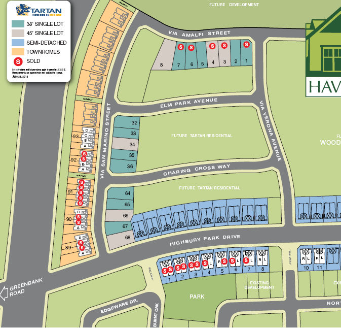
Love the townhouse soundwall against the Transitway. I also love how none of the promotional literature makes mention of the fact that that is a transitway on the left - it's not even in the "Green Features" brochure. The map itself isn't exactly accurate, either, since Highbury will go over the Transitway on an already-built overpass.

Highbury Park Drive is going to quickly become a busy road once it's linked to Greenbank because it will essentially be a shortcut to get to Longfields instead of going via Berrigan. Also, I'm wondering if OC Transpo would consider building a station at Highbury Park once the development is complete. Or would the density not be high enough to spend money on a new station when Longfields and Strandherd are semi-close enough?

Frankly, it wouldn't surprise me if one day Berrigan gets cut-off at the Transitway to general use since Highbury with its overpass is nearby. It's only ~1.5 km between Longfields and Strandherd Stations so there will not be a station at Highbury.
 
Love the townhouse soundwall against the Transitway. I also love how none of the promotional literature makes mention of the fact that that is a transitway on the left - it's not even in the "Green Features" brochure. The map itself isn't exactly accurate, either, since Highbury will go over the Transitway on an already-built overpass.


Frankly, it wouldn't surprise me if one day Berrigan gets cut-off at the Transitway to general use since Highbury with its overpass is nearby. It's only ~1.5 km between Longfields and Strandherd Stations so there will not be a station at Highbury.

They should also get rid of the Park and Ride at Strandherd and develop that area as well, especially once the Transitway corridor is extended south. A MASSIVE Park and Ride should be built at the Bankfield/416 interchange area to grab 416 traffic.
 
Dado: I don't think Berrigan should/will be cut off simply because there is enough local traffic in that area to warrant two connections from Greenbank into that community. Also, the signalized intersection of the Transitway and Berrigan allows for pedestrians to cross the street to access the bus station and shopping plazas.

Eternallyme: As much as I don't like parking lots, by eliminating the Strandherd Park n' Ride you're going to congest Fallowfield again because nobody is going to drive south to park their car, and then commute back to the north. Also, how many people who commute from portions south of Ottawa who take the 416 are actually willing to Park n' Ride instead of just continuing their drive into the city? I would think most people would simply continue there drive because parking and taking transit is going to add considerable time to their already longer commute. Perhaps a larger Carpooling lot could be built. Every time I drive by the current carpooling lot at Bankfield during the day it seemed to be fairly full.
 
This may have been asked before, but...

What is the plan (if there is any) for the massive undeveloped tract of land (roughly 275 acres) between Riverside and McCarthy, south of the railway and hydro corridors? As far as I know, it is the largest undeveloped tract of land inside the Greenbelt that is not protected. There is a smaller tract east of McCarthy as well.

It seems to be a difficult plot to plan, as it is not transit-conducive, nor does it felt in well with any of the community street networks.
 
This may have been asked before, but...

What is the plan (if there is any) for the massive undeveloped tract of land (roughly 275 acres) between Riverside and McCarthy, south of the railway and hydro corridors? As far as I know, it is the largest undeveloped tract of land inside the Greenbelt that is not protected. There is a smaller tract east of McCarthy as well.

It seems to be a difficult plot to plan, as it is not transit-conducive, nor does it felt in well with any of the community street networks.

owned by the NCC... use TBD.


Back
Top