HomeDiagramsDatabaseMapsForum About
     

Go Back   SkyscraperPage Forum > Regional Sections > United States > Southeast > Atlanta


Reply

 
Thread Tools Display Modes
     
     
  #1361  
Old Posted Oct 25, 2022, 12:47 PM
shivtim's Avatar
shivtim shivtim is offline
Registered User
 
Join Date: Aug 2008
Location: Midtown Atlanta
Posts: 2,361
I haven't seen what the plans are either, but I think the best place for a connection is at Jefferson Street. It would connect directly into where the new part of the Beltline on Marietta Street hits the westside connector. The terrain is elevated here to the east, making it easier to build a bridge over the railroad tracks without complicated ramps. Then it's about 1300 feet to the Proctor Creek Trail, utilizing GA Power right of way (which we know they can do because it's what was done with a big portion of the existing Proctor Creek Trail).

Reply With Quote
     
     
  #1362  
Old Posted Oct 25, 2022, 1:26 PM
Street Advocate Street Advocate is offline
Registered User
 
Join Date: Oct 2015
Posts: 3,675
Julien just general FYI you keep saying Northside, which idk if you mean an orientation or the street, but Northside Drive is nowhere nearby. I shared the connection for how it will cross from the existing trail across DLH southbound to the BeltLine’s segment 4.

I saw some older plans that included a connection point to Westside park, also nowhere near Northside, at the access point Shivtim indicated. People have crossed in that area on bike rides already.
Reply With Quote
     
     
  #1363  
Old Posted Oct 25, 2022, 3:29 PM
Julien Julien is online now
Registered User
 
Join Date: Apr 2021
Location: ATL/Atlantic Station
Posts: 761
Quote:
Originally Posted by Street Advocate View Post
Julien just general FYI you keep saying Northside, which idk if you mean an orientation or the street, but Northside Drive is nowhere nearby. I shared the connection for how it will cross from the existing trail across DLH southbound to the BeltLine’s segment 4.

I saw some older plans that included a connection point to Westside park, also nowhere near Northside, at the access point Shivtim indicated. People have crossed in that area on bike rides already.
Sorry, DOUBLE brain fart this morning. I was saying Northside [Drive] but meaning to (also wrongly) say North Ave BUT is actually Hollowell Pkwy. Should have looked on the map (and I did since I posted Apple Map pics) or just said US78. Oddly US78 includes all 3.

Also I can't see how anyone could possibly pass there since you have to climb 2 fences and then cross the train tracks. There used to be some type of road that went through there and may be was what the bridge was for but it is ALL blocked off.


Reply With Quote
     
     
  #1364  
Old Posted Oct 25, 2022, 5:33 PM
Julien Julien is online now
Registered User
 
Join Date: Apr 2021
Location: ATL/Atlantic Station
Posts: 761
Also at the Red Arrow you can cross the tracks (no fence) from the Beltline. However it appears you are on GA Power property and there is no connection to Westside Park. GA Power blocks and at best it is dirt or crush and run (no pavement) and very uneven ground. Does anyone know what is GA Power property and what is Park property. GA Power does have a right of way through the park for high transmission lines going west towards my blue arrow. I took the pic at the Blue Arrow.

Seems this would also be an easy direct access from the Beltline but would GA Power allow it.


From Blue Arrow


Looking across the Beltline and towards the Park, Red Arrow.
Reply With Quote
     
     
  #1365  
Old Posted Oct 25, 2022, 9:19 PM
Julien Julien is online now
Registered User
 
Join Date: Apr 2021
Location: ATL/Atlantic Station
Posts: 761
Was scanning the Beltline info again and noticed this. When I came to this section a couple of weeks ago I thought it was odd to have little plaza and then the trail to weirdly divide only to come back together (waste of concrete). In the PDF brochure it says that the plaza is where Section 3, 4 and the West Connector meet up. So I guess the trail to the left (south) will have a connection in the middle running perpendicular to cross Hollowell Pkwy and the Connector heading downtown is behind me and ends at this point. So right will be north Beltline and left will be south Beltline (unless you just loop past the turn). This would also explain the solid yellow line dividing.

Reply With Quote
     
     
  #1366  
Old Posted Oct 26, 2022, 3:21 PM
trainiac's Avatar
trainiac trainiac is offline
Registered User
 
Join Date: Feb 2006
Location: Atlanta - Grove Park
Posts: 1,059
Quote:
Originally Posted by Julien View Post
Was scanning the Beltline info again and noticed this. When I came to this section a couple of weeks ago I thought it was odd to have little plaza and then the trail to weirdly divide only to come back together (waste of concrete). In the PDF brochure it says that the plaza is where Section 3, 4 and the West Connector meet up. So I guess the trail to the left (south) will have a connection in the middle running perpendicular to cross Hollowell Pkwy and the Connector heading downtown is behind me and ends at this point. So right will be north Beltline and left will be south Beltline (unless you just loop past the turn). This would also explain the solid yellow line dividing.
That's where the connector ended for a while. I just used it as a cul-de-sac to turn back around when I biked it. I absolutely love that sign: miles to downtown and Stone Mountain
__________________
Atlanta history blog
Reply With Quote
     
     
  #1367  
Old Posted Oct 28, 2022, 11:26 AM
Julien Julien is online now
Registered User
 
Join Date: Apr 2021
Location: ATL/Atlantic Station
Posts: 761
Some NOT so good news on the 1.3 mile Segment 4. Construction is going to take 2½ years. As stated in the Urbanize “For context, that’s almost exactly how long it took the Atlanta Braves’ $672-million Cobb County stadium to break ground and host its first game.” Unbelievable that an entire mini city with a professional stadium can be built in less time than it takes to build a “sidewalk”.

Guess we can expect an entrance from The Beltline into Westside Park before the end of the decade, maybe.

https://atlanta.urbanize.city/post/b...ur-development

Last edited by Julien; Oct 28, 2022 at 11:36 AM.
Reply With Quote
     
     
  #1368  
Old Posted Oct 28, 2022, 12:11 PM
montydawg montydawg is offline
Registered User
 
Join Date: May 2016
Location: NYC
Posts: 814
Quote:
Originally Posted by Julien View Post
Some NOT so good news on the 1.3 mile Segment 4. Construction is going to take 2½ years. As stated in the Urbanize “For context, that’s almost exactly how long it took the Atlanta Braves’ $672-million Cobb County stadium to break ground and host its first game.” Unbelievable that an entire mini city with a professional stadium can be built in less time than it takes to build a “sidewalk”.

Guess we can expect an entrance from The Beltline into Westside Park before the end of the decade, maybe.

https://atlanta.urbanize.city/post/b...ur-development

It is much cheaper to build things slowly with fewer employees than overstaff and work under tight deadlines. It is usually a more efficient use of equipment and employees going leaner (except when they have expensive rentals, like cranes, etc)
Reply With Quote
     
     
  #1369  
Old Posted Nov 10, 2022, 8:46 PM
trainiac's Avatar
trainiac trainiac is offline
Registered User
 
Join Date: Feb 2006
Location: Atlanta - Grove Park
Posts: 1,059
Quote:
Originally Posted by shivtim View Post
I haven't seen what the plans are either, but I think the best place for a connection is at Jefferson Street. It would connect directly into where the new part of the Beltline on Marietta Street hits the westside connector. The terrain is elevated here to the east, making it easier to build a bridge over the railroad tracks without complicated ramps. Then it's about 1300 feet to the Proctor Creek Trail, utilizing GA Power right of way (which we know they can do because it's what was done with a big portion of the existing Proctor Creek Trail).
Just got an updated PATH map in the mail. If those two green dashes are accurate, it looks like they're planning to use the GA Power ROW. Which would mean an at-grade rail crossing
__________________
Atlanta history blog
Reply With Quote
     
     
  #1370  
Old Posted Nov 16, 2022, 3:51 PM
GeorgiaPeanuts GeorgiaPeanuts is online now
Registered User
 
Join Date: Sep 2014
Posts: 1,537
https://beltlineorg.wpenginepowered....g_20221103.pdf

The 30% designs for Segment 5 of the northwest beltline show designs for connection with a silver comet connector trail. Is this a good sign that the silver comet connector is coming soonish? Being car free would love to be able to bike from intown all the way up to the silver comet trail and back without having to rent a vehicle.
Reply With Quote
     
     
  #1371  
Old Posted Nov 18, 2022, 4:03 PM
GPBRDL GPBRDL is offline
Registered User
 
Join Date: Aug 2020
Posts: 8
Quote:
Originally Posted by GeorgiaPeanuts View Post
https://beltlineorg.wpenginepowered....g_20221103.pdf

The 30% designs for Segment 5 of the northwest beltline show designs for connection with a silver comet connector trail. Is this a good sign that the silver comet connector is coming soonish? Being car free would love to be able to bike from intown all the way up to the silver comet trail and back without having to rent a vehicle.
Who knows... I too have been eagerly awaiting this connection. I think it was the spring 2021 PATH newsletter that indicated the silver comet would connect to the whetstone creek trail by end of 2022 and funding was already in place. The latest PATH map shows at least a portion as being completed, but I only saw an overgrown rail bed when I went by a few weeks ago...
Reply With Quote
     
     
  #1372  
Old Posted Jun 6, 2023, 11:49 PM
smArTaLlone smArTaLlone is offline
Registered User
 
Join Date: Feb 2005
Posts: 8,589
Atlanta bans self-storage buildings near BeltLine

https://www.bizjournals.com/atlanta/...l?cx_testId=40
Quote:
New warehouses, self-storage buildings and distribution centers will no longer be welcome within 500 feet of the Atlanta BeltLine.

Atlanta City Council recently approved an ordinance to ban new buildings from being erected for those uses near the multi-use trail. The zoning change corrects a proofreading mistake made during a previous update to the city's code, according to the ordinance. The error allowed Atlanta Botanical Garden to move forward with a controversial plan for a Public Storage facility on Monroe Drive near an entrance to the Eastside Trail.

The ban is part of a push by local leaders and community members to reshape the built environment with pedestrians and cyclists in mind. The city is considering several new regulations related to the BeltLine, such as banning new drive-thrus and gas stations within a half-mile of the multi-use trail. Another proposed change would remove parking minimums near the corridor.
Reply With Quote
     
     
  #1373  
Old Posted Jun 7, 2023, 1:34 PM
shivtim's Avatar
shivtim shivtim is offline
Registered User
 
Join Date: Aug 2008
Location: Midtown Atlanta
Posts: 2,361
^ The proposed storage facility on Monroe hasn't been permitted yet, correct? So it is essentially blocked? Or it gets granfathered in somehow? I wonder if this means the botanical garden will pause their expansion plans, or if they'll proceed and the storage facility will relocate elsewhere.
Reply With Quote
     
     
  #1374  
Old Posted Jun 7, 2023, 2:13 PM
smArTaLlone smArTaLlone is offline
Registered User
 
Join Date: Feb 2005
Posts: 8,589
Quote:
Originally Posted by shivtim View Post
^ The proposed storage facility on Monroe hasn't been permitted yet, correct? So it is essentially blocked? Or it gets granfathered in somehow? I wonder if this means the botanical garden will pause their expansion plans, or if they'll proceed and the storage facility will relocate elsewhere.
They mentioned that since the plans for the Botanical Garden storage facility have already been filed, it would not be affected by the new ban.
Reply With Quote
     
     
  #1375  
Old Posted Jun 7, 2023, 2:58 PM
MarketsWork MarketsWork is offline
Registered User
 
Join Date: Oct 2006
Posts: 785
Quote:
Originally Posted by smArTaLlone View Post
They mentioned that since the plans for the Botanical Garden storage facility have already been filed, it would not be affected by the new ban.
The Constitution prohibits both Congress and the States from passing any "ex post facto" laws, its intent being to protect and preserve lawful actions, commitments and relationships that existed prior to the passage of more restrictive laws.
Reply With Quote
     
     
  #1376  
Old Posted Jun 7, 2023, 5:55 PM
Street Advocate Street Advocate is offline
Registered User
 
Join Date: Oct 2015
Posts: 3,675
Quote:
Originally Posted by smArTaLlone View Post
They mentioned that since the plans for the Botanical Garden storage facility have already been filed, it would not be affected by the new ban.
If this is true, then the 500’ doesn’t go far enough. Mitigating storage facilities within ~1 block is insufficient, it needs to go further.
Reply With Quote
     
     
  #1377  
Old Posted Jun 28, 2023, 2:59 PM
smArTaLlone smArTaLlone is offline
Registered User
 
Join Date: Feb 2005
Posts: 8,589
BeltLine secures $25 million for Armour Yards, Lindbergh trail

https://www.bizjournals.com/atlanta/...Pos=0#cxrecs_s

Quote:
A few years from now, Atlanta residents will be able to reach Armour Yards, Lindbergh and other parts of Buckhead via the BeltLine.

That's because Atlanta BeltLine Inc. secured $25 million to offset a funding gap for constructing 2.2 miles of trails through northeast Atlanta, the organization said Tuesday. The project involves adding two routes that branch off from the mainline trail.

A westbound route will connect to MARTA's Lindbergh Center rail station, while an eastbound route will connect to PATH400, Peachtree Creek Greenway and Confluence Trail.

ABI, the nonprofit managing the build-out of the BeltLine, expects to start construction on the $70.7 million project in 2025 with a two-year construction period. The latest source of funding will come from a Rebuilding American Infrastructure with Sustainability and Equity (RAISE) grant awarded by U.S. Department of Transportation. ABI said this is the largest federal grant in the BeltLine's history.
Reply With Quote
     
     
  #1378  
Old Posted Jun 28, 2023, 3:37 PM
testarossa50 testarossa50 is offline
Registered User
 
Join Date: Mar 2008
Posts: 764
It will be really interesting to see how the project zig-zags across Marta 3 times, NS 2 times, and CSX 1 time before getting to Lindbergh station. Glad it's not my project to deal with.
Reply With Quote
     
     
  #1379  
Old Posted Jun 29, 2023, 12:33 PM
Street Advocate Street Advocate is offline
Registered User
 
Join Date: Oct 2015
Posts: 3,675
Quote:
Originally Posted by testarossa50 View Post
It will be really interesting to see how the project zig-zags across Marta 3 times, NS 2 times, and CSX 1 time before getting to Lindbergh station. Glad it's not my project to deal with.
The northern most sections just follows the existing road & sidewalk on Garson Dr.
Reply With Quote
     
     
  #1380  
Old Posted Aug 21, 2023, 5:16 PM
Julien Julien is online now
Registered User
 
Join Date: Apr 2021
Location: ATL/Atlantic Station
Posts: 761
Here is Pediment park Beltline pics starting North to South.


Pediment Ave looking north.


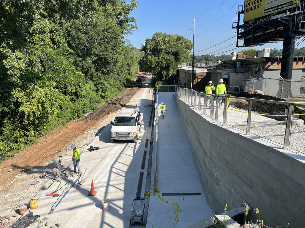
Westminster Dr. looking north with Pediment Ave in background


180º Westminster Dr. looking south. This is the Beltline right of way that won't be used now. Using existing Pediment Park trail to right of pic about 30'.


Existing Pediment Park trail looking south with "old" Beltline right of way to left across a creek. Looks like the plan is to upgrade the existing Pediment Park trail.


Point where Beltline turns/exits and moves back on the right of way at Park Dr (bridge/above). This is looking west towards the Pediment Park trail and Beltline would turn right/north on the Pediment Park trail.


180º looking east and Beltline right of way top of steps. Will turn right/south.


Pediment Park parking/Beltline trail looking north with the infamous Monroe Dr crossing behind me.
Reply With Quote
     
     
This discussion thread continues

Use the page links to the lower-right to go to the next page for additional posts
 
 
Reply

Go Back   SkyscraperPage Forum > Regional Sections > United States > Southeast > Atlanta
Forum Jump


Forum Jump


All times are GMT. The time now is 7:22 PM.

     
SkyscraperPage.com - Archive - Privacy Statement - Top

Powered by vBulletin® Version 3.8.7
Copyright ©2000 - 2024, vBulletin Solutions, Inc.