HomeDiagramsDatabaseMapsForum About
     

Go Back   SkyscraperPage Forum > Regional Sections > Canada > Ontario > Ottawa-Gatineau > Ottawa Photos


Reply

 
Thread Tools Display Modes
     
     
  #1  
Old Posted Aug 14, 2018, 3:38 AM
AuxTown's Avatar
AuxTown AuxTown is offline
Registered User
 
Join Date: Apr 2006
Location: Ottawa, Canada
Posts: 4,109
Ottawa Maps

Not really photos but I thought this would be a good place for everything "Map" about Ottawa. I'll start with these very cool wooden maps I saw posted on Reddit this evening. A home decor must for all the SSP forumers in your life :-)

https://www.etsy.com/ca/shop/WoodenE..._shop_redirect

This guy does some cool stuff:


I think I like the zoomed out Ottawa map or the coasters the best.
Reply With Quote
     
     
  #2  
Old Posted Aug 15, 2018, 6:46 PM
J.OT13's Avatar
J.OT13 J.OT13 is offline
Moderator
 
Join Date: Mar 2012
Location: Ottawa
Posts: 24,021
Nice! My girlfriend gave me these coasters last Christmas:


https://makerhouse.com/products/ottawa-map-coasters

Is there a way to resize images on site

Last edited by J.OT13; Aug 15, 2018 at 7:01 PM.
Reply With Quote
     
     
  #3  
Old Posted Aug 15, 2018, 7:13 PM
Kitchissippi's Avatar
Kitchissippi Kitchissippi is online now
Busy Beaver
 
Join Date: Nov 2005
Location: Ottawa
Posts: 4,364
They sell these trivets at ikindalikeithere.com

Reply With Quote
     
     
  #4  
Old Posted Aug 16, 2018, 3:03 PM
Uhuniau Uhuniau is offline
Registered User
 
Join Date: Jan 2010
Posts: 8,034
You may regret starting this thread because lordy, there are maps.
__________________
___
Enjoy my taxes, Orleans (and Kanata?).
Reply With Quote
     
     
  #5  
Old Posted Dec 13, 2018, 6:05 PM
daud's Avatar
daud daud is offline
Registered User
 
Join Date: Jun 2012
Location: Ottawa
Posts: 739
moved to photos...
Reply With Quote
     
     
  #6  
Old Posted Feb 10, 2019, 2:15 PM
J.OT13's Avatar
J.OT13 J.OT13 is offline
Moderator
 
Join Date: Mar 2012
Location: Ottawa
Posts: 24,021
Quote:
7 maps that tell the story of Ottawa

Trevor Pritchard · CBC News · Posted: Jan 07, 2019 4:00 AM ET | Last Updated: January 7

For city archivist Paul Henry, maps are just one more way to tell Ottawa's story.

"You can see the resilience of community over time. You can see the evolution of a community over time," says Henry, who recently gave CBC Ottawa access to its vast collection of city maps.

"You get a real sense of history in the place names and the street names."

We've taken some of those old maps, added a few from other sources, and brought them all together in this attempt to forge a cartographic chronicle of the city's past.

Humble beginnings (1863)


One of the oldest in the city's collection, this 1863 map of the former Carleton County nevertheless "describes in essence what is now Ottawa," Henry said.

But not all of it, of course.

Four years before Confederation, Ottawa was essentially limited to Lowertown, the ByWard Market and the western and northern parts of downtown.

Its population was less than 15,000, and it was dwarfed geographically by the surrounding county and its townships.

Some of those communities were roughly the same size; an "apocryphal" story, Henry said, suggested the modern-day rural Ottawa neighbourhood of Richmond was even in the running to be Canada's capital.

The Ottawa of 1863 may be tiny compared to today, but not totally unrecognizable. As the inset in the bottom left corner shows, the city's downtown street grid from 156 years ago looks much like it does today.


A growing capital (1887)


By 1887, Ottawa had been the nation's seat of government for two decades — and this map, another of the city's oldest, shows the accompanying growth.

Ottawa's sudden turn from lumber town to national capital led to an "influx" of civil servants, said Henry, and the population doubled to nearly 34,000.

Lansdowne Park pops up on city maps for the first time. So does the Central Experimental Farm, Dow's Lake and Rideau Hall.

Some of the street names and neighbourhoods may be unfamiliar to an average 21st-century Ottawan, but they show how lumber barons like William Stewart and their families held sway in the capital's early days.

The map also shows how tightly connected the city's modern transportation network is to old rail. The path of the Canada Atlantic Railway should look familiar: it would eventually be acquired by the city and turned into the Queensway. Another rail line, meanwhile, runs along what's now the Vanier Parkway.

Finally, the 1887 map is a reminder of what Henry called the city's "disappeared" communities, like the small settlement on land later used for the Supreme Court of Canada. There's also a certain working class community on the map just west of downtown whose dismantling in the mid-20th century reverberates to this day.

Streetcar city (1909)


Long before light rail became a topic of great debate and consternation, Ottawa was connected by a bustling streetcar network.

This 1909 map shows the peak of that network, which was operated by the privately-run Ottawa Electric Railway Company. And its lines, Henry said, offer a glimpse at life in the early 20th century.

The red line heading off the map's west end would have ferried riders to the recently-opened Britannia Park — evidence of its popularity as a weekend destination for rest and relaxation.

The line running straight into the heart of the Central Experimental Farm shows its importance as a working farm, while the line running across to downtown Hull testifies to the longstanding connection between the two communities.

Streetcar service lasted until 1959. The lines were eventually pulled out and, along with most of the cars, sold for scrap.

Gréber comes to town (1950)


For Alain Miguelez, the city's history can be divided into two eras: before and after the Gréber Plan.

Commissioned after the Second World War, the ideas put forward by French architect Jacques Gréber were designed to "increase the prestige of Ottawa as the nation's capital," said Miguelez, the city's manager of planning policy and the author of Transforming Ottawa, a book about the plan.

"Ottawa got an advance taste of what was to come in all other North American cities," said Miguelez.

"Everything sort of became bigger — largely driven by a wish to separate land uses from one another, and also for the sake of making automobile traffic flow faster and more freely."

The Greenbelt, represented on the map with green diagonal lines, came out of the plan. So did the car-first parkways along the Ottawa River, a big departure from the streetcar era.

The plan created worker-only spaces for federal government workers — like the Tunney's Pasture government campus and the National Research Council complex on Montreal Road, both of which appear in crosshatches on the map.

Not everything in the plan materialized, of course. But to this day, Miguelez said, planners are still grappling with how the Gréber Plan changed Ottawa.

The great amalgamation (2001)


Ottawa's population hit 200,000 by the mid-20th century, but it didn't stop growing.

First came the annexations of parts of the former Nepean and Gloucester in 1950, bringing neighbourhoods like Westboro into the city's fold.

Then, in 1999, the former Mike Harris government forced amalgamation upon a number of the province's municipalities — including Ottawa.

As this highway map from 2001 shows, the decision meant residents of former cities including Kanata, Vanier and Cumberland suddenly found themselves citizens of Ottawa instead.

Amalgamation certainly wasn't universally loved: rural communities felt their concerns would go unheard, while city dwellers didn't enjoy having country folks weighing in on urban matters. Eight years after it all went down, former councillor and mayoral candidate Clive Doucet called for the city to be split back up.

Obviously, that didn't happen. But amalgamation remains a formative moment in Ottawa's modern history. In fact, as recently as last year, local MPP Lisa MacLeod cited it as a reason that Ottawa, unlike Toronto, wouldn't see the size of its council contracted.

Historic claims (2016)


Ever attended a concert or a poetry reading in Ottawa where the master of ceremonies notes it's taking place on unceded Algonquin territory?

This map helps explain why.

Algonquin people have laid claim to their historic hunting and fishing territory around Ottawa for more than 250 years, on the grounds that no treaty ever extinguished their rights to the land.

In 2016, the Algonquins of Ontario struck a modern treaty with the provincial and federal governments — and this snapshot of the Ottawa area appears the agreement-in-principle forged through those negotiations.

The deal encompasses roughly 36,000 square kilometres, including a vast swath of the Ottawa Valley. The blown-up boxes in the above map show federal lands in Ottawa that are "for the most part vacant," said Robert Potts, senior negotiator for the Algonquins of Ontario.

It also shows how European settlers imposed their own boundaries upon the people who traditionally called the region home, Potts said.

"Our job, our task, is to try and reintroduce the Algonquin way of thinking ... that Aboriginal presence that has always been there," Potts said.

The future of mapping (2017)


If maps can truly tell the story of Ottawa, technological changes are increasingly allowing its citizens to become the storytellers.

"The mapmaker used to be the person who said 'This is what you get to see,'" said professor Fraser Taylor, director of the Geomatics and Cartographic Research Centre at Carleton University.

"That's changing, and changing dramatically. Mapping is becoming more democratized."

Technologies such as smartphones and access to a "whole range of qualitative and quantitative information" are allowing people to take mapping into their own hands, Taylor said.

This screenshot of a map from Bike Ottawa, which uses crowd-sourced data to give cyclists an evolving look at plowed winter bike routes, is a "small example" of that trend, he said.

Winter cycling in Ottawa today? There's a map for that
"In the past, because the map was a concrete piece of paper, you got one answer to your question," said Taylor.

"Instead of just presenting one perspective, we can [now] present a variety of different perspectives. So people can see there's no right or wrong answer quite often — but complex sets of perceptions. And each of those perceptions has validity in its own right."

Maps courtesy the City of Ottawa Archives, Queen's University, Ontario's Ministry of Transportation, the Algonquins of Ontario and Bike Ottawa.
https://www.cbc.ca/news/canada/ottaw...ives-1.4946627
Reply With Quote
     
     
  #7  
Old Posted Feb 10, 2019, 5:52 PM
CityTech CityTech is offline
Registered User
 
Join Date: May 2016
Location: Ottawa
Posts: 2,807
I was doing some local history research and trying to find out more about the history of Ottawa's political borders and got the whole story . When the city first became a municipality in 1850, it was carved out of the Township of Nepean, with it's border at the Rideau River to the east, a line corresponding to what is now Gladstone Avenue & Mann Avenue to the south, and Booth Street to the west (except north of Albert, where the city extended a little further to the west to include all of Lebreton Flats). So basically, just present-day Lowertown, the northern two-thirds of Sandy Hill and Centretown, Lebreton, and Chinatown. These were unchanged for nearly 40 years and were Ottawa's borders at the time of Confederation.

Ottawa's borders were expanded in 4 waves. One in 1887-1889, another in 1907-1910, another in 1950, and finally in 2001.

The first of these waves, in 1887-1889, brought New Edinburgh, the Glebe, and Little Italy into city limits. At this point, the northeastern border of the City of Ottawa reached its final pre-2001 form. The southern border became the Rideau Canal and the western border became the railway line that is now Line 2.

Around this time period, a bunch of villages sprouted up just past the city's borders. Old Ottawa East (then just called Ottawa East), Hintonburg, Mechanicsville, and Westboro were founded in the Township of Nepean, while Janeville, Clarkstown, Clandeboye, and Rockcliffe Park were founded in the Township of Gloucester just east of Ottawa's border. Of these, Ottawa East and Hintonburg became independent municipalities while the remainder remained within Nepean and Gloucester.

So the situation in the 1890s and into the first years of the 20th century was one of the City of Ottawa immediately bordered by several village suburbs, the largest of which were independent municipalities.

A major amalgamation (the second wave of expansion of the city limits) occurred in 1907. The municipalities of Ottawa East and Hintonburg were annexed to the City of Ottawa; at the same time, more bits of Nepean Township were annexed as well, covering Mechanicsville, what is now Old Ottawa South and the Civic Hospital area. A small triangle around what is now Westgate was added a bit later, in 1909. In the east however, none of the villages were added to the city at this time; the three villages of Janeville, Clarkstown, Clandeboye were merged to form the independent municipality of Eastview (renamed Vanier in 1966) while Rockcliffe Park remianed entirely separate, eventually separating from Gloucester to form its own municipality in 1926.

This map below (drawn by me) thus shows Ottawa's municipal borders as they were during both world wars.


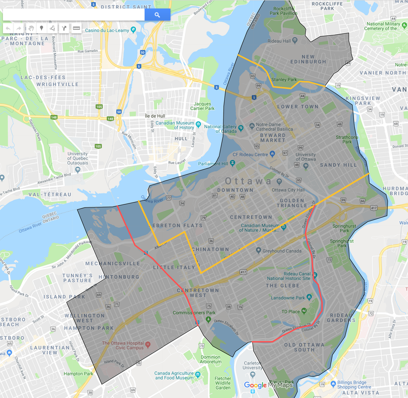
This is the City of Ottawa as its border existed from 1909 to 1948. In orange, I outlined the city's original 1850 borders, and in red, marked the limits of the 1889 annexation. The 1909-1948 City limits roughly incorporated all of what could be called the "urban" part of the city, minus Westboro and Vanier (then called Eastview) which existed as developed communities but were independent. It's interesting to note that what is now Tunney's Pasture and Carleton University were located just outside the city's limits.

It's also interesting that the western limit of the Village of Hintonburg that the city annexed in 1907 was at Western Avenue (which is probably how that street got its name--it was the city's western border!); it did not extend to Island Park, which is what people typically think of as the Hintonburg-Westboro border. This actually explains what I call "the great gap"--the sort of dead area along Richmond from about the Superstore to about Western Avenue that isn't really a part of either Westboro's or Hintonburg's urban form--Hintonburg didn't actually extend past Western Ave to directly meet Westboro.

By the time World War II happened the city had filled up all the land inside the borders and needed expansion territory. With the rapid population growth and the beginning of the baby boom and the home ownership boom, new land was needed. In 1948, this triggered a major review of municipal governance in the area. A small area consisting of the northern half of what is now Carlington (roughly north of Shillington Avenue from Merivale to fisher) was immediately annexed to Ottawa while this review was underway. The first proposal, published in May 1948, would have had Ottawa annex all of Gloucester, Nepean, Vanier (then Eastview), and Rockcliffe Park; this would have brought into the city all of what is now the urban area minus Kanata-Stittsville and eastern Orleans. Here's an online archived copy of the Citizen from May 17th, 1948 in which the proposal was published (scroll to page 13) - https://news.google.com/newspapers?n...rontpage&hl=en.

This was rejected as too extensive. Interestingly enough, judging by the newspaper coverage of all this, it wasn't the outlying residents worried about losing autonomy (like in 2001) that caused the complaints; it was actually residents of the City worried about the City having to spend too much money to expand city services out to the newly annexed areas. People in the outlying areas (especially Westboro and Bells Corners) were actually excited about the idea of being amalgamated and getting all the fancy city services.

Instead, it was decided that Ottawa would annex large chunks of Nepean and Gloucester (thus bringing Westboro into the city) and Eastview and Rockcliffe would remain independent. This came into force on January 1st, 1950, thus expanding Ottawa's border to its final form pre-2001 amalgamation. At this time, Ottawa thus had a large amount of rural land within its borders which was rapidly developed as suburbs in the 1950s and 1960s. However, Ottawa filled to these borders soon enough, and with the rump areas of Nepean and Gloucester by then seeing rapid development too, they made the decision to form the two-tier Ottawa-Carleton government in 1969.

(Aside: one fascinating thing I discovered when poking around all of those newspaper articles from the late 1940s was how different foreign affairs coverage was then. It was way more focused on Britain and the British Empire than it was on the United States--all kinds of details about Atlee's reforms and the situations in dissolving British colonies like India and Palestine were on the front pages but very little about anything happening in the USA).

Last edited by CityTech; Feb 10, 2019 at 9:10 PM. Reason: edit: Mechanicsville was never an independent village
Reply With Quote
     
     
  #8  
Old Posted May 12, 2019, 11:30 PM
DEWLine DEWLine is offline
Registered User
 
Join Date: Oct 2010
Location: Ottawa-Gatineau
Posts: 337
There's a new word for us courtesy of Mr. Pomeroy, buried towards the end of that bit of advocacy-via-newspaper: "homologation".
Reply With Quote
     
     
  #9  
Old Posted May 13, 2019, 4:47 AM
lrt's friend lrt's friend is offline
Registered User
 
Join Date: Dec 2006
Posts: 11,869
The map of Ottawa prior to 1950 demonstrates that while Ottawa is located on the south shore of the Ottawa River, it did not form a narrow band following the river at that time. The city's growth was pretty well balanced east-west and north-south. However, even at that point, streetcar routes did dictate city growth. It was transportation policy of the 1950s that resulted in the construction of the Queensway that changed the form of the city onto an east-west axis. This was not inevitable.

The Greber Plan also included a north-south highway more or less along the Trillium Line railway corridor. But why did the Queensway get built while the north-south highway did not? This was a matter of timing. The cross-town railway abandonment required a relatively short piece of track between the Rideau River and Russell Road via Walkley Yards (constructed at that time) to allow the abandonment. This occurred in the early 1950s when momentum to move forward with the Greber plan was strongest. The corridor to build the Queensway became available by the mid 50s and construction commenced shortly thereafter.

The corridor where the north-south highway was to be built was more challenging because of the industry on Lebreton Flats. By the time Lebreton Flats was cleared in the mid 60s, the impact of urban expressways was already apparent (expropriations and severed communities). Public interest in urban expressways had already waned even in Ottawa as the Queensway slashed through urban Ottawa at the very same time. It was for the very same reason why the MacDonald-Cartier bridge was not connected to the Vanier Parkway.

If the north-south highway had been built, Ottawa would have had a more balance built form. Even though that highway did not get built, southward development was still not stalled and southward suburban expansion had began on a piecemeal basis and reached Leitrim by the late 1950s along the Bank Street corridor. What stopped it? The Greenbelt expropriations.

My point in all of this is that Ottawa's layout on an east-west axis was not inevitable but resulted from multiple decisions made in the 1950s. Development in Kanata and Orleans were also planning decisions made by the rural townships and facilitated by the construction and extension of the Queensway. The Queensway was a golden opportunity for real estate developers.
Reply With Quote
     
     
  #10  
Old Posted May 13, 2019, 9:44 PM
J.OT13's Avatar
J.OT13 J.OT13 is offline
Moderator
 
Join Date: Mar 2012
Location: Ottawa
Posts: 24,021
Fascinating stuff! Thanks for the history lessons CityTech and lrt's freind!!!
Reply With Quote
     
     
  #11  
Old Posted May 13, 2019, 10:36 PM
phil235's Avatar
phil235 phil235 is offline
Registered User
 
Join Date: Sep 2006
Location: Ottawa
Posts: 3,765
Quote:
Originally Posted by lrt's friend View Post
My point in all of this is that Ottawa's layout on an east-west axis was not inevitable but resulted from multiple decisions made in the 1950s. Development in Kanata and Orleans were also planning decisions made by the rural townships and facilitated by the construction and extension of the Queensway. The Queensway was a golden opportunity for real estate developers.
A lesson for the present, perhaps?
Reply With Quote
     
     
  #12  
Old Posted May 13, 2019, 10:46 PM
lrt's friend lrt's friend is offline
Registered User
 
Join Date: Dec 2006
Posts: 11,869
Quote:
Originally Posted by phil235 View Post
A lesson for the present, perhaps?
It is a lesson that is always valid. Transportation infrastructure will determine how the city grows. When the Queensway was built out to Montreal Road and opened in 1960, it should be no surprise that Robert Campeau purchased the 500 acres that became Beacon Hill the very same year. Within 10 years, most of Beacon Hill had been built.
Reply With Quote
     
     
  #13  
Old Posted May 13, 2019, 11:23 PM
Marshsparrow Marshsparrow is offline
Registered User
 
Join Date: Dec 2009
Posts: 1,046
People also need to remember that when the Queensway was built it wasn't built out to its current form. I suspect east-west due to orientation towards Montreal was the main reason than a north-south route.
Reply With Quote
     
     
  #14  
Old Posted May 13, 2019, 11:41 PM
Kitchissippi's Avatar
Kitchissippi Kitchissippi is online now
Busy Beaver
 
Join Date: Nov 2005
Location: Ottawa
Posts: 4,364
Quote:
Originally Posted by lrt's friend View Post
My point in all of this is that Ottawa's layout on an east-west axis was not inevitable but resulted from multiple decisions made in the 1950s. Development in Kanata and Orleans were also planning decisions made by the rural townships and facilitated by the construction and extension of the Queensway. The Queensway was a golden opportunity for real estate developers.
You're sort of forgetting the fact that the major out-of-town destinations are east and west — Montreal and Toronto — which warranted building and favouring that axis first. Better roads attracted development. The just wasn't a strong reason to build better roads southward.
Reply With Quote
     
     
  #15  
Old Posted May 14, 2019, 12:23 AM
AuxTown's Avatar
AuxTown AuxTown is offline
Registered User
 
Join Date: Apr 2006
Location: Ottawa, Canada
Posts: 4,109
I'm sure Ottawa built more E-W as a natural consequence of the river but the 417 itself was built over an existing rail line.

https://kitchissippi.com/2015/06/11/...queensway-416/

Very interesting read about the building of the highway and its effects on local neighbourhoods.

Quote:
The story of the Queensway begins back in late 1892, when the newly formed Ottawa, Arnprior and Parry Sound Railway Company began acquiring small tracts of farmland running west through Nepean Township from LeBreton Flats. Lumber king J.R. Booth was behind the endeavour. He pursued this particular route to access the west as conveniently as he could: with a path that was as flat as possible and on land he could acquire as cheaply as possible. His goal was to serve his vast land and lumber holdings along the line, particularly at the Chaudiere Falls, and later on the south side of Carling in what is now Carlington.

In 1905, the line was sold to the Grand Trunk Railway. The GTR went bankrupt in 1923. The line was taken over by the Canadian government and merged into the Canadian National Railway. Use of the track declined over the years, with the final trains running in 1952 on what was then known as the Renfrew subdivision line of the CNR.

The Greber Plan was published in 1950, under the direction of Prime Minister Mackenzie King, who foresaw a total reorganization and modernization of Ottawa’s road and rail network. One of the key recommendations was the creation of an east to west expressway along the existing CNR line. Thus in 1954, the Federal District Commission (the forerunner of the NCC) began acquiring additional properties alongside the former Canadian National Railway route to expand the corridor from the original CNR right-of-way of 80 feet, to 180 feet. Rail lines were removed and preparations began towards the construction of a much-needed throughway.
Love the shiny new overpass at Parkdale! (actually I think this is Island Park with the Parkdale offramp at the top of the photo)
Reply With Quote
     
     
  #16  
Old Posted May 14, 2019, 12:50 AM
lrt's friend lrt's friend is offline
Registered User
 
Join Date: Dec 2006
Posts: 11,869
Quote:
Originally Posted by Kitchissippi View Post
You're sort of forgetting the fact that the major out-of-town destinations are east and west — Montreal and Toronto — which warranted building and favouring that axis first. Better roads attracted development. The just wasn't a strong reason to build better roads southward.
Bank Street (Highway 31) was 4 laned to Leitrim in 1957 to support new suburban development on the corridor. At that time, Leitrim was quite distant from the city.

The original iteration of the Queensway was not so much to facilitate intercity transportation as to bypass congestion on city streets within greater Ottawa.

The Greber Plan's N-S highway was to do likewise, by bypassing the city's most congested street, Bank Street. Part of this planned N-S highway became the Airport Parkway.

Back in the 1950s and 1960s all the highways into Ottawa were narrow winding goat paths that didn't encourage intercity driving.
Reply With Quote
     
     
  #17  
Old Posted May 14, 2019, 1:31 AM
Harley613's Avatar
Harley613 Harley613 is offline
Registered User
 
Join Date: Jun 2009
Location: Aylmer, QC
Posts: 6,662
Quote:
Originally Posted by lrt's friend View Post
The map of Ottawa prior to 1950 demonstrates that while Ottawa is located on the south shore of the Ottawa River, it did not form a narrow band following the river at that time. The city's growth was pretty well balanced east-west and north-south. However, even at that point, streetcar routes did dictate city growth. It was transportation policy of the 1950s that resulted in the construction of the Queensway that changed the form of the city onto an east-west axis. This was not inevitable.

The Greber Plan also included a north-south highway more or less along the Trillium Line railway corridor. But why did the Queensway get built while the north-south highway did not? This was a matter of timing. The cross-town railway abandonment required a relatively short piece of track between the Rideau River and Russell Road via Walkley Yards (constructed at that time) to allow the abandonment. This occurred in the early 1950s when momentum to move forward with the Greber plan was strongest. The corridor to build the Queensway became available by the mid 50s and construction commenced shortly thereafter.

The corridor where the north-south highway was to be built was more challenging because of the industry on Lebreton Flats. By the time Lebreton Flats was cleared in the mid 60s, the impact of urban expressways was already apparent (expropriations and severed communities). Public interest in urban expressways had already waned even in Ottawa as the Queensway slashed through urban Ottawa at the very same time. It was for the very same reason why the MacDonald-Cartier bridge was not connected to the Vanier Parkway.

If the north-south highway had been built, Ottawa would have had a more balance built form. Even though that highway did not get built, southward development was still not stalled and southward suburban expansion had began on a piecemeal basis and reached Leitrim by the late 1950s along the Bank Street corridor. What stopped it? The Greenbelt expropriations.

My point in all of this is that Ottawa's layout on an east-west axis was not inevitable but resulted from multiple decisions made in the 1950s. Development in Kanata and Orleans were also planning decisions made by the rural townships and facilitated by the construction and extension of the Queensway. The Queensway was a golden opportunity for real estate developers.
Ummmm...Ottawa is hardly on an East/West axis. It's on a SW/NE axis. That axis has been determined by the shore of the Ottawa River, which the rail line that became the Queensway echoed a couple of kilometers from the shore through the city. Orleans is further North than Dunrobin, and Stittsville is almost as far South from Orleans as it is West. The rivers have shaped this city and it's quite well balanced if you choose to arbitrarily apply North/South and East/West axis, with similar development in all quadrants except the Southeast, however Findlay Creek and Greely are growing into that space.

[IMG]Quadrants by harley613, on Flickr[/IMG]
Reply With Quote
     
     
  #18  
Old Posted May 14, 2019, 9:08 AM
Marshsparrow Marshsparrow is offline
Registered User
 
Join Date: Dec 2009
Posts: 1,046
love that pic / map and explanation - really shows the difference between west and east
Reply With Quote
     
     
  #19  
Old Posted May 14, 2019, 11:09 AM
McC's Avatar
McC McC is offline
Registered User
 
Join Date: Apr 2010
Posts: 3,057
Quote:
Originally Posted by O-Town Hockey View Post
Love the shiny new overpass at Parkdale! (actually I think this is Island Park with the Parkdale offramp at the top of the photo)
That overpass would be Holland Ave, with the westbound Parkdale on-ramp at the bottom of the photo, and eastbound off ramp at the top (the ramps aren’t a km long to run all the way to Island Park)
Reply With Quote
     
     
  #20  
Old Posted May 14, 2019, 11:47 AM
eltodesukane eltodesukane is offline
Registered User
 
Join Date: Dec 2011
Posts: 1,024
Quote:
Originally Posted by O-Town Hockey View Post
I'm sure Ottawa built more E-W as a natural consequence of the river but the 417 itself was built over an existing rail line.

https://kitchissippi.com/2015/06/11/...queensway-416/

Very interesting read about the building of the highway and its effects on local neighbourhoods.


Love the shiny new overpass at Parkdale! (actually I think this is Island Park with the Parkdale offramp at the top of the photo)

Holland Ave. at the bottom
Reply With Quote
     
     
This discussion thread continues

Use the page links to the lower-right to go to the next page for additional posts
 
 
Reply

Go Back   SkyscraperPage Forum > Regional Sections > Canada > Ontario > Ottawa-Gatineau > Ottawa Photos
Forum Jump


Forum Jump


All times are GMT. The time now is 4:48 PM.

     
SkyscraperPage.com - Archive - Privacy Statement - Top

Powered by vBulletin® Version 3.8.7
Copyright ©2000 - 2024, vBulletin Solutions, Inc.