City pursues east-end Transitway through the Greenbelt, despite NCC refusal
Route for future Brian Coburn Boulevard extension goes to committee next week
Kate Porter · CBC News · Posted: Feb 27, 2022 4:00 AM ET | Last Updated: February 27
A City of Ottawa committee will be asked this week to approve a route for a future road and rapid bus line to the east end, even though it goes through Greenbelt lands the National Capital Commission (NCC) refuses to hand over.
For decades, there have been discussions about building a transit corridor to serve the fast-growing population along Innes Road in Orléans.
The plan would also extend Brian Coburn Boulevard to run alongside. But the file has caused tension between the two institutions, and both sides appear entrenched.
In 2013, the city and the NCC signed an agreement for a new Transitway to run along the existing Blackburn Hamlet Bypass. A few years later, the city decided soil conditions would make that project too expensive.
"The city decided not to proceed with that agreed alignment and undertook an assessment of new road options through NCC lands that were not the subject of any prior agreement with us," said NCC spokesperson Valérie Dufour in an email.
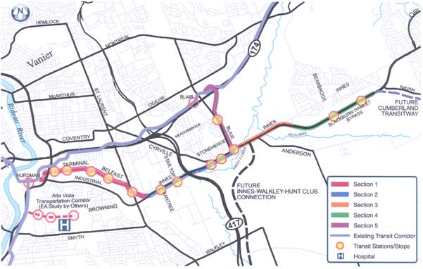
 The city's preferred route for a future east-end Transitway and new road would see Brian Coburn Boulevard extended to the west over NCC Greenbelt lands. (City of Ottawa)The city's preferred route for a future east-end Transitway and new road would see Brian Coburn Boulevard extended to the west over NCC Greenbelt lands. (City of Ottawa)
The NCC has written formal letters in the past couple of years telling the city it would not entertain a new road through Greenbelt farmland slightly further south. It doesn't want to break up the Greenbelt, especially near the environmentally sensitive Mer Bleue wetlands.
Despite that, city staff are recommending that transportation committee approve that route, known as Option 7, at its March 3 meeting.
Price tag of more than $300M
East-end city councillors insist that option makes the most sense long-term to ensure the growing population in south Orléans can get around, especially as more houses are built. They even publicly called out the NCC for not co-operating on the city's preferred option while making a recent council decision on an unrelated planning file.
City staff say after extensive study and consultation, Option 7 ranked highest. It would also cost hundreds of millions less, staff wrote: an estimated $128 million for the roadway, and $178 million for the Transitway.
Innes Coun. Laura Dudas said while environmental concerns are important to her, the route doesn't go near the Mer Bleue Bog and follows a hydro corridor.
She said it would also make it easier to some day link Orléans further south to Hunt Club Road. The Blackburn Hamlet Bypass is "beyond capacity," Dudas said, and adding a lane won't be enough for the 15,500 housing units to be built in south Orléans over the next decade.
"We definitely need a long-term solution," she said, expressing frustration that the NCC is "not willing to have a meaningful conversation with the city."
The NCC disagrees. Dufour says it wants to improve transportation linkages and is open to two other routes, including the city's second-ranked option.
The city had offered to swap 47 hectares of its land in order to get the required 42 hectares of Greenbelt property, but the NCC refused in December.
The Chapel Hill forest lands offered by the city surround homes and active roads that need to be maintained, the NCC said, which wouldn't compensate for the loss of high-quality farmland.
Short-term road improvements
While several community associations in the area support Option 7 route, others do not.
Pat Teolis, president of the Chateauneuf Community Association — one of the older subdivisions along Innes Road — said he and his neighbourhood support the NCC's mandate to protect greenspace.
 The second-ranked option for extending Brian Coburn Boulevard more closely resembles the decade-old plan and aligns the new corridor along the existing Blackburn Hamlet Bypass. (City of Ottawa)
Previous evaluations leaned toward the now second-place Option 1, Teolis said, which the NCC could support and would have less environmental impact.
"And now all of a sudden it's switched, and I find that very concerning," he said.
Even if the transportation committee approves the design for the east-end corridor, a federal environmental assessment would be required.
The NCC would ultimately need to approve the federal land transfer, which at this point appears unlikely.
Dudas knows that any road might not be built for many years. She points to $22 million the city hopes to spend in the meantime to improve travel times by widening two kilometres of Innes Road west of Blackburn Hamlet for transit lanes, and improving one intersection for buses.
https://www.cbc.ca/news/canada/ottaw...sign-1.6364816


 Prev
Prev


 Linear Mode
