Eurotrip Part 5
Amsterdam Urbanism
Paris: Outer Paris |
Central Paris |
Eiffel Tower |
Paris Transportation
Amsterdam: Urbanism |
Transportation
Bonus: TBD
Visiting Europe for the first time, my wife and I spent most of our time in Paris. But we wanted a train trip on the side to a city outside France, and after much debate we settled on Amsterdam. We choose it over other options because Amsterdam is simultaneously a great and interesting city, but vastly different from Paris: Smaller, newer, with rowhouses around canals, bikes, and trams rather than with apartment buildings around a subway. More funky and local. Amazing, but with different trappings than an alpha world city.
We did not, as all our friends assumed, go for the pot. And while nobody asked us if we went for the sex, we didn't partake in that local custom either. We did visit the Red Light District at night and enjoyed the show from the street, but were dissuaded from photographing the girls. If you'd like a taste of that experience,
a quick search on flickr shows lots of people didn't get the same message (NSFW).
Let's start.
We arrived via high-speed train at Amsterdam Centraal station, and immediately went out into Stationsplein, the plaza out front. The station and plaza were built at the entrance to Amsterdam's historic harbor, and cut the harbor off from the sea for large ships. So it's a very commanding location; the perfect spot from which to launch an exploration of the city.

Starting at the old harbor, it's easy to see the progressive waves of development in Amsterdam.
Look at a map of the city. In the center, the twisted streets of a pre-industrial town. But only a few blocks beyond, that pattern gives way to the canal belt neighborhoods from the 16th Century, with their neatly laid out grid of streets and waterways. A short walk further out, and the canal belt ends and more contemporary 19th Century neighborhoods begin. The demarcations are clear, if that's the sort of thing you notice on maps.
The little inner harbor is a jumble of activity, much of it tourist oriented. Old buildings line the original shore, while new buildings line what appears to be reclaimed land closer to the sea channel.

Beyond that, the main shopping street begins straight out from the rail station.


A block over, one of the few wide streets in the center city: Damrak.

The side streets are much, much narrower. But this is the old town. Most of Amsterdam isn't like this.


Built 1619. Jamestown was 12 years old. The Pilgrims were still a year away from arriving at Plymouth Rock. Given the location this must not have been the first building on the spot.

In the middle of the old city, Dam Square, Amsterdam's main central square.

full size
Fun fact #1: Amsterdam is so-named because it was the location of a dam on the Amstel River. Dam Square was the original dam.
Here's what it looked like in 1544.
Fun fact #2: It turns out Dutch is a very close language to English. I knew it was Germanic (like English) but didn't realize how close they are until I heard Dutch spoken on the streets. Seeing it in writing confuses things, but standing on the sidewalk overhearing 2 people nearby speaking Dutch, my wife and I could follow along no problem. Thus, Amster-dam for dam-on-the-Amstel makes perfect sense in both languages.
Anyway, the royal palace, on Dam Square.

Behind the palace, the post office. Now a shopping mall.


Amsterdam city flag:

Owl!

They're for moving things in and out of the upper floors. Attach a rope & pulley and go.

The old city isn't as dense with canals as the canal belt, but they're there.


Why not put a bar on a canal boat?

Muntplein with its Munttoren tower marks the boundary between the old city and the canal belt. The plaza is actually a large bridge.


Next to Muntplein, Amsterdam's famous flower market.

In case you're wondering.

The canal belt is the Amsterdam you usually see in photographs.


We saw this symbol all over and have no idea what it means. Anybody know?

It's not all historic.

On the east side of the city, Waterlooplein and its surrounds are quite modern. Not sure what the story is. War damage? Urban renewal?

It's very encouraging to see so many narrow new buildings. Narrow lots are very helpful to good urbanism, but modern land ownership (at least in the US) favors consolidation into fewer, larger properties.

The barely-visible building on the left, with the red shutters, was where Rembrandt van Rijn did much of his work.

On the west side, the house where Anne Frank and her companions spent more than two years in hiding.

Leidsestraat is the biggest shopping street through the canal zone.


1581 is 26 years before the first English colonists arrived in Jamestown, and nearly 200 years older than the oldest building still standing in Washington, DC.


A coffee shop is not always a coffee shop.

Near the outer edge of the canal zone, the Leidseplein square.


Squirrels!


Cross this last canal and leave the canal zone.

Houseboats.


Near the edge of the canal zone lies the Rijksmuseum, the Dutch national museum. Rijk is like "reich" in German, thus "reich-museum." Remember when I said we could follow a lot of Dutch even though we don't speak it? If you know some German in addition to your English then you're really set.

Lovely little garden outside the museum.


The water moves around, but if you stand in the right spot, you don't get wet.

Inside, each level is dedicated to a different time perdiod. Start near the bottom for the middle ages.
See the spot on his leg? Bubonic plague.

Moving up to the higher levels jumps forward in time. I learned a lot about Dutch history, of which I'd been embarrasingly ignorant.

Masters of realism, the Dutch painters. Look at the light.

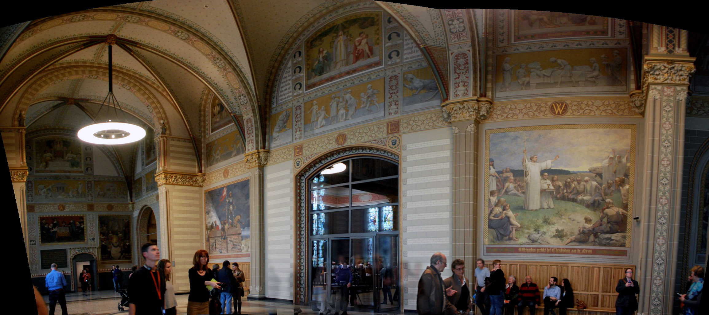
The main wing is like a cathedral.

full size

The centerpiece: Rembrandt's most famous painting, The Night Watch.

Beyond the canal zone puts us in Oud-West, the more 19th Century neighborhood that was home to our hotel.
In some ways, this part of Amsterdam was the most interesting to me. Structurally, it's really not very different from the northeast US. The pattern of brick rowhouses is similar, the width of streets is similar, it's all very similar. The only big difference is how space within the public right-of-way is divvied up.


We could do that. It's not so foreign. It looks like Adams Morgan DC or Boston's Back Bay, if their streets were reconfigured to worry less about cars.
On that note, see you in the next thread.


 Linear Mode
