HomeDiagramsDatabaseMapsForum About
     

Go Back   SkyscraperPage Forum > Regional Sections > Canada > Ontario > Ottawa-Gatineau > Transportation


Reply

 
Thread Tools Display Modes
     
     
  #1  
Old Posted Oct 29, 2014, 6:34 PM
waterloowarrior's Avatar
waterloowarrior waterloowarrior is offline
National Capital Region
 
Join Date: Nov 2005
Location: Eastern Ontario
Posts: 9,244
Airport Parkway and Lester Road Widening

http://ottawa.ca/airportparkway

Project overview
The City of Ottawa initiated the study to develop a Recommended Plan for the widening of the Airport Parkway between Brookfield Avenue to the Ottawa Macdonald-Cartier International Airport and the widening of Lester Road from the Airport Parkway to Bank Street.

Study Area


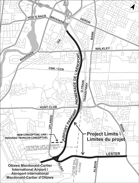
Study area map for the widening of the Airport Parkway between Brookfield Avenue to the Ottawa Macdonald-Cartier International Airport and the widening of Lester Road from the Airport Parkway to Bank Street.

Some aspects of the study will require examination of a broader area in order to address environmental effects; to co-ordinate with relevant ongoing studies and projects, and to study and identify tie-ins to the roadway network.

Rationale for widening the Airport Parkway and Lester Road
The Airport Parkway is a major north-south arterial road in the city. Along the corridor it connects with the neighbourhoods of Confederation Heights, Riverside Park, Ellwood, South Keys, Hunt Club, Gloucester, Uplands and Blossom Park at the Brookfield, Walkley, Hunt Club and Lester interchanges.

Rapid growth in the communities south of Hunt Club Road, including Leitrim, Riverside South and Greely has increased traffic volumes on the Airport Parkway, leading to congestion during the peak commuting periods. Future development of the airport lands, with a planned airport expansion as well as commercial development will also put increased pressure on these corridors. The establishment of the Ernst & Young Centre trade show facility at the northwest corner of the Airport Parkway and Uplands Road has further increased traffic in the area of the Lester/Albion Road corridor.

This Environmental Assessment (EA) study will take urban and rural growth, the development of the Ernst & Young Centre, as well as the Rideau Carleton Raceway operations as a source of demand effect on the Airport Parkway into consideration.

Study Process
The study is being conducted in accordance with Ontario's EA Act, fulfilling requirements as a Municipal Class EA process for Schedule C projects. The City must consider alternative designs for the project, undertake public and agency consultation, assess the potential environmental effects of the Recommended Plan and identify measures to mitigate these impacts.

The study will also address potential implications of federal and National Capital Commission (NCC) properties and the potential for federal permits and funding to implement the project.

As part of the study process, an Environmental Study Report (ESR) will be prepared for public review. Following the public review period, the project will be considered to have EA approval and may proceed to implementation once financing is in place.

Study Timeline
The EA process requires a comprehensive consultation program involving many stakeholders, including the City of Ottawa, the Airport, the NCC, approval and regulatory agencies, local community associations and businesses, special advisory and interest groups and members of the public. The study is expected to take 24 months to complete.

Last edited by waterloowarrior; Jan 14, 2015 at 4:31 PM.
Reply With Quote
     
     
  #2  
Old Posted Oct 29, 2014, 8:19 PM
Richard Eade Richard Eade is offline
Registered User
 
Join Date: Mar 2008
Location: Nepean
Posts: 1,953
Anyone else find it fascinating, but totally unsurprising, that the City seems to have changed this project from adding a transit/taxi lane per direction between Hunt Club and Lester, to simply adding full lanes for general traffic the entire length of the Parkway and along Lester. I knew it would happen, but I thought they would play their game a little bit longer.

Well, if they are doubling the road capacity to the south end, what is the justification for extending the Trillium Line (formerly the O-Train) any further south?

Also, now that we will be funneling a LOT more traffic up the widened Airport Parkway, err, rather, Expressway, where will it all go when it hits Bronson? My bet is that the City will make a wider (northbound) connection between Bronson and Riverside and run the traffic up Riverside to an extension of Nicholas. Going south might require more thought to get a smooth flow from Riverside up to Bronson; maybe a signal under the Bronson Bridge will be necessary.
Reply With Quote
     
     
  #3  
Old Posted Oct 29, 2014, 8:24 PM
Aylmer's Avatar
Aylmer Aylmer is offline
Still optimistic
 
Join Date: Nov 2007
Location: Montreal (C-D-N) / Ottawa (Aylmer)
Posts: 5,383
City of Ottawa.


What.


is so hard.


to grasp.


about.


INDUCED.


DEMAND?????


It's called the fundamental law of traffic for a reason. I mean, we don't build bridges without testing them against the fundamental laws of physics, do we? (EDIT: Well... Airport Parkway Ped Bridge)
__________________
I've always struggled with reality. And I'm pleased to say that I won.
Reply With Quote
     
     
  #4  
Old Posted Oct 29, 2014, 9:27 PM
1overcosc's Avatar
1overcosc 1overcosc is offline
Registered User
 
Join Date: Jun 2013
Location: Kingston, Ontario
Posts: 11,482
Relax. The City of Ottawa can't afford an all out widening of the Parkway + Lester Road. It's not funded within the ~$800M (forget the exact number) budget they set out for road widenings between 2014 and 2031. This EA is clearly a 'concept' EA, sort of like how the Orleans LRT EA covers all the way out to Trim but the project funding only goes to Place D'Orleans.
Reply With Quote
     
     
  #5  
Old Posted Oct 29, 2014, 10:25 PM
waterloowarrior's Avatar
waterloowarrior waterloowarrior is offline
National Capital Region
 
Join Date: Nov 2005
Location: Eastern Ontario
Posts: 9,244
Quote:
Originally Posted by 1overcosc View Post
Relax. The City of Ottawa can't afford an all out widening of the Parkway + Lester Road. It's not funded within the ~$800M (forget the exact number) budget they set out for road widenings between 2014 and 2031. This EA is clearly a 'concept' EA, sort of like how the Orleans LRT EA covers all the way out to Trim but the project funding only goes to Place D'Orleans.
It is in the affordable network

http://documents.ottawa.ca/sites/doc...nts/tmp_en.pdf

Affordable Road Network
Phase 1 2014-2019 Airport Parkway (1) Widen from two to four lanes between Brookfield Road and Hunt Club Road

Phase 2: 2020-2025
Southeast Lester Road Widen from two to four lanes between Airport Parkway and Bank Street

Phase 3: 2026-2031
Southeast Airport Parkway (2) Widen from two to four lanes between Hunt Club Road and MacDonald-Cartier International Airport

Exhibit 6.2 2031 Affordable RTTP Network Projects – Transit Priority
Airport Parkway Hunt Club Road to MacDonald-Cartier Intl. Airport
Peak period bus lanes made available by road widening project

Airport Parkway
(Affordable Network only)
Bus / high occupancy vehicle (HOV) lanes between Hunt Club Road and MacDonald-Cartier International Airport. With the widening of the Airport Parkway to 4 lanes, the outside lanes will be used
for transit, taxis, and HOV’s In lieu of rapid transit, improves transit access to MacDonald-Cartier International Airport
Reply With Quote
     
     
  #6  
Old Posted Oct 29, 2014, 10:58 PM
MaxHeadroom's Avatar
MaxHeadroom MaxHeadroom is offline
Registered User
 
Join Date: Oct 2009
Posts: 189
Quote:
Originally Posted by Richard Eade View Post
Anyone else find it fascinating, but totally unsurprising, that the City seems to have changed this project from adding a transit/taxi lane per direction between Hunt Club and Lester, to simply adding full lanes for general traffic the entire length of the Parkway and along Lester. I knew it would happen, but I thought they would play their game a little bit longer.
Those roads are already over capacity at peak periods. People that live in the south like Greely, Osgoode, and Vernon don't have access to transit and must to drive into the city. And reserved lanes are generally ignored by many drivers because there is zero enforcement. Case in point: https://www.youtube.com/watch?v=4eMlT9EdxRM
Reply With Quote
     
     
  #7  
Old Posted Oct 29, 2014, 11:26 PM
1overcosc's Avatar
1overcosc 1overcosc is offline
Registered User
 
Join Date: Jun 2013
Location: Kingston, Ontario
Posts: 11,482
^ I don't think it's common. I've never seen cars attempt to drive in the Carling Avenue bus lanes between Booth and Bronson and I'm through there every single day. I suspect this video was likely taken shortly after the bus lane on the bridge opened and people weren't used to it.

In any case, that's not an argument against having bus lanes.. it's an argument in favour of stricter enforcement and driver education. This is the 21st century, if people driving in bus lanes became a problem that can solved immediately with auto-ticketing cameras.

Also, why should we be building roads for the benefit of people who live in places like Greely or Metcalfe? If you want to live in the middle of nowhere and drive to the city every day you should expect to sit in gridlock and not expect the city to put millions into facilitating your unsustainable exurban lifestyle. Furthermore, we should not be building new roads to make it easier for people to move out to the country and drive in.
Reply With Quote
     
     
  #8  
Old Posted Oct 30, 2014, 12:18 AM
1overcosc's Avatar
1overcosc 1overcosc is offline
Registered User
 
Join Date: Jun 2013
Location: Kingston, Ontario
Posts: 11,482
Quote:
Originally Posted by waterloowarrior View Post
It is in the affordable network

http://documents.ottawa.ca/sites/doc...nts/tmp_en.pdf

Affordable Road Network
Phase 1 2014-2019 Airport Parkway (1) Widen from two to four lanes between Brookfield Road and Hunt Club Road

Phase 2: 2020-2025
Southeast Lester Road Widen from two to four lanes between Airport Parkway and Bank Street

Phase 3: 2026-2031
Southeast Airport Parkway (2) Widen from two to four lanes between Hunt Club Road and MacDonald-Cartier International Airport

Exhibit 6.2 2031 Affordable RTTP Network Projects – Transit Priority
Airport Parkway Hunt Club Road to MacDonald-Cartier Intl. Airport
Peak period bus lanes made available by road widening project

Airport Parkway
(Affordable Network only)
Bus / high occupancy vehicle (HOV) lanes between Hunt Club Road and MacDonald-Cartier International Airport. With the widening of the Airport Parkway to 4 lanes, the outside lanes will be used
for transit, taxis, and HOV’s In lieu of rapid transit, improves transit access to MacDonald-Cartier International Airport
Well colour me stupid, looks like I misremembered the TMP.
Reply With Quote
     
     
  #9  
Old Posted Oct 30, 2014, 1:32 AM
MaxHeadroom's Avatar
MaxHeadroom MaxHeadroom is offline
Registered User
 
Join Date: Oct 2009
Posts: 189
Quote:
Originally Posted by 1overcosc View Post
^ I don't think it's common. I've never seen cars attempt to drive in the Carling Avenue bus lanes between Booth and Bronson and I'm through there every single day. I suspect this video was likely taken shortly after the bus lane on the bridge opened and people weren't used to it.
That video was taken on Monday October 27 2014. People are very used to the fact they can use the bus lane without any consequence.
Reply With Quote
     
     
  #10  
Old Posted Oct 30, 2014, 12:26 PM
Mulder Mulder is offline
Registered User
 
Join Date: Mar 2013
Posts: 124
Quote:
Originally Posted by MaxHeadroom View Post
That video was taken on Monday October 27 2014. People are very used to the fact they can use the bus lane without any consequence.
Yup, I've even seen a guy use it Sunday morning when traffic was light to non-existent.

Quote:
Originally Posted by 1overcosc View Post
^ I don't think it's common. I've never seen cars attempt to drive in the Carling Avenue bus lanes between Booth and Bronson and I'm through there every single day. I suspect this video was likely taken shortly after the bus lane on the bridge opened and people weren't used to it.

I only use Carling Ave as a way home if 417 is backed up. I usually don't go all the way to Bronson (usually go Queen Elizabeth to Lakeside ave) as it's always backed up and people don't know how to leave space, especially going up a hill when I drive a standard.

There is little incentive to cheat here because of the bulb at Cambridge but those turning on Cambridge do it all the time (I've even done it once)
Reply With Quote
     
     
  #11  
Old Posted Oct 30, 2014, 1:33 PM
TransitZilla TransitZilla is online now
Registered User
 
Join Date: Dec 2006
Posts: 2,740
Quote:
Originally Posted by MaxHeadroom View Post
That video was taken on Monday October 27 2014. People are very used to the fact they can use the bus lane without any consequence.
This is sadly very common on the Heron Rd bridge, at least westbound.

Drivers seem to generally respect other bus lanes in the city but not this one.

Before the bridge reconstruction, the right lane was not a bus lane until very close to the Prince of Wales intersection, so cars turning right onto Prince of Wales could use it to bypass the queue of vehicles heading straight. This isn't allowed anymore with the bus lane, but drivers are acting as if it is still, even though it has been this way for at least a year.
Reply With Quote
     
     
  #12  
Old Posted Oct 30, 2014, 1:38 PM
MountainView MountainView is offline
Registered User
 
Join Date: Feb 2011
Posts: 1,838
Quote:
Originally Posted by MaxHeadroom View Post
That video was taken on Monday October 27 2014. People are very used to the fact they can use the bus lane without any consequence.
I tried to take this way to work the other day to see if it was faster/comparable to my normal route. I was going west on Heron towards POW, traffic backed up to before the bridge. ANY ONE who wants to turn right at POW uses the bus lanes as a long right turn lane. I did it myself. The light cycle is way too short for Heron/Baseline and thus traffic backs up. I figured if a police officer was over the bridge and wanted to pull us all over (basically a constant flow of cars doing this) then c'est la vie.
Reply With Quote
     
     
  #13  
Old Posted Oct 30, 2014, 2:24 PM
1overcosc's Avatar
1overcosc 1overcosc is offline
Registered User
 
Join Date: Jun 2013
Location: Kingston, Ontario
Posts: 11,482
^ Huh. So this is actually a problem on that bridge. City really should put auto-ticketing cameras up. Could be a nice revenue booster, at least in the short term before people learn they can't get away with it and then stop.

On the topic of auto-ticketing cameras I'd like to see the city put those at bus stops (have 20 cameras, move them around between 100 stops) to nab drivers who fail to yield to buses. That's another common violation.
Reply With Quote
     
     
  #14  
Old Posted Oct 30, 2014, 3:54 PM
MountainView MountainView is offline
Registered User
 
Join Date: Feb 2011
Posts: 1,838
Quote:
Originally Posted by 1overcosc View Post
^ Huh. So this is actually a problem on that bridge. City really should put auto-ticketing cameras up. Could be a nice revenue booster, at least in the short term before people learn they can't get away with it and then stop.

On the topic of auto-ticketing cameras I'd like to see the city put those at bus stops (have 20 cameras, move them around between 100 stops) to nab drivers who fail to yield to buses. That's another common violation.
If the Heron Bridge lane was a shared Right Turn Only / Bus Lane it would make so much more sense in a traffic flow perspective and wouldn't slow the flow of buses either. It is only an issue 7:30-9:30am and 4-6pm.

And yes, when you're driving 60km/h and the bus sticks its signal on to merge back in and your 40 feet away from the bus it's nearly impossible to safely slow down (yield) to let the bus merge back in.

As someone who takes the bus 50/50 compared to car I would prefer them to put cameras inside the buses to stop vandalism.
Reply With Quote
     
     
  #15  
Old Posted Oct 30, 2014, 4:01 PM
Uhuniau Uhuniau is online now
Registered User
 
Join Date: Jan 2010
Posts: 8,040
Quote:
Originally Posted by 1overcosc View Post
^ Huh. So this is actually a problem on that bridge. City really should put auto-ticketing cameras up. Could be a nice revenue booster, at least in the short term before people learn they can't get away with it and then stop.

On the topic of auto-ticketing cameras I'd like to see the city put those at bus stops (have 20 cameras, move them around between 100 stops) to nab drivers who fail to yield to buses. That's another common violation.
Red-light camera rage was a significant factor in getting the Mike Harris PC's elected in 1995.
Reply With Quote
     
     
  #16  
Old Posted Oct 30, 2014, 6:10 PM
TransitZilla TransitZilla is online now
Registered User
 
Join Date: Dec 2006
Posts: 2,740
Quote:
Originally Posted by Uhuniau View Post
Red-light camera rage was a significant factor in getting the Mike Harris PC's elected in 1995.
But that was 20 years ago. Maybe things have changed.
Reply With Quote
     
     
  #17  
Old Posted Oct 30, 2014, 6:27 PM
1overcosc's Avatar
1overcosc 1overcosc is offline
Registered User
 
Join Date: Jun 2013
Location: Kingston, Ontario
Posts: 11,482
Hey, I just realized, this is another reason to favour the use of median BRT for Baseline, March, etc. instead of curbside BRT, as median BRT is much harder and much less 'natural' for pesky motorists to invade.
Reply With Quote
     
     
  #18  
Old Posted Oct 30, 2014, 6:27 PM
HighwayStar's Avatar
HighwayStar HighwayStar is online now
Registered User
 
Join Date: Jul 2014
Location: PHX (by way of YOW)
Posts: 1,191
Quote:
Originally Posted by Uhuniau View Post
Red-light camera rage was a significant factor in getting the Mike Harris PC's elected in 1995.
The Mike Harris election issue was "Photo Radar"... which was essentially speed-trap cameras along the 400 series highways. I remember there was even talk at the time that if they lowered the sensitivity to 107 km/h (or something similar) it would raise $XX million more. The whole program was widely seen as a cash grab as opposed to safety related.

I think most people would differentiate between Photo Radar for "speeding", and red-light cameras... which arguably serve a much more noble purpose.
Reply With Quote
     
     
  #19  
Old Posted Oct 30, 2014, 7:10 PM
ars ars is offline
Registered User
 
Join Date: Feb 2013
Location: Ottawa
Posts: 472
I saw people using the bus lane on the 417 westbound when Moodie to Eagleson was reduced to 2 lanes. The police eventually caught on and people started getting pulled over.
Reply With Quote
     
     
  #20  
Old Posted Oct 30, 2014, 8:50 PM
MaxHeadroom's Avatar
MaxHeadroom MaxHeadroom is offline
Registered User
 
Join Date: Oct 2009
Posts: 189
Quote:
Originally Posted by 1overcosc View Post
Hey, I just realized, this is another reason to favour the use of median BRT for Baseline, March, etc. instead of curbside BRT, as median BRT is much harder and much less 'natural' for pesky motorists to invade.
But this creates a whole new set of problems for vehicles turning left and potential interferences particularly with pedestrians who have to get on and off buses. Buses still end up waiting at traffic lights so there is no improvement to commuting times.
Reply With Quote
     
     
This discussion thread continues

Use the page links to the lower-right to go to the next page for additional posts
 
 
Reply

Go Back   SkyscraperPage Forum > Regional Sections > Canada > Ontario > Ottawa-Gatineau > Transportation
Forum Jump


Forum Jump


All times are GMT. The time now is 5:46 PM.

     
SkyscraperPage.com - Archive - Privacy Statement - Top

Powered by vBulletin® Version 3.8.7
Copyright ©2000 - 2024, vBulletin Solutions, Inc.