HomeDiagramsDatabaseMapsForum About
     

Go Back   SkyscraperPage Forum > Regional Sections > Canada


Reply

 
Thread Tools Display Modes
     
     
  #1861  
Old Posted Jan 25, 2020, 5:51 AM
Dengler Avenue's Avatar
Dengler Avenue Dengler Avenue is offline
Road Engineer Wannabe
 
Join Date: Sep 2017
Location: Côté Ouest de la Rivière des Outaouais
Posts: 8,236
The green maple leaf shield? Yes!

We in Ontario are a bit more creative. For Highway 17 through Upper Ottawa Valley, we will have a separate King’s Highways Shield for the number 17. Then, in our TCH shield, we imprint “Upper Ottawa Valley Route”.

Not always though. Sometimes we only show Highway 17 and won’t even bother with the TCH shield.

N.B. has the number 2 imprinted in the TCH shield.
__________________
My Proposal of TCH Twinning in Northern Ontario
Disclaimer: Most of it is pure pie in the sky, so there's no need to be up in the arm about it.
Reply With Quote
     
     
  #1862  
Old Posted Jan 25, 2020, 6:55 AM
Loco101's Avatar
Loco101 Loco101 is offline
Registered User
 
Join Date: May 2013
Location: Timmins, Northern Ontario
Posts: 7,715
Quote:
Originally Posted by craner View Post
It’s disappointing the TCH is not numbered as #1 from coast to coast. You would still have TCH #16 branch off north in Manitoba and you could have some multiple routes in the east as well but my OCD wants at least one complete route from coast to coast numbered as #1.
Do they even use the green signage with the maple leaf in the east ?
Man I wish we had a properly funded national network of highways with a baseline standard.
End of my rant.
Ontario and Quebec have their regular provincial highway signs. But Ontario usually puts the Trans-Canada shield below the highway sign and Quebec has a separate shield sign beside the highway sign that says "Transcanadienne" and sometimes the sign is just on its own. Both provinces use the same maple leaf design as found in the other provinces but they don't put the highway number in them.

Both Ontario and Quebec have alternate routes of the Trans-Canada. Near me is Hwy 11 which is the Northern Route. There are also a few other routes in other regions within Ontario. Quebec has a Northern Route which is Route 117 which changes to Hwy 66 in Ontario and connects to Hwy 11.
Reply With Quote
     
     
  #1863  
Old Posted Jan 25, 2020, 1:07 PM
ghYHZ ghYHZ is offline
Registered User
 
Join Date: Aug 2007
Location: Antigonish NS
Posts: 496
Quote:
Originally Posted by craner View Post
It’s disappointing the TCH is not numbered as #1 from coast to coast...….Do they even use the green signage with the maple leaf in the east ?
Here in Nova Scotia it's the 104, 105 and 106 and collectively called the “Trans Canada” by everyone. The Green Maple Leaf sign is used along with the respective number. I can just imagine the cost to change signs to an NS 'TCH1'....let alone addresses and everything else tied to it for no practical reason.

Heading west.....when I reach Fort Lawrence NS......TCH104 just continues into New Brunswick and becomes TCH2. Most wouldn’t even notice. It’s not like you will have to come off and go looking for New Brunswick's TCH2. It’s still a green & white TCH shield.....only the number changes and again, most wouldn’t notice.

Here's Nova Scotia:


This sign (below) is an anomaly. A Nova Scotia 'Provincial' 106 sign is used here instead of the Green TCH Shields that are used elsewhere. This is the short 18 km spur from TCH104 at Mt. William (New Glasgow) to the Prince Edward Island Ferry at Caribou NS.


New Brunswick....It's TCH2 and there's also TCH16....the spur to the Confederation Bridge.


Quebec....the Green Shield along with the Provincial sign. This is at Riviere-du-Loup where Autoroute 20 splits and 85 & 185 head to the Maritimes:


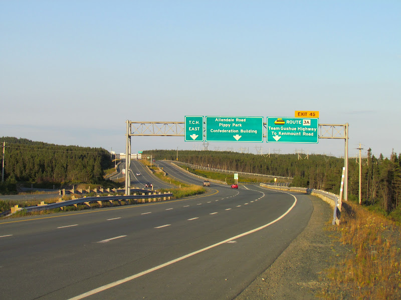
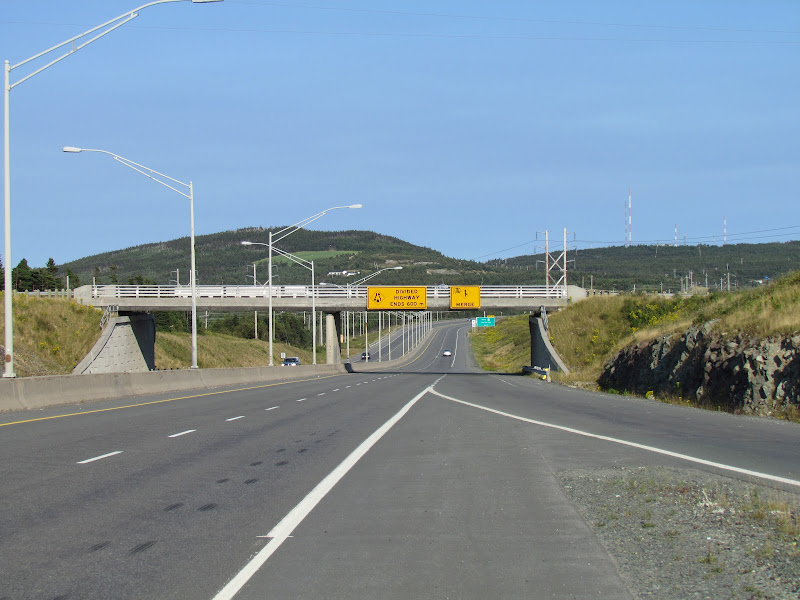
Prince Edward Island and Newfoundland:


And BTW here's the eastern end of the Trans Canada (7200 km from Victoria) in St. John's where it tapers to two lanes at Logy Bay Road......and the most easterly section of freeway in North America:


Last edited by ghYHZ; Jan 25, 2020 at 1:45 PM.
Reply With Quote
     
     
  #1864  
Old Posted Jan 25, 2020, 2:04 PM
Dengler Avenue's Avatar
Dengler Avenue Dengler Avenue is offline
Road Engineer Wannabe
 
Join Date: Sep 2017
Location: Côté Ouest de la Rivière des Outaouais
Posts: 8,236
If anything, the historical Highway 2 (Windsor, ON ~ Halifax, N.S.) may be better known among the eastern provinces. Sadly enough, in Quebec, the only trace of that is the Old Route 2 (l’Ancienne Route 2) which spurs off Route 185 near Whiteworth F.N.
__________________
My Proposal of TCH Twinning in Northern Ontario
Disclaimer: Most of it is pure pie in the sky, so there's no need to be up in the arm about it.
Reply With Quote
     
     
  #1865  
Old Posted Jan 25, 2020, 2:14 PM
q12's Avatar
q12 q12 is offline
Registered User
 
Join Date: Mar 2008
Location: Halifax
Posts: 4,529
National Highway System

Reply With Quote
     
     
  #1866  
Old Posted Jan 25, 2020, 2:28 PM
q12's Avatar
q12 q12 is offline
Registered User
 
Join Date: Mar 2008
Location: Halifax
Posts: 4,529
Here is basically what is twinned full controlled access with interchanges in the Maritimes.


It's worth noting that nearly the entire length of the 101 in Nova Scotia is controlled access with interchanges (Super 2). The 101 is over 300 km length and only has a 20 km section beyond Digby that has not been made Super 2.
Reply With Quote
     
     
  #1867  
Old Posted Jan 25, 2020, 2:50 PM
ghYHZ ghYHZ is offline
Registered User
 
Join Date: Aug 2007
Location: Antigonish NS
Posts: 496
Quote:
Originally Posted by Dengler Avenue View Post
If anything, the historical Highway 2 (Windsor, ON ~ Halifax, N.S.) may be better known among the eastern provinces......
Here in Nova Scotia you can still drive old Trunk 2 (and still signed as such)....nearly all the way from the NS/NB border into downtown Halifax.


And just over the border on the New Brunswick side you can still see iterations of NB Route 2 crossing the Tantamar Marshes to Sackville NB. On the left the original highway.....middle: the highway constructed in the 1960s and on the far right the current, divided TCH2.


The old alignments are shown as Aulac Road and see how the 3 alignments come together to cross the marshes here along with CN's parallel transcontinental mainline:

https://goo.gl/maps/ctCJ7AgCFov9bzi28

Last edited by ghYHZ; Jan 25, 2020 at 3:01 PM.
Reply With Quote
     
     
  #1868  
Old Posted Jan 25, 2020, 2:57 PM
Dengler Avenue's Avatar
Dengler Avenue Dengler Avenue is offline
Road Engineer Wannabe
 
Join Date: Sep 2017
Location: Côté Ouest de la Rivière des Outaouais
Posts: 8,236
Even from Google Map’s Satellite View, one can see that Aulac Road used to carry N.B.-2 across the river. That bridge seemed taken out long ago.
__________________
My Proposal of TCH Twinning in Northern Ontario
Disclaimer: Most of it is pure pie in the sky, so there's no need to be up in the arm about it.
Reply With Quote
     
     
  #1869  
Old Posted Jan 25, 2020, 3:40 PM
q12's Avatar
q12 q12 is offline
Registered User
 
Join Date: Mar 2008
Location: Halifax
Posts: 4,529
I tried to update this 10 year old highway map showing currently twinned sections (including Highway 103 section opening this spring between Tantallon and Ingramport)

Reply With Quote
     
     
  #1870  
Old Posted Jan 25, 2020, 4:06 PM
ghYHZ ghYHZ is offline
Registered User
 
Join Date: Aug 2007
Location: Antigonish NS
Posts: 496
Quote:
Originally Posted by q12 View Post
I tried to update this 10 year old highway map showing currently twinned sections (including Highway 103 section opening this spring between Tantallon and Ingramport)
Great Job.....Thanks! (Antigonish is spot on!)
Reply With Quote
     
     
  #1871  
Old Posted Jan 25, 2020, 5:24 PM
MonctonRad's Avatar
MonctonRad MonctonRad is offline
Wildcats Rule!!
 
Join Date: Jun 2008
Location: Moncton NB
Posts: 34,636
Since we are on the topic. I have created a map showing the full extent of New Brunswick's fully grade separated, limited access divided highways.


This encompasses all of Highways 1, 2 & 95 and portions of Highways 7,11 & 15 for a total inventory of approximately 800 km.

NB-95 is a short connector highway at Woodstock leading to I-95 at the Maine border. To maintain consistency with the standards of NB-2 (TCH) and I-95, this highway is built to full freeway standards.

This leads to an interesting question. Is there anywhere else in Canada where a connector road to the US interstate system uses the same numbering system as the interstate highway to which it is connecting??? I don't think so personally. I think NB-95 is unique in this regard.
__________________
Go 'Cats Go
Reply With Quote
     
     
  #1872  
Old Posted Jan 25, 2020, 5:38 PM
PEI highway guy PEI highway guy is offline
Registered User
 
Join Date: Oct 2016
Location: Summerside, PE
Posts: 597
Quote:
Originally Posted by MonctonRad View Post
Since we are on the topic. I have created a map showing the full extent of New Brunswick's fully grade separated, limited access divided highways.


This encompasses all of Highways 1, 2 & 95 and portions of Highways 7,11 & 15 for a total inventory of approximately 800 km.

NB-95 is a short connector highway at Woodstock leading to I-95 at the Maine border. To maintain consistency with the standards of NB-2 (TCH) and I-95, this highway is built to full freeway standards.

This leads to an interesting question. Is there anywhere else in Canada where a connector road to the US interstate system uses the same numbering system as the interstate highway to which it is connecting??? I don't think so personally. I think NB-95 is unique in this regard.
Highway 7 is twinned halfway between SJ and Oromocto, (Freddy)? I was not aware. Thanks for sharing.
Reply With Quote
     
     
  #1873  
Old Posted Jan 25, 2020, 5:40 PM
Dengler Avenue's Avatar
Dengler Avenue Dengler Avenue is offline
Road Engineer Wannabe
 
Join Date: Sep 2017
Location: Côté Ouest de la Rivière des Outaouais
Posts: 8,236
N.B.-7 is a weird one. Twinned for ~1.5 km around the entrance to C.F.B. Gagetown, around Welsford then near N.B.-1. Otherwise, it’s mostly 2-lane or features a 2+1 configuration here and there.
__________________
My Proposal of TCH Twinning in Northern Ontario
Disclaimer: Most of it is pure pie in the sky, so there's no need to be up in the arm about it.
Reply With Quote
     
     
  #1874  
Old Posted Jan 25, 2020, 5:44 PM
MonctonRad's Avatar
MonctonRad MonctonRad is offline
Wildcats Rule!!
 
Join Date: Jun 2008
Location: Moncton NB
Posts: 34,636
Quote:
Originally Posted by PEI highway guy View Post
Highway 7 is twinned halfway between SJ and Oromocto, (Freddy)? I was not aware. Thanks for sharing.
It is divided north from NB-1 to Grand Bay-Westfield, where it serves as a suburban bypass and commuter highway. There is also a fairly long divided segment in it's mid portion as it passes through the southern part of CFB Gagetown. I have a feeling that a large portion of the funding of this may have come from the feds. There is an interchange here leading to a service road on the base. I think the province convinced the feds to cough up some funding to "future proof" this interchange for the eventuality of full twinning of Highway 7. This segment of divided highway is probably about 12-15 km in length.
__________________
Go 'Cats Go
Reply With Quote
     
     
  #1875  
Old Posted Jan 25, 2020, 5:44 PM
PEI highway guy PEI highway guy is offline
Registered User
 
Join Date: Oct 2016
Location: Summerside, PE
Posts: 597
Quote:
Originally Posted by Dengler Avenue View Post
N.B.-7 is a weird one. Twinned for ~1.5 km around the entrance to C.F.B. Gagetown, around Welsford then near N.B.-1. Otherwise, it’s mostly 2-lane or features a 2+1 configuration here and there.
I knew they had built the Welsford bypass. I just thought it was a Super 2 highway not a twinning. I have driven 7 to Welsford from SJ, however, it has been years.
Reply With Quote
     
     
  #1876  
Old Posted Jan 25, 2020, 5:52 PM
MonctonRad's Avatar
MonctonRad MonctonRad is offline
Wildcats Rule!!
 
Join Date: Jun 2008
Location: Moncton NB
Posts: 34,636
I just went onto Google Earth to measure the divided segment of NB-7 at CFB Gagetown and I overestimated it's length. The divided segment is 4.5 km long.
__________________
Go 'Cats Go
Reply With Quote
     
     
  #1877  
Old Posted Jan 25, 2020, 6:00 PM
Dengler Avenue's Avatar
Dengler Avenue Dengler Avenue is offline
Road Engineer Wannabe
 
Join Date: Sep 2017
Location: Côté Ouest de la Rivière des Outaouais
Posts: 8,236
Are we talking about Exit 51 here? I just realized it’s longer than I expected.
__________________
My Proposal of TCH Twinning in Northern Ontario
Disclaimer: Most of it is pure pie in the sky, so there's no need to be up in the arm about it.
Reply With Quote
     
     
  #1878  
Old Posted Jan 25, 2020, 6:22 PM
MonctonRad's Avatar
MonctonRad MonctonRad is offline
Wildcats Rule!!
 
Join Date: Jun 2008
Location: Moncton NB
Posts: 34,636
Quote:
Originally Posted by Dengler Avenue View Post
Are we talking about Exit 51 here? I just realized it’s longer than I expected.
Indeed.
__________________
Go 'Cats Go
Reply With Quote
     
     
  #1879  
Old Posted Jan 25, 2020, 6:33 PM
Franco401 Franco401 is offline
Registered User
 
Join Date: Jan 2014
Location: Fredericton
Posts: 1,205
Quote:
Originally Posted by Dengler Avenue View Post
N.B.-7 is a weird one. Twinned for ~1.5 km around the entrance to C.F.B. Gagetown, around Welsford then near N.B.-1. Otherwise, it’s mostly 2-lane or features a 2+1 configuration here and there.
Route 7 is unique in that it has absolutely no local traffic along a huge section, and no ability to ever have any local traffic. A divided 2+1 is probably the closest it'll ever get to a true freeway through CFB Gagetown, but in the long run it will likely get done from the end of the Welsford Bypass south to the city limit and an interchange should be built at Geary.
Reply With Quote
     
     
  #1880  
Old Posted Jan 26, 2020, 2:35 AM
isaidso isaidso is offline
The New Republic
 
Join Date: Dec 2008
Location: United Provinces of America
Posts: 10,809
All the maps are great. Thanks everyone who posted.
__________________
World's First Documented Baseball Game: Beachville, Ontario, June 4th, 1838.
World's First Documented Gridiron Game: University College, Toronto, November 9th, 1861.
Hamilton Tiger-Cats since 1869 & Toronto Argonauts since 1873: North America's 2 oldest pro football teams
Reply With Quote
     
     
This discussion thread continues

Use the page links to the lower-right to go to the next page for additional posts
 
 
Reply

Go Back   SkyscraperPage Forum > Regional Sections > Canada
Forum Jump


Forum Jump


All times are GMT. The time now is 10:51 PM.

     
SkyscraperPage.com - Archive - Privacy Statement - Top

Powered by vBulletin® Version 3.8.7
Copyright ©2000 - 2024, vBulletin Solutions, Inc.