HomeDiagramsDatabaseMapsForum About
     

Go Back   SkyscraperPage Forum > Regional Sections > United States > Mountain West


Reply

 
Thread Tools Display Modes
     
     
  #1781  
Old Posted Jun 17, 2009, 12:13 AM
John Martin's Avatar
John Martin John Martin is offline
Registered User
 
Join Date: Jan 2009
Posts: 1,195
Either that or he stayed in Salt Lake a little while longer
Reply With Quote
     
     
  #1782  
Old Posted Jun 17, 2009, 2:18 PM
shakman's Avatar
shakman shakman is offline
Chairman
 
Join Date: Jun 2002
Location: PRMD - People's Republic of Maryland
Posts: 2,687
Are the rail tracks, or any part of, shared by any other rails (i.e. Amtrak, freight rail)? It may explain the time issue.

How many stops are there towards Orem?
__________________
"I measure the value of life not by how much I have, instead by what I have done.

-sb
Reply With Quote
     
     
  #1783  
Old Posted Jun 17, 2009, 3:35 PM
arkhitektor arkhitektor is offline
Registered User
 
Join Date: Feb 2005
Location: Clearfield, UT
Posts: 1,784
Quote:
Originally Posted by shakman View Post
Are the rail tracks, or any part of, shared by any other rails (i.e. Amtrak, freight rail)? It may explain the time issue.

How many stops are there towards Orem?
FrontRunner uses its own tracks on a right-of-way adjacent to the existing freight tracks, but does not share track with any other railroad, except for a portion of track between Ogden and Pleasant View (the northernmost station with only limited service)

Most of the route is single-track, which means that trains occasionally have to wait on a siding track or at a station for trains headed the other direction to pass. UTA has recently been testing a new schedule on Saturdays that improves the passing sequences and will take 7 minutes off of the total trip time. I believe that the new schedule takes effect in August.
Reply With Quote
     
     
  #1784  
Old Posted Jun 17, 2009, 5:24 PM
Orlando's Avatar
Orlando Orlando is offline
Registered User
 
Join Date: Nov 2007
Location: Salt Lake City, UT
Posts: 4,129
I've taken Front Runner from SLC to Ogden, too, and it was a lot slower than I anticipated. There are a few spots where it gets up to 75, but it seemed to go slow over a lot of places, like curves, road intersections, etc. It doesn't make sense to me why it has to go so slow for so much of the time. It really takes the advantage of riding Front Runner, except for maybe really when there is very bad rush hour traffice on the freeway.
Reply With Quote
     
     
  #1785  
Old Posted Jun 17, 2009, 8:24 PM
Future Mayor's Avatar
Future Mayor Future Mayor is offline
Vote for me in 2019!
 
Join Date: Jun 2007
Location: Salt Lake City, UT
Posts: 4,803
It should be noted that UTA owns enough right-of-way to install a second track. When the demand is there they will move forward with the process of installing the second track, so that north and south bound each have their own track and won't have to wait for the other train to pass.

They will have the same width right-of-way all the way to Payson, to enable a future second track on Front Runner south as well.
Reply With Quote
     
     
  #1786  
Old Posted Jun 25, 2009, 8:49 PM
arkhitektor arkhitektor is offline
Registered User
 
Join Date: Feb 2005
Location: Clearfield, UT
Posts: 1,784
So, I read this week that the WRFC has selected a preferred alignment for the Weber County segment of Legacy North. Construction is still 20 years away, but corridor preservation will begin soon.

Here's the story

Map (Align. 6 was selected)

Anyway, reading into this got me thinking about i-215's dream of building I-415 with a bridge over the lake:

Quote:
Originally Posted by i-215 View Post
Well, if we're talking dream projects ...

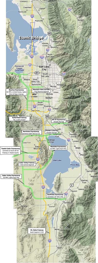
Let me introduce you to Interstate 415, Utah's ultimate infrastructure boost! Complete with a sister network of higher-speed at grade expressways.


If Utah got the money and started building this tomorrow, both Urbanboy and I would probably die of heart attacks.

But for totally different reasons.
Basically, once Legacy N. is built, it will still be funneling traffic through the current bottleneck in Farmington. There's only about a mile of useable land between the lake and the mountains and there are already two parallel freeways and a rail-line there. The area can't really support any additional transportation infrastructure:


So here's my question. Other than pie-in-the-sky dreams, do you ever think that there would be enough need to justify a bridge across Farmington Bay, or will the existing mass-transit and freeways through Davis Co. be able to handle future needs?

A bridge would make a nice connection between the N. end of MVC and Legacy N. in Syracuse, but it would likely cost a fortune and have environmental impacts:

(Chosen MVC and Legacy alignments are in green, bridge is blue.)
Reply With Quote
     
     
  #1787  
Old Posted Jun 25, 2009, 10:10 PM
SLCforme SLCforme is offline
Registered User
 
Join Date: Feb 2007
Location: Salt Lake City
Posts: 403
I personally think the environmental impacts and cost would be too high to justify a bridge... while we're at it I'd rather not see Legacy North happen at all, unless it really were to create a barrier so that ALL the land west of it were preserved as open space wetlands. The current legacy nature preserve is great, but it doesn't encompass all the land west of the parkway, and I would feel much happier about the parkway if it did. As is there is still land that can be developed.
__________________
"Orthodoxy means not thinking-not needing to think. Orthodoxy is unconsciousness."
George Orwell, "1984"
Reply With Quote
     
     
  #1788  
Old Posted Jun 25, 2009, 10:35 PM
arkhitektor arkhitektor is offline
Registered User
 
Join Date: Feb 2005
Location: Clearfield, UT
Posts: 1,784
I'm not saying this smugly, but what would the environmental impacts of such a bridge or causeway actually be?

It seems like the lake is already cut up with causeways, railroad bridges, reservoirs and holding ponds, and that other than the shores and wetlands, supports almost no life at all.

Just wondering? Does anybody smarter than me know? I mean the thing is like 7 different-colored lakes when you look at it from space because its already so chopped up:

Reply With Quote
     
     
  #1789  
Old Posted Jun 26, 2009, 12:40 AM
John Martin's Avatar
John Martin John Martin is offline
Registered User
 
Join Date: Jan 2009
Posts: 1,195
I-stinky.
Reply With Quote
     
     
  #1790  
Old Posted Jun 26, 2009, 5:20 AM
WeST's Avatar
WeST WeST is offline
Registered User
 
Join Date: Apr 2008
Location: Murray
Posts: 340
Quote:
Originally Posted by arkhitektor View Post
I'm not saying this smugly, but what would the environmental impacts of such a bridge or causeway actually be?

It seems like the lake is already cut up with causeways, railroad bridges, reservoirs and holding ponds, and that other than the shores and wetlands, supports almost no life at all.

Just wondering? Does anybody smarter than me know? I mean the thing is like 7 different-colored lakes when you look at it from space because its already so chopped up:


I think the only major problem that could arise would be possible disruption of the migratory birds and their stay at the GSL. Although this could be mitigated through some of the same techniques used on legacy. As long as we are talking about crazy ideas, I think diking the lake at either Farmington Bay or just south of it. This could create a great recreational environment in
Salt Lake proper.
Reply With Quote
     
     
  #1791  
Old Posted Jun 26, 2009, 5:41 AM
John Martin's Avatar
John Martin John Martin is offline
Registered User
 
Join Date: Jan 2009
Posts: 1,195


That idea has been tossed around a lot. The last time I heard it from a public official, it was immediately shot down because of all the sewage that is pumped into the Jordan River.
Reply With Quote
     
     
  #1792  
Old Posted Jun 26, 2009, 3:49 PM
shakman's Avatar
shakman shakman is offline
Chairman
 
Join Date: Jun 2002
Location: PRMD - People's Republic of Maryland
Posts: 2,687
Will this portion of Legacy Parkway be numbered as "I-415"?
__________________
"I measure the value of life not by how much I have, instead by what I have done.

-sb
Reply With Quote
     
     
  #1793  
Old Posted Jun 26, 2009, 7:56 PM
DENrising's Avatar
DENrising DENrising is offline
New Coloradan
 
Join Date: Mar 2008
Location: Denver
Posts: 167
I think 415 was described as a wishlist by another poster, there really are no plans for an I-415 by the Interstate numbering system. Originally 415 was part of the SLC existing beltway (215) but was renamed to 215 for consistency reasons.

Do a search on I-215 in wikipedia for the exact wording.
__________________
New to Colorado
Formerly SLCrising
Reply With Quote
     
     
  #1794  
Old Posted Jun 26, 2009, 8:29 PM
SLCforme SLCforme is offline
Registered User
 
Join Date: Feb 2007
Location: Salt Lake City
Posts: 403
The environmental impacts of a bridge are fairly minor, after the initial construction is done; fluids leaking out of cars and off the road, local concentrations of CO2, noise, birds hit by cars, that sort of thing. A causeway on the other hand completely screws the aquatic ecosystem. The main concern in the case of the great salt lake, since it doesn't have any fish, is the change in salinity in the different parts of the lake, as is the case between the north and south now (poor little brine shrimp). And it's true that there are so many dikes and such around for numerous things, such as industry (the harvest of salt and other minerals from the lake), that the ecosystem has already been quite altered. Then you have work done to create more wetlands around where the Bear River enters, dikes and large freshwater ponds now exist there; and Willard Bay which is also fresh water. Some of these things are good IMHO, as they create more fresh water surface area and habitat for fish and thus the birds that feed off on the fish.
Not sure whether or not I would support another dike creating a freshwater lake in SLCs northwest quadrant or not. There is valuable wetlands there, but then there is also large salt flats as well. Another good thing about building dikes is that it helps to mitigate the impacts of flooding. In 84 the Bear River Migratory Bird Refuge was completely flooded and most of the habitat for migratory birds was destroyed, which actually caused a pretty big decline in the numbers of birds there for a few years, and dikes can help so that won't happen again, if done right of course.
__________________
"Orthodoxy means not thinking-not needing to think. Orthodoxy is unconsciousness."
George Orwell, "1984"
Reply With Quote
     
     
  #1795  
Old Posted Jun 29, 2009, 10:27 PM
urbanboy urbanboy is offline
BANNED
 
Join Date: Feb 2007
Location: Downtown Salt Lake City
Posts: 2,120
The environmental impacts of such a bridge would be tremendous. Not only would the bridge dramatically effect the immediate environment, but also would facilitate unsustainable growth patterns throughout the region. Not to sound smug, but it seems as though many of you would like to cover the earth with roads. The smaller the foot-print of a city, the more manageable and dense it becomes. That means more skyscrapers, and greater access to the great outdoors.
Reply With Quote
     
     
  #1796  
Old Posted Jul 2, 2009, 8:40 PM
arkhitektor arkhitektor is offline
Registered User
 
Join Date: Feb 2005
Location: Clearfield, UT
Posts: 1,784
Quote:
Originally Posted by cololi View Post
As far as ridership goes, Sandy (general area) produces the most downtown riders. They also are expected to produce the most airport users. They also have almost as many riders that go to the University as any other line, WVC is first, but not by much. You obviously cannot have the Sandy line go to all three destinations, but you can get it to hit two: downtown and airport. I think the reason behind teh sandy line stopping at Arena is to prepare it for interlining it with the airport line, so the Blue line (Sandy line) hits downtown and the airport. From an operational stand point, I see the logic in this. But I still don't like the North Temple frontrunner station because it really does take away a great deal of traffic from Central Station.
So, from the information that cololi posted a few pages back, it seems that the W. Jordan line will become the green line and will run to the University, and the blue line would skip SL Central and go to the airport.

Does anybody know what UTA's plans are for the W. Valley (Yellow) line? Will it just end at the 2100 S. Station and riders will transfer there to the green or blue lines?


I'd like to see it continue up the main line from 2100 S., then turn west at 400 S./Main St. and loop to Central Station bypassing downtown, then continue up 600 W. to N. Temple, turn west and continue to the airport. This would allow people to get between downtown and the airport on the blue line with no transfer, and also allow people to travel between the airport and SL Central with no transfers. It would also create track that could be used for a loop to circulate around downtown:


But I doubt that at grade tracks could handle 3 lines in a single alignment downtown, especially the intersection of 400 South / Main street, which would have 5 lines passing through it under this scheme.

Last edited by arkhitektor; Jul 2, 2009 at 10:09 PM.
Reply With Quote
     
     
  #1797  
Old Posted Jul 2, 2009, 10:10 PM
urbanboy urbanboy is offline
BANNED
 
Join Date: Feb 2007
Location: Downtown Salt Lake City
Posts: 2,120
Beautiful! I like it a lot!

Although, can a TRAX route handle more than three TRAX lines?
Reply With Quote
     
     
  #1798  
Old Posted Jul 2, 2009, 10:27 PM
arkhitektor arkhitektor is offline
Registered User
 
Join Date: Feb 2005
Location: Clearfield, UT
Posts: 1,784
Quote:
Originally Posted by urbanboy View Post
Beautiful! I like it a lot!

Although, can a TRAX route handle more than three TRAX lines?
Yeah, like I said above, I'm not sure whether 3 lines can run in a single alignment and the intersection of 4th S. and Main is almost certainly impossible. With five lines running through at 15 min. intervals, they would all have to be perfectly timed and run exactly on schedule for one pass through the intersection every three minutes.

If you eliminated the orange loop line, there would only be a small segment of the N/S line between the Central Pointe and Courthouse stations that would be used by three lines, and since it would all be out of the downtown core, it may be possible.
Reply With Quote
     
     
  #1799  
Old Posted Jul 3, 2009, 4:36 AM
ski_steve ski_steve is offline
Registered User
 
Join Date: Oct 2007
Location: Chicago
Posts: 467
I think they are planning on having every Trax train originate from the Intermodal hub, then disperse along their separate lines. It remember something like there will be a train every 3-5 mins though downtown.

I completely agree that we need some kind of connector. I think UTA is considering it, but nothing is in the works until the new lines are completed.
Reply With Quote
     
     
  #1800  
Old Posted Jul 3, 2009, 3:32 PM
cololi cololi is offline
Registered User
 
Join Date: Jul 2008
Posts: 690

The Blue Line (Sandy) will not go to Central Station. It will stop at Arena. This change happens in August I think. Jordan and the U will go to the hub for now. No final word on the other lines under construction.

Not all lines can go through downtown because intersections begin to fail. As much as people hate cars, it is integral for commerce that people be able to move around downtown in cars.
Reply With Quote
     
     
This discussion thread continues

Use the page links to the lower-right to go to the next page for additional posts
 
 
Reply

Go Back   SkyscraperPage Forum > Regional Sections > United States > Mountain West
Forum Jump


Forum Jump


All times are GMT. The time now is 4:13 AM.

     
SkyscraperPage.com - Privacy Statement - Top

Powered by vBulletin® Version 3.8.7
Copyright ©2000 - 2026, vBulletin Solutions, Inc.