In my two prior LMI posts:
http://forum.skyscraperpage.com/show...ostcount=16204
http://forum.skyscraperpage.com/show...ostcount=16219
I showed that the location of the Lookout Mountain Inn was at (what is now) 2355 Sunset Plaza Drive.
3940dxer and I decided we should scale Wulff's Peak (now a nameless bump with radio antennas and water tanks at the convergence of Walker Drive, Ridgemont Drive, and Crescent Drive) to see if we could recreate the distant view of the Inn he had discovered.
The Lookout Mountain Park Land and Water Company sold the parcel containing Wulff's Peak to E.L. Doheny in 1913:

At
http://skyscraperpage.com/forum/show...ostcount=15754 I described finding the Wulff's Peak deed at the Assessor's Office in Norwalk. I then traced the parcel description on top of a current topographic map to see where the peak is today. The "Belvedere of America," as the article calls it, is indeed the high point between Laurel and Coldwater Canyons.
Getting the "Now" half of the "Now and Then" was easier said than done. After rejecting Walker Drive and Crescent Drive as starting points due to high fences, we drove to Ridgemont Drive. There, the public street ended in a gate made of pointy spikes. We could see the street continuing up the grade, with houses beyond. After getting out of our car, we stood around for a while wondering what to do. Climbing over the gate was possible, but we could hear people in the houses beyond. Maybe they were "stand your ground" enthusiasts?
Just as we were about to give up, a car drove up. The driver punched the entry code into the control box, and the gate slowly swung open. She drove through and on up the hill out of sight. 3940dxer and I looked at each other speculatively. At the last possible moment, we darted through the gate as it clanged shut. Trying to look unobtrusive (difficult owing to the camera equipment), we nonchalantly walked on and up, hoping not to encounter anyone. We did meet the driver as she was entering her house. We explained to her what we were doing and fortunately she waved us on.
The road ends below the summit, and we scrambled as far up as we could (not recommended in street shoes) to take our pictures. And of course not having the gate code, we ended up having to climb the fence on the way out without impaling ourselves. This was tricky.
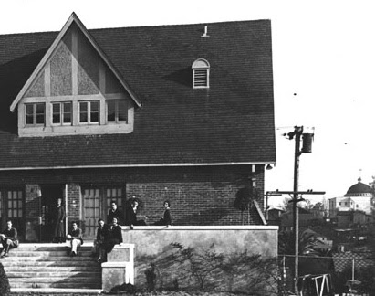
Here is a "then and now" pair from the same point 100 years apart. The perspective is slightly different because the "then" picture was taken with a wide-angle, short focal length lens making it appear to have been taken from a greater distance.
c. 1913

16 August 2013

In the modern view, from left to right, we have:
- the ridge of “Cyprean Hill” (water tank and antennae)
- Cyprean Drive,
- the brown Tudor house perched just above Appian Way at 2020 Cyprean Drive, on southwestern-most knoll of Cyprean Hill,
- trees masking the sight line right down the middle of Appian Way
- the height of land marked 1453 feet in the old topo, now 2460 Sunset Plaza Drive
- the 2355 Sunset Plaza Drive house (site of the Inn, and later the Lew Ayres house), and
- the 2300 Sunset Plaza Drive house at the right edge of the screen.
- Crescent Drive leading off to the “Double Bow Knot” curves beyond the frame to the left.
It is striking how much vegetation has been introduced in 100 years. Is it possible that the two bumps on the ridge line of Cyprean Hill visible above the second “2” are the same as the mature trees seen just above the second “2” in the modern picture? Also note the slope of the scar of the road leading down at 4 o’clock from the inn (today’s upper Sunset Plaza leading down to the intersection with upper Crescent Drive, it is identical in both pictures. Both photos agree with the 1926 topo map, which shows Crescent Drive contours just below the ridge line from the Double Bow Knot area to the intersection with upper Sunset Plaza.
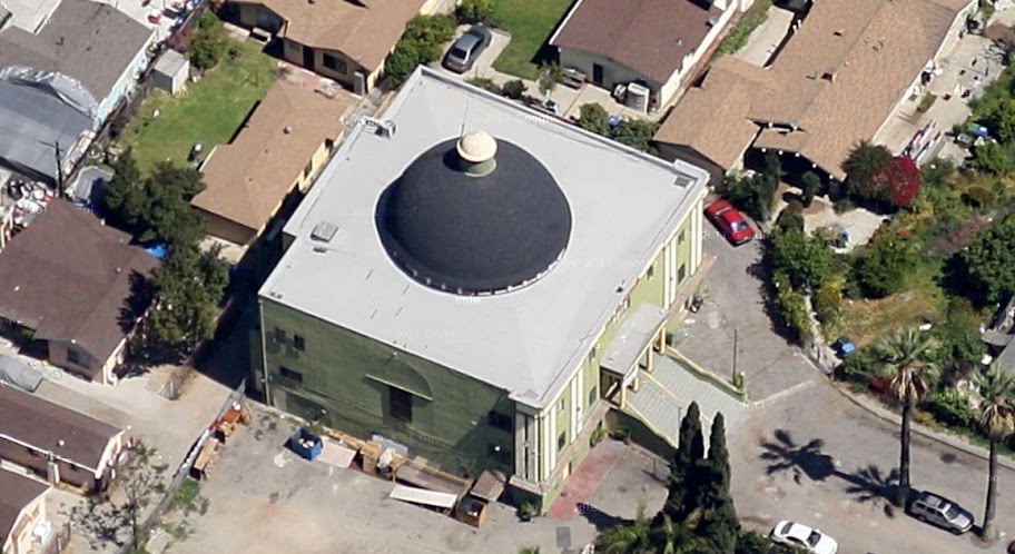
The Bandstand was built on top of Lookout Mountain, the conical hill shown at #4. The 1926 topo shows the hill as about 50 feet higher than the saddle at the intersection of Appian Way and Barcelona. This now is the hairpin turn on Appian Way, and has been leveled since, most recently in 2001 when the owner of 8782 sold the parcels inside the hairpin to a developer. As a result, our neighborhood was gifted with the spec houses at 8787, 8777, and 8765.
Big thanks to 3940dxer for his interest and help.


 Prev
Prev


 Correct change only? Personal checks?


 Nice.
Nice.


 Google


 Linear Mode
