HomeDiagramsDatabaseMapsForum About
     

Go Back   SkyscraperPage Forum > Regional Sections > Canada > Alberta & British Columbia > Vancouver > Transportation & Infrastructure


Reply

 
Thread Tools Display Modes
     
     
  #1421  
Old Posted Dec 24, 2015, 9:34 AM
Stingray2004's Avatar
Stingray2004 Stingray2004 is offline
Registered User
 
Join Date: Jan 2004
Location: White Rock, BC (Metro Vancouver)
Posts: 3,145
Quote:
Originally Posted by aberdeen5698 View Post
It wasn't designed to fit in with a specific freeway plan, it was designed so that it could connect to a freeway that might be planned in the future. The 1950's was an era where it was pretty much assumed that there would be freeways into downtown sooner or later, so the "forward thinking" of the time was "let's make sure it can accommodate a freeway".
So ya are saying that Granville St. in the downtown core as well as Granville St. on the south shore would have been demolished to make way for a new freeway back circa 1950 when the GSB was first proposed and designed? Because that would have been the only corridor.

The term or concept - freeway - was not even in the lexicon in this neck of the woods back (or backwater) then. Not even really in the U.S. back then either - the trailblazers in this category.

Again, I prepared a paper, back in my UBC days, on all Van City freeway proposals - reviewed all engineering reports from UBC Special Collections, etc. - there never was any assumption back then. Period. That concept was NEVER on the radar screen.

Using your analogy, the new Cambie Street Bridge was also part of a larger freeway plan when it was completed, circa 1986, under then Mayor Mike Harcourt. The Cambie Street Bridge certainly has much better design standards for a freeway connection than the GSB ever had. Yep.
Reply With Quote
     
     
  #1422  
Old Posted Dec 24, 2015, 9:48 AM
VancouverOfTheFuture's Avatar
VancouverOfTheFuture VancouverOfTheFuture is offline
Registered User
 
Join Date: Apr 2014
Posts: 3,481
Quote:
Originally Posted by Pinion View Post
Why was a third Burrard Inlet crossing considered many decades ago but now it's considered impossible?
i wondered that myself as well. i must say a 3rd crossing is the best idea. and a tunnel would be nice. i always like the 1972 proposal the best myself. it created a ton of green park space/addition to Stanley Park and it was very good looking.

http://forum.skyscraperpage.com/showpost.php?p=5556972&postcount=1421

though i cant wait for the new 10 lane bridge. the tunnel was always annoying. no radio reception in it. and sometimes you can be stuck under there for awhile in traffic.
Reply With Quote
     
     
  #1423  
Old Posted Dec 24, 2015, 3:08 PM
Rico Rico is offline
Registered User
 
Join Date: Feb 2012
Posts: 319
Quote:
Originally Posted by Stingray2004 View Post
I`m quite confident that your opinion was also the prevailing attitude, back in the day, involving these crossing projects, for example:

1. 8-lane Granville Street Bridge replaces 2 or 4 lane previous structure, which included major streetcar network, back in 1954, when it was completed. 8 lanes? What were these guys thinkin`? 4 lanes woulda been good enough. No? An era when the West End was still mostly single family dwellings and suburbs were basically non-existent for all intent and purposes. Well guess what? Kudos to the then city and esp. the civil engineers for that excellent design inclusive of incorporation of street networks on either side. Will continue to be a major crossing, well into the future, without any need for replacement. Great taxpayer value there. Seismic upgrades already in place.

2. 6-lane IWMB 2nd crossing replaces 1 or 2 lane crossing, which included CN rail line, back in 1960. 6 lanes? What were these guys thinkin? 4 or 2 lanes would have been good enough. No? An era when the Horseshoe Bay Ferry Terminal didn`t yet exist (with initial planning), northward from there was the boonies, and North Van & West Van itself were still a good chunk of wilderness. Well guess what? Thankfully that 6-lanes were initially constructed. Otherwise, a replacement would have been required long ago. Even then, it will eventually need to be replaced by another 10-lane structure akin to the PMB and GMB.

3. 4-lane Massey Tunnel replaces ferry crossing back in 1959. 4-lanes? What were these guys thinkin? 2 lanes would have been good enough. No? An era when Richmond was farmland and everything south of there was desolate. Hell, residential,development continued, south of 41st Ave. in Van City, until the mid-1960`s along the Oak St. corridor. Even the BC political opposition called the then GMT a `Tunnel To No Where`. And that, in itself, likely was an impetus to decrease the initial 6-lane design to a 4-lane design. Unfortunately, a 6-lane design, back in the day, would have been better value for the taxpayer in hindsight.

4. 4-lane Knight Street Bridge replaces 2-lane Fraser St. Bridge back in 1974. Plenty of lanes back in the day. No? Well guess what - just 20+ years later, in the 1990`s, a plan was afoot to expand same to 6-lanes based upon the document download on the GMT replacement project website. Would have been a helluva lot more economical to have had an initial 6-lane Knight Street Bridge in the first place based upon today`s traffic volumes. No?

I can go on and on. But I hope ya get my drift.

And another 1 million are expected in the Metro Vancouver region within the next 30 - 40 years. Do not need to be a rocket scientist to figure that one out in terms of future bridge demand in terms of capacity.
The first thing I would like to point out is over built infrastructure costs money. Your first example the Granville bridge has never used all of its capacity. How much money adjusted to inflation would 2 fewer lanes have saved? You make some valid points about the other projects....with an important catch. Those were all 'FREE' bridges and demand was not regulated by tolls. People are not rational about tolls, they will avoid them even when it is in their best interest to use the tolled option. Tolls can be a great demand regulator and will be for the GMT. The next point is specific to the GMT, where is the new demand coming from? Ladner? Tsawassen? Obviously there is not a lot of potential growth there unless we open up the ALR. That leaves South Surrey and North Delta, potential growth there...but...what the GMT will do is make better options less attractive. Why not build the Patulla replacement, King George LRT, AFB improvements, they compete for the same population growth and they cost everyone less. Here is my dirty secret, I don't mind a little rush hour congestion, it just should not be too bad, if the GMT project was free a 7 or 8 lane option would have congestion on day one in the rush hour direction. Of course with a Free 10 lane GMT option there will be congestion too, just not at the tunnel, it will be longer congestion at Oak street....so next we have to build another crossing....more money. A 7 or 8 lane option will cost less and get you free flowing counter flow traffic.....and I am guessing not much difference for 1/2 the people (10 lanes will be better for people heading to Richmond in the morning or leaving Richmond in the evening) the question is, is it worth the cost? How much would you pay to avoid some congestion? Picture that number then ask yourself would you pay that as a toll? If the 7 or 8 lane option has too much congestion raise the toll, problem solved at much less cost to society.
Reply With Quote
     
     
  #1424  
Old Posted Dec 24, 2015, 4:38 PM
aberdeen5698's Avatar
aberdeen5698 aberdeen5698 is offline
Registered User
 
Join Date: May 2010
Posts: 4,776
Quote:
Originally Posted by Stingray2004 View Post
So ya are saying that Granville St. in the downtown core as well as Granville St. on the south shore would have been demolished to make way for a new freeway back circa 1950 when the GSB was first proposed and designed? Because that would have been the only corridor.
Again, I'm not saying that there was a specific plan for Granville street in the 50's, but people were certainly thinking about these kinds of projects, and so the infrastructure designers would have been foolish not to consider those possibilities at the time.

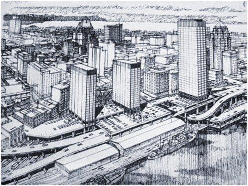
The waterfront freeway proposal got its start in 1954:


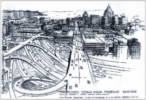
And the 1960's downtown freeway proposal shows that some people had no qualms whatsoever about razing entire sections of the city to accommodate cars.


This was the era when Robert Moses was hailed as a visionary.

(images from Raise the Hammer)
Reply With Quote
     
     
  #1425  
Old Posted Dec 24, 2015, 6:08 PM
Stingray2004's Avatar
Stingray2004 Stingray2004 is offline
Registered User
 
Join Date: Jan 2004
Location: White Rock, BC (Metro Vancouver)
Posts: 3,145
Quote:
Originally Posted by Rico View Post
You make some valid points about the other projects....with an important catch. Those were all 'FREE' bridges and demand was not regulated by tolls. People are not rational about tolls, they will avoid them even when it is in their best interest to use the tolled option.
Interestingly enough, these crossings were all tolled from Day 1:

1. GMT;
2. Oak Street Bridge;
3. Lions Gate Bridge;
4. IWM 2nd Narrows Bridge;
5. Queensborough bridge;
6. Pattullo Bridge;

BTW, when the GMT opened back in 1959, one was required to pay a 25 cent toll on both the OSB as well as the GMB. Adjusted for inflation, using the inflation calculator from the Bank of Canada, that would be an equivalent $4.10 in 2015 using the combo in one direction.

All tolls were lifted on April 1 (April Fools Day), 1964.


Quote:
Originally Posted by Rico View Post
The next point is specific to the GMT, where is the new demand coming from? Ladner? Tsawassen? Obviously there is not a lot of potential growth there unless we open up the ALR. That leaves South Surrey and North Delta, potential growth there...but...what the GMT will do is make better options less attractive. Why not build the Patulla replacement, King George LRT, AFB improvements, they compete for the same population growth and they cost everyone less.
Firstly, the Pattullo Bridge replacement will completed as well. No doubt about that. That said, it serves a completely different catchment area. And north Surrey LRT will also be completed. Again, a different catchment area and will essentially supplant many current buses. OTOH, no improvements can be done to the AFB.

As for future potential demand for the GMB, some nodes:

1. U.S. border traffic;
2. IIRC, just one area in South Surrey is expected to see an increase of around 140,000 over the next couple of decades;
3. Ferry traffic - population will continue to grow on southern Van Isle, over the decades, which will fuel additional demand thereto IMHO;
4. Roberts Bank superport - normal growth as well the container terminal expansion, etc. fuel additional container truck traffic;
5. Many (including myself) avoid the GMT at many times of the day by using the longer AFB & Hwy 91 combo. I would not be surprised if that costs me another $1 or more in gasoline costs as a result. Would def revert back to the shorter length new GMB;

When infrastructure is built, I prefer to see same built for at least the 40-year time horizon. Just makes sense to me. In that vein, I would also prefer a lower $1.50 - $2 toll - in that vein the Van Suns Vaughn Palmer wrote an interesting piece a few years back:

http://www.vancouversun.com/Vaughn+Palme...+cash/9073794/story.html?__lsa=3404-af52

Reply With Quote
     
     
  #1426  
Old Posted Dec 24, 2015, 7:12 PM
SFUVancouver's Avatar
SFUVancouver SFUVancouver is online now
Registered User
 
Join Date: Dec 2006
Location: Hamilton
Posts: 6,661
It's worth recalling that the majority of bridges in the region were once tolled:

Lions Gate Bridge (tolled from opening in 1939 until 1963)
Iron Workers Memorial Bridge (tolled from opening in 1960 until 1963) Bonus photo
Oak Street Bridge (tolled from opening in 1957 until 1959)
Queensborough Bridge (tolled from opening in 1960 until 1966)
George Massey Tunnel (tolled from opening in 1959 until 1964)
Pattullo Bridge (tolled from opening in 1937 to 1952) Bonus photo

With that said, these were not demand management tolls, but rather cost-recovery tolls and they consistently failed to recover sufficient revenue to service their debt. In a populist move, the Socreds removed the tolls on all Provincial bridges and the for the Queensborough Bridge the City of New Westminster removed the tolls once they took ownership of the bridge. Incidentally, demand management and cost recovery are two very different goals.
__________________
VANCOUVER | Beautiful, Multicultural | Canada's Pacific Metropolis

Last edited by SFUVancouver; Dec 24, 2015 at 10:43 PM.
Reply With Quote
     
     
  #1427  
Old Posted Dec 24, 2015, 8:11 PM
POCO POCO is offline
Registered User
 
Join Date: Nov 2015
Posts: 85
Quote:
Originally Posted by SFUVancouver View Post
It's worth recalling that the majority of bridges in the region were once tolled:

Lions Gate Bridge (tolled from opening in 1939 until 1963)
Iron Workers Memorial Bridge (tolled from opening in 1960 until 1963) Bonus photo
Oak Street Bridge (tolled from opening in 1957 until 1959)
Queensborough Bridge (tolled from opening in 1960 until 1966)
George Massey Tunnel (tolled from opening in 1959 until 1964)
Pattullo Bridge (tolled from opening in 1937 to 1952) Bonus photo

With that said, these were not demand management tolls, but rather cost-recovery tolls. Demand management and cost recovery are two very different goals.
Wow. The Iron Workers bridge looks stunning in that photo.
Reply With Quote
     
     
  #1428  
Old Posted Dec 24, 2015, 11:04 PM
trofirhen trofirhen is offline
Registered User
 
Join Date: Oct 2008
Posts: 9,043
Quote:
Originally Posted by Pinion View Post
Why was a third Burrard Inlet crossing considered many decades ago but now it's considered impossible?
That is somethiong I would like to know.
I think it would be Cost$$$$$ and the necessary infrastructure rebuild.
There might be "aesthertic" reasons, too, but a crossing with space for transit in the middle, but I'd love a geat dispersal system for the N Shore,
and a dispersal system downtown, ... and an underground crosstown link through Vancouver.
If it were done right, it would be a boon to the city, IMO, although I'd probably get lapidated for saying so.
Reply With Quote
     
     
  #1429  
Old Posted Dec 25, 2015, 1:00 AM
officedweller officedweller is offline
Registered User
 
Join Date: Jul 2001
Location: Vancouver
Posts: 41,500
Quote:
Originally Posted by SFUVancouver View Post
It's worth recalling that the majority of bridges in the region were once tolled:
and the predecessor to the Patullo - the New Westminster rail bridge (which had an upper car deck) was also tolled - it even tolled pedestrians crossing it.

Quote:
And regarding the tolls on the Westminster Bridge (now rail only):

Bridge liberated: Fraser River tolls removed
https://oppositethecity.wordpress.com/2014/11/03/bridge-liberated-fraser-river-tolls-removed/

Quote:
The toll was-
Pedestrians 5 cents
Horses & rig 10 cents
Loaded drays & wagons 20 cents
https://oppositethecity.wordpress.com/2014/11/03/bridge-liberated-fraser-river-tolls-removed/
Also for future bridge traffic, trucks carrying dangerous cgoods will now be permitted.
i.e. this regulation will cease to apply:

http://www.bclaws.ca/civix/document/id/complete/statreg/275_2006
Reply With Quote
     
     
  #1430  
Old Posted Dec 25, 2015, 1:54 AM
Stingray2004's Avatar
Stingray2004 Stingray2004 is offline
Registered User
 
Join Date: Jan 2004
Location: White Rock, BC (Metro Vancouver)
Posts: 3,145
Quote:
Originally Posted by officedweller View Post
and the predecessor to the Patullo - the New Westminster rail bridge (which had an upper car deck) was also tolled - it even tolled pedestrians crossing it.
Even more bridge structures were tolled from that era:

1. Sea Island Bridge;
2. Agassiz Bridge;
3. Kelowna Floating Bridge;
4. Nelson Bridge;
5. Even the old Fraser Canyon Highway back in the 1930s and 1940s;

Again, that specific era ended at 7 pm on April 1, 1964 when then Dept. of Highways minister Phil Gaglardi as well as former MLA George Massey were the last vehicle thru the Oak Street Bridge toll station as well as the GMT toll station.

http://www.th.gov.bc.ca/publications/roadrunners/1964/1964_06_june.pdf

Merry Christmas!
Reply With Quote
     
     
  #1431  
Old Posted Dec 28, 2015, 5:57 AM
ssiguy ssiguy is offline
Registered User
 
Join Date: Mar 2006
Location: White Rock BC
Posts: 11,902
I hate this idea that Vancouver is "liveable" because it doesn't have a freeway and hence having one would make it "unliveable". What a childish and parochial attitude which is probably why Price and company always espouse it.

Vancouver's problems started when it cancelled it's freeway program of the early 1960s.
The problem was not cancelling the freeways as much as it was just cancelling the conversation. Vancouver decided it didn't want freeways tearing up neighbourhoods {which I agree with} but their alternative was to simply do nothing.

Remember Vancouver not only didn't build freeways, it also didn't build transit nor even save potential corridors for it's possibilities. Vancouver was the last of Canada's 6 big cities to get any rapid transit. By the time they did it, much ended up going thru lower density areas. When they finally got serious about rapid transit they continued their tried and true habit of building them with little vision for the future in mind.

I don't think there is a transit system on the planet that builds stations less than 100 meters little alone the Canada Line Tonka Toy stations which are both ridiculously small and downright dangerous.

Vancouver has made a lot of very forward thinking planning decisions which has resulted in it's high quality of life. Transportation planning, however, has been a complete failure of monumental proportions. For a city of just 2.5 million surrounded by no other major cities to have the 2nd longest commutes in NA is ridiculous and is a result of pitiful transportation planning.

Due to the region not setting aside any corridors for future roadways or even transit lines, it will only get much worse. Vancouver's traffic and commuting woes have nothing to do with it's geography and everything to do with shockingly poor planning. The "water and mountains make it hard" is a very convenient excuse but it is exactly that, an excuse for a transportation planning dept with no vision, touchy-feely left-wing activists with no grip on reality, and politicians of no backbone.
Reply With Quote
     
     
  #1432  
Old Posted Dec 28, 2015, 4:09 PM
moosejaw moosejaw is offline
Registered User
 
Join Date: Apr 2012
Location: Miami
Posts: 482
I can understand the rationale for not building freeways throughout Vancouver.
Why continue to build your way out of congestion when studies shows you will never keep up with traffic volume?

The city is unique in the fact that its very dense, in fact so dense it trumps most American Cities with the exception of the borough of Manhattan and San Francisco. Within the city limits i think the city has done a somewhat decent job of managing its infrastructure with its own resources. Lets face it tearing down houses to build a true grade separated artery is not going to happen. In order to move the most amount of people efficiently throughout Vancouver is via transit ie Skytrain or even dedicated bus roads. Even if you did have one freeway leaving downtown and coming to the OSB or Cassiar Connector, lets face it you will still have those who will use surface streets to bypass the traffic mess as its common in many US cities. Discouraging a use of private car is a must for the COV. I think Canadian commuting preferences are similar to american commuting preferences, in that we both like the comfort of our car. The city needs to start looking at congestion charges to enter downtown and even to enter the city limits. Build transit hubs where HWY 1, 99 and 91 end. Use commuter trains like the WCE and start studying how cities in Japan and Europe move people around.

Where I think the system fails is in the suburbs.
The three major highways in the lower mainland don't even come close to any urban population centers.
Hwy 1 bisects Deer Lake Park
Hwy 99 and 91 cuts through ALR lands or rural areas.
Whose idea was it anyways to designate farmland for protection so close to an urban center? Did planners and engineers have any dialogue with anybody else when Vancouver invited the world for Expo 86? When Vancouver began in urban densification program in the early 90s, did it have any clue where it would be headed?

In most cities they build arteries close to urban centers, yet in the lower mainland they build them in the strangest areas that really don't serve the population center. If you were to drive up from the US border or from out east on the 401 you really don't know you're in Vancouver until you are at the city limits? The environmentalists love to point out that cities have all embraced freeway removal (Seoul, Dallas, San Francisco, and Hamburg) and livable space. The difference is all of those cities still have freeways to move goods and people around. Look at 1nterstate 5 in Seattle as it approaches city limits (disregard its a mess with its size and express lanes for one second). Interstate 5 is trenched in the middle of communities. Not farm land, not industrial centers. There are shopping malls, gas stations, and restaurants that supplement that road. That doesnt exist in BC.

We can all agree that any improvement with road infrastructure within the city will not happen especially with the stats flying out there that less and less vehicular traffic is entering the downtown core year after year. (secretly i would love to see a big dig type project happen around the viaducts/downtown core)

However I am happy to see Highway 99 is finally getting updated although i do agree with the consensus that the bottleneck will eventually move to the OSB.

Finally come on man that Tom Tom study is flawed, who uses a tom tom anyways? I cant even give my old one away on Craigslist.
Reply With Quote
     
     
  #1433  
Old Posted Dec 28, 2015, 5:33 PM
WarrenC12's Avatar
WarrenC12 WarrenC12 is online now
Registered User
 
Join Date: May 2007
Location: East OV!
Posts: 24,555
I actually find driving around city centres SOF, particularly fast growing ones like Surrey and Langley, to be worse than downtown Vancouver. Langley is like a gridlock around Willowbrook most days.
Reply With Quote
     
     
  #1434  
Old Posted Dec 28, 2015, 7:46 PM
GMasterAres GMasterAres is offline
Registered User
 
Join Date: Oct 2007
Location: Hamburg
Posts: 3,116
Quote:
Originally Posted by officedweller View Post
Probably not to the extent it was actually designed, but it was studied and proposed.

This page cites a 1964 freeway plan/study that has an east-west freeway:
Granville Street Bridge was completed in 1954 and started construction in 1951, 13 years before this proposed freeway plan/study was taken place.

The freeway plan was a result of the Granville Street Bridge, not the other way around. Chicken before egg here unfortunately. I'm sure though when they designed the Granville Street Bridge in the late 40s the idea of a potential future freeway network was in mind. It just makes sense. Just like today the government always jumps up and says "Bridge can accommodate rapid transit in the future!!!"

Doesn't mean it is for that purpose.
Reply With Quote
     
     
  #1435  
Old Posted Dec 28, 2015, 7:53 PM
GMasterAres GMasterAres is offline
Registered User
 
Join Date: Oct 2007
Location: Hamburg
Posts: 3,116
Quote:
Originally Posted by WarrenC12 View Post
I actually find driving around city centres SOF, particularly fast growing ones like Surrey and Langley, to be worse than downtown Vancouver. Langley is like a gridlock around Willowbrook most days.
Langley is horrible. 200th especially. You hit every light and every light is far too short. Worst intersection by far is 200th and the Langley Bypass. Only other city I hate driving around in worse than Langley is Coquitlam which I believe purposely times its lights to have every car parked 90% of the time while traversing the city.

Surrey suffers from (1) a lack of major corridors and (2) most major corridors not being wide enough. Fraser Highway through Surrey Central, 100th Ave = 1 lane. Then you have a massive stretch from 88th to 72nd where there are virtually no east-west corridors in-and-around King George.

Also still a lot of dead-end roads and non-connecting roads in Surrey Central and other parts of the city. You end up needing to zig-zag around if you're not on 96th, 100th, 104th or 108th. A "major downtown" only having 4 east-west arteries is a big problem. In that same stretch in Downtown Vancouver you have about 50 similar roads and at least 20 major arteries.

It's difficult to argue with the grid design of Vancouver from a conceptual traffic movement perspective. Vancouver has different problems like a lack of left-turn lanes, allowing parking on major roads, and just excessive pedestrian traffic backing up right/left turners. But the roads themselves from a grid design are very efficient.

And I'd have to agree, driving in downtown Vancouver is actually not bad most of the time. It has its moments, but compared to other downtowns, even Metrotown which can be extremely frustrating, it is pretty darned good.
Reply With Quote
     
     
  #1436  
Old Posted Dec 28, 2015, 7:59 PM
GMasterAres GMasterAres is offline
Registered User
 
Join Date: Oct 2007
Location: Hamburg
Posts: 3,116
Quote:
Originally Posted by ssiguy View Post
I hate this idea that Vancouver is "liveable" because it doesn't have a freeway and hence having one would make it "unliveable". What a childish and parochial attitude which is probably why Price and company always espouse it.

Vancouver's problems started when it cancelled it's freeway program of the early 1960s.
The problem was not cancelling the freeways as much as it was just cancelling the conversation. Vancouver decided it didn't want freeways tearing up neighbourhoods {which I agree with} but their alternative was to simply do nothing.

Remember Vancouver not only didn't build freeways, it also didn't build transit nor even save potential corridors for it's possibilities. Vancouver was the last of Canada's 6 big cities to get any rapid transit. By the time they did it, much ended up going thru lower density areas. When they finally got serious about rapid transit they continued their tried and true habit of building them with little vision for the future in mind.

I don't think there is a transit system on the planet that builds stations less than 100 meters little alone the Canada Line Tonka Toy stations which are both ridiculously small and downright dangerous.

Vancouver has made a lot of very forward thinking planning decisions which has resulted in it's high quality of life. Transportation planning, however, has been a complete failure of monumental proportions. For a city of just 2.5 million surrounded by no other major cities to have the 2nd longest commutes in NA is ridiculous and is a result of pitiful transportation planning.

Due to the region not setting aside any corridors for future roadways or even transit lines, it will only get much worse. Vancouver's traffic and commuting woes have nothing to do with it's geography and everything to do with shockingly poor planning. The "water and mountains make it hard" is a very convenient excuse but it is exactly that, an excuse for a transportation planning dept with no vision, touchy-feely left-wing activists with no grip on reality, and politicians of no backbone.
Yah Melbourne is also quite livable, has recently been #1 ranked, and has a freeway cutting straight through the middle of it and downtown. In addition it has 2 freeways flanking it east and west.

Vienna is also ranked highly livable as with Perth and Zurich. Vienna, like Melbourne, has a freeway straight through the middle along with another flanking the river. Zurich has 3 major freeways connecting to the center directly. Perth has 1 major freeway crossing into it and a 'ring freeway' around it.

So not having a freeway in Vancouver has absolutely no effect on it being livable since other cities are ranked as livable or more livable than Vancouver and have major freeway networks in and around downtown cores and throughout the city.
Reply With Quote
     
     
  #1437  
Old Posted Dec 29, 2015, 12:43 AM
officedweller officedweller is offline
Registered User
 
Join Date: Jul 2001
Location: Vancouver
Posts: 41,500
Quote:
Originally Posted by jhausner View Post
Granville Street Bridge was completed in 1954 and started construction in 1951, 13 years before this proposed freeway plan/study was taken place.

The freeway plan was a result of the Granville Street Bridge, not the other way around. Chicken before egg here unfortunately. I'm sure though when they designed the Granville Street Bridge in the late 40s the idea of a potential future freeway network was in mind. It just makes sense. Just like today the government always jumps up and says "Bridge can accommodate rapid transit in the future!!!"

Doesn't mean it is for that purpose.
The quote from Spacing that I quoted mentioned the 1954 establishment of a Technical Committee for Metropolitan Planning, which produced a 1959 plan that included an Arbutus Freeway. If the issue of freeways was prevalent enough in 1954 for the establishment of a Committee (and you know how slowly government works), then there would have been discussion about freeways for many years before that.

So as you, Stingray2004 and Aberdeen mention, in the 1950s, there would have been a general desire to accommodate future freeways, without there being a specific design or plan.
i.e. as you mention, like future rapid transit over the future Massey Bridge.
Another example would be the City of Vancouver's purchase of the Kettle of Fish building for a vehicle ramp from Burrard Bridge to Hornby St.
Reply With Quote
     
     
  #1438  
Old Posted Dec 29, 2015, 12:44 AM
EastVanMark EastVanMark is offline
Registered User
 
Join Date: Oct 2006
Posts: 1,610
Quote:
Originally Posted by ssiguy View Post
I hate this idea that Vancouver is "liveable" because it doesn't have a freeway and hence having one would make it "unliveable". What a childish and parochial attitude which is probably why Price and company always espouse it.

Vancouver's problems started when it cancelled it's freeway program of the early 1960s.
The problem was not cancelling the freeways as much as it was just cancelling the conversation. Vancouver decided it didn't want freeways tearing up neighbourhoods {which I agree with} but their alternative was to simply do nothing.

Remember Vancouver not only didn't build freeways, it also didn't build transit nor even save potential corridors for it's possibilities. Vancouver was the last of Canada's 6 big cities to get any rapid transit. By the time they did it, much ended up going thru lower density areas. When they finally got serious about rapid transit they continued their tried and true habit of building them with little vision for the future in mind.

I don't think there is a transit system on the planet that builds stations less than 100 meters little alone the Canada Line Tonka Toy stations which are both ridiculously small and downright dangerous.

Vancouver has made a lot of very forward thinking planning decisions which has resulted in it's high quality of life. Transportation planning, however, has been a complete failure of monumental proportions. For a city of just 2.5 million surrounded by no other major cities to have the 2nd longest commutes in NA is ridiculous and is a result of pitiful transportation planning.

Due to the region not setting aside any corridors for future roadways or even transit lines, it will only get much worse. Vancouver's traffic and commuting woes have nothing to do with it's geography and everything to do with shockingly poor planning. The "water and mountains make it hard" is a very convenient excuse but it is exactly that, an excuse for a transportation planning dept with no vision, touchy-feely left-wing activists with no grip on reality, and politicians of no backbone.
A late entry, but definitely in the running for post of the year.

As you astutely point out, other "livable" cities (some even more than Vancouver) have freeways running right through them. Somewhere along the line, the Gordon Price types socially engineered the idea of the lack of freeways in Vancouver was the sole force behind Vancouver's "livability." In reality, ignoring traffic problems, or getting involved in PR bullsh*t of pushing questionable "figures" in order to push a political agenda does nothing to tackle the real world traffic problems both now and in the future, and has done immense damage to the affordability of the region.
Reply With Quote
     
     
  #1439  
Old Posted Dec 29, 2015, 12:47 AM
EastVanMark EastVanMark is offline
Registered User
 
Join Date: Oct 2006
Posts: 1,610
Quote:
Originally Posted by Pinion View Post
Why was a third Burrard Inlet crossing considered many decades ago but now it's considered impossible?
That's easy. Stupid governments on both sides of the water.
Reply With Quote
     
     
  #1440  
Old Posted Dec 29, 2015, 4:28 AM
Pinion Pinion is offline
See ya down under, mates
 
Join Date: Jul 2007
Posts: 5,167
Quote:
Originally Posted by EastVanMark View Post
That's easy. Stupid governments on both sides of the water.
Same government that's building giant bridges all over the burbs.
Reply With Quote
     
     
This discussion thread continues

Use the page links to the lower-right to go to the next page for additional posts
 
 
Reply

Go Back   SkyscraperPage Forum > Regional Sections > Canada > Alberta & British Columbia > Vancouver > Transportation & Infrastructure
Forum Jump


Forum Jump


All times are GMT. The time now is 7:29 PM.

     
SkyscraperPage.com - Privacy Statement - Top

Powered by vBulletin® Version 3.8.7
Copyright ©2000 - 2026, vBulletin Solutions, Inc.