HomeDiagramsDatabaseMapsForum About
     

Go Back   SkyscraperPage Forum > Regional Sections > Canada > Alberta & British Columbia > Vancouver > Transportation & Infrastructure


Reply

 
Thread Tools Display Modes
     
     
  #1121  
Old Posted Mar 11, 2016, 12:00 AM
officedweller officedweller is offline
Registered User
 
Join Date: Jul 2001
Location: Vancouver
Posts: 38,850
If that corner site is built to the sidewalk, a streetcar would have to make a 90 degree corner on a narrow street.
It's really means of giving the streetcar a dedicated right of way.
For example, the streetcar right of way at the Bayshore Gardens project (Cardero & Georgia) cuts the corner quite a bit.

Original map from Bing.


http://www.bing.com/mapspreview?q=va...en&FORM=HDRSC4


http://vancouver.ca/files/cov/downto...n-section4.pdf

Last edited by officedweller; Mar 11, 2016 at 12:22 AM.
Reply With Quote
     
     
  #1122  
Old Posted Mar 11, 2016, 12:58 AM
whatnext whatnext is offline
Registered User
 
Join Date: Feb 2009
Location: Vancouver
Posts: 23,235
Neat map, thnks for sharing that. It would be great to see such an extensive streetcar system. Even better would be to extend it along Whyte Ave to Kits Beach, if for nothing else than to see the Kits Points residents' heads explode!
Reply With Quote
     
     
  #1123  
Old Posted Mar 11, 2016, 1:37 AM
swimmer_spe swimmer_spe is offline
BANNED
 
Join Date: Apr 2014
Posts: 10,738
If Vancouver wanted to emulate Toronto and have a streetcar system, then maybe this might be a good thing.
Reply With Quote
     
     
  #1124  
Old Posted Mar 11, 2016, 1:40 AM
Migrant_Coconut's Avatar
Migrant_Coconut Migrant_Coconut is offline
Registered User
 
Join Date: Oct 2015
Location: Kitsilano/Fairview
Posts: 8,997
Quote:
Originally Posted by whatnext View Post
Neat map, thnks for sharing that. It would be great to see such an extensive streetcar system. Even better would be to extend it along Whyte Ave to Kits Beach, if for nothing else than to see the Kits Points residents' heads explode!
Screw that, bring it straight through Point Grey Road! It's a greenway now, no traffic whatsoever!
Reply With Quote
     
     
  #1125  
Old Posted Mar 11, 2016, 4:48 AM
ssiguy ssiguy is offline
Registered User
 
Join Date: Mar 2006
Location: White Rock BC
Posts: 10,988
Anyone who thinks that that people along the corridor are going to allow any form of rapid transit is delusional. This is a $50 million bike path and will never be anything more than that. The Westsiders certainly have won with more places to bike beside lovely rose bushes and , as usual. the developers will love it because they can use the corridor for selling new condos but the travelling public.............not a damn thing.

Don't believe me?..........In the 90's Harcourt had the audacity to try to put a BRT route down tony Granville. Well the "Stop the Granville Highway" signs came out in full force and their influence quickly proved itself as the proposal was watered down to a regular BLine.
Reply With Quote
     
     
  #1126  
Old Posted Mar 21, 2016, 6:21 AM
logicbomb logicbomb is offline
Joshua B.
 
Join Date: Sep 2010
Posts: 1,015
Quote:
Originally Posted by ssiguy View Post
Don't believe me?..........In the 90's Harcourt had the audacity to try to put a BRT route down tony Granville. Well the "Stop the Granville Highway" signs came out in full force and their influence quickly proved itself as the proposal was watered down to a regular BLine.
It's been that way for 20 years. I recall many Westsiders bitching about CP back in the 90's when they would make weekly runs on Sunday evening to the Brewery.

Anyways, CP is working on removing the Marpole Bridge (and the Van Horne Spur).

They will probably be abandoning the Marpole Spur by the end of the year (there are only 3 customers on the line). Not much value in the land there since it's industrial, but it will be interesting to see how much the City purchases that land for.
Reply With Quote
     
     
  #1127  
Old Posted Mar 21, 2016, 2:28 PM
TransitJack TransitJack is offline
Registered User
 
Join Date: Jul 2009
Posts: 443
Quote:
Originally Posted by logicbomb View Post
It's been that way for 20 years. I recall many Westsiders bitching about CP back in the 90's when they would make weekly runs on Sunday evening to the Brewery.

Anyways, CP is working on removing the Marpole Bridge (and the Van Horne Spur).

They will probably be abandoning the Marpole Spur by the end of the year (there are only 3 customers on the line). Not much value in the land there since it's industrial, but it will be interesting to see how much the City purchases that land for.
Nice Catch! I saw the barges out there last week and initially thought they were dredging only to see the whole swing span removed the next day.
I don't think a train ran over the bridge since that fire on the North Side (2?) years ago.
The Richmond side only had Univar as a customer, however CP spend some $$$ last year removing a side track that runs behind the Canada Line OMC towards Univar (crossing Great Northern Way). It had the appearance that they were trying to remove double tracking for the 200m (Hunter Harrison hates double track) and it seemed to be a costly affair. Not sure why they would spend the $$$, especially now if they are removing the bridge all together (no need for any tracks on the Richmond side)
I guess it is unlikely the bridge deck isn't just being replaced?
Reply With Quote
     
     
  #1128  
Old Posted Mar 21, 2016, 3:00 PM
aberdeen5698's Avatar
aberdeen5698 aberdeen5698 is offline
Registered User
 
Join Date: May 2010
Posts: 4,475
Quote:
Originally Posted by logicbomb View Post
They will probably be abandoning the Marpole Spur by the end of the year (there are only 3 customers on the line). Not much value in the land there since it's industrial, but it will be interesting to see how much the City purchases that land for.
That would make a brilliant bike route. Right now the Kent Street bikeway is very fragmented and incomplete - you have to cycle amidst the trucks heading toward the Vancouver Transfer Station on the segment between Main and Cambie.
Reply With Quote
     
     
  #1129  
Old Posted Mar 21, 2016, 8:22 PM
logicbomb logicbomb is offline
Joshua B.
 
Join Date: Sep 2010
Posts: 1,015
Quote:
Originally Posted by TransitJack View Post
Nice Catch! I saw the barges out there last week and initially thought they were dredging only to see the whole swing span removed the next day.
I don't think a train ran over the bridge since that fire on the North Side (2?) years ago.
The Richmond side only had Univar as a customer, however CP spend some $$$ last year removing a side track that runs behind the Canada Line OMC towards Univar (crossing Great Northern Way). It had the appearance that they were trying to remove double tracking for the 200m (Hunter Harrison hates double track) and it seemed to be a costly affair. Not sure why they would spend the $$$, especially now if they are removing the bridge all together (no need for any tracks on the Richmond side)
I guess it is unlikely the bridge deck isn't just being replaced?
So the swing span got struck by a barge on March 10th, and they have just decided to forego any repairs. CP has formally abandoned the Richmond segment and the Marpole Bridge will be fully removed. They did minor repairs late last year to the approach so they could use a "wagon pusher" to get rid of all the rail cars at Univar.

Can now confirm that CP has plans to fully abandon mile 6.2 to mile 13.5 (entire Marpole Spur from Hudson Street to North Fraser Way in Burnaby/New West).

Imagine a seamless bike path from False Creek to New West?
Reply With Quote
     
     
  #1130  
Old Posted Mar 21, 2016, 8:29 PM
whatnext whatnext is offline
Registered User
 
Join Date: Feb 2009
Location: Vancouver
Posts: 23,235
Quote:
Originally Posted by logicbomb View Post
So the swing span got struck by a barge on March 10th, and they have just decided to forego any repairs. CP has formally abandoned the Richmond segment and the Marpole Bridge will be fully removed. They did minor repairs late last year to the approach so they could use a "wagon pusher" to get rid of all the rail cars at Univar.

Can now confirm that CP has plans to fully abandon mile 6.2 to mile 13.5 (entire Marpole Spur from Hudson Street to North Fraser Way in Burnaby/New West).

Imagine a seamless bike path from False Creek to New West?
Imagine a Kent Ave. finally wide enough to handle all the truck volume and get it off SW/SE Marine!
Reply With Quote
     
     
  #1131  
Old Posted Mar 21, 2016, 8:45 PM
aberdeen5698's Avatar
aberdeen5698 aberdeen5698 is offline
Registered User
 
Join Date: May 2010
Posts: 4,475
Quote:
Originally Posted by whatnext View Post
Imagine a Kent Ave. finally wide enough to handle all the truck volume and get it off SW/SE Marine!
The biggest problem with that is the poor connections between Kent Ave. and major truck corridors such as the Oak and Knight Street Bridges.
Reply With Quote
     
     
  #1132  
Old Posted Mar 23, 2016, 2:10 AM
casper casper is offline
Registered User
 
Join Date: Nov 2011
Location: Victoria
Posts: 9,617
Quote:
Originally Posted by ssiguy View Post
Anyone who thinks that that people along the corridor are going to allow any form of rapid transit is delusional. This is a $50 million bike path and will never be anything more than that. The Westsiders certainly have won with more places to bike beside lovely rose bushes and , as usual. the developers will love it because they can use the corridor for selling new condos but the travelling public.............not a damn thing.

Don't believe me?..........In the 90's Harcourt had the audacity to try to put a BRT route down tony Granville. Well the "Stop the Granville Highway" signs came out in full force and their influence quickly proved itself as the proposal was watered down to a regular BLine.
To a problem. (As per other threads) The area will be all sold for foreign investors and then the issue disappears.

More seriously, major inroads are needed in how Vancouver copes with handling more people in the same space. Density along to corridor could happen either before or after rapid transit goes in.
Reply With Quote
     
     
  #1133  
Old Posted Mar 23, 2016, 2:15 AM
Large Cat's Avatar
Large Cat Large Cat is offline
Vancouver Bus Driver
 
Join Date: Oct 2014
Location: Vancouver, BC
Posts: 396
Quote:
Originally Posted by logicbomb View Post
So the swing span got struck by a barge on March 10th, and they have just decided to forego any repairs. CP has formally abandoned the Richmond segment and the Marpole Bridge will be fully removed. They did minor repairs late last year to the approach so they could use a "wagon pusher" to get rid of all the rail cars at Univar.

Can now confirm that CP has plans to fully abandon mile 6.2 to mile 13.5 (entire Marpole Spur from Hudson Street to North Fraser Way in Burnaby/New West).

Imagine a seamless bike path from False Creek to New West?
Heeeeeell yeah!
Reply With Quote
     
     
  #1134  
Old Posted Mar 23, 2016, 5:23 AM
Bdawe Bdawe is offline
Registered User
 
Join Date: Aug 2015
Location: Sunrise
Posts: 535
Crazy idea:

Buy DMU - run O-Train type DMU service New West-Broadway. At O-train $/km would cost $66 million.

Of course, given the condition of the corridor the track work necessarily would cost more, but would be an interesting transit 'target of opportunity'
Reply With Quote
     
     
  #1135  
Old Posted Mar 23, 2016, 6:56 AM
officedweller officedweller is offline
Registered User
 
Join Date: Jul 2001
Location: Vancouver
Posts: 38,850
Wow - so much for true industrial uses along SE Marine Drive.
Reply With Quote
     
     
  #1136  
Old Posted Mar 23, 2016, 1:59 PM
Axe Axe is offline
Registered User
 
Join Date: Oct 2009
Posts: 63
Quote:
Originally Posted by logicbomb View Post
So the swing span got struck by a barge on March 10th, and they have just decided to forego any repairs. CP has formally abandoned the Richmond segment and the Marpole Bridge will be fully removed. They did minor repairs late last year to the approach so they could use a "wagon pusher" to get rid of all the rail cars at Univar.

Can now confirm that CP has plans to fully abandon mile 6.2 to mile 13.5 (entire Marpole Spur from Hudson Street to North Fraser Way in Burnaby/New West).

Imagine a seamless bike path from False Creek to New West?
The guy i talked to said this is false. Bridge will be repaired.
They wouldn't abandon it, they would try to sell Marpole spur to Southern rail
Reply With Quote
     
     
  #1137  
Old Posted Mar 23, 2016, 4:37 PM
twoNeurons twoNeurons is offline
loafing in lotusland
 
Join Date: Aug 2002
Location: Lotusland
Posts: 6,034
Quote:
Originally Posted by logicbomb View Post
So the swing span got struck by a barge on March 10th, and they have just decided to forego any repairs. CP has formally abandoned the Richmond segment and the Marpole Bridge will be fully removed. They did minor repairs late last year to the approach so they could use a "wagon pusher" to get rid of all the rail cars at Univar.

Can now confirm that CP has plans to fully abandon mile 6.2 to mile 13.5 (entire Marpole Spur from Hudson Street to North Fraser Way in Burnaby/New West).

Imagine a seamless bike path from False Creek to New West?
There already is a pretty seamless bike path from False Creek to New West. The Central Valley Greenway. It also goes along the flattest part of the city.
Reply With Quote
     
     
  #1138  
Old Posted Mar 23, 2016, 4:53 PM
Large Cat's Avatar
Large Cat Large Cat is offline
Vancouver Bus Driver
 
Join Date: Oct 2014
Location: Vancouver, BC
Posts: 396
Quote:
Originally Posted by twoNeurons View Post
There already is a pretty seamless bike path from False Creek to New West. The Central Valley Greenway. It also goes along the flattest part of the city.
And the expo line goes directly from False Creek to New West, doesn't mean we don't want more rapid transit going through other parts of the city that also adds redundancy.
Reply With Quote
     
     
  #1139  
Old Posted Mar 23, 2016, 5:56 PM
aberdeen5698's Avatar
aberdeen5698 aberdeen5698 is offline
Registered User
 
Join Date: May 2010
Posts: 4,475
Quote:
Originally Posted by twoNeurons View Post
There already is a pretty seamless bike path from False Creek to New West. The Central Valley Greenway. It also goes along the flattest part of the city.
While the CVG is terrific for most of its length the section through New Westminster leaves a lot to be desired. And it doesn't serve people who live toward the south side of Vancouver or in Richmond.
Reply With Quote
     
     
  #1140  
Old Posted Mar 23, 2016, 7:32 PM
officedweller officedweller is offline
Registered User
 
Join Date: Jul 2001
Location: Vancouver
Posts: 38,850
Quote:
Originally Posted by Bdawe View Post
Crazy idea:

Buy DMU - run O-Train type DMU service New West-Broadway. At O-train $/km would cost $66 million.

Of course, given the condition of the corridor the track work necessarily would cost more, but would be an interesting transit 'target of opportunity'
It was discussed as a future alignment option back in 2003-ish for the then PMC Line (Evergreen Line) when DMU along the southeast corridor was being considered:

Quote:
4.0 ALIGNMENT OPTIONS

Given the number and complexity of the alignment/technology options considered in the study, copies of the colour maps from TransLink's Phase 1 Report have been circulated to Council under separate cover. A copy of these maps is also available for viewing in the Planning Department on the third floor of the Main Building at City Hall.

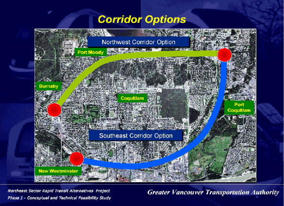
• the Northwest Corridor is the traditional route via North Road, through Port Moody to Coquitlam, with several specific alignments considered. Since there is no existing heavy-rail alignment in the Northwest Corridor, DMU was not considered an option here.

For the remaining technologies, the only alignment considered in Burnaby was along North Road. GLT or LRT would operate in the centre of the roadway, and SkyTrain would be overhead. A previous TransLink decision established a centre road alignment for SkyTrain along North Road from Gatineau Place to north of Foster Avenue. The Lougheed Town Centre station has a pre-built section for a Northeast SkyTrain extension via a centre median North Road alignment. Moreover considerable effort and expense were involved in developing a complex series of switches and trackwork at the Lougheed Town Centre Station to allow for the interlining of SkyTrain vehicles. If trains were interlined at this station a transfer could be eliminated for people travelling between the Millennium Line and Coquitlam Centre.

The B-Line service would presumably maintain the existing North Road stops at Austin, Cameron, and Foster. These existing stops would be eliminated under all options using a different technology.

As Clarke Road descends into Port Moody, the grade is too steep for LRT. A tunnel, similar to that proposed for SkyTrain, would be needed to create a gentler grade. The report indicates that some GLT vehicles might also need a tunnel for the same reason, but the GLT options are priced on the assumption that an at-grade alignment is possible.

B-Line and GLT would have the option of being extended to Port Coquitlam, whereas LRT and SkyTrain would terminate in the Coquitlam Centre area.

• the Southeast Corridor starts in the Sapperton area of New Westminster and follows Lougheed Highway and/or the CP Rail tracks eastward to Cape Horn, past Colony Farm and then northward to Coquitlam Town Centre. The Southeast Corridor does not pass through Burnaby.

As a GLT or LRT service, transit would start at Braid SkyTrain Station, heading east on the proposed United Boulevard Extension and then north on King Edward. From there, Lougheed Highway and Pinetree Way would provide the route to Coquitlam City Centre and City Hall. SkyTrain would be similar, but would avoid the United Boulevard Extension. GLT would have a spur routing to Port Coquitlam, but LRT and SkyTrain would not.

The DMU option would use the existing CP Rail tracks. It would start at Sapperton SkyTrain station and then generally parallel the Lougheed Highway. New track would be constructed northward from Barnet Highway to Coquitlam Centre and Coquitlam City Hall, likely below grade in an open cut. This would be the main route, and most frequently served. However, it was recognized that spur routings to both Port Moody and Port Coquitlam could be provided in existing rail corridors. Accordingly, Phase 1 is based on a three-way split of DMU, with Coquitlam Centre getting half the trains, and 25% each to Port Moody and Port Coquitlam.

B-Line was not considered for the Southeast Corridor. If the Southeast Corridor was constructed (with another technology), the existing B-Line service in the Northwest Corridor would be retained, as it provides shorter travel times from Port Moody to most regional destinations.

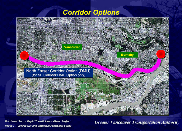
• The North Fraser Corridor starts at Sapperton, extends southward to the downtown New Westminster waterfront and then westward through the Big Bend area in Burnaby. It remains south of Marine Way / Marine Drive, and extends to Cambie Street in Vancouver. This would allow for a connection to the Richmond / Airport / Vancouver Rapid Transit Project (subject to approval). While any of the stated technologies could operate in this corridor, TransLink chose to only consider DMU on the existing CP Rail tracks. This would only occur if DMU in the Southeast Corridor was the final choice for the Northeast Sector.

In the North Fraser Corridor, Burnaby staff had suggested two DMU stations in Big Bend: Marshland Avenue and Boundary Road. These stations would serve both ends of this growing industrial area, facilitated by a bus link between the two stations along North Fraser Way. As a fallback, if only one station was to be provided, then Byrne Road was the suggested location. This is the option that was included in the study.

The primary focus of this study was on the Northeast Sector; therefore, the North Fraser Corridor received relatively little attention. This latter element should be viewed as a longer term option.


It should be noted that the above alignment descriptions are considered “representative” for analysis and costing. There is an opportunity for these to be refined through further analysis during Phase 2.
https://burnaby.civicweb.net/document/5212


http://council.vancouver.ca/20040113/tt1.htm


http://council.vancouver.ca/20040113/tt1.htm
Reply With Quote
     
     
This discussion thread continues

Use the page links to the lower-right to go to the next page for additional posts
 
 
Reply

Go Back   SkyscraperPage Forum > Regional Sections > Canada > Alberta & British Columbia > Vancouver > Transportation & Infrastructure
Forum Jump


Forum Jump


All times are GMT. The time now is 9:32 AM.

     
SkyscraperPage.com - Archive - Privacy Statement - Top

Powered by vBulletin® Version 3.8.7
Copyright ©2000 - 2024, vBulletin Solutions, Inc.