Interesting statistics, but are they telling the true story? Are the intersections along Hunt Club really the most dangerous?
I would like to see the volumes of traffic included in the charts so that we can get a better idea of how many accidents there are for the number of intersection traverses. If there is one accident every two weeks at an intersection which sees 50,000 vehicles crossing it every day is that not safer than an intersection which has two accidents in a year but only sees 1,000 vehicles in a day? In the first case, the busy intersection has 26 accidents per year, but only one accident for every 700,000 vehicles passing; in the less busy case, there are only two accidents in the year, but one in 182,500 vehicles crashes.
The intersections along the stretch of Hunt Club Road, between Bank and Greenbank Roads, are where virtually all of the people driving out of Barrhaven and parts south cross when heading north, into the city. Hunt Club, itself, carries a fairly high volume of traffic since it is one of the few west-east connectors across the Rideau River. (Although that may be helped by the opening of the Strandherd-Armstrong Bridge, it might also be worsened by connecting Hunt Club to the 417.) With the volumes of traffic passing through the intersections along Hunt Club, it is no surprise that they have the highest absolute accident counts.
I think that what these statistics are really pointing out is that there is need of a large, limited access, conduit for traffic from the south to the north to safely carry the bulk of the traffic; a road that is between the 416 and the eastern 417, perhaps following the river. But it is unlikely that that could ever be built.
Looking at the intersections with the most collisions in 2013, I see, counting down from the worst, Hunt Club, Hunt Club, Hunt Club, and Hunt Club in the first four positions where Hunt Club is crossed by Barrhaven traffic. Then I see St. Laurent and St. Laurent in positions five and six; which is another busy north-south road. Then briefly back to Hunt Club and Hunt Club for spots seven and nine; although there accident numbers are slightly lower as Greenbank is a bit further west and Bank a bit further east than the main desire line of the traffic.
The above intersections all suffer from large traffic volumes of north-south traffic and a solution to this would be very expensive. However, the intersections in spot eight and tied for spot nine are interesting, Blair Road and the 174 west-bound off-ramp and Blair at Ogilvie Road, respectively. Granted the intersection of the 174 west-bound off-ramp is a bit of a mess with the weave between vehicles coming off the 174 to get to Ogilvie and vehicles trying to turn into the Commerce Park, but I think that the off-ramp traffic is a lot of the same traffic which is going through the Ogilvie Road intersection; likely turning left onto Ogilvie. I think that I would group these two intersections and deal with the problem of too much traffic from the east trying to get onto the Aviation Parkway. I say that the traffic is likely headed for the Aviation Parkway because the intersection of Ogilvie and St. Laurent (which we know to also be a very busy road) is not listed as a problem spot.
I think that adding free-flow ramps directly from the 174 to the Aviation Parkway would help solve the problems along Blair. Better still, complete the interchange so that there are direct ramps from and to all directions, like thus:
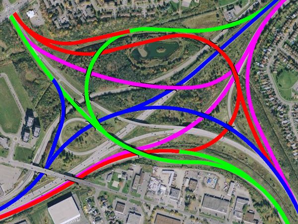
The colours represent the direction that the vehicle is leaving; Blue is west, Green is south, Fuchsia is east, and Red is north. The curves are large for high speeds and diverges happen before any merges - so no weaving.
This would also make it much easier for connections to the new Inter-provincial Bridge when it is finally constructed.
Getting back to the worst intersections, where and how would any of you solve the volume of traffic coming from the Barrhaven area heading north? Riverside connected to Nicholas? Prince of Wales and the Champagne Corridor?


 Prev
Prev


 Linear Mode
