HomeDiagramsDatabaseMapsForum About
     

Go Back   SkyscraperPage Forum > Regional Sections > Canada


Closed Thread

 
Thread Tools Display Modes
     
     
  #9601  
Old Posted Jun 13, 2022, 9:52 PM
sonysnob sonysnob is online now
Registered User
 
Join Date: Aug 2011
Posts: 1,797
Quote:
Originally Posted by Acajack View Post
Not an expert but to my eye that's not quite the same as the overhead sign gantries used in Quebec. Though it's very close.
These aren't the ones that Quebec uses, this is an Ontario design. Seemingly all of the overheads that were constructed on the Fredericton to Moncton Highway use an Ontario overhead sign design.
     
     
  #9602  
Old Posted Jun 14, 2022, 1:09 AM
sonysnob sonysnob is online now
Registered User
 
Join Date: Aug 2011
Posts: 1,797
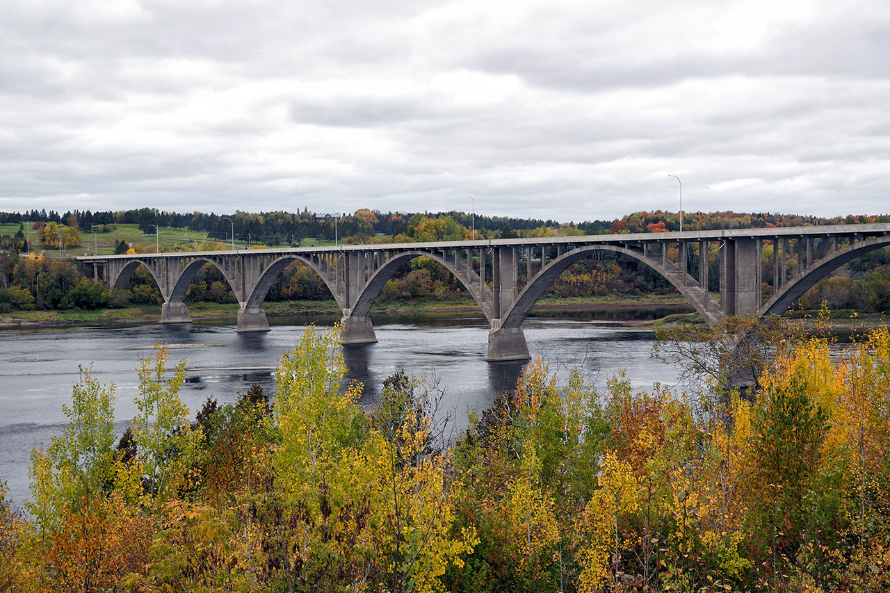
A few photos of the open spandrel concrete arch bridge that formerly carried the Trans-Canada Highway overtop of the St. John River in Hartland New Brunswick. Hartland is the site of the world's longest covered bridge, but to me, this structure is more interesting:


http://www.asphaltplanet.ca/NB/130/NB130_cl_DSC02501_Oct21_24x16.jpg


http://www.asphaltplanet.ca/NB/130/NB130_cl_DSC02512_Oct21_24x16.jpg
     
     
  #9603  
Old Posted Jun 14, 2022, 2:03 AM
Dengler Avenue's Avatar
Dengler Avenue Dengler Avenue is offline
Road Engineer Wannabe
 
Join Date: Sep 2017
Location: Côté Ouest de la Rivière des Outaouais
Posts: 8,669
N.B.-130 has a couple of interchanges on the east side of the river. I’ve always been amazed that New Brunswick wouldn’t mind ditching former super-2’s in favour of new alignment.
__________________
My Proposal of TCH Twinning in Northern Ontario
Disclaimer: Most of it is pure pie in the sky, so there's no need to be up in the arm about it.
     
     
  #9604  
Old Posted Jun 14, 2022, 3:04 PM
sonysnob sonysnob is online now
Registered User
 
Join Date: Aug 2011
Posts: 1,797
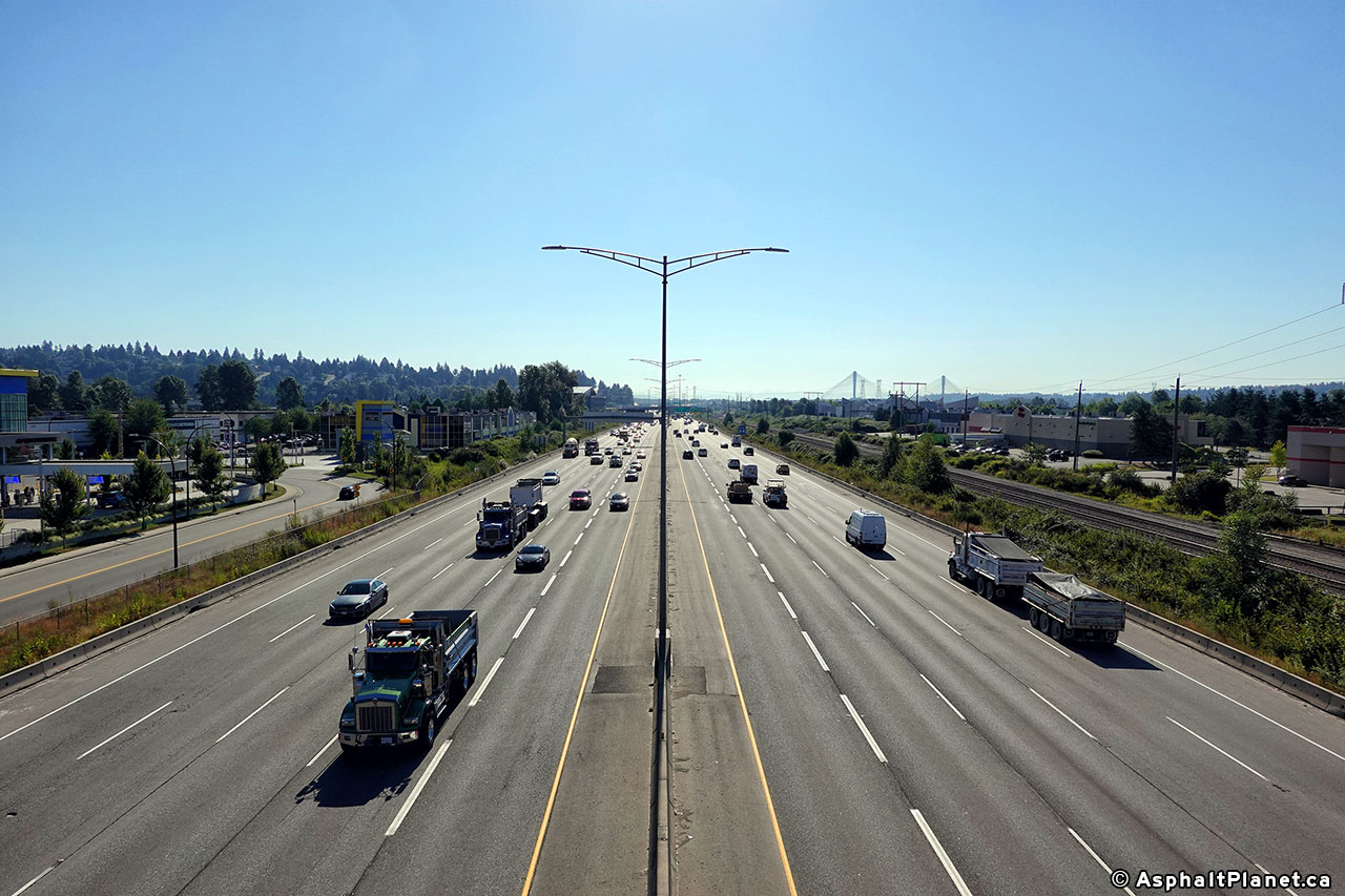
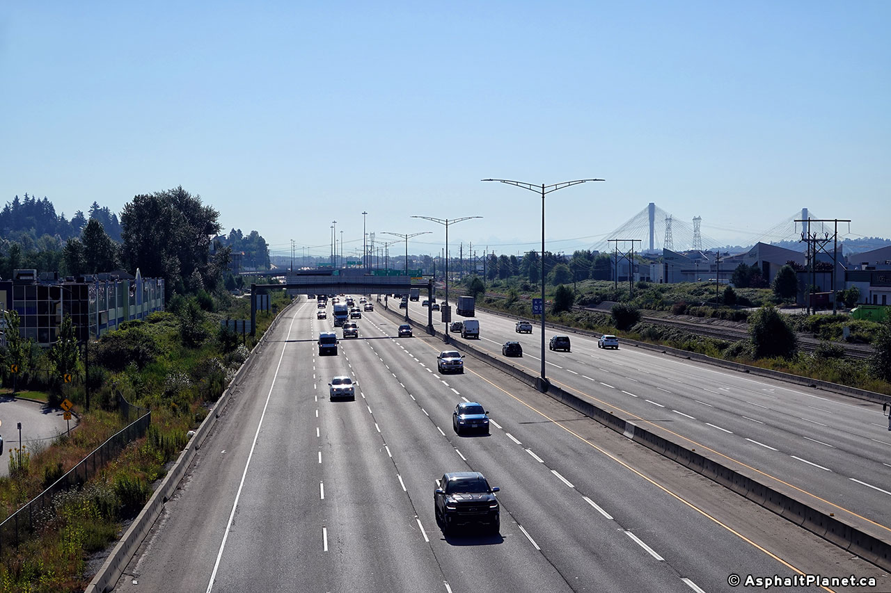
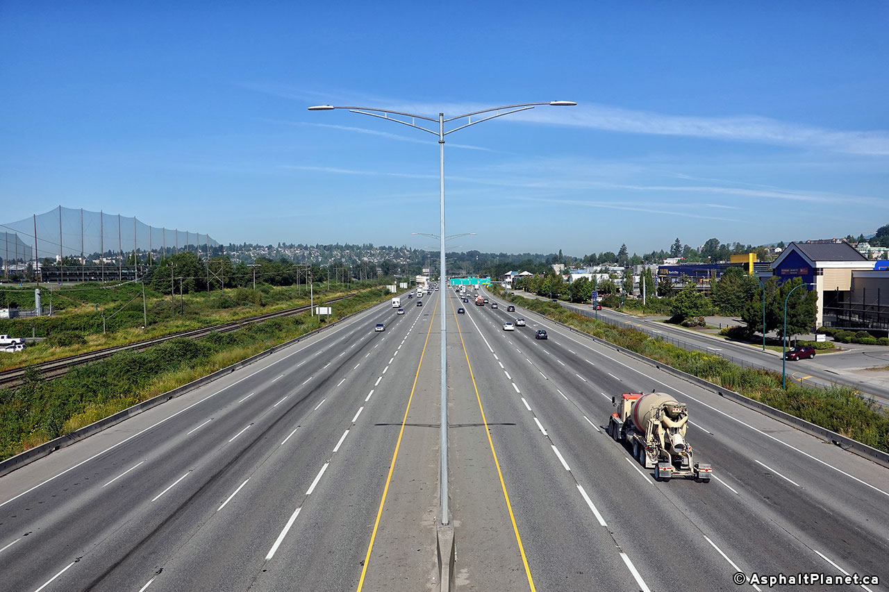
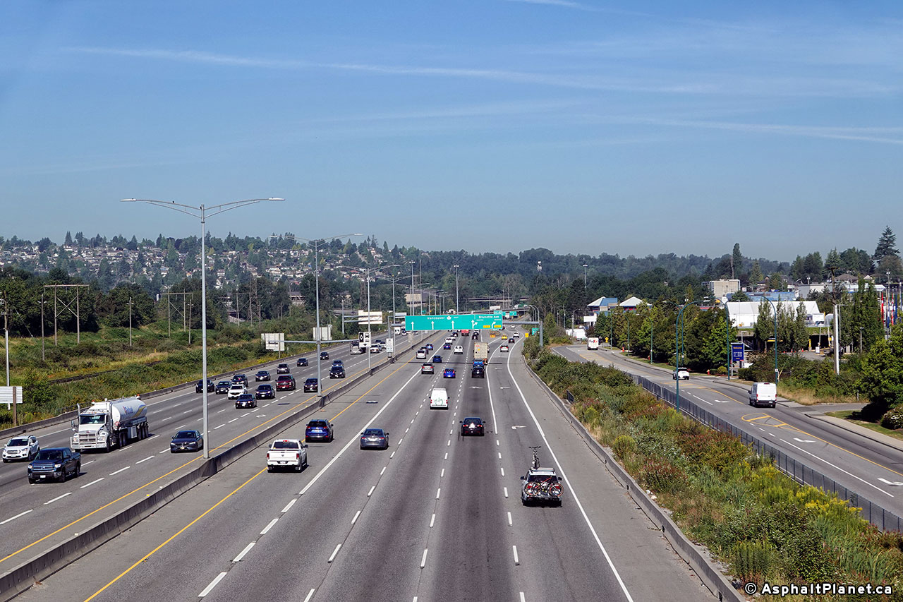
Some photos of the Trans-Canada Highway in BC through the Cape Horn interchange. These photos were taken during the Summer of 2020:

Two views looking easterly towards the Port Mann Bridge from the King Edward Drive overpass:

http://www.asphaltplanet.ca/BC/1/BC1_cl_DSC03683_west_c_Jul20_24x16.jpg


http://www.asphaltplanet.ca/BC/1/BC1_cl_DSC03688_east_WB_Jul20_24x16.jpg

Two views looking easterly towards Vancouver:

http://www.asphaltplanet.ca/BC/1/BC1_cl_DSC03673_west_c_Jul20_24x16.jpg


http://www.asphaltplanet.ca/BC/1/BC1_cl_DSC03672_west_WB_Jul20_24x16.jpg
     
     
  #9605  
Old Posted Jun 14, 2022, 6:51 PM
Acajack's Avatar
Acajack Acajack is offline
Gros Méchant Loup
 
Join Date: Aug 2006
Location: Province 2, Canadian Empire
Posts: 72,949
Quote:
Originally Posted by sonysnob View Post
These aren't the ones that Quebec uses, this is an Ontario design. Seemingly all of the overheads that were constructed on the Fredericton to Moncton Highway use an Ontario overhead sign design.
Even though I drive on their highways regularly, I think my view of Ontario's gantries is out-dated.

I still have in mind the classic joint-free ones with curved top corners.
__________________
Loin des yeux, loin du coeur.
     
     
  #9606  
Old Posted Jun 15, 2022, 12:05 AM
Djeffery's Avatar
Djeffery Djeffery is offline
Registered User
 
Join Date: Oct 2017
Location: London
Posts: 6,236
Quote:
Originally Posted by sonysnob View Post
A few photos of the open spandrel concrete arch bridge that formerly carried the Trans-Canada Highway overtop of the St. John River in Hartland New Brunswick. Hartland is the site of the world's longest covered bridge, but to me, this structure is more interesting:
Cool bridge. I think this was still the TCH the last time I drove down that way. If I remember right, this piece to the north of Woodstock was one of the last sections that wasn't 4 laned. But I could be wrong.
     
     
  #9607  
Old Posted Jun 17, 2022, 12:14 AM
sonysnob sonysnob is online now
Registered User
 
Join Date: Aug 2011
Posts: 1,797
A view looking southerly along the Décarie Expressway in Montreal, taken in May, 2021:


http://www.asphaltplanet.ca/PQ/A/15/A15_cl_63-25_south_SB_May21_24x16.jpg
     
     
  #9608  
Old Posted Jun 17, 2022, 2:22 PM
sonysnob sonysnob is online now
Registered User
 
Join Date: Aug 2011
Posts: 1,797
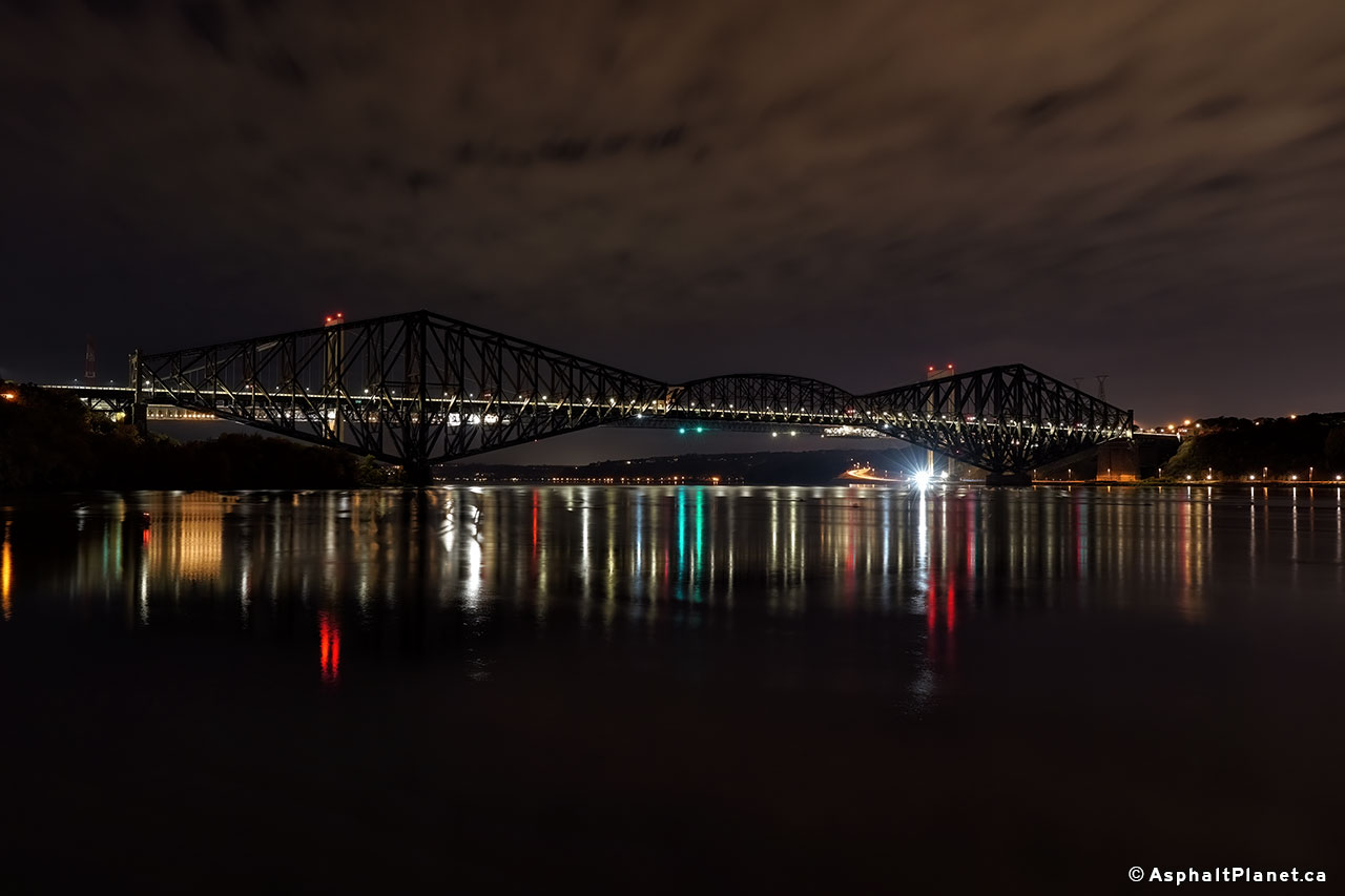
Night view of the old Quebec Bridge taken last October:


http://www.asphaltplanet.ca/PQ/A/73/A73_QuebecBridge_northwest_Oct21_24x16.jpg
     
     
  #9609  
Old Posted Jun 19, 2022, 2:11 AM
swimmer_spe swimmer_spe is offline
BANNED
 
Join Date: Apr 2014
Posts: 10,743
I notice that depending on what you are driving and where you are going, you want different things out of a highway.

When I am heading to the city, I want a divided highway with a high rate of speed.

When I am towing my camping trailer I want lots of passing lanes and no hills.

When I am on my motorcycle, I want twisty, curvy and hilly open roads with no traffic.
     
     
  #9610  
Old Posted Jun 19, 2022, 4:33 AM
harls's Avatar
harls harls is online now
Mooderator
 
Join Date: Jan 2002
Location: Aylmer, Québec
Posts: 21,372
Sonysnob gets around
     
     
  #9611  
Old Posted Jun 20, 2022, 1:51 AM
FrAnKs's Avatar
FrAnKs FrAnKs is offline
Registered User
 
Join Date: Jul 2005
Location: Ville de Québec / Quebec city
Posts: 5,930
Here's my newest video of Highway 400 through the Muskoka & Parry Sound areas!

Video Link
__________________
PROVINCE OF QUEBEC ==> 9 050 000
MONTREAL METRO ==> 4 600 000
QUEBEC CITY METRO ==> 900 000
     
     
  #9612  
Old Posted Jun 20, 2022, 4:24 PM
Taeolas Taeolas is offline
Registered User
 
Join Date: Oct 2009
Location: Fredericton
Posts: 5,017
Quote:
Originally Posted by Djeffery View Post
Cool bridge. I think this was still the TCH the last time I drove down that way. If I remember right, this piece to the north of Woodstock was one of the last sections that wasn't 4 laned. But I could be wrong.
The Hugh John Flemming Bridge. It is a beautiful bridge, but I think it's overdue for a major overhaul. There was reluctance to do the overhaul last I heard because it would need a full closure and there was worries about services across the river. (Most of Hartland is on the east side of the river, but the regional hospital and the TCH is now routed on the west side). *Googling it seems the work may have been done back in 2010... Damn where has the time gone?*

And while this wasn't the final twinned section (that honor belongs to the Quebec border to Edmundston stretch I believe), it was one of the final sections, because it was a complete new build. From Hartland to Florenceville, they built the new alignment on the west side of the river, whereas before it crossed the river at those locations; thus saving the cost of four major bridges (as the existing bridges would not meet modern highway standards). The valley is more spread out at Florenceville so the bridge wouldn't have been as high, but the Hartland valley walls are very high where the old TCH routed, as you can see from the pics above, so that would have been a major bridge pair, probably on pair with the bridges crossing the Saint John south of Fredericton (and again crossing at Jemseg).

     
     
  #9613  
Old Posted Jun 20, 2022, 5:29 PM
sonysnob sonysnob is online now
Registered User
 
Join Date: Aug 2011
Posts: 1,797
I've always thought that it was too bad they didn't bother to repair the old bridge at Jesmeg.

I certainly understand it, the old Jesmeg Bridge would have been expensive to repair, and the new four lane highway certainly can manage all of the existing traffic, but the old Jesmeg Bridge is in its own right an interesting highway bridge, that I would have rather seen retained.
     
     
  #9614  
Old Posted Jun 22, 2022, 2:53 AM
sonysnob sonysnob is online now
Registered User
 
Join Date: Aug 2011
Posts: 1,797
     
     
  #9615  
Old Posted Jun 23, 2022, 1:41 PM
LightingGuy LightingGuy is offline
Closed account
 
Join Date: Jun 2022
Location: KW
Posts: 728
Any insiders on the 413 project? Now that Ford got re-elected is it pretty much a sure thing, or is there still a lot of red tape to jump through?
     
     
  #9616  
Old Posted Jun 23, 2022, 2:22 PM
ericmacm's Avatar
ericmacm ericmacm is online now
Registered User
 
Join Date: Jul 2017
Location: SW Ontario
Posts: 957
Quote:
Originally Posted by LightingGuy View Post
Any insiders on the 413 project? Now that Ford got re-elected is it pretty much a sure thing, or is there still a lot of red tape to jump through?
Not an insider, but they still haven’t completed the Provincial EA. There is also the Federal EA process on top of that, but that has the potential to not impact the timeline if the Provincial EA satisfies the requirements identified in the Federal EA consultation process.
__________________
Opinions expressed here are solely my own.

Come See My Work: Pan-Canadian Skylines Project​​​ | Astrophotography Thread
     
     
  #9617  
Old Posted Jun 23, 2022, 2:28 PM
Innsertnamehere's Avatar
Innsertnamehere Innsertnamehere is online now
Registered User
 
Join Date: Jan 2010
Location: Hamilton
Posts: 12,831
The Federal EA process is what is holding the project up right now. The provincial EA would be wrapping up right now if not for that.

The Bradford Bypass is scheduled for construction in 2024/2025, but the 413 still has a while to go.

Ford is going to have to push hard to get design done and a construction contract signed by the end of his 4-year term. If that can happen, construction will likely wrap up on the highway towards the end of the decade at the soonest.
     
     
  #9618  
Old Posted Jun 23, 2022, 2:39 PM
sonysnob sonysnob is online now
Registered User
 
Join Date: Aug 2011
Posts: 1,797
An advanced contract for an overpass at Yonge Street at the Bradford Bypass was called this spring. I haven't been up that way this year, but I'd expect barrels lining Yonge Street already.

The County of Simcoe was pushing for these advanced works, as they want to widen Yonge Street north of Bradford, and they didn't want to spend money to widen a road that was going to be immediately thrown away as part of the works to build Bradford.

There was also a pretty big push to get a contract signed before the election.

*edit* the Bradford By-pass is Hwy 7317 at present.

Last edited by sonysnob; Jun 23, 2022 at 3:07 PM.
     
     
  #9619  
Old Posted Jun 23, 2022, 6:15 PM
LightingGuy LightingGuy is offline
Closed account
 
Join Date: Jun 2022
Location: KW
Posts: 728
I took a gander at the new SW leg of the Stoney Trail on google street this morning and was surprised at how wide the ROW is.

https://goo.gl/maps/TSbfBYPWiZ8wegyq7
     
     
  #9620  
Old Posted Jun 23, 2022, 6:18 PM
GreaterMontréal's Avatar
GreaterMontréal GreaterMontréal is offline
Registered User
 
Join Date: Dec 2013
Posts: 4,628
The Minister of Transport and Minister responsible for the Estrie region, Mr. François Bonnardel, and the MNA for Nicolet-Bécancour, Mr. Donald Martel, today announced a major investment of $340 million for the redevelopment of the Highway 55 between Bécancour and Sainte-Eulalie. The project will double the traffic lanes over 27.1 km, add a physical separation between the two directions and redevelop the four at-grade intersections located on this section.

https://www.transports.gouv.qc.ca/fr/pro...u-quebec/PublishingImages/A-55_Carte.jpg
     
     
This discussion thread continues

Use the page links to the lower-right to go to the next page for additional posts
 
 
Closed Thread

Go Back   SkyscraperPage Forum > Regional Sections > Canada
Forum Jump


Forum Jump


All times are GMT. The time now is 4:08 AM.

     
SkyscraperPage.com - Privacy Statement - Top

Powered by vBulletin® Version 3.8.7
Copyright ©2000 - 2026, vBulletin Solutions, Inc.