HomeDiagramsDatabaseMapsForum About
     

Go Back   SkyscraperPage Forum > Regional Sections > Canada


Closed Thread

 
Thread Tools Display Modes
     
     
  #8761  
Old Posted Jan 20, 2021, 4:05 PM
wave46 wave46 is offline
Closed account
 
Join Date: Aug 2016
Posts: 3,875
Quote:
Originally Posted by swimmer_spe View Post
The worst in ON that is part of a freeway, is actually under construction. It's the 400 split. You might see nothing wrong with it. However, drive it when you can do the highway speed Only to have to brake going up hill for the ramp. Also, it is a left hand exit. Highway 11 north exits to the left, and then comes in on the left. And you have lanes of the thru highway;400 South, ending right where 11 is. Consider that this is always a bottleneck on long weekends.
The 400 split isn't bad. If it only jams up at the worst traffic times, meh? The ramps are designed for reasonably high speeds. There's capacity issues on long weekends going north on 11, but that's peanuts.

Bad design is any cloverleaf interchange with lots of weaving. Left exits. Merge or die ramps that one is blind to the flow of traffic until the moment they have to merge. Ultra-tight loops that require one to slow to a seeming walking pace then accelerate wide open. Mysterious podunk accesses, because reasons.

Ontario does fairly well with highway design, simply because most of the highway network is newer and was built with reasonable right-of-ways. The MTO didn't bulldoze its way through cities.

Generally, the poorest interchange designs are ones found on freeways in previously built-up urban areas.
     
     
  #8762  
Old Posted Jan 20, 2021, 4:40 PM
hipster duck's Avatar
hipster duck hipster duck is online now
Registered User
 
Join Date: Oct 2014
Location: Toronto
Posts: 4,869
Quote:
Originally Posted by Dengler Avenue View Post
I should start another one on 404/401.
I think the 404 bottleneck (the 401 doesn't have any design problems through there) can be solved relatively easily:

- Close the Sheppard to SB-404/DVP entrance. At the very least add about 300m of Jersey barrier here so you can only exit to the 401.

- Close the SB-DVP to York Mills cloverleaf and York Mills to NB-404/401 cloverleaf.
     
     
  #8763  
Old Posted Jan 20, 2021, 5:48 PM
Franco401 Franco401 is offline
Registered User
 
Join Date: Jan 2014
Location: Fredericton
Posts: 1,238
Some other bad ones around NB:

This one will soon be improved on the south side when the cloverleafs are removed, but what this image doesn't convey is that for about 20 years on the north and 30 years on the south side, the elevated offramps weren't even built.


Another weird one: Route 7 NB narrows to one lane, only to add a lane for the exit. The twinning was done after the ramp! They didn't have to! The plan is even to twin it further north so there's no excuse for this!


Yeah, let's add a little stub of road here in case someone wants to build something later... on the side of a mountain... in the middle of nowhere.


This didn't need to be half as complicated as it is.


This is what happens when you fail to coordinate old and new road systems where a huge new freeway alignment ends.


Why does this happen so much?


Level crossing on a freeway, no overpass to the airport. Next.


This wasn't even necessary. A diamond would have been fine! A regular Parclo would be better!


Same here.


Never actually drove this myself but it seems insane to build a huge bridge with an approach road and not directly connect it to the TCH.


  #8764  
Old Posted Jan 20, 2021, 5:56 PM
Dengler Avenue's Avatar
Dengler Avenue Dengler Avenue is offline
Road Engineer Wannabe
 
Join Date: Sep 2017
Location: Côté Ouest de la Rivière des Outaouais
Posts: 8,673
Quote:
Originally Posted by Franco401

Never actually drove this myself but it seems insane to build a huge bridge with an approach road and not directly connect it to the TCH.

For the last time, check the SFPR (Highway 17) thread in Vancouver. I attempted a redesign there.

I think that 8 & 11 in Bathurst is a bad one too. IMO, when 2 freeways meet, even if they’re super-2, they should be widened to divided 4 lanes at the interchange then back down to undivided 2 lanes after. Something similar to what I just described is 17&69 outside of Sudbury, ON. The divided section is 1.5 km long (750 m each side).
__________________
My Proposal of TCH Twinning in Northern Ontario
Disclaimer: Most of it is pure pie in the sky, so there's no need to be up in the arm about it.

Last edited by Dengler Avenue; Jan 20, 2021 at 6:00 PM. Reason: please don't quote a million photos in a post
     
     
  #8765  
Old Posted Jan 20, 2021, 6:07 PM
Taeolas Taeolas is online now
Registered User
 
Join Date: Oct 2009
Location: Fredericton
Posts: 5,036
Quote:
Originally Posted by Franco401 View Post
Some other bad ones around NB:

This wasn't even necessary. A diamond would have been fine! A regular Parclo would be better!


This one always boggles me. Especially when you realize that that is the main route between Fredericton and New Maryland, so the road under the TCH has a lot of traffic (especially at the start and end of day), and the traffic FROM Freddy has to CROSS THE ROAD to get onto the TCH in either direction.

And personally, I find the direction sign confusing. To go westbound to Edmundston, you need to take the first left. To go to Moncton and SJ eastbound, you need to take the second left. But the sign shows the second destination on top, and the "Up then left" arrow for Edmundston combined with its location second on the sign to me implies you should continue under the highway and then turn left, even though that doesn't make sense.

What's worse, is they already have all the parts they need to do right hand exits/entrances on all sides as mentioned. Hell, they could put roundabouts on the New Maryland highway for the entrance/exits and it would be a major improvement.
     
     
  #8766  
Old Posted Jan 20, 2021, 6:13 PM
Dengler Avenue's Avatar
Dengler Avenue Dengler Avenue is offline
Road Engineer Wannabe
 
Join Date: Sep 2017
Location: Côté Ouest de la Rivière des Outaouais
Posts: 8,673
It must be the relic of the days when TCH freeway used to be tolled.
The roundabout from 102 to 7 near Oromocto might also be a relic from the days when TCH used to go on a different alignment. One can see evidence that an overpass(!) was torn down.
__________________
My Proposal of TCH Twinning in Northern Ontario
Disclaimer: Most of it is pure pie in the sky, so there's no need to be up in the arm about it.
     
     
  #8767  
Old Posted Jan 20, 2021, 7:17 PM
Franco401 Franco401 is offline
Registered User
 
Join Date: Jan 2014
Location: Fredericton
Posts: 1,238
Quote:
Originally Posted by Dengler Avenue View Post
It must be the relic of the days when TCH freeway used to be tolled.
The roundabout from 102 to 7 near Oromocto might also be a relic from the days when TCH used to go on a different alignment. One can see evidence that an overpass(!) was torn down.
The one I posted from Longs Creek actually dates from when the Mactaquac Dam flooded the valley in the 60s, forcing the creation of what is now the 2-lane 102. The trumpet was the connection to Route 3, with the roundabout merely home to a weigh station. The thing that makes it stupid now is that no changes were made when the freeway was built, so Route 3 traffic has to deal with several intersections, then a pointless circle, then the trumpet.

As for Oromocto, you're half right. When Route 2 was still following what is now Route 105 through Maugerville, Oromocto actually had better highway access than today.

Here's how the current exit 301 appeared in 1998. Today there are only ramps to and from Fredericton here. Part of this was first built when Oromocto became an actual town with the creation of CFB Gagetown. The bridge section of Route 7 was built in 1976 and twinned in the 90s in preparation for the Route 2 project.


Since the Gateway area ajacent to exit 303 hadn't been built, the roundabout you mentioned was only a "T" intersection.

There was once an overpass just north of the current Route 2/Route 7 split.

Here's how it would have appeared (no free imagery):

(correction: on the right I wrote (this section of Route 2...; it is actually Route 7)
     
     
  #8768  
Old Posted Jan 22, 2021, 3:05 PM
GoTrans GoTrans is offline
Registered User
 
Join Date: Jan 2010
Posts: 695
Quote:
Originally Posted by swimmer_spe View Post
The worst interchange I have seen was not even on a freeway. It is where the end of Lions Gate Bridge hits Marine Drive. The reason? The signage to tell you what lane to be in is right where you need to be in that lane. Great if it is your regular route, but, if not, it really is annoying.

The worst in ON that is part of a freeway, is actually under construction. It's the 400 split. You might see nothing wrong with it. However, drive it when you can do the highway speed Only to have to brake going up hill for the ramp. Also, it is a left hand exit. Highway 11 north exits to the left, and then comes in on the left. And you have lanes of the thru highway;400 South, ending right where 11 is. Consider that this is always a bottleneck on long weekends.
The 400/11 interchange is not that bad. Just because on holiday weekends, both highways are jammed with people going to their cottages does not make it a bad highway. Just remember that Hwy 11 was built first and that Hwy 400 ended at at Hwy 11. What is bad is, is Hwy 11 between the Jct going north as far as Gravenhurst as a none separated road with frequent pull offs to businesses and homes. Then there is the colossal failure at the south exit to Gravenhurst on the southbound where Hwy 11 branches off from the old Hwy 11 which ran through town as there is a sharp curve with warning lights. Trucks have been known to flip on the curve. After that Hwy 11 is basically grade separated the whole way to North Bay.
     
     
  #8769  
Old Posted Jan 22, 2021, 3:45 PM
Dengler Avenue's Avatar
Dengler Avenue Dengler Avenue is offline
Road Engineer Wannabe
 
Join Date: Sep 2017
Location: Côté Ouest de la Rivière des Outaouais
Posts: 8,673
Quote:
Originally Posted by GoTrans View Post
The 400/11 interchange is not that bad. Just because on holiday weekends, both highways are jammed with people going to their cottages does not make it a bad highway. Just remember that Hwy 11 was built first and that Hwy 400 ended at at Hwy 11. What is bad is, is Hwy 11 between the Jct going north as far as Gravenhurst as a none separated road with frequent pull offs to businesses and homes. Then there is the colossal failure at the south exit to Gravenhurst on the southbound where Hwy 11 branches off from the old Hwy 11 which ran through town as there is a sharp curve with warning lights. Trucks have been known to flip on the curve. After that Hwy 11 is basically grade separated the whole way to North Bay.
I’m at work right now. Remind me to show you both some pictures of proposed changes to ON-11 after 4:30 pm EST.
__________________
My Proposal of TCH Twinning in Northern Ontario
Disclaimer: Most of it is pure pie in the sky, so there's no need to be up in the arm about it.
     
     
  #8770  
Old Posted Jan 22, 2021, 4:20 PM
Innsertnamehere's Avatar
Innsertnamehere Innsertnamehere is offline
Registered User
 
Join Date: Jan 2010
Location: Hamilton
Posts: 12,832
Quote:
Originally Posted by GoTrans View Post
The 400/11 interchange is not that bad. Just because on holiday weekends, both highways are jammed with people going to their cottages does not make it a bad highway. Just remember that Hwy 11 was built first and that Hwy 400 ended at at Hwy 11. What is bad is, is Hwy 11 between the Jct going north as far as Gravenhurst as a none separated road with frequent pull offs to businesses and homes. Then there is the colossal failure at the south exit to Gravenhurst on the southbound where Hwy 11 branches off from the old Hwy 11 which ran through town as there is a sharp curve with warning lights. Trucks have been known to flip on the curve. After that Hwy 11 is basically grade separated the whole way to North Bay.
That interchange is fine. It's not a left hand exit because the lanes are configured to through run onto 11, with the 400 exiting on the right hand side. If it was signed differently it wouldn't confuse anyone. It also operates absolutely fine from a capacity perspective.

I get people complain about that but about 70% of traffic goes onto 11 and only about 30% continues up the 400 so it makes sense from a volume perspective to have 11 be the main through route.

It also isn't unusual at all to have highways require an exit - it's just Ontario that sees it as odd. US Interstate routes take exits all the time.

11 Definitely has design standard issues. Especially south of Orillia, where traffic volumes are approaching the need for a 6 lane freeway facility. The right in right out model works OK for lower volume highways as it's easy to find gaps in traffic to pull out of roadside businesses, but 11 south of Orillia is so busy that's very challenging.

Even north of Orillia it's starting to get too busy to really function well, but not to the same extent. One tims/gas station particularly SB from Gravenhurst always causes problems. Webers used to also cause issues but they added a right turn lane there a year or two ago that mostly fixes it.

Yea, the Gravenhurst connection is very substandard. MTO did an EA to address it a few years ago however, I wouldn't be surprised if they re-align that bit as an interim measure in the next decade or so.
     
     
  #8771  
Old Posted Jan 22, 2021, 4:55 PM
Dengler Avenue's Avatar
Dengler Avenue Dengler Avenue is offline
Road Engineer Wannabe
 
Join Date: Sep 2017
Location: Côté Ouest de la Rivière des Outaouais
Posts: 8,673
__________________
My Proposal of TCH Twinning in Northern Ontario
Disclaimer: Most of it is pure pie in the sky, so there's no need to be up in the arm about it.

Last edited by Dengler Avenue; Jan 22, 2021 at 5:36 PM. Reason: @sonysnob has a better one.
     
     
  #8772  
Old Posted Jan 22, 2021, 9:06 PM
swimmer_spe swimmer_spe is offline
BANNED
 
Join Date: Apr 2014
Posts: 10,743
That is nice to see. I really like how they are finally fixing the mess at 169.
     
     
  #8773  
Old Posted Jan 22, 2021, 9:40 PM
someone123's Avatar
someone123 someone123 is offline
hähnchenbrüstfiletstüc
 
Join Date: Nov 2001
Location: Vancouver
Posts: 35,769
Quote:
Originally Posted by hipster duck View Post
A 4-level stack might be a bit overkill for suburban Halifax, but based on this "armchair civil engineer's" Google Streetview tour, that interchange looks like it's nearing the end of its structural life, and it should be completely redesigned anyway.
A bit of trivia: that is called "Bicentennial Dr." because it was originally dedicated to a bicentennial, although which one is a bit unclear. 1958 was the bicentennial for the NS legislature and elected assembly. The first portion of this highway opened in 1949 which was the Halifax bicentennial. This is probably one of the older controlled access freeways in Canada. Wikipedia says it is the oldest in Atlantic Canada.

Metro Halifax is a bit unusual in that the traffic is highly irregular. You can find some interchange out in the woods somewhere that handles much more traffic than what the immediate area generates because there are so few crosstown arteries and there are so many natural obstacles. This interchange is where 2 corridors intersect and the only Bedford Basin/harbour crossing is about 7 km south. It does not just serve Bedford and Sackville.

Around Halifax there are generally 2 sets of arteries, the new 100 series highways and the old trunk routes. For example Sackville Drive is part of NS Trunk 1 which was the old Annapolis road dating back to the 1700's. The 101 is the modern highway for that route. Highway 2 is the old road to Truro and follows near the 102, 3 is the old Lunenburg road that has the 103.
     
     
  #8774  
Old Posted Jan 22, 2021, 11:46 PM
someone123's Avatar
someone123 someone123 is offline
hähnchenbrüstfiletstüc
 
Join Date: Nov 2001
Location: Vancouver
Posts: 35,769
I thought this was an interesting find:

Quote:
Originally Posted by q12 View Post
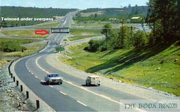
Here is the interchange before the entire Bi-Hi was twinned in the early 60's. Notice the overpass was built over a short twinned section of the 102 Bi-Hi.


Orientation: Looking North on the 102 before the Bedford Bypass was built. Rifle range/ Sackville on left. Bedford Highway on right.
I guess it's not surprising but Halifax has an old transportation network. Most major infrastructure dates to 1970 or earlier, and urban highway construction was halted before 1980 due partly to community opposition. The city built up a moderate infrastructure shortfall from about the 90's to today and the effects will be felt more acutely now that growth is 2% per year.

This highway construction must have felt very ambitious and novel in the 1950's.
     
     
  #8775  
Old Posted Jan 24, 2021, 3:23 PM
haljackey's Avatar
haljackey haljackey is offline
User Registered
 
Join Date: Apr 2010
Location: London, Ontario
Posts: 3,459
If we're discussing bad interchanges, check out these clover-loopy bois at the Highway 4 and 401 interchange. Odd, tight angles and little merge room.


https://www.google.ca/maps/@42.8535817,-81.2750408,157m/data=!3m1!1e3
__________________
My Twitter

My Simcity Stuff
     
     
  #8776  
Old Posted Jan 24, 2021, 3:55 PM
wave46 wave46 is offline
Closed account
 
Join Date: Aug 2016
Posts: 3,875
Quote:
Originally Posted by haljackey View Post
If we're discussing bad interchanges, check out these clover-loopy bois at the Highway 4 and 401 interchange. Odd, tight angles and little merge room.

https://www.google.ca/maps/@42.8535817,-81.2750408,157m/data=!3m1!1e3
Wasn't the Highway 4 interchange going to get an upgrade at some point?

Given the oblique angle between 4 and the 401, one would probably have to fix that problem before being able to improve the ramps much.
     
     
  #8777  
Old Posted Jan 24, 2021, 6:39 PM
jamincan jamincan is offline
Registered User
 
Join Date: Jul 2020
Location: KW
Posts: 1,910
If the MTO weren't so insistent on inappropriately putting slip ramps on local roads, they could very easily increase the ramp radius for both ramps without realigning the highway.
     
     
  #8778  
Old Posted Jan 25, 2021, 7:15 PM
haljackey's Avatar
haljackey haljackey is offline
User Registered
 
Join Date: Apr 2010
Location: London, Ontario
Posts: 3,459
Quote:
Originally Posted by wave46 View Post
Wasn't the Highway 4 interchange going to get an upgrade at some point?

Given the oblique angle between 4 and the 401, one would probably have to fix that problem before being able to improve the ramps much.
Yes the old cloverleaf will be replaced at some point, not sure when

With the 6-laning approved between Tilbury and London, I'd assume it would get upgraded before or during the widening.

Here's a doc back from 2018 that has some proposed designs
https://egenda.middlesex.ca/files/agenda...d_Highway_4_Interchange_Improvements.pdf
__________________
My Twitter

My Simcity Stuff
     
     
  #8779  
Old Posted Jan 26, 2021, 8:45 PM
Airboy Airboy is online now
Registered User
 
Join Date: Sep 2008
Location: Edmonton/St Albert
Posts: 9,783
Don't know when this was posted I looked about a year ago and it wasn't here.

It appears the planning is done. Just need the budget. Also looks like a Hinton By Pass going to the south of town.

http://www.transportation.alberta.ca/pro...st/Hwy%2016/Hwy16_02TwinningPlan50yr.pdf
__________________
Why complain about the weather? Its always going to be here. You on the other hand will not.
     
     
  #8780  
Old Posted Jan 31, 2021, 6:13 AM
Amaterasu07 Amaterasu07 is offline
Registered User
 
Join Date: Jan 2021
Location: Montreal, QC/Peterborough, ON
Posts: 5
First post here - I've been a bit of a lurker on the forum here for years now.


ON Hwy 400 - Bradford: I'm surprised no one has mentioned this interchange between Ontario Hwy 400, and Canal Rd. It's essentially a RIRO of sorts, onto some backroads, leading to Canal Rd. You'd have to slow down to 20 or 30 km/h to make the turn there safely. Certainly not safe.

https://www.google.com/maps/@44.0507837,-79.6161732,1584m/data=!3m1!1e3


ON Hwy 115/35 - South of Lindsay to North of Newcastle: And then there's the issues with the RIRO section of 115/35 between Newcastle, and where Ontario Hwy 35 exits. Traffic has been building up for a long time now, on that section, and my family has had numerous close calls in the southbound direction where Hwy 35 meets Hwy 115 at a trumpet. It doesn't help that the highway speed at that location drops from 100km/h to 90km/h right at that intersection too, only to be followed by an S-bend, with businesses immediately off to the side. And all of this, is on a hillside as well!


https://www.google.com/maps/@44.0549399,-78.6312421,2663m/data=!3m1!1e3


Needless to say, the 115/35 RIRO needs to be overhauled as well. As it is right now, the traffic levels on it make the highway quite hazardous. You would think that given how this is a key route for travel between Toronto, and Ottawa, let alone to Peterborough, and Cottage Country, there would be more attention paid to this route here...


ON Hwy 401 / Hwy 62 & 37 - Belleville: Then there's this mess of ramps here in Belleville, ON, on the 401, between Hwy 37, and 62, that results in a lot of weaving between lanes for traffic, as for eastbound traffic you have a cloverleaf() for Hwy 62, and then not even a km after that, once you cross the river, you have an interchange with Hwy 37 that uses the accelleration lanes of the interchange with Hwy 62 as the decelleration lanes for the offramp. The vice versa is also true for the westbound traffic.

https://www.google.com/maps/@44.1916569,-77.4054883,2234m/data=!3m1!1e3


QC A-20 - Ile Perrot: TRAFFIC LIGHTS? ON A FREEWAY? What more do I need to say about this?

https://www.google.com/maps/@45.3773646,-74.0280105,1895m/data=!3m1!1e3

QC A-40/A-520 - Montreal: Once again, TRAFFIC LIGHTS? But wait, there's more! This facilitates cross traffic for traffic getting off the A-40 westbound onto the A-520 + going back eastbound on the A-40 frontage road, and traffic getting off the eastbound A-40 getting onto the A-520 + the A-40 eastbound frontage road. WHY?

https://www.google.com/maps/@45.4934921,-73.6824508,795m/data=!3m1!1e3


QC A-40/A-15 - Montreal: There's also this mess of an interchange, that causes traffic nightmares, day and night... Any traffic that is going from Westbound A-40 to Southbound A-15 needs to exit on the left hand side, and slow down to 50km/h to make the sharp curve on the offramp safely. Oh, and guess what? The traffic from Southbound A-15 merged onto the A-40 Westbound from the right hand side as well, a few kms earlier. Guess what that means? A crap ton of weaving. Alongside that, the speed is reduced to 70km/h on the section metioned above, and it's full of potholes, and the joints are exposed, making for a really bumpy ride.

At least with the Northbound A-15 merging on and off of the A-40 eastbound, the entry, and exit are both on the right hand side unlike the madness mentioned earlier above for Southbound A-15 onto and off of A-40 Westbound. However, the speed limit reduction from 100km/h to 70km/h still applies throughout the elevated section here.

I can't imagine how much of a circus act getting through this area will be like, when the province decides to tear down and rebuild the elevated section here... My goodness.

https://www.google.com/maps/@45.5099783,-73.6744586,2673m/data=!3m1!1e3

https://www.google.com/maps/@45.5209842,-73.6693106,2672m/data=!3m1!1e3

QC A-40 - Montreal: Then there're these intersections... They're a nightmare for transport trucks, and they're a nightmare for pedestrians. I actually live just around the corner from the one mentioned here, and the freeway design in this area is just an absolute joke. Transport truck drivers tend to go out of their way to avoid this interchange, even if it adds minutes to their route, as it's a rather tight curve for them to make, and with all of the traffic on it as well, this makes for a white knuckle drive for them. Also, it's a LOT of lanes of traffic to cross for pedestrians, and we're often forced to wait in the median if we don't make the crossing in time. Also, on the A-40 itself, and its frontage roads, there are a ton of potholes, tons of drivers are going way over the speed limit, and there is a lack of shoulders for drivers to pull over in, making for a bit of a white knuckle experience too, let alone the poor sightlines for drivers coming on, and off the frontage roads here.

https://www.google.com/maps/@45.5315855,-73.6506182,945m/data=!3m1!1e3

ON Hwy 406 - St Catharines: So here's a good one... Have you seen a freeway with a speed limit of 100km/h suddenly change speeds from 100km/h down to 60km/h due to a sharp bend, and then abck to 100km/h? Well here's one located on Ontario Hwy 406, located in St Catharines. Apparently this curve here is notorious for accidents, and we can see why...

https://www.google.com/maps/@43.1538639,-79.2522973,1804m/data=!3m1!1e3


ON Hwy 401/Hwy 8 - Kitchener-Waterloo-Cambridge: What the heck is this, and why the heck is there still no ramp built to facilitate Eastbound 401 traffic onto Westbound Hwy 8, and Eastbound Hwy 8 onto Westbound 401? I'm fairly certain there's more than enough demand for that ramp now, at this point, to really congest the King St E on/off ramps that facilitate that change in direction.

https://www.google.com/maps/@43.4023522,-80.3915343,2541m/data=!3m1!1e3

ON Hwy 6 (Hanlon Pkwy) - Guelph: Traffic lights, on a freeway...

https://www.google.com/maps/@43.5147335,-80.2661061,3016m/data=!3m1!1e3

ON Hwy 401 - Ajax: One of my biggest gripes about travelling, and having lived to the east of Toronto is the amount of traffic chaos that is caused by the loss of two lanes heading eastbound on the 401 in a very short matter of time. It's always bumper-to-bumper on the way out of Toronto, and it's hard to miss why. We go from 5 lanes in each direction to 3 lanes, in a very short distance. It boggles my mind that this still hasn't been fixed, especially with the recent construction of the 412 just a few kilometres over to the east.

https://www.google.com/maps/@43.8551198,-79.0191251,1060m/data=!3m1!1e3

QC A-30/A-40 - Vaudreuil-Dorion: ...What? Why? Why would you make the through lanes take a roundabout route just to keep going straight? Drivers going westbound on A-30 heading west to Ottawa are routed through a rail underpass (beneath the A-40) to get to the other side where they'll meet up with westbound traffic on the A-40 heading towards Ottawa.

https://www.google.com/maps/@45.3973327,-74.0795314,4252m/data=!3m1!1e3

QC A-50 - Mirabel: At-grade railroad crossing? On a freeway? WHY? Mind you, it's a Super-2, but still... WHY?!

https://www.google.com/maps/@45.6500755,-74.2341974,1295m/data=!3m1!1e3

Mind you, a fair few of these interchanges/intersections have EAs or detailed designs on the works to correct them, but as they are right now, they're quite hazardous.


Last edited by Amaterasu07; Jan 31, 2021 at 6:27 AM. Reason: EDIT: Added more info RE: Canal Rd Interchange EDIT#2: Added more info RE: ON Hwy 115/35
     
     
This discussion thread continues

Use the page links to the lower-right to go to the next page for additional posts
 
 
Closed Thread

Go Back   SkyscraperPage Forum > Regional Sections > Canada
Forum Jump


Forum Jump


All times are GMT. The time now is 6:49 PM.

     
SkyscraperPage.com - Privacy Statement - Top

Powered by vBulletin® Version 3.8.7
Copyright ©2000 - 2026, vBulletin Solutions, Inc.