HomeDiagramsDatabaseMapsForum About
     

Go Back   SkyscraperPage Forum > Regional Sections > United States > Texas & Southcentral > Austin


Reply

 
Thread Tools Display Modes
     
     
  #841  
Old Posted Mar 10, 2018, 10:30 PM
KevinFromTexas's Avatar
KevinFromTexas KevinFromTexas is offline
Meh
 
Join Date: Jul 2001
Location: Austin,TX<-->Dripping Springs,TX<-->Birmingham, AL<-->Warm Springs,GA
Posts: 57,205
An ugo juggernaut in the making - The Jester Center under construction.


https://twitter.com/JimNicar/media


https://twitter.com/JimNicar/media

1965 conceptual design for the Jester Center. This design wasn't built, but it is pretty close to the design of the taller building.


https://twitter.com/JimNicar/media

The University of Texas Main Building under construction in 1933.


https://twitter.com/JimNicar/media

The base was built first, probably finished around 1934 or so. The tower portion didn't start until 1935 and wrapped up in 1937.


https://jimnicar.com/2015/09/25/how-to-build-a-tower/


https://jimnicar.com/2015/09/25/how-to-build-a-tower/


https://jimnicar.com/2015/09/25/how-to-build-a-tower/


https://jimnicar.com/2015/09/25/how-to-build-a-tower/

LBJ Presidential Library and Museum construction - 1969.

https://twitter.com/JimNicar/media

Bass Concert Hall construction - 1979.

https://twitter.com/JimNicar/media

1896 view of the Old Main.


https://twitter.com/JimNicar/media

1934 view of the UT Old Main. The building was demolished in 1935 to make way for the UT Tower.


https://twitter.com/JimNicar/media

View from the UT Tower in 1969. This also shows the Dobie Center and Harry Ransom Center under construction. This also shows the LBJ State Office Building under construction on the left.


https://twitter.com/JimNicar/media
__________________
My girlfriend has a poodle named Kevin.
Reply With Quote
     
     
  #842  
Old Posted Mar 11, 2018, 2:43 AM
Armybrat Armybrat is offline
Registered User
 
Join Date: Aug 2010
Posts: 772
In 1966 there was a parking lot on 21st where Dobie is now standing (east side of the property).
That was where I was crouched behind my car with some other students watching Charles Whitman do his evil work on that August 1st.

Had been up on the observation deck with my girlfriend earlier that summer.
Reply With Quote
     
     
  #843  
Old Posted Jun 17, 2018, 11:08 PM
The ATX's Avatar
The ATX The ATX is online now
Moderator
 
Join Date: May 2006
Location: Right here, right now
Posts: 12,729
~1970ish. Check out this guy's new ride and the high-rise U/C.


https://www.flickr.com/photos/153847...26Bgopv-JjRcNz
__________________
Follow The ATX on X:
https://x.com/TheATX1

Things will be great when you're downtown.
Reply With Quote
     
     
  #844  
Old Posted Jun 19, 2018, 6:56 AM
KevinFromTexas's Avatar
KevinFromTexas KevinFromTexas is offline
Meh
 
Join Date: Jul 2001
Location: Austin,TX<-->Dripping Springs,TX<-->Birmingham, AL<-->Warm Springs,GA
Posts: 57,205
^That's 823 Congress under construction. It became Austin's first 200+ foot tall commercial office building.

I believe this photo is from 1969. I think that's the Dobie Center under construction in the background there to the left of the Westgate Tower. The Dobie Center became Austin's third 300 footer. Only the Capitol and UT Tower were taller.

Some of the things I notice about this photo is besides the UT Tower, you can also see the Cambridge Tower there. You can also see the Castillian in West Campus.


https://www.facebook.com/photo.php?f...&theater&ifg=1
__________________
My girlfriend has a poodle named Kevin.
Reply With Quote
     
     
  #845  
Old Posted Jun 20, 2018, 6:20 PM
Urbannizer's Avatar
Urbannizer Urbannizer is offline
Moderator
 
Join Date: Jan 2009
Location: Austin, TX / Portland,OR / Chicago, IL
Posts: 14,002
__________________
HAIF
Reply With Quote
     
     
  #846  
Old Posted Jun 21, 2018, 12:27 AM
KevinFromTexas's Avatar
KevinFromTexas KevinFromTexas is offline
Meh
 
Join Date: Jul 2001
Location: Austin,TX<-->Dripping Springs,TX<-->Birmingham, AL<-->Warm Springs,GA
Posts: 57,205
https://www.ebay.com/itm/AUSTIN-TX-I...-/221512799077

^That's a postcard of the 400 Motel that shows up in that 1969 photo above. If you look, you can see the white house that sits just north of the driveway at the City View Apartments on South Congress.

I took this photo back in March before the demolition started on the apartments along Congress. You can see the white house here.

__________________
My girlfriend has a poodle named Kevin.
Reply With Quote
     
     
  #847  
Old Posted Jun 24, 2018, 6:10 PM
KevinFromTexas's Avatar
KevinFromTexas KevinFromTexas is offline
Meh
 
Join Date: Jul 2001
Location: Austin,TX<-->Dripping Springs,TX<-->Birmingham, AL<-->Warm Springs,GA
Posts: 57,205
1917. This predates the UT Tower, of course. This says it was taken in Travis Heights. I'm thinking this was along what would become Riverside Drive just west of I-35.


https://www.facebook.com/photo.php?f...type=3&theater
__________________
My girlfriend has a poodle named Kevin.
Reply With Quote
     
     
  #848  
Old Posted Jun 25, 2018, 5:46 PM
KevinFromTexas's Avatar
KevinFromTexas KevinFromTexas is offline
Meh
 
Join Date: Jul 2001
Location: Austin,TX<-->Dripping Springs,TX<-->Birmingham, AL<-->Warm Springs,GA
Posts: 57,205
1950 - This photo was taken from about the same spot as the one from 1969 that I posted a week ago. You can see the concrete wall on the right side in both photos. That view is about where the CityView apartments are across from the Texas School for the Deaf.


https://www.facebook.com/photo.php?f...&theater&ifg=1
__________________
My girlfriend has a poodle named Kevin.

Last edited by KevinFromTexas; Jun 25, 2018 at 5:57 PM.
Reply With Quote
     
     
  #849  
Old Posted Jun 25, 2018, 10:45 PM
KevinFromTexas's Avatar
KevinFromTexas KevinFromTexas is offline
Meh
 
Join Date: Jul 2001
Location: Austin,TX<-->Dripping Springs,TX<-->Birmingham, AL<-->Warm Springs,GA
Posts: 57,205
All of these photos were taken in late 1964. Photo credit goes to Dave - https://www.flickr.com/photos/pgavenda/

-

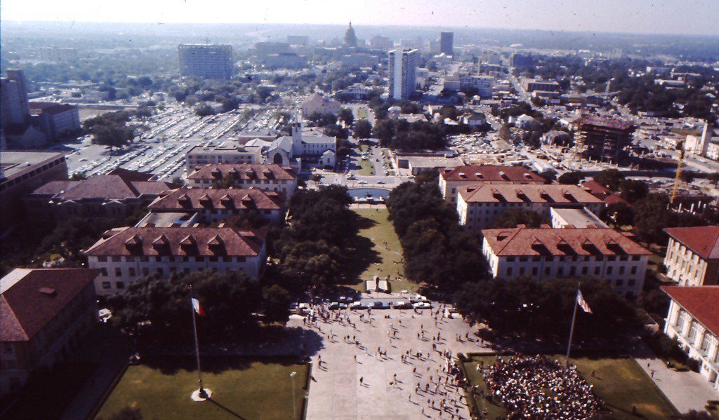
The Texas State Capitol was still the tallest building in Austin, and would be for another decade.

Other than the Capitol and UT Tower, there were no other buildings over 200 feet. Austin wouldn't see another building over 200 feet until 3 years later with the construction of the Westgate Tower which became Austin's tallest residential building. Austin also only had 17 high rises when this photo was taken. Since then more than 200 more have been built or are under construction.

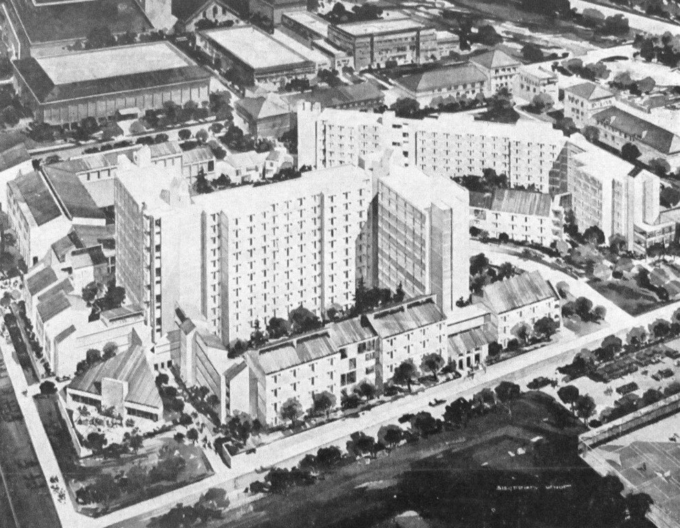
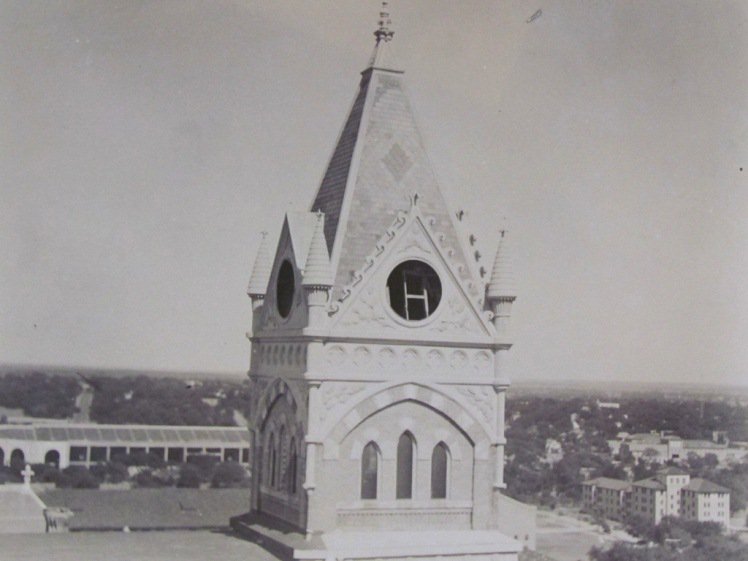
There were only two high rises on the UT Campus, and the Memorial Stadium (it had yet to be named for Darrel K. Royal who was the head coach that year, hadn't been expanded either.

In the lower right of the photo, there's a rectangular shaped building under construction with a red tower crane. That's the J.J. Pickle Federal Building. President Lyndon Johnson had an office in the building even after he became president. It was his office whenever he was visiting home in Texas.

I-35 through downtown was only 2 years old here, and the upper deck north of downtown where I-35 splits hadn't been started yet, and wouldn't be completed for another decade.

The old red bricked 1915 Brackenridge Hospital building is visible here to the right near I-35. Brackenridge expanded in the 60s through the 70s with a new tower, but the 1915 building was also expanded until it was demolished in 1984. Brackenridge Hospital was the oldest publically owned hospital in Texas. It was founded in 1884 and closed completely in 2017 after the University of Texas built a medical school across the street that replaced it.


Photo by Dave - https://www.flickr.com/photos/pgaven...80155/sizes/h/

Aerial view looking east/northeast. The area between the UT Campus and the Capitol was still all lowrise and still had its original single family homes. Through the 70s and 80s that area was paved over with acres of parking and bulky state office midrises.


Photo by Dave - https://www.flickr.com/photos/pgaven...71135/sizes/h/

Looking east/northeast over downtown and the river, sans the Hyatt Regency and Austin American-Statesman along the shore. This was at least a couple of years before Austin had any high rises near the river.


Photo by Dave - https://www.flickr.com/photos/pgaven...75844/sizes/h/

183/Montopolis Bridge in Southeast Austin.


Photo by Dave - https://www.flickr.com/photos/pgaven...89801/sizes/h/


Photo by Dave - https://www.flickr.com/photos/pgaven...51927/sizes/h/


Photo by Dave - https://www.flickr.com/photos/pgaven...39032/sizes/h/

The Triangle!


https://www.flickr.com/photos/pgaven...46361/sizes/h/
Photo by Dave -

Quote:
Allandale, looking WSW.
That's Lamar Jr High bottom left. Allandale/Koenig/2222/w/e/ cuts through the middle. (Early 1964)

Photo by Dave - https://www.flickr.com/photos/pgaven...42754/sizes/h/

Quote:
Allandale again (we lived there). Burnet Drive In on the left (The marqee is still there today.) Great Northern Blvd, the railroad track, and Balcones Dr. along the right side. Way before Mopac. (Early 1964)

Photo by Dave - https://www.flickr.com/photos/pgaven...47565/sizes/h/


Photo by Dave - https://www.flickr.com/photos/pgaven...35294/sizes/h/

Photo from 1962.


Photo by Dave - https://www.flickr.com/photos/pgaven...91198/sizes/h/
__________________
My girlfriend has a poodle named Kevin.
Reply With Quote
     
     
  #850  
Old Posted Jun 25, 2018, 10:46 PM
KevinFromTexas's Avatar
KevinFromTexas KevinFromTexas is offline
Meh
 
Join Date: Jul 2001
Location: Austin,TX<-->Dripping Springs,TX<-->Birmingham, AL<-->Warm Springs,GA
Posts: 57,205
Bonus - can you guess what city this is?


Photo by Dave - https://www.flickr.com/photos/pgaven...46581/sizes/h/
__________________
My girlfriend has a poodle named Kevin.
Reply With Quote
     
     
  #851  
Old Posted Jun 25, 2018, 11:21 PM
wwmiv wwmiv is offline
Registered User
 
Join Date: Sep 2009
Location: Austin -> San Antonio -> Columbia -> San Antonio -> Chicago -> Austin -> Denver -> Austin
Posts: 5,710
Dallas in the 1960s?
__________________
Houston: 2.4m (+3.9%) + MSA suburbs: 5.4m (+12%) + CSA exurbs: 200k (+5%)
Dallas: 1.3m (+2%) / FtW: 1.0m (+10%) + suburbs: 6.4m (9%) + exurbs: 566k (+9%)
San Antonio: 1.5m (+6%) + MSA suburbs: 1.2m (+10%) + CSA exurbs: 82k (+3%)
Austin: 994k (+3%) + MSA suburbs: 1.6m (+18%)
Texas (whole): 31.29m (+7%) / Texas (balance): 8.6m (+3%)
Reply With Quote
     
     
  #852  
Old Posted Jun 25, 2018, 11:29 PM
KevinFromTexas's Avatar
KevinFromTexas KevinFromTexas is offline
Meh
 
Join Date: Jul 2001
Location: Austin,TX<-->Dripping Springs,TX<-->Birmingham, AL<-->Warm Springs,GA
Posts: 57,205
Yep.
__________________
My girlfriend has a poodle named Kevin.
Reply With Quote
     
     
  #853  
Old Posted Jul 4, 2018, 6:09 AM
KevinFromTexas's Avatar
KevinFromTexas KevinFromTexas is offline
Meh
 
Join Date: Jul 2001
Location: Austin,TX<-->Dripping Springs,TX<-->Birmingham, AL<-->Warm Springs,GA
Posts: 57,205
__________________
My girlfriend has a poodle named Kevin.
Reply With Quote
     
     
  #854  
Old Posted Jul 5, 2018, 3:36 AM
hookem hookem is offline
Registered User
 
Join Date: Apr 2007
Posts: 1,565
Quote:
Originally Posted by KevinFromTexas View Post
All of these photos were taken in late 1964. Photo credit goes to Dave - https://www.flickr.com/photos/pgavenda/

-


Photo by Dave - https://www.flickr.com/photos/pgaven...47565/sizes/h/
The lack of trees in that shot of Allandale between Shoal Creek Blvd and Great Northern is striking. It looks like the developer didn't plant any. The entire urban forest there now must have all been self-planted by the homeowners. Hard to believe at the time this was the most basic, cookie-cutter and probably downright cheap homes, being next to a railroad track and a quarry.

How it looks now in google maps - https://goo.gl/maps/NLUu9Kd5DgB2
Reply With Quote
     
     
  #855  
Old Posted Jul 5, 2018, 5:54 PM
jg6544 jg6544 is offline
Registered User
 
Join Date: Feb 2011
Posts: 1,113
The photos of Austin are of the city in which I lived for a time and which I still remember with so much affection.
Reply With Quote
     
     
  #856  
Old Posted Jul 5, 2018, 8:19 PM
austlar1 austlar1 is offline
Registered User
 
Join Date: May 2007
Location: Austin
Posts: 3,503
Kevin, the bonus picture is an aerial of Dallas taken sometime in the early 1960s possibly. The blueish tall rectangular building is the Southland Life Buidling. The smaller Sheraton Dallas is adjacent. The darker tower with the spire is the Republic National Bank. The State Fair grounds and the Cotton Bowl are also visible below and to the left of downtown. Looks like they are still working on IH 20 (now known as IH 30) headed into town from the east. The view is from the far east side of Dallas.
Reply With Quote
     
     
  #857  
Old Posted Jul 6, 2018, 2:18 AM
Armybrat Armybrat is offline
Registered User
 
Join Date: Aug 2010
Posts: 772
The State Fair grounds are clearly visible too.
Reply With Quote
     
     
  #858  
Old Posted Jul 6, 2018, 5:59 AM
KevinFromTexas's Avatar
KevinFromTexas KevinFromTexas is offline
Meh
 
Join Date: Jul 2001
Location: Austin,TX<-->Dripping Springs,TX<-->Birmingham, AL<-->Warm Springs,GA
Posts: 57,205
Quote:
Originally Posted by hookem View Post
The lack of trees in that shot of Allandale between Shoal Creek Blvd and Great Northern is striking. It looks like the developer didn't plant any. The entire urban forest there now must have all been self-planted by the homeowners. Hard to believe at the time this was the most basic, cookie-cutter and probably downright cheap homes, being next to a railroad track and a quarry.

How it looks now in google maps - https://goo.gl/maps/NLUu9Kd5DgB2
Our neighborhood was the same way. Except for the oak trees, there were no other trees in the neighborhood. My family moved to this neighborhood in the mid-60s, and there weren't any. It's kind of a shock to look at that historic satellite photo website I mentioned in the sports thread and see my neighborhood devoid of trees. Residents planted trees, but the birds and squirrels have also planted along fence lines and utility lines. Except for a palm tree that my dad planted in 1991, we haven't planted a single tree in the yard bigger than 8 feet tall. All the others were planted by the animals.
__________________
My girlfriend has a poodle named Kevin.
Reply With Quote
     
     
  #859  
Old Posted Jul 9, 2018, 6:51 AM
drummer drummer is offline
World Traveler
 
Join Date: Jan 2015
Location: Austin metro area
Posts: 4,733
Those pesky squirrels are good for something after all...
Reply With Quote
     
     
  #860  
Old Posted Jul 9, 2018, 5:33 PM
jg6544 jg6544 is offline
Registered User
 
Join Date: Feb 2011
Posts: 1,113
Quote:
Originally Posted by hookem View Post
The lack of trees in that shot of Allandale between Shoal Creek Blvd and Great Northern is striking. It looks like the developer didn't plant any. The entire urban forest there now must have all been self-planted by the homeowners. Hard to believe at the time this was the most basic, cookie-cutter and probably downright cheap homes, being next to a railroad track and a quarry.

How it looks now in google maps - https://goo.gl/maps/NLUu9Kd5DgB2
In those days, developers just scraped a tract of all vegetation, leveled it, poured concrete slabs to build on and started throwing up houses; like the song, "little boxes on the hillside, little boxes made of ticky-tacky."
Reply With Quote
     
     
This discussion thread continues

Use the page links to the lower-right to go to the next page for additional posts
 
 
Reply

Go Back   SkyscraperPage Forum > Regional Sections > United States > Texas & Southcentral > Austin
Forum Jump


Forum Jump


All times are GMT. The time now is 6:11 PM.

     
SkyscraperPage.com - Privacy Statement - Top

Powered by vBulletin® Version 3.8.7
Copyright ©2000 - 2026, vBulletin Solutions, Inc.