HomeDiagramsDatabaseMapsForum About
     

Go Back   SkyscraperPage Forum > Regional Sections > Canada > Ontario > Hamilton > Transportation & Infrastructure


Reply

 
Thread Tools Display Modes
     
     
  #661  
Old Posted Oct 2, 2008, 9:55 PM
SteelTown's Avatar
SteelTown SteelTown is offline
It's Hammer Time
 
Join Date: Mar 2004
Location: Hamilton
Posts: 20,364
It's likely LRT will still use James Mt access until it gets too steep and have a tunnel. I doubt it'll be a complete tunnel from the base of the Escarpment to the top, likely halfway than a tunnel.
Reply With Quote
     
     
  #662  
Old Posted Oct 2, 2008, 10:13 PM
DC83 DC83 is offline
Closed account
 
Join Date: Sep 2006
Posts: 2,430
That $100 Million is for the tunnel alone! That doesn't include the price to dig out under the James St TH&B bridge. Not to mention definate over-runs that is always associated with boaring (Hi, Big Dig).

So $100 was a cost that Public Works threw out there back in May. Pretty much pulled it out of their butts. So let's say it's acually double, $200 Million incl. James St grading under the bridge + tunnel costs.
The project (both lines) was estimated to be $1.8 Billion in May '08. So if We give people a $1 Billion million pricetag (for both lines) rather a $1.2 Billion price tag, I can guarantee (esp in THIS City) we'd choose the cheaper... it's Hamilton, "...we're not a wealthy community"
Reply With Quote
     
     
  #663  
Old Posted Oct 3, 2008, 12:58 AM
raisethehammer raisethehammer is offline
Closed account
 
Join Date: May 2005
Posts: 6,054
Quote:
Originally Posted by DC83 View Post
I don't really understand where this additional 6 mins is coming from? How can even know what the times would be at this point?
If you had an LRT-ONLY Hughson between Wilson & Hunter, there would be no cars to compete with like on James (and we ALL know City Staff would NEVER shut James for LRT, it will most def be mixed traffic/lrt).
Then stop at TH&B-area, then dedicated lanes from Hunter/Hughson along Hunter to Clairmont, Dedicated Lanes along Clairmont including an exclusive right of way to West 5th via that lil bypass which would be LRT-only!

With these dedicated lanes alone the trip should be quicker than battling Cars & Peds on James. Mix-LRT/Regular Traffic along Jamesville would be good for that area though, and Hughson is residential down there, so that's why I left LRT on James in that part.
using James would be easy IMO. start routing ALL buses on John and LRT on James. The curb lane northbound only has a few parking spots and southbound nobody drives in the curb lane because cabs, delivery trucks and buses are always sitting there.
I think it's totally worth $100 mil to service the GO Station, James South, Durand, Corktown and St Joes. Plus putting all local buses 2-way on John would be great for that street and for the bus system.
Reply With Quote
     
     
  #664  
Old Posted Oct 3, 2008, 12:59 AM
raisethehammer raisethehammer is offline
Closed account
 
Join Date: May 2005
Posts: 6,054
Quote:
Originally Posted by DC83 View Post
That $100 Million is for the tunnel alone! That doesn't include the price to dig out under the James St TH&B bridge. Not to mention definate over-runs that is always associated with boaring (Hi, Big Dig).

So $100 was a cost that Public Works threw out there back in May. Pretty much pulled it out of their butts. So let's say it's acually double, $200 Million incl. James St grading under the bridge + tunnel costs.
The project (both lines) was estimated to be $1.8 Billion in May '08. So if We give people a $1 Billion million pricetag (for both lines) rather a $1.2 Billion price tag, I can guarantee (esp in THIS City) we'd choose the cheaper... it's Hamilton, "...we're not a wealthy community"
I'd suggest we just go with their numbers instead of playing a guessing game as to what they might really be.
They've been doing a bang-up job in prepping for this plan. Let's assume they know what they're talking about.
They have to tunnel. It's too steep to run on the street as far as I know.
Reply With Quote
     
     
  #665  
Old Posted Oct 3, 2008, 1:07 AM
go_leafs_go02 go_leafs_go02 is offline
Registered User
 
Join Date: Dec 2007
Location: London, ON
Posts: 2,406
Quote:
Originally Posted by raisethehammer View Post
using James would be easy IMO. start routing ALL buses on John and LRT on James. The curb lane northbound only has a few parking spots and southbound nobody drives in the curb lane because cabs, delivery trucks and buses are always sitting there.
I think it's totally worth $100 mil to service the GO Station, James South, Durand, Corktown and St Joes. Plus putting all local buses 2-way on John would be great for that street and for the bus system.
Do you really think that all the buses will be kept the same. do you think the HSR really will run the 21, 25, 26, 27, 33, 34, 35 bus routes up and down the mountain within 2 km the A-Line if there is a rapid transit connection with a higher capacity?

Let's see with a system map. Let's make Mohawk College - Fennell the Central Hub.

The 34 - Upper Paradise (would have to drive down Fennell Ave from Garth) DISTANCE: 1.00 km

The 33 - Sanatorium, 35 - College.
DISTANCE: 0.00 km (already go right by Mohawk College)

The 21 - Upper Kenilworth
DISTANCE: 0.21 km (From Fennell & West 5th to the College)

All Jolley Cut Access buses:
DISTANCE: 1.77 km (From Concession St. & Upper Wellington)
And you would rework I'm sure several routes to connect through Fennell instead of Concession

I really hope that we see a major elimination of up and down the mountain buses and adding an extra transfer onto someone trip. If you have 5 minutes headways between Mohawk College and downtown, that transfer is easy and simple to make.

Coming up the mountain. I would hope there will be a nice, indoor transit waiting area at Mohawk College where route schedules and timing are worked into a great efficient manner. Beats the crap out of Gore Park, where I don't even think there is a SINGLE bus shelter there for passenger protection.

Reply With Quote
     
     
  #666  
Old Posted Oct 3, 2008, 12:07 PM
ryan_mcgreal's Avatar
ryan_mcgreal ryan_mcgreal is offline
Raising the Hammer
 
Join Date: Apr 2008
Location: Hamilton
Posts: 527
Quote:
Originally Posted by go_leafs_go02 View Post
Do you really think that all the buses will be kept the same.
Public Works staff have stated clearly that if LRT is built, the entire transit network will have be be reconfigured.
Reply With Quote
     
     
  #667  
Old Posted Oct 3, 2008, 1:02 PM
raisethehammer raisethehammer is offline
Closed account
 
Join Date: May 2005
Posts: 6,054
buses won't be kept the same, but there will still be local bus service.
I assume many of the east mountain buses will still come downtown via the jolley cut. my suggestion is they can use john st, go west on king, south through macnab terminal and east on main back to john and go back up that way instead of continuing with this stupid one-way bus system we have on two-way streets.
Reply With Quote
     
     
  #668  
Old Posted Oct 3, 2008, 1:11 PM
realcity's Avatar
realcity realcity is offline
Bruatalism gets no respec
 
Join Date: Jun 2003
Location: Williamsville NY
Posts: 4,059
oops
__________________
Height restrictions and Set-backs are for Nimbys and the suburbs.
Reply With Quote
     
     
  #669  
Old Posted Oct 3, 2008, 4:58 PM
omro's Avatar
omro omro is offline
Is now in Hamilton, eh
 
Join Date: Dec 2007
Location: Hamilton
Posts: 1,127
The McNab Terminal is going to service both lines of the east/west LRT service or just one?
Reply With Quote
     
     
  #670  
Old Posted Oct 3, 2008, 5:07 PM
SteelTown's Avatar
SteelTown SteelTown is offline
It's Hammer Time
 
Join Date: Mar 2004
Location: Hamilton
Posts: 20,364
Both as it is sandwiched between King and Main.
Reply With Quote
     
     
  #671  
Old Posted Oct 3, 2008, 5:15 PM
go_leafs_go02 go_leafs_go02 is offline
Registered User
 
Join Date: Dec 2007
Location: London, ON
Posts: 2,406
You really think the A-Line is gonna jump over a block or two from either Hughson or James St?

The straighter north-south path we get, the better this line will be. It's gotta be a efficient as possible. That's why I encourage tunneling directly up James St. Too bad Mohawk College isn't along Upper James, but in my books, that is the only shift of north south routing that should be made.

EDIT: Nevermind, I realize a walkway connecting from James over to MacNab would work well. I just don't want the tracks routed onto King, over to MacNab, and back over to James or whatever.
Reply With Quote
     
     
  #672  
Old Posted Oct 3, 2008, 5:18 PM
omro's Avatar
omro omro is offline
Is now in Hamilton, eh
 
Join Date: Dec 2007
Location: Hamilton
Posts: 1,127
Quote:
Originally Posted by SteelTown View Post
Both as it is sandwiched between King and Main.
Assuming the LRT is on both Main and King, which I hope it will not be.

That will dictate that the LRT is on the north side of Main and possibly that south side of King, correct? If so, will this have implications further down the roads if the LRT is tied into these sides?

So the design for the hub is going to be updateable to allow for an LRT stop/station to be bolted on or will the design include it from day one of construction?

Also, will this hub service the north/south LRT lines also?
Reply With Quote
     
     
  #673  
Old Posted Oct 3, 2008, 5:26 PM
omro's Avatar
omro omro is offline
Is now in Hamilton, eh
 
Join Date: Dec 2007
Location: Hamilton
Posts: 1,127
Quote:
Originally Posted by go_leafs_go02 View Post
Too bad Mohawk College isn't along Upper James, but in my books, that is the only shift of north south routing that should be made.
There's nothing to say that spur lines off the A and B lines could happen in the final design or in the future. Many London Underground lines have two or more start and end points, with every other train going to a different destination, but sharing the bulk of the route.
Reply With Quote
     
     
  #674  
Old Posted Oct 3, 2008, 5:33 PM
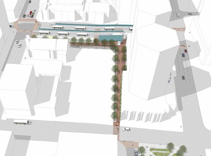
SteelTown's Avatar
SteelTown SteelTown is offline
It's Hammer Time
 
Join Date: Mar 2004
Location: Hamilton
Posts: 20,364


That's the plan for the MacNab terminal. You can see a walkway from the terminal to James St, which A-Line will pass by. MacNab is also sandwiched between King and Main for B-Line.

With the white space you see, currently a parking lot, when funding is available from Metrolinx the city would like to purchase the lot and expand the MacNab terminal, making it a much bigger terminal.
Reply With Quote
     
     
  #675  
Old Posted Oct 3, 2008, 6:05 PM
omro's Avatar
omro omro is offline
Is now in Hamilton, eh
 
Join Date: Dec 2007
Location: Hamilton
Posts: 1,127
When our council demolished our Bus Station and built a new one, we thought we were going to get something similar to that, just stands on street, but instead we actually got a rather nice building out of it. It's much nicer than what was there!

Reply With Quote
     
     
  #676  
Old Posted Oct 3, 2008, 8:14 PM
raisethehammer raisethehammer is offline
Closed account
 
Join Date: May 2005
Posts: 6,054
we're supposed to be getting a glass terminal building too...won't be as nice as that, but it's not really visible from that above rendering.
Also, the 'stands on the street' are actually covers over the entire length of the walkway, not individual bus shelters.
If they design it properly, it could be really great.
Reply With Quote
     
     
  #677  
Old Posted Oct 4, 2008, 12:36 AM
SteelTown's Avatar
SteelTown SteelTown is offline
It's Hammer Time
 
Join Date: Mar 2004
Location: Hamilton
Posts: 20,364
Hamilton ready to move on LRT

October 03, 2008
The Hamilton Spectator

It’s not definite yet, but plans for a light-rail transit system in Hamilton are barrelling full steam ahead.

City staff have been studying what a system would mean and how it could be put into place.

Here’s a snapshot of the situation so far, with new staff suggestions on how the city could move forward on light-rail transit and what rapid transit has meant for other cities.

The plan so far
Develop light-rail transit east to west along King and Main and a north-south route up the Mountain. The Mountain line could use either James Mountain Road or the Claremont Access.

Winding up
To use the Claremont Access, the route would run from James Street to Main, then along Wellington and up the Claremont.
The route would avoid constructing a tunnel on James Mountain Road, but would also miss key spots such as the GO Station. It would cost $100 million less to climb the Claremont.
“In the long run … you’re always better off if you build around hubs or around places of employment,” said Pavlos Kanaroglou, director of the McMaster Institute for Transportation and Logistics.

Timeline
City staff project construction on the east-west line could begin in spring 2011. The city is waiting for the final word from regional transportation body Metrolinx as to where the project stands on the priority list.

In the median
The idea of a “median transitway” concept has been proposed for the north-south line.
That means exterior lanes of a road would be used for traffic, while the interior would be used for rapid transit, with the median as the station.

Economic benefits
- In Dallas, Texas, and St. Louis, Mo., property values near rapid transit stations rose by 32 per cent.
- In Portland, Ore., there’s been more than $2 billion US in development surrounding the downtown stations.
- In Santa Clara, Calif., office space sold for two to five cents more per square foot if it was within half a kilometre of an light-rail transit station.
Reply With Quote
     
     
  #678  
Old Posted Oct 4, 2008, 12:45 AM
raisethehammer raisethehammer is offline
Closed account
 
Join Date: May 2005
Posts: 6,054
so, where does this tunnel go? from James St to Mohawk College?
That would be sweet.
I remember in Portland they had to construct a portion of their LRT underground in the west hills just west of downtown. I think they have the deepest 'subway' station in the US. You have to take an elevator out.
Reply With Quote
     
     
  #679  
Old Posted Oct 4, 2008, 3:11 AM
SteelTown's Avatar
SteelTown SteelTown is offline
It's Hammer Time
 
Join Date: Mar 2004
Location: Hamilton
Posts: 20,364
Reply With Quote
     
     
  #680  
Old Posted Oct 4, 2008, 9:13 AM
omro's Avatar
omro omro is offline
Is now in Hamilton, eh
 
Join Date: Dec 2007
Location: Hamilton
Posts: 1,127
Quote:
Originally Posted by SteelTown View Post
Cool video, up to the simulation. That's an eight lane wide - three lanes in each direction for cars and two lanes wide for one LRT. Didn't think there were any roads like that in Hamilton. But that's merely a nitpick. Great to see it getting so much support!!
Reply With Quote
     
     
This discussion thread continues

Use the page links to the lower-right to go to the next page for additional posts
 
 
Reply

Go Back   SkyscraperPage Forum > Regional Sections > Canada > Ontario > Hamilton > Transportation & Infrastructure
Forum Jump


Forum Jump


All times are GMT. The time now is 1:08 AM.


Powered by vBulletin® Version 3.8.7
Copyright ©2000 - 2026, vBulletin Solutions, Inc.