Quote:
Originally Posted by Crawford

London, relative to Toronto, has been growing slowly.
In 1840, there were already 2 million in Greater London (which isn't metropolitan London). Toronto at the time was a fringe frontier settlement.
At the close of WW2, there were 8 million in Greater London, and 1 million in Toronto metro (again, not apples-apples; there were probably a couple of million extra in London's commuter belt).
Presently, there are around 9 million in Greater London, maybe 14 million in the metro, and maybe 7-8 million in Toronto metro. So Toronto has had much faster growth over the long-term.
|
I don’t think it can be disputed that there has been strong growth in and around Toronto, particularly in the post-WWII era, my point is that the actual rate of growth and alluded decline of London is not an accurate assessment.
Taking a step back, I think a lot of the issues involving discussions with London (post-WWII) and subsequent comparisons is that it has developed in a completely different way to the majority of its international peers. Metro areas are for all intents and purposes a measure of sprawl so when restrictions are in place, that limits comparisons. Hamilton might be connected to the GTA but lacks the connectivity and interaction of say Cambridge or Brighton which are significantly detached from the urban area of London.
Going back 120 years, there was already movement to alleviate pressure on London with the emergence of the Garden Cities, like Letchworth and Welwyn. That then sparked a transformation of the then sleepy market towns into some of the world’s first commuter towns that radiated out from London but were not connected to the urban area.
The last point is important because as adoption of the automobile began to take off, London was starting to replicate the same sprawling tendencies of New York and hundreds of other cities at that point in time. The response was the
Green Belt Act 1938. London’s – the Metropolitan Green Belt, which hugs around the city and its hinterland and covers an area around 3x that of London itself – essentially put a stop to suburban sprawl. Which is why when you hit the edge of London the age of the dwellings is from the WWII era as the below map demonstrates.
 Source: Consumer Data Research Centre, https://maps.cdrc.ac.uk/#/metrics/dwellingage
Following the conclusion of WWII, the
New Towns Act 1946 came into force to rehouse Londoners displaced from their Blitzed homes and places of work. New towns including Stevenage (1946), Crawley, Harlow and Hemel Hempstead (1947), Hatfield (1948), Basildon and Bracknell (1949) emerged around London. A further outer ring of new towns emerged in the 1960’s including Milton Keynes and Peterborough (1967) and Northampton (1968). The Victorians built the railways, but it was the post-WWII upgrades to connect the New Towns, Garden Cities and booming old market towns and villages, that laid the foundations for the modern-day commuter network.
Whilst this was going on, the WWII destroyed (and those deemed at the time as inadequate or unwanted) residential parts of London were redeveloped, but at a much lower density. The creation of the Location of Offices Bureau and the
Control of Offices and Industrial Development Act 1965 by central government encouraged relocation of jobs away from London; between 1963-79 160,000 office and 55,000 civil service jobs relocated out of London. To curtail development in London further, substantial restrictions on office developments
above 5,000 sq ft were implemented which is one reason for so few skyscrapers emerged in London after WWII.
My hometown – a quaint market town located in a rural district north of London – demonstrates the efforts to de-populating London quite well; in the 20-years after WWII, its population doubled, by 2018 the population had expanded 3x its pre-WWII level. This situation was replicated across the South East and East regions that encompass London.
In the 1980’s it was recognised that simply displacing the population and artificial handicaps on economic activity were inefficient and counterproductive. Without those restrictions (albeit with the Green Belt still in place), London’s growth resumed.
Quote:
Originally Posted by Crawford
And looking forward, Canada is one of the most pro-immigration nations on the planet, while the UK isn't. Given that immigration is nowadays almost entirely determinitive of metropolitan growth, it's reasonable to assume that Toronto will have somewhat more robust growth in the coming decades.
|
There certainly are anti-immigration elements and immigration was a part of the Brexit referendum but it would be incorrect to label the country anti-immigrant.
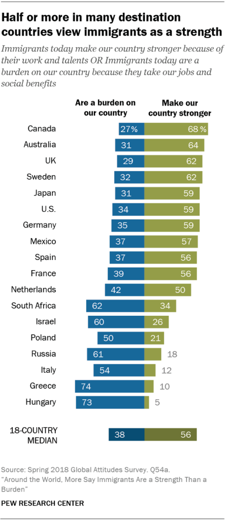 Source: Pew Research: https://www.pewresearch.org/global/2...than-a-burden/
Quote:
Originally Posted by Mister F
Not really. The majority of the population of Australia and Canada are concentrated into small areas. Most Canadians, for example, live in the Windsor-Quebec corridor, which has around 100 people/sq km. That's still a lot less than England and there's room for a lot more people, but the existing density is comparable to countries like France and Spain.
|
France and Spain also have large areas of land that limit their habitable land, the Alps, Pyrenees, Cantabrians, Sierra Nevada, Massifs, etc… Even then, the contrast in the level of infrastructure between France and Spain and that of the Windsor-Quebec corridor is stark.
Which of course comes back to a previous point I brought up, where is the infrastructure to support this future growth? The Windsor-Quebec Corridor doesn’t have an equivalent to the West Coast Main Line.


 Prev
Prev


 Linear Mode
