HomeDiagramsDatabaseMapsForum About
     

Go Back   SkyscraperPage Forum > Regional Sections > United States > Texas & Southcentral > Austin


Reply

 
Thread Tools Display Modes


  #1  
Old Posted Sep 17, 2009, 3:45 AM
adtobias adtobias is offline
Registered User
 
Join Date: Jul 2007
Posts: 285
Look at the traffic or lack of.
Reply With Quote
     
     
  #2  
Old Posted Sep 24, 2009, 1:53 AM
KevinFromTexas's Avatar
KevinFromTexas KevinFromTexas is offline
Meh
 
Join Date: Jul 2001
Location: Austin,TX<-->Dripping Springs,TX<-->Birmingham, AL<-->Warm Springs,GA
Posts: 57,205
I read once the river was a mile wide in that flood.
__________________
My girlfriend has a poodle named Kevin.
Reply With Quote
     
     
  #3  
Old Posted Sep 24, 2009, 3:35 AM
The ATX's Avatar
The ATX The ATX is offline
Moderator
 
Join Date: May 2006
Location: Right here, right now
Posts: 12,729
In that last picture you can see why Sometimes Island pops up during droughts.
__________________
Follow The ATX on X:
https://x.com/TheATX1

Things will be great when you're downtown.
Reply With Quote
     
     
  #4  
Old Posted Sep 24, 2009, 10:33 AM
arbeiter's Avatar
arbeiter arbeiter is offline
passion for patterns
 
Join Date: Apr 2004
Location: San Francisco
Posts: 10,336
I have an old map of Austin from about 1920 somewhere I wanted to include, but I can't find it. It had a few interesting place markers on it.

It called Lake Austin "Lake McDonald" and referred to Westlake, at least what might be called Upper Westlake today (i.e. the area near Davenport Ranch shopping center that is in Austin proper) as Chatauqua! And it also referred to the area directly north of Mount Bonnell (probably the area between 2222 and Cat Mountain) as Spicewood Springs. I have always thought that Spicewood Springs was kind of a fake place name, since it is seemingly meant to describe a non-existent body of water for an area over 5 miles long.
__________________
you should know that I'm womanly wise
my website/blog. or, my flickr site.
Reply With Quote
     
     
  #5  
Old Posted Sep 24, 2009, 2:41 PM
Downtown_Austin's Avatar
Downtown_Austin Downtown_Austin is offline
Registered User
 
Join Date: Nov 2008
Location: Austin, Texas
Posts: 398
Quote:
Originally Posted by arbeiter View Post
I have an old map of Austin from about 1920 somewhere I wanted to include, but I can't find it. It had a few interesting place markers on it.

It called Lake Austin "Lake McDonald" and referred to Westlake, at least what might be called Upper Westlake today (i.e. the area near Davenport Ranch shopping center that is in Austin proper) as Chatauqua! And it also referred to the area directly north of Mount Bonnell (probably the area between 2222 and Cat Mountain) as Spicewood Springs. I have always thought that Spicewood Springs was kind of a fake place name, since it is seemingly meant to describe a non-existent body of water for an area over 5 miles long.
wow. i hope you can find that!
Reply With Quote
     
     
  #6  
Old Posted Sep 24, 2009, 9:37 PM
LoneStarMike's Avatar
LoneStarMike LoneStarMike is offline
Registered User
 
Join Date: Aug 2006
Location: Austin -> Tyler, TX
Posts: 2,317
Quote:
Originally Posted by arbeiter View Post
I have an old map of Austin from about 1920 somewhere I wanted to include, but I can't find it. It had a few interesting place markers on it.

It called Lake Austin "Lake McDonald" and referred to Westlake, at least what might be called Upper Westlake today (i.e. the area near Davenport Ranch shopping center that is in Austin proper) as Chatauqua!
Here's some info from texasescapes.com

http://www.texasescapes.com/AustinTe...LakeAustin.htm

Riverboats were very popular at the turn of the century and made regular excursions to what was then known as Lake McDonald. A paddleboat called the Ben Hur used to take people up to Camp Chautauqua for parties before the Colorado River was dammed.

Here is a postcard of the Ben Hur from http://www.austinpostcard.com


The original dam which formed Lake McDonald was called the Austin Dam. The press often referred to it as The Great Dam or The Great Granite Dam. It gave way during a flash flood on August 7, 1900 and its rubble formed what is now Red Bud Isle. Many of the dam's original granite blocks are in the parking lot today.

The rubble of the dam –large granite blocks, rubble infill and chunks of concrete– formed Red Bud Isle in a matter of hours. Over the years, silt, trash dumping, construction waste and lots of new greenery would fill in the island and make it seem like it had always been there.

Source

A couple of postcards of the dam from austinpostcard.com


Postcard of the dam after the flood


Quote:
Originally Posted by arbeiter View Post
And it also referred to the area directly north of Mount Bonnell (probably the area between 2222 and Cat Mountain) as Spicewood Springs. I have always thought that Spicewood Springs was kind of a fake place name, since it is seemingly meant to describe a non-existent body of water for an area over 5 miles long.
More info from texasescapes.com:

What is now Lake Austin was once a thriving area of early settlements. The water has since covered up several springs. Power House Springs was discovered during the construction of one of the dams in 1893. Bee Springs, just above Tom Miller Dam, is under the convergence of Bee Creek and Lake Austin. Mormon Springs was the site of a Mormon settlement in 1846 and was also used for a gristmill. Mount Bonnell Springs is a cluster of water sources near the mountain. Santa Monica Springs was also a popular watering hole and many artifacts were found there

I'll bet Spicewood Springs was another spring that was covered up when Lake Austin was formed.
Reply With Quote
     
     
  #7  
Old Posted Sep 24, 2009, 10:47 PM
hookem hookem is offline
Registered User
 
Join Date: Apr 2007
Posts: 1,565
Quote:
Originally Posted by LoneStarMike View Post
I'll bet Spicewood Springs was another spring that was covered up when Lake Austin was formed.
Perhaps another explanation (or explanations -- search this book and there 3 are or more mentions of different "Spicewood Springs"):

http://books.google.com/books?id=bvJ...ngs%22&f=false

One is described as being at the intersection of Ceberry and Spicewood Springs Rd (p 434), which I find interesting... I used to live in that area and don't remember anything like a spring. But it would be fun to look again!

Another section (p102) says that Krause Springs was formerly known as Spicewood Springs and served as the water supply for Spicewood, TX.

Yet another section refers to Spicewood Springs as being about 8 miles north of Salado.
Reply With Quote
     
     
  #8  
Old Posted Oct 3, 2009, 4:23 AM
Dan Denson Dan Denson is offline
Closed account
 
Join Date: Sep 2008
Location: Austin now, Houston soon
Posts: 1,578
Quote:
Originally Posted by hookem View Post
Perhaps another explanation (or explanations -- search this book and there 3 are or more mentions of different "Spicewood Springs"):

http://books.google.com/books?id=bvJ...ngs%22&f=false

One is described as being at the intersection of Ceberry and Spicewood Springs Rd (p 434), which I find interesting... I used to live in that area and don't remember anything like a spring. But it would be fun to look again!

Another section (p102) says that Krause Springs was formerly known as Spicewood Springs and served as the water supply for Spicewood, TX.

Yet another section refers to Spicewood Springs as being about 8 miles north of Salado.
In that stretch of Spicewood Springs road from Loop 360 to 183, what's the creek that the road crosses? I had always assumed that was Spicewood Springs. Maybe not, though.
Reply With Quote
     
     
  #9  
Old Posted Oct 3, 2009, 4:29 AM
Dan Denson Dan Denson is offline
Closed account
 
Join Date: Sep 2008
Location: Austin now, Houston soon
Posts: 1,578
Anyone remember a fried chicken place on the east side of 183, south of Anderson Mill Rd., in the 80s? Can't think of the name of it. Best fried chicken I've ever had. I lived out there at the time, and had lunch there often. Back then, there was no freeway; just a divided highway that was horrendously traffic-clogged. That's why I moved away from that area.
Reply With Quote
     
     
  #10  
Old Posted Oct 2, 2009, 4:06 AM
arbeiter's Avatar
arbeiter arbeiter is offline
passion for patterns
 
Join Date: Apr 2004
Location: San Francisco
Posts: 10,336
Here are a few pictures from Northwest Austin in the late 1980's:

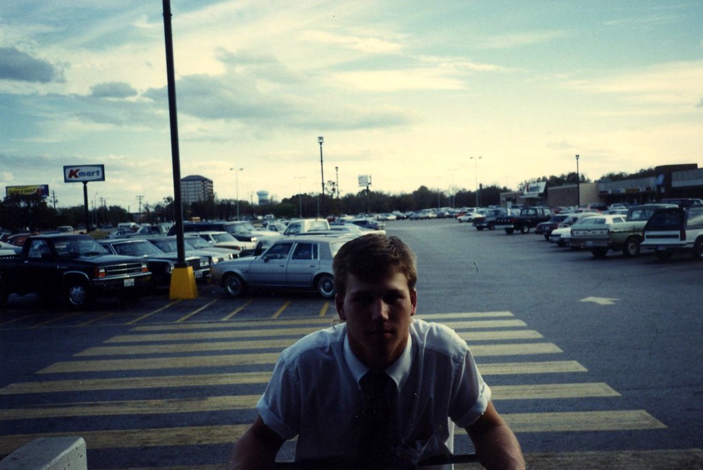
I don't know who the guy is, but this is the entrance to the Anderson Mill HEB that used to be in the Travis Square shopping center. You can see the K-mart sign, and you may notice the old "Bank of the Hills Tower" - which is now a Chase tower I believe. The trees to the back are mostly still there, but if you were to stand in this spot today, you would probably be somewhere in the middle of Lakeline Plaza (probably just past the Best Buy.) Also, if you were to face this angle today you'd see a huge highway interchange (45 and 183).


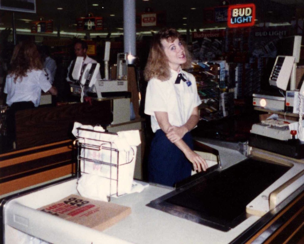
A picture from inside (not sure who the woman is). Notice the "THEBAG"s to the lower left - that was the awesome clever postmodern wording they used to put on the paper sacks but got rid of by the early 90's.


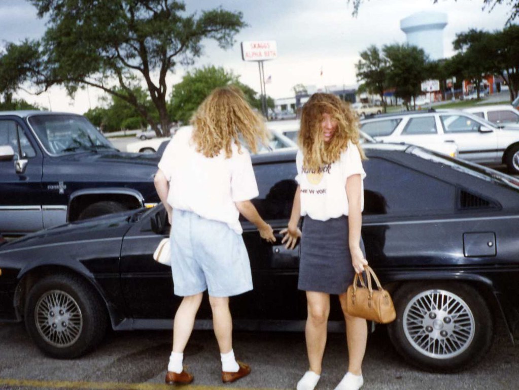
My aunt is the one opening the door to the car - her best friend is the one facing the camera. That's a 1986 Mitsubishi Cordia! This is from Anderson Mill and 183 - the water tower showing in this picture is also showing in the first picture (of the HEB where Lakeline is today.)

And check out the SKAGGS ALPHA BETA sign!

__________________
you should know that I'm womanly wise
my website/blog. or, my flickr site.
Reply With Quote
     
     
  #11  
Old Posted Oct 2, 2009, 1:56 PM
Downtown_Austin's Avatar
Downtown_Austin Downtown_Austin is offline
Registered User
 
Join Date: Nov 2008
Location: Austin, Texas
Posts: 398
Quote:
Originally Posted by arbeiter View Post
Here are a few pictures from Northwest Austin in the late 1980's:


LOVE IT! Let's get more photos like this which capture Austinites throughout the 70s and 80s.
Reply With Quote
     
     
  #12  
Old Posted Oct 2, 2009, 4:00 PM
Raining Inside Raining Inside is offline
BANNED
 
Join Date: Nov 2007
Location: ASATex Megaplex
Posts: 536
That really brings back memories. I use to date a girl that worked at that HEB. She was a stripper at the Yellow Rose prior to that and was trying to straighten up her life. It wasn't this chick though:
Reply With Quote
     
     
  #13  
Old Posted Oct 2, 2009, 9:35 AM
Mopacs's Avatar
Mopacs Mopacs is offline
Austinite
 
Join Date: Jul 2002
Location: Austin.TX.USA
Posts: 4,622
WOW! What a blast from the past! I spent much of my childhood at the old Travis Square and Skaggs.

The Skaggs became Alberston's (circa 1989), which in turn moved across the street in the late 90s. The building now houses a Lacks furniture store. Prior to relocating, I checked out the Albertson's video rental section. It was literally frozen in time, housing the same old 80s movies, in their ORIGINAL cases (circa 1985)... faded and everything.

Travis Square was quite the hangout too. Anyone remember the old 'Gary's Sub Shoppe'? For years there was a "Furr's coming soon" sign in front of the center.... which was never built.

The old HEB was located roughly where Applebee's and Linens n Things now stand. Ironically, the Linens building sits vacant today...following its corporate shutdown.
__________________
Austin.Texas.USA
Home of the 2005 National Champion Texas Longhorns
Reply With Quote
     
     
  #14  
Old Posted Oct 2, 2009, 8:09 PM
arbeiter's Avatar
arbeiter arbeiter is offline
passion for patterns
 
Join Date: Apr 2004
Location: San Francisco
Posts: 10,336
Quote:
Originally Posted by Mopacs View Post
WOW! What a blast from the past! I spent much of my childhood at the old Travis Square and Skaggs.

The Skaggs became Alberston's (circa 1989), which in turn moved across the street in the late 90s. The building now houses a Lacks furniture store. Prior to relocating, I checked out the Albertson's video rental section. It was literally frozen in time, housing the same old 80s movies, in their ORIGINAL cases (circa 1985)... faded and everything.

Travis Square was quite the hangout too. Anyone remember the old 'Gary's Sub Shoppe'? For years there was a "Furr's coming soon" sign in front of the center.... which was never built.
I remember Gary's Subs - I specifically remember our family ordering a bunch of subs for family and family friends on the day we moved from apartments off Lake Creek Parkway to a house in Anderson Mill. They were delivered on these flat pieces of cardboard wrapped in saran. It was located between the Yaring's and the HEB in the 'corner'.

Does anyone remember the Video Station rental place across the street in the unloved, perpetually empty North Fork Plaza?

I went through a bunch of photo stacks last night and found one that shows the Yaring's at Travis Square but I can't find it now!
__________________
you should know that I'm womanly wise
my website/blog. or, my flickr site.
Reply With Quote
     
     
  #15  
Old Posted Oct 3, 2009, 3:12 PM
Downtown_Austin's Avatar
Downtown_Austin Downtown_Austin is offline
Registered User
 
Join Date: Nov 2008
Location: Austin, Texas
Posts: 398
Photo of the construction of the Pennybacker bridge from Texasfreeway.com
Reply With Quote
     
     
  #16  
Old Posted Oct 16, 2009, 4:22 AM
KevinFromTexas's Avatar
KevinFromTexas KevinFromTexas is offline
Meh
 
Join Date: Jul 2001
Location: Austin,TX<-->Dripping Springs,TX<-->Birmingham, AL<-->Warm Springs,GA
Posts: 57,205
19 cent hamburgers.
__________________
My girlfriend has a poodle named Kevin.
Reply With Quote
     
     
  #17  
Old Posted Oct 16, 2009, 5:40 AM
arbeiter's Avatar
arbeiter arbeiter is offline
passion for patterns
 
Join Date: Apr 2004
Location: San Francisco
Posts: 10,336
great pictures!
__________________
you should know that I'm womanly wise
my website/blog. or, my flickr site.
Reply With Quote
     
     
  #18  
Old Posted Oct 16, 2009, 7:49 AM
LoneStarMike's Avatar
LoneStarMike LoneStarMike is offline
Registered User
 
Join Date: Aug 2006
Location: Austin -> Tyler, TX
Posts: 2,317
Thanks!

Rail & Depot photos from The Portal to Texas History (unless otherwise noted)

I. & G.N.R.R. Depot, (3rd & Congress) (early 1900's)
From austinpostcard.com


More info on the above postcard:

Quote:
The International and Great Northern Railroad was the second railroad to reach Austin. They completed the new line from Palestine to Austin in December of 1876. This depot was located at 3rd and Congress.

I & G N.R.R. Depot, Austin Texas - postmarked January 12, 1909
From austinpostcard.com


I & G N.R.R. Depot, Austin Texas - no postmark
From austinpostcard.com


H. & T.C.R.R. and M.K. & T.R.R. Depot, Austin, Texas (3rd & Congress) (early 1900's) - postmarked August 29, 1912
From austinpostcard.com


H. & T. C. Depot, Austin, Texas.- no postmark
From austinpostcard.com


H. & T.C. Depot, Austin, Texas (3rd & Congress) - no postmark
From austinpostcard.com


Photo of individuals gathered around the Freedom Train. Austin, Texas. - 1948


extra-large photo

Photo of back of train and Sam Wah cafe during during Harry Truman's Whistle Stop tour. Austin, Texas. - 1948


extra-large photo

Photo of President Harry Truman during his Whistle Stop campaign, crowd and staff of the train car. Austin, Texas - 1948


extra-large photo

Missouri-Pacific Lines - Depot Opening - exterior view - 1949 To me this looks more like a remodeled & renamed I. & G. N. R. R. Station at Congress & 3rd. Plus I don't think 1949 would be the right year because it's visible in the 1948 photos of Harry Truman's Whistle Stop Tour posted above and it looks like it was already open then.
[/b]

extra-large photo

Missouri-Pacific Lines - Depot Opening - Two men standing by railroad tracks. Tips Engine Works is in background. - 1949 This station looks like it was where the Amtrak Station is today. I recognize those buildings across from the tracks.


extra-large photo


Aerial view looking NW from about the north approach to Lamar bridge. At the lower right, RR tracks cross Lamar Blvd. - 1950


extra-large photo


I wonder when the original train station on N. Lamar was torn down, because that's definitely not the station that's there today.

March 6, 2009
Reply With Quote
     
     
  #19  
Old Posted Oct 16, 2009, 9:39 AM
LoneStarMike's Avatar
LoneStarMike LoneStarMike is offline
Registered User
 
Join Date: Aug 2006
Location: Austin -> Tyler, TX
Posts: 2,317
Airport and Aviation photos from The Portal to Texas History (unless otherwise noted)


Austin's First Municipal Airport
From Austin Treasures - Online Exhibits from the Austin History Center


More info on the above photo:

Quote:
Austin's first Municipal Airport was dedicated on October 14, 1930. The selection of the site for the facility was a much simpler process in the 1920s than it is today. After searching all of Travis County, the site selection committee, composed of Chamber of Commerce Manager Walter Long and civic leaders Max Bickler and Julian Baldwin, settled on a 190-acre cotton field. Its major attraction was proximity to the already established Austin Air Service. After receiving federal approval, City Council voted to purchase the recommended site. Council sentiment, however, favored the purchase of only 80 of the 190 available acres. Councilmember Dave Reed, perhaps more enthusiastic about the future of aviation than his colleagues, persuaded the Council to approve purchase of the entire 190 acres. An additional 150 acres on which the City held an option was included later.
"At that time the field had gravel runways and was equipped with a gasoline pump and a small office building on the northeast side. The agreement called for twenty-four hour service on the field. The major employee was Reagan B. Dickard, who was a pilot. Burck Smith was the other employee…The salaries ran on a monthly basis. The only profit was an occasional sale of a tank of gasoline. After a year's time and a $2,000 loss I resigned as manager." John D. Miller, First Airport Manager, quoted in Wings Over Austin.
Aerial View from a 1938 Directory
From Abandoned & Little Known Airfields

(The Abandoned & Little Known Airfields site has a lot of good info & numerous photos on Mueller and other airports in the Austin area, including a University Airport that was apparently owned by U.T.)


According to the above site, Braniff began the first passenger service in Austin on January 1, 1936.

Photo of a Braniff DC-4, the 1st DC-4 in Austin, Texas - 1946


extra-large photo

This next photo doesn't specifically say it was taken in Austin, but the holding partner for the photo is the Austin Public Library. I'm posting it anyway, 'cause I think it's hilarious. Check out the little boy in shorts on the left. That little outfit and pose is just too much. I was that same kid about 12 years later, only my outfit would have been a turtleneck, bell bottoms, a medallion, and one of those fringe leather suede vests.

Kids Boarding Plane. Kids wait with pilot, flight crew to board Trans-Texas Airlines - 1956


extra-large photo

According to the Abandoned & Little Known Airfield site, in 1956 the city extended Mueller's runway to 7,629' to accomodate jet traffic. The original site was expanded to 711 acres by acquiring adjoining land.

Robert Mueller Municipal Airport Terminal Under Construction
From Abandoned & Little Known Airfields


Robert Mueller Municipal Airport. Lester Palmer at dedication ceremony for new terminal - 1961
(From airportjournals.com


extra-large photo

The original "new terminal" only had a covered walkway (the airside pier) out to the planes from the central building with it's distinctive scalloped roof front. It was that way until the early 1970's.


Gate 2 - Robert Mueller Municipal Airport - 1961


extra-large photo

Customers wait in line at ticket counter at Mueller Airport - 1965


extra-large photo

Shot of customers, employees from behind the check-in counter at Mueller Airport - 1965


extra-large photo

Passengers and crew wave goodbye on the tarmac before departure at Mueller Airport - 1965


extra-large photo

Robert Mueller Municipal Airport - early 1960's
From austinpostcard.com


Control Tower - Robert Mueller Municipal Airport - early 1960's
From austinpostcard.com


While President Johnson was in office, Braniff ran 1 daily nonstop from Austin to Washington Dulles on a 727.

Robert Mueller Municipal Airport - early 1970's
From austinpostcard.com


In the early 1970's a second level was added over the airside pier and connected to the main terminal. A new sloping ramp was built connecting the main terminal with 6 upper-level gate holdrooms, all equipped with jetway loading bridges. God I remember walking up that sloping ramp to the gates when it was raining outside and seeing buckets everywhere and water stains on the ceiling towards the end. And the bluebonnets that hung upside down from the ceiling at the entrance to the ramp - does anyone remember those?

A 5-gate 'rotunda' was added to the end of the passenger pier in the early 1980s to accommodate the extra airlines that came in after dregulation in 1978.

Robert Mueller Municipal Airport - 1980's
From Abandoned & Little Known Airfields


In the mid-1980s, the city of Austin abandoned plans to construct a new terminal & parallel runway and instead began searching for a site to build a replacement airport. In the meantime, they approved a 'stopgap' bond package to allow for improvements at Mueller. Southwest, which had become the airport's largest carrier, opened its own 'unit terminal' in 1988. Known as the East Terminal, it featured 4 jetway-equipped gates & a single large departure lounge, constructed above new ticket counters & operations offices. The arrival & departure roadways were also widened & redesigned.


Aerial View - late 1990's
From Abandoned & Little Known Airfields


Aerial View in 2000 after Mueller's closure
From Abandoned & Little Known Airfields
Reply With Quote
     
     
  #20  
Old Posted Oct 16, 2009, 7:11 PM
hookem hookem is offline
Registered User
 
Join Date: Apr 2007
Posts: 1,565
The footprint of the current Amtrak station looks pretty close to the aerial shown from 1950... the awning adjacent to the tracks is gone, but the station itself might have just been remodeled. There are definitely 2 different stations depicted in the "Missouri Pacific Depot Opening," so they must have at least some of those inaccurately labeled..

Aerial from a few years ago:
http://www.bing.com/maps/default.asp...cl=1&encType=1

Birds eye of same:
http://www.bing.com/maps/default.asp...7940&encType=1

I think those two men were standing just east of where that white van is in the above aerial. You can see the old buildings (Tips Engine Works) across the tracks, as well as the concrete base that the awning must have stood over.


Quote:
Originally Posted by LoneStarMike View Post
Missouri-Pacific Lines - Depot Opening - Two men standing by railroad tracks. Tips Engine Works is in background. - 1949 This station looks like it was where the Amtrak Station is today. I recognize those buildings across from the tracks.


extra-large photo


Aerial view looking NW from about the north approach to Lamar bridge. At the lower right, RR tracks cross Lamar Blvd. - 1950


extra-large photo


I wonder when the original train station on N. Lamar was torn down, because that's definitely not the station that's there today.

March 6, 2009
Reply With Quote
     
     
This discussion thread continues

Use the page links to the lower-right to go to the next page for additional posts
 
 
Reply

Go Back   SkyscraperPage Forum > Regional Sections > United States > Texas & Southcentral > Austin
Forum Jump


Forum Jump


All times are GMT. The time now is 9:52 PM.

     
SkyscraperPage.com - Privacy Statement - Top

Powered by vBulletin® Version 3.8.7
Copyright ©2000 - 2026, vBulletin Solutions, Inc.