HomeDiagramsDatabaseMapsForum About
     

Go Back   SkyscraperPage Forum > Regional Sections > Canada


Reply

 
Thread Tools Display Modes
     
     
  #4401  
Old Posted Aug 19, 2024, 2:42 PM
MonctonRad's Avatar
MonctonRad MonctonRad is online now
Wildcats Rule!!
 
Join Date: Jun 2008
Location: Moncton NB
Posts: 40,315


Would have been nasty if it had come on shore.
__________________
Go 'Cats Go
Reply With Quote
     
     
  #4402  
Old Posted Aug 19, 2024, 3:03 PM
q12's Avatar
q12 q12 is offline
Registered User
 
Join Date: Mar 2008
Location: Halifax
Posts: 5,106
^
Yep, would not have been good.

Latest from NHC a few minutes ago:
Quote:

At 1100 AM AST (1500 UTC), the center of Hurricane Ernesto was
located near latitude 41.8 North, longitude 58.5 West. Ernesto is
moving toward the northeast near 28 mph (44 km/h). A turn
toward the northeast and east-northeast with an increase in forward
speed is expected during the next couple of days. On the forecast
track, the center of Ernesto will pass near southeastern
Newfoundland tonight and early Tuesday.

Maximum sustained winds are near 90 mph (150 km/h) with higher
gusts.
Weakening is forecast, and Ernesto is expected
to become a post-tropical cyclone by early Tuesday.

Hurricane-force winds extend outward up to 35 miles (55 km) from the
center and tropical-storm-force winds extend outward up to 220 miles
(350 km).

The estimated minimum central pressure is 968 mb (28.59 inches).
Reply With Quote
     
     
  #4403  
Old Posted Aug 19, 2024, 3:54 PM
Marty_Mcfly's Avatar
Marty_Mcfly Marty_Mcfly is offline
Registered User
 
Join Date: Feb 2009
Location: St. John's, NL
Posts: 7,638
I would not be surprised if Ernesto ended up a lot closer to Cape Race than Environment Canada currently has forecasted. Storm is moving a lot more northeast than east-northeast that was predicted.
Reply With Quote
     
     
  #4404  
Old Posted Aug 19, 2024, 4:16 PM
hipster duck's Avatar
hipster duck hipster duck is offline
Registered User
 
Join Date: Oct 2014
Location: Toronto
Posts: 4,747
Last weekend's rainstorm pushed our total annual precipitation to 899.8 mm at YYZ.

That means that 2024 has had more precipitation, to date, than we had in all of 2023, 2022, 2021 and 2020.

Unless we can somehow get less than 150 mm of precipitation over the next 4.5 months (pretty much impossible), this will be the wettest year since recordkeeping began in 1939.
Reply With Quote
     
     
  #4405  
Old Posted Aug 19, 2024, 5:56 PM
q12's Avatar
q12 q12 is offline
Registered User
 
Join Date: Mar 2008
Location: Halifax
Posts: 5,106
Quote:
Originally Posted by Marty_Mcfly View Post
I would not be surprised if Ernesto ended up a lot closer to Cape Race than Environment Canada currently has forecasted. Storm is moving a lot more northeast than east-northeast that was predicted.
Looks like it's still going miss making landfall.

Here's the latest from CHC:

Quote:
Tropical cyclone technical information statement issued by the
Canadian Hurricane Centre of Environment Canada at 2.22 PM ADT
Monday 19 August 2024.

The next statement will be issued by 9.00 PM ADT

Fixing tropical storm nodes to post-tropical

1. Current position, strength, central pressure and motion

At 3.00 PM ADT, hurricane Ernesto was located near latitude 43.4 N
and longitude 57.2 W, about 126 nautical miles or 233 km
east-southeast of Sable Island. Maximum sustained winds are estimated
at 75 knots (139 km/h) and central pressure at 970 MB.
Ernesto is
moving northeast at 27 knots (50 km/h).

2. Forecast position, central pressure and strength

Date time lat lon MSLP Max wind
ADT MB kts kmh
Aug 19 3.00 PM 43.4N 57.2W 970 75 139
Aug 19 9.00 PM 45.4N 54.0W 976 65 120
Aug 20 3.00 AM 46.8N 50.8W 983 60 111 post-tropical
Aug 20 9.00 AM 47.9N 46.8W 987 55 102 post-tropical
Aug 20 3.00 PM 48.7N 42.6W 990 50 93 post-tropical
Aug 20 9.00 PM 49.5N 37.3W 993 45 83 post-tropical
Aug 21 3.00 AM 49.9N 31.9W 995 40 74 post-tropical


3. Technical discussion

A. Analysis

Although the cldn is now picking up signals of lightning in hurricane
Ernesto, deep convection in the storm is almost entirely confined to
the northern semi-circle at this time, indicating that southerly
shear has strengthened somewhat this afternoon. Drier air can also be
seen wrapping into Ernesto from the west on water vapour imagery. The
eye has once again become ragged on satellite imagery, and Ernesto
appears to be accelerating to the northeast. Ernesto is currently
over ssts around 22 to 23 c. Based on recent satellite
presentation, intensity is estimated at 75 knots and initial motion
is estimated as 27 knots.

B. Prognostic

Ernesto is expected to continue accelerating to the northeast this
evening, passing to the southeast of Cape Race tonight. The storm
will continue to weaken as it moves over cooler waters, and is
expected to transition to a post-tropical storm as it passes
southeast of Newfoundland.


Reply With Quote
     
     
  #4406  
Old Posted Aug 19, 2024, 6:53 PM
Tancredi's Avatar
Tancredi Tancredi is offline
Free Palestine & Ukraine
 
Join Date: Jan 2019
Location: Italy (Sicily, Palermo)
Posts: 1,810
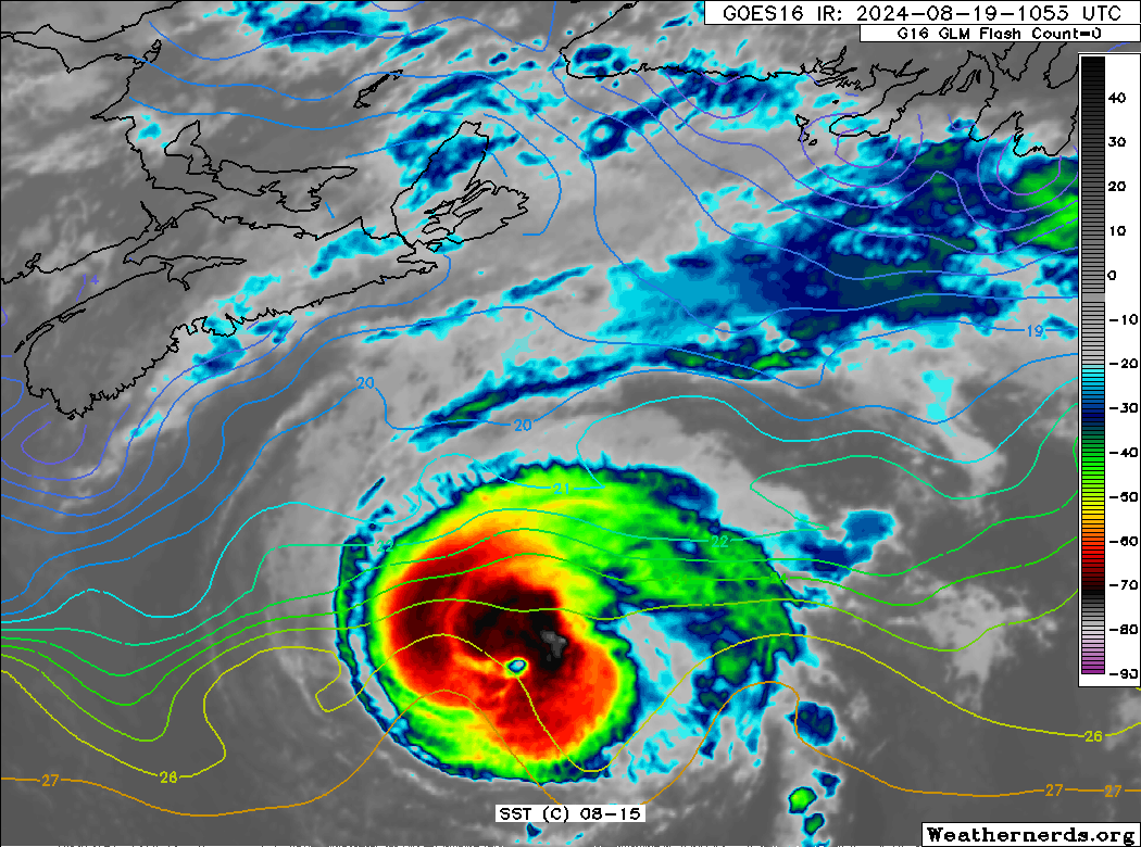
Two bad weather and climate news from Sicily but that connect it to Canada; finally, after a long period of drought, between yesterday afternoon and tonight the rains also arrived in Palermo, rains and storms. But unfortunately the storm of tonight was accompanied by an incredible waterspout that formed on the Gulf of Palermo. The waterspout hit a 56 meter sailboat (or maybe more than 70 meters), the Bayesian, anchored for the night in front of the coast of the gulf, specifically the small town of Porticello. In this boat there were more than 20 people; unfortunately the boat sank and some people died, including a Canadian chef
https://www.cbc.ca/news/world/italy-...dent-1.7298093

This news is incredible (it is the first time that a tragedy of this kind has happened) also because normally in the Gulf of Palermo waterspouts do not form or remain very far from the coast, but this summer the exceptionally high temperatures have warmed the waters of the gulf over 30'.

The other news concerns the fires in Canada; since this morning the sky of Palermo (and in general of Sicily and other areas of Italy and Europe), are not clear, but not because of the presence of clouds but because of fine dust that comes from the forest fires of Atlantic Canada, apparently from the woods of New Brunswick. I did not believe that in these areas there was a fire so big as to block the skies of Sicily. But it is confirmed by the atmosphere monitoring service of the European satellite Copernicus. Incredible, the sky of Palermo partially obscured by the fires in the Canadian forests.


https://atmosphere.copernicus.eu/cha...e=202408190600
__________________
The happiest time in the past of humanity? The Würm glaciation!
Reply With Quote
     
     
  #4407  
Old Posted Aug 19, 2024, 6:57 PM
MonctonRad's Avatar
MonctonRad MonctonRad is online now
Wildcats Rule!!
 
Join Date: Jun 2008
Location: Moncton NB
Posts: 40,315


I'm not aware of any forest fires currently burning in New Brunswick. The smoke must be western Canadian.
__________________
Go 'Cats Go
Reply With Quote
     
     
  #4408  
Old Posted Aug 19, 2024, 7:19 PM
Tancredi's Avatar
Tancredi Tancredi is offline
Free Palestine & Ukraine
 
Join Date: Jan 2019
Location: Italy (Sicily, Palermo)
Posts: 1,810
Quote:
Originally Posted by MonctonRad View Post


I'm not aware of any forest fires currently burning in New Brunswick. The smoke must be western Canadian.
In fact, looking more closely at the link below, the smoke appears to be coming from some fires in Western Canada
https://atmosphere.copernicus.eu/cha...e=202408240000
__________________
The happiest time in the past of humanity? The Würm glaciation!
Reply With Quote
     
     
  #4409  
Old Posted Aug 19, 2024, 7:24 PM
Marty_Mcfly's Avatar
Marty_Mcfly Marty_Mcfly is offline
Registered User
 
Join Date: Feb 2009
Location: St. John's, NL
Posts: 7,638
Very heavy rain falling in St. John's as the outer bands start inching closer.

The latest IR imagery shows Ernesto's eye becoming fairly unpronounced, starting to lose its cold cloud tops near the centre rotation. Likely now being impacted by the cooler SSTs and wind shear. Still moving in a northeast direction, waiting to see when the shift to the east-northeast will happen. The later it waits to shift direction the closer to Cape Race it'll track.
Reply With Quote
     
     
  #4410  
Old Posted Aug 19, 2024, 7:33 PM
SignalHillHiker's Avatar
SignalHillHiker SignalHillHiker is offline
I ♣ Baby Seals
 
Join Date: Jul 2012
Location: Sin Jaaawnz, Newf'nland
Posts: 36,120
Insanely heavy rain. But then sun in between each downpour. And it's sssooo humid. It feels like winter in Bermuda.
__________________
Note to self: "The plural of anecdote is not evidence."
Reply With Quote
     
     
  #4411  
Old Posted Aug 19, 2024, 8:31 PM
MonctonRad's Avatar
MonctonRad MonctonRad is online now
Wildcats Rule!!
 
Join Date: Jun 2008
Location: Moncton NB
Posts: 40,315
Quote:
Originally Posted by SignalHillHiker View Post
Insanely heavy rain. But then sun in between each downpour. And it's sssooo humid. It feels like winter in Bermuda.
Surprisingly hot and humid in Moncton too.

27C and partly cloudy at 5 PM with a humidex of 36. The showers that were forecast didn't happen. When I left the hospital after work, it felt like I was back in Florida when I stepped outside. I wonder if this came up the coast on the skirt tails of Ernesto?
__________________
Go 'Cats Go
Reply With Quote
     
     
  #4412  
Old Posted Aug 19, 2024, 9:03 PM
Marty_Mcfly's Avatar
Marty_Mcfly Marty_Mcfly is offline
Registered User
 
Join Date: Feb 2009
Location: St. John's, NL
Posts: 7,638
Quote:
Hurricane Ernesto Discussion Number 33
NWS National Hurricane Center Miami FL AL052024
500 PM AST Mon Aug 19 2024

Ernesto is maintaining its intensity at high latitudes. The
hurricane continues to have an eye feature, especially in the
mid-levels, and thunderstorms remain most organized north of the
center. Recent microwave images indicate that the circulation has
become titled from southwest to northeast with height, an indication
of increasing southwesterly vertical wind shear. The initial
intensity is held at 80 kt, in general agreement with the subjective
and objective Dvorak estimates.

Ernesto has likely peaked in strength. Since the hurricane has now
crossed the north wall of the Gulf Stream and moving into an
environment of increasing shear and drier air, steady or rapid
weakening is expected to begin soon. The environmental factors
should also cause extratropical transition, which will likely be
complete Tuesday morning. The NHC intensity forecast is the same as
the previous one and in line with the bulk of the guidance.
NHC maintaining a 80 kt strength for Ernesto (148 km/hr sustained winds) with gusts of 185 as of its 5:30 update. Very much dodging a bullet with this one, if it had tracked about 200 km west then we'd be looking at widespread damage.

I thought Hurricane Larry looked impressive for a hurricane this far north, but Ernesto takes the cake. No real signs of extra-tropical transition showing up on satellite or radar imagery, still pretty symmetrical, etc.
Reply With Quote
     
     
  #4413  
Old Posted Aug 19, 2024, 9:10 PM
q12's Avatar
q12 q12 is offline
Registered User
 
Join Date: Mar 2008
Location: Halifax
Posts: 5,106
^Agree, Hurricane Ernesto is still looking like an impressive Hurricane. It's got the classic Hurricane Buzzsaw look, very dangerous still at near Cat 2 Strength.

Reply With Quote
     
     
  #4414  
Old Posted Aug 19, 2024, 9:35 PM
Marty_Mcfly's Avatar
Marty_Mcfly Marty_Mcfly is offline
Registered User
 
Join Date: Feb 2009
Location: St. John's, NL
Posts: 7,638
^ Starting to see a little bit of dry air wrap in around the circulation now, probably the first hints of transition. Outer bands are now visible on Holyrood radar.
Reply With Quote
     
     
  #4415  
Old Posted Aug 19, 2024, 9:36 PM
SignalHillHiker's Avatar
SignalHillHiker SignalHillHiker is offline
I ♣ Baby Seals
 
Join Date: Jul 2012
Location: Sin Jaaawnz, Newf'nland
Posts: 36,120
That wasn't even outer bands?
__________________
Note to self: "The plural of anecdote is not evidence."
Reply With Quote
     
     
  #4416  
Old Posted Aug 19, 2024, 9:49 PM
Marty_Mcfly's Avatar
Marty_Mcfly Marty_Mcfly is offline
Registered User
 
Join Date: Feb 2009
Location: St. John's, NL
Posts: 7,638
I do not know what the proper terminology was for what caused the rain earlier, but it was not. Still a few hours away from them reaching here.
Reply With Quote
     
     
  #4417  
Old Posted Aug 19, 2024, 9:56 PM
SignalHillHiker's Avatar
SignalHillHiker SignalHillHiker is offline
I ♣ Baby Seals
 
Join Date: Jul 2012
Location: Sin Jaaawnz, Newf'nland
Posts: 36,120
Wow. Very glad this one is missing us with its worst.
__________________
Note to self: "The plural of anecdote is not evidence."
Reply With Quote
     
     
  #4418  
Old Posted Aug 20, 2024, 12:04 AM
flar's Avatar
flar flar is online now
..........
 
Join Date: Jan 2006
Location: Southwestern Ontario
Posts: 15,677
Feeling cool today with a gusty north wind. High of 20.4, low of 17 this morning. We ended up getting a few showers yesterday as this cold front moved in.

__________________
RECENT PHOTOS:
TORONTOSAN FRANCISCO ROCHESTER, NYHAMILTONGODERICH, ON WHEATLEY, ONCOBOURG, ONLAS VEGASLOS ANGELES
Reply With Quote
     
     
  #4419  
Old Posted Aug 20, 2024, 1:25 AM
Marty_Mcfly's Avatar
Marty_Mcfly Marty_Mcfly is offline
Registered User
 
Join Date: Feb 2009
Location: St. John's, NL
Posts: 7,638
Eye of Ernesto is now visible on Holyrood radar. No updates from NHC, but the CHC has listed the sustained winds as 140, as it did earlier today (even when the NHC had them estimated at 150). Losing structure but still quite a bit of outflow evident, still very strong tropical characteristics.

Does appear that my prediction earlier today may be correct, storm does appear to be tracking closer to NL than the CHC was modelling. Will be curious to see how close it gets to Cape Race tonight, under or over 100 kms?
Reply With Quote
     
     
  #4420  
Old Posted Aug 20, 2024, 1:50 AM
MonkeyRonin's Avatar
MonkeyRonin MonkeyRonin is offline
¥ ¥ ¥
 
Join Date: Sep 2006
Location: Vancouver
Posts: 10,544
Quote:
Originally Posted by hipster duck View Post
Last weekend's rainstorm pushed our total annual precipitation to 899.8 mm at YYZ.

That means that 2024 has had more precipitation, to date, than we had in all of 2023, 2022, 2021 and 2020.

Unless we can somehow get less than 150 mm of precipitation over the next 4.5 months (pretty much impossible), this will be the wettest year since recordkeeping began in 1939.

On the bright side, Toronto is looking incredibly lush & green this summer. And hey, no forest fires.
__________________
Reply With Quote
     
     
This discussion thread continues

Use the page links to the lower-right to go to the next page for additional posts
 
 
Reply

Go Back   SkyscraperPage Forum > Regional Sections > Canada
Forum Jump


Forum Jump


All times are GMT. The time now is 9:45 PM.

     
SkyscraperPage.com - Privacy Statement - Top

Powered by vBulletin® Version 3.8.7
Copyright ©2000 - 2026, vBulletin Solutions, Inc.