HomeDiagramsDatabaseMapsForum About
     

Go Back   SkyscraperPage Forum > Regional Sections > Canada


Closed Thread

 
Thread Tools Display Modes
     
     
  #4081  
Old Posted May 28, 2015, 2:11 AM
Loco101's Avatar
Loco101 Loco101 is offline
Registered User
 
Join Date: May 2013
Location: Timmins, Northern Ontario
Posts: 8,957
Quote:
Originally Posted by jeremy_haak View Post
Culturally, Parry Sound/Muskoka is definitely linked to the south. Physiographically, they are northern. Politically, it's split; Parry Sound is a district with no municipal services outside of municipalities (basically no upper-tier municipal structure), like the rest of Northern Ontario, Muskoka, on the other hand, does have county-wide municipal services like the rest of Southern Ontario.
The Southern parts of Northern Ontario are very similar physio-geographically but definitely not most of the region, for example, around the Sault, Sudbury and North Bay. But think of areas around Moosonee, Peawanuck, Fort Severn, Red Lake, Pickle Lake, Hornepayne, Hearst and even Timmins where I live. Different climates, trees, rock, waterways, etc..

I realize this thread is about highways but this discussion actually does have a lot to do in regards to why highways vary drastically across the province in terms of traffic, construction, widening, etc..
     
     
  #4082  
Old Posted May 28, 2015, 2:13 AM
manny_santos's Avatar
manny_santos manny_santos is offline
Registered User
 
Join Date: Jul 2006
Location: New Westminster
Posts: 5,141
Quote:
Originally Posted by sonysnob View Post
While I agree with that, I would say that as soon as you get north of the Severn River on both Hwy 400 and 11, the topography takes on a distinctly northern feel, even if the region is still considered part of southern Ontario.
By that logic, Northern Ontario would include much of the land immediately north and east of Kingston, as the topography in areas like Sharbot Lake and Lansdowne look a lot more like Northern Ontario than the south.
     
     
  #4083  
Old Posted May 28, 2015, 2:16 AM
Loco101's Avatar
Loco101 Loco101 is offline
Registered User
 
Join Date: May 2013
Location: Timmins, Northern Ontario
Posts: 8,957
Because of the Canadian Shield rock. But most of Northern Ontario does not have rock just like that! Only the Southern portions. Once you go further North, the rock, is less pronounced and you don't see the big rock cuts like you do around Sudbury or North Bay. AND, on the Hudson Bay Lowlands, you will find limestone! There is a limestone quarry in Moosonee.
     
     
  #4084  
Old Posted May 28, 2015, 11:23 AM
eemy's Avatar
eemy eemy is offline
Closed account
 
Join Date: Aug 2006
Posts: 4,425
Quote:
Originally Posted by manny_santos View Post
Even within Ontario, outside the GTA there's some strange conceptions people have of the world outside of their own immediate backyard. Just a couple days ago I was talking to a guy from Brockville and he was shocked that London is bigger than Kingston. He thought London had a population of 40,000, tops.

Likewise in Southwestern Ontario, some people I've talked to are surprised at Kingston's population. Some people think it's a lot smaller than it is, and some people think it's a lot bigger than it is. but few seem to know the actual ballpark it fits into.
My grandfather was initially surprised to learn that Ottawa is bigger than London, but he rarely strays beyond Huron County, so that's not that surprising.

Quote:
Originally Posted by Loco101 View Post
Because of the Canadian Shield rock. But most of Northern Ontario does not have rock just like that! Only the Southern portions. Once you go further North, the rock, is less pronounced and you don't see the big rock cuts like you do around Sudbury or North Bay. AND, on the Hudson Bay Lowlands, you will find limestone! There is a limestone quarry in Moosonee.
Geologically Ontario doesn't divide neatly into north and south. In the south, you have the Paleozoic rocks in the south and eastern portions (as well as Manitoulin Island) with the Precambrian Grenville Province appearing in the central bit in between, roughly from just north of Orillia, directly east to Kingston, and then north to the Renfrew area. In the north, the Grenville Province ends roughly around Sudbury and transitions into the even older Superior Province which is characterized more by greenstone belts throughout save for intrusive volcanic rocks in the area of Thunder Bay and Lake Nipigon related to the failed midcontinent rift under Lake Superior and Lake Nipigon. In the far north, the rock is actually of the same period as that found in southern and eastern Ontario. It actually features the youngest rock in the province to the south of Moosonee.

While the basement rock is interesting, the more recent surface geology related to glaciation has greater cultural implications. Effectively, you can divide Ontario into regions which have a lot of soil (and therefore agriculture) and regions which don't and this roughly corresponds to a north-south divide. The wedge in eastern Ontario corresponding to areas around Bancroft and so on actually has much more in common with areas further north than it does to areas to the south. Little agriculture, lots of forestry and mining history, far more similar geography and so on. In many ways, it feels more like Northern Ontario than New Liskeard, for example.

     
     
  #4085  
Old Posted May 28, 2015, 1:23 PM
MolsonExport's Avatar
MolsonExport MolsonExport is offline
Touching grass everyday.
 
Join Date: Oct 2003
Location: Otisburgh
Posts: 51,058
Quote:
Originally Posted by Loco101 View Post
Because of the Canadian Shield rock. But most of Northern Ontario does not have rock just like that! Only the Southern portions. Once you go further North, the rock, is less pronounced and you don't see the big rock cuts like you do around Sudbury or North Bay. AND, on the Hudson Bay Lowlands, you will find limestone! There is a limestone quarry in Moosonee.
Canadian Shield, shades of red:

wookie's pedia, of course
__________________
The whole problem with the world is that fools and fanatics are always so certain of themselves, and wiser people so full of doubts. (Bertrand Russell). Sweet Loretta fart thought she was a cleaner, but she was a frying pan. (John Lennon)
     
     
  #4086  
Old Posted May 28, 2015, 1:30 PM
Acajack's Avatar
Acajack Acajack is offline
Gros Méchant Loup
 
Join Date: Aug 2006
Location: Province 2, Canadian Empire
Posts: 72,949
Quote:
Originally Posted by manny_santos View Post
Even within Ontario, outside the GTA there's some strange conceptions people have of the world outside of their own immediate backyard. Just a couple days ago I was talking to a guy from Brockville and he was shocked that London is bigger than Kingston. He thought London had a population of 40,000, tops.

Likewise in Southwestern Ontario, some people I've talked to are surprised at Kingston's population. Some people think it's a lot smaller than it is, and some people think it's a lot bigger than it is. but few seem to know the actual ballpark it fits into.
If they think Kingston is bigger it may be because it's the control (destination) city for signs on the 401 in the GTA.

I just linked the thread back to highways!
__________________
Loin des yeux, loin du coeur.
     
     
  #4087  
Old Posted May 28, 2015, 1:43 PM
MolsonExport's Avatar
MolsonExport MolsonExport is offline
Touching grass everyday.
 
Join Date: Oct 2003
Location: Otisburgh
Posts: 51,058
Ottawa is the worst offender. You see the sign proclaiming you are entering Ottawa (pop 850K or whatnot) and 15 minutes later, you are still driving through a forested/farmy landscape.
__________________
The whole problem with the world is that fools and fanatics are always so certain of themselves, and wiser people so full of doubts. (Bertrand Russell). Sweet Loretta fart thought she was a cleaner, but she was a frying pan. (John Lennon)
     
     
  #4088  
Old Posted May 28, 2015, 2:01 PM
Acajack's Avatar
Acajack Acajack is offline
Gros Méchant Loup
 
Join Date: Aug 2006
Location: Province 2, Canadian Empire
Posts: 72,949
Quote:
Originally Posted by MolsonExport View Post
Ottawa is the worst offender. You see the sign proclaiming you are entering Ottawa (pop 850K or whatnot) and 15 minutes later, you are still driving through a forested/farmy landscape.
Yup. Even on the 401 the exit for Ottawa and the 416 looks like the exit for North Augusta Township Sideroad.
__________________
Loin des yeux, loin du coeur.
     
     
  #4089  
Old Posted May 28, 2015, 2:09 PM
MonctonRad's Avatar
MonctonRad MonctonRad is offline
Wildcats Rule!!
 
Join Date: Jun 2008
Location: Moncton NB
Posts: 40,955


That's nothing. In NB, they have a big sign on the TCH heading west just after the Canaan River bridge announcing that you are entering the "provincial capital region". Meanwhile, Fredericton is still a full 100 km away - and this 100 km is through dense forest........

I sometimes wonder what tourists think.
__________________
Go 'Cats Go
     
     
  #4090  
Old Posted May 29, 2015, 1:33 AM
vid's Avatar
vid vid is offline
I am a typical
 
Join Date: Apr 2004
Location: Thunder Bay
Posts: 39,065
The main CTV station in Northeastern Ontario is actually called Mid-Canada Television. I use the term Central Canada but use it to refer to Ontario and Manitoba, not Ontario and Quebec.

A lot of people from Northern Ontario often refer to themselves as just "Northerners". It's a bit of a mindfuck for those who haven't been to southern Ontario to think that Toronto is in the same province as us. A plane to that city goes over my house every 45 minutes during the day, it's literally the next closest city to get to (unless it's the morning, when we have our only two remaining direct flights to Winnipeg) but it still feels far away. The mining activity has boosted the connection between Thunder Bay and Toronto significantly, planes depart almost hourly between 6am and 8pm, and arrive almost hourly between 7am and midnight. The last plane from Toronto goes over my apartment at about the same time the last bus to downtown drives by it.

What is this discussion about again?
     
     
  #4091  
Old Posted May 29, 2015, 1:57 AM
eternallyme eternallyme is offline
Registered User
 
Join Date: Mar 2009
Posts: 5,243
To get back on topic...

What is the current status of planning for Highway 17 across Northern Ontario? Are there more sections ready for discussion?
     
     
  #4092  
Old Posted May 31, 2015, 2:27 AM
Loco101's Avatar
Loco101 Loco101 is offline
Registered User
 
Join Date: May 2013
Location: Timmins, Northern Ontario
Posts: 8,957
Quote:
Originally Posted by vid View Post
The main CTV station in Northeastern Ontario is actually called Mid-Canada Television. I use the term Central Canada but use it to refer to Ontario and Manitoba, not Ontario and Quebec.
Unfortunately MCTV (Mid Canada Television) no longer exists. It was started in Timmins by Conrad Lavigne. CTV bought it out entirely. What is left of it is now called CTV Northern Ontario and is owned by CTV-Bell Media. Each community had its own local news but now it is only broadcast from Sudbury with each city having a reporter or two.

And since this thread is about highways...I am hoping that the media shows the big push for proper highway rest areas along Northern Ontario highways. There are so many long stretches with no proper bathroom facilities. And it's not just along Hwys 11 and 17.
     
     
  #4093  
Old Posted May 31, 2015, 2:49 PM
BenTheGreat97's Avatar
BenTheGreat97 BenTheGreat97 is offline
Registered User
 
Join Date: Sep 2013
Location: Ottawa
Posts: 165
Quote:
Originally Posted by Loco101 View Post

And since this thread is about highways...I am hoping that the media shows the big push for proper highway rest areas along Northern Ontario highways. There are so many long stretches with no proper bathroom facilities. And it's not just along Hwys 11 and 17.
Maybe as they expand the highways, they can build mini enroutes like on the 401. Smaller and with less food options (because less market) but with an emphasis on tractor-trailer parking and bathroom facilities.
__________________
Check out my Flickr photostream!
http://www.flickr.com/photos/photosbybensenior/
     
     
  #4094  
Old Posted May 31, 2015, 4:00 PM
manny_santos's Avatar
manny_santos manny_santos is offline
Registered User
 
Join Date: Jul 2006
Location: New Westminster
Posts: 5,141
Quote:
Originally Posted by Loco101 View Post
And since this thread is about highways...I am hoping that the media shows the big push for proper highway rest areas along Northern Ontario highways. There are so many long stretches with no proper bathroom facilities. And it's not just along Hwys 11 and 17.
I can imagine highways like 144, 129, and 101 might be candidates for this, or longer Secondary Highways like 599. Trouble is, the traffic volumes on these routes may not be high enough to make anything viable.
     
     
  #4095  
Old Posted May 31, 2015, 7:34 PM
hipster duck's Avatar
hipster duck hipster duck is offline
Registered User
 
Join Date: Oct 2014
Location: Toronto
Posts: 4,850
Are there no rest stops at all along the 17/11?

In the US, there are a lot of volunteer-run rest stops in remote areas. The state builds the facilities, and some volunteers from a nearby church staff it and make sure there's always a pot of coffee. On a side note, seeing things like that in action actually gives me some hope for the United States.
     
     
  #4096  
Old Posted May 31, 2015, 8:11 PM
le calmar's Avatar
le calmar le calmar is offline
Registered User
 
Join Date: Dec 2006
Location: Ottawa
Posts: 5,240
I visited Kingston for the first time last week. As a urban-related stuff geek I was aware of the size of the city, but if I didn't have the information when I visited, I would have guessed 300,000. I was with my friend from Trois-Rivières and while both city are the same size and have vibrant downtowns, the urban character and the length of Princess street stood out as something unsual for a city this size. My friend had to admit the urban feeling was more pronounced than in Trois-Rivières.
     
     
  #4097  
Old Posted May 31, 2015, 8:23 PM
mattpa's Avatar
mattpa mattpa is offline
Registered User
 
Join Date: Jun 2014
Location: Steinbach
Posts: 145
there are areas along highway 17 between kenora and t bay but few its usually just gravel to pull onto 10 ft of the road
     
     
  #4098  
Old Posted May 31, 2015, 8:27 PM
sonysnob sonysnob is offline
Registered User
 
Join Date: Aug 2011
Posts: 1,797
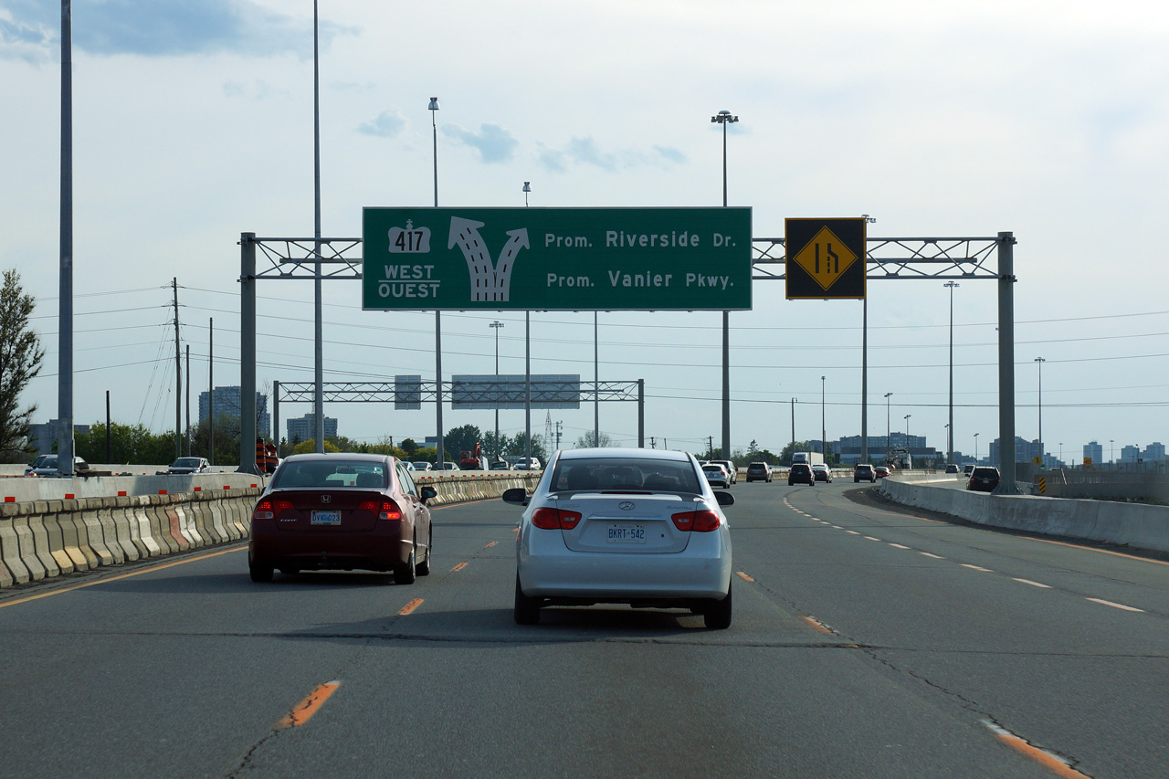
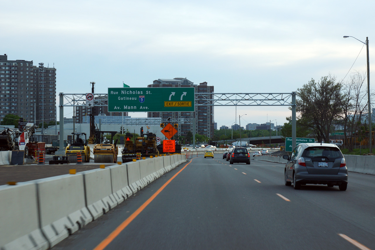
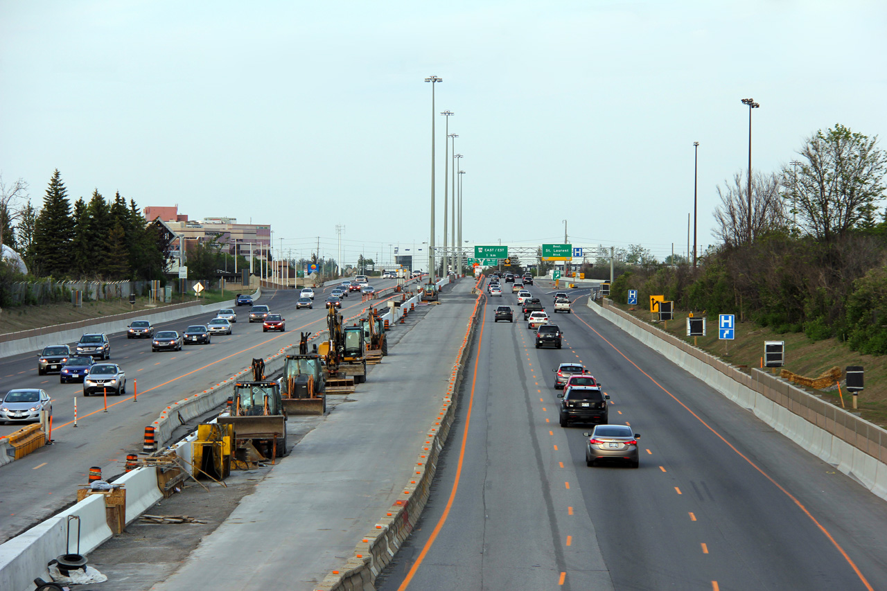
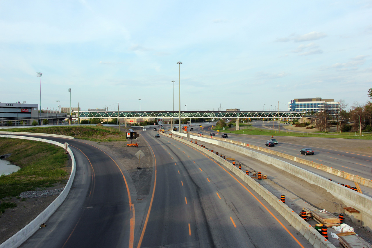
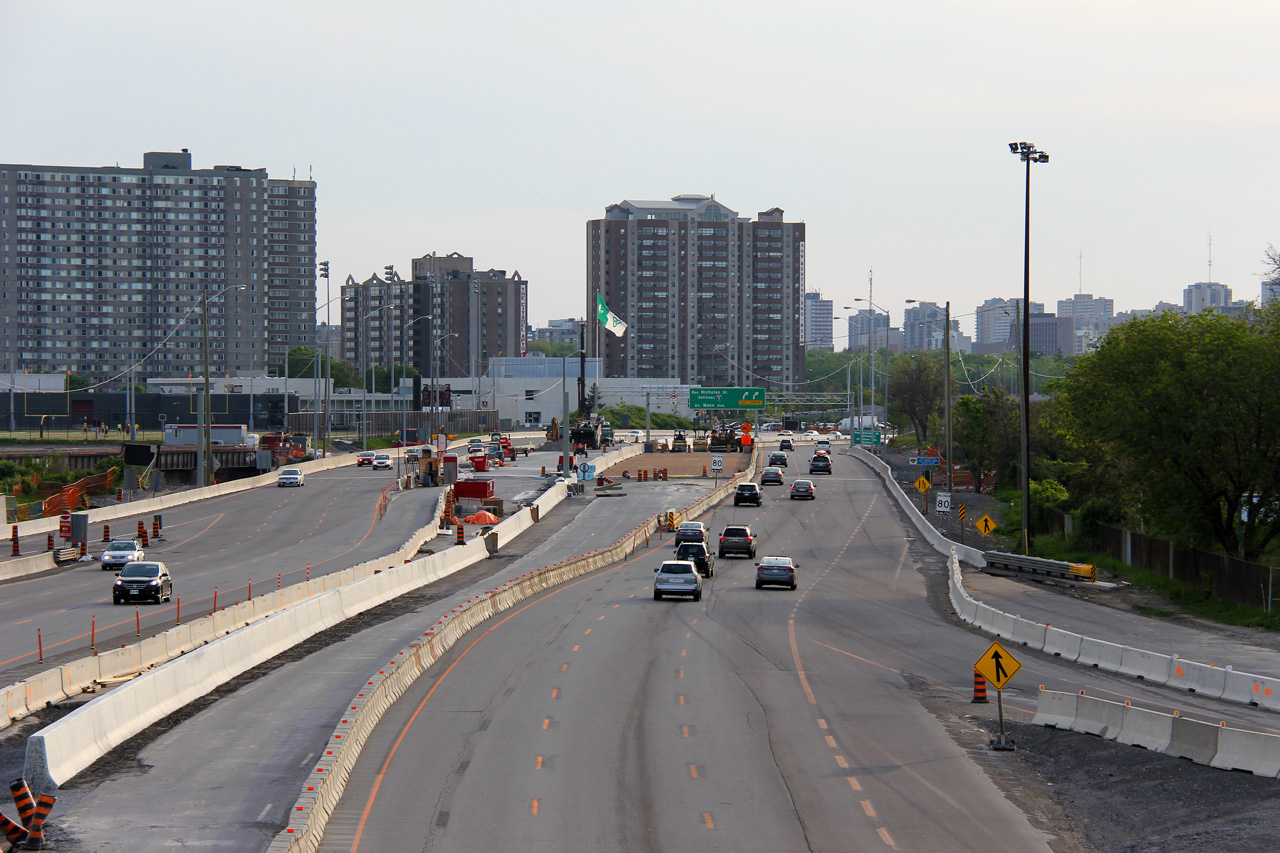
Some pictures of the 417 construction related to the LRT construction in eastern Ottawa:


Easterly view from the Belfast Road overpass


Easterly view along the 417 towards the new pedestrian overpass from the Vanier Parkway overpass


Westerly view towards the Rideau River bridge from the Vanier Parkway overpass


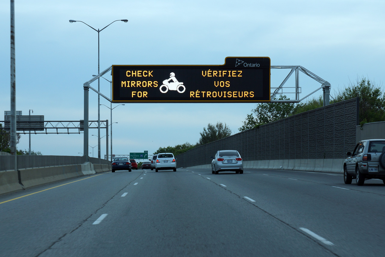
I've also uploaded some new photos of Hwy 400 north of Barrie:
http://www.asphaltplanet.ca/ON/hwy_400_images/Hwy400_p3_images.htm
     
     
  #4099  
Old Posted May 31, 2015, 9:02 PM
FrAnKs's Avatar
FrAnKs FrAnKs is offline
Registered User
 
Join Date: Jul 2005
Location: Ville de Québec / Quebec city
Posts: 5,930
^ Love those bilingual road signs !
__________________
PROVINCE OF QUEBEC ==> 9 050 000
MONTREAL METRO ==> 4 600 000
QUEBEC CITY METRO ==> 900 000
     
     
  #4100  
Old Posted May 31, 2015, 9:37 PM
sa230e sa230e is offline
Registered User
 
Join Date: Jun 2012
Location: Windsor, ON
Posts: 454
So they're installing an LRT in the median?
     
     
This discussion thread continues

Use the page links to the lower-right to go to the next page for additional posts
 
 
Closed Thread

Go Back   SkyscraperPage Forum > Regional Sections > Canada
Forum Jump


Forum Jump


All times are GMT. The time now is 8:06 AM.

     
SkyscraperPage.com - Privacy Statement - Top

Powered by vBulletin® Version 3.8.7
Copyright ©2000 - 2026, vBulletin Solutions, Inc.