HomeDiagramsDatabaseMapsForum About
     

Go Back   SkyscraperPage Forum > Discussion Forums > City Discussions


Reply

 
Thread Tools Display Modes
     
     
  #21  
Old Posted Nov 17, 2025, 3:13 PM
iheartthed iheartthed is offline
Registered User
 
Join Date: Oct 2009
Location: New York
Posts: 11,926
Quote:
Originally Posted by muppet View Post
I think the most impressive is Chengdu, building 670km / 412 miles in 15 years (27 miles each year).

This is the equivalent to planning, building and opening the London's tunneled sections of the Elizabeth Line each year (read: the main part that actually goes through the city, not the suburbs that was overland and mostly already built). The Elizabeth line took 14 years to build and 7 years to plan.


by comparison in the same 15 year timeframe:

Shanghai built 400km / 250 miles = 16.7miles per year

Beijing 505km / 314 miles = 21 miles per year


Other timescales

Zhengzhou built 450km / 280 miles in 12 years = 23 miles per year

Hangzhou 516km / 321 miles in 13 years = 25 miles per year


All of these new additions bigger than London or NYC.

Many studies have been found on how they're able to build so quickly, and the main takeaway is that there's far less middlemen - legislation, studies, redesigns -despite better engineering, deeper tunneling, larger and prettier stations, and just as much history to dig through. Also it's largely standardised and automated to every system across the country, so less bespoke designs needed, and new specialists or contractors to hire. Notably far less labour needed too, thanks to the automated construction.
I'm guessing that Chinese systems like Beijing and Shanghai have longer lengths than New York or London because they have to cover larger areas in those cities. Beijing has the same number of stations as New York, despite having over 2x the system length. Beijing also has twice the population of New York and over 20x the land area.

The per capita ridership of Beijing's system also appears to be much lower than New York's. According to the Wikipedia data, New York City had roughly 230 rides per resident in 2024 compared to Beijing's 165 rides per resident.

Third, the Wikipedia page separates the Staten Island Railway from the NYC Transit system for some reason, so technically there are 262 miles of rapid transit rail within New York City, not 248. (If you add the PATH it increases to about 278, but most of the PATH's system is outside of New York City.)
Reply With Quote
     
     
  #22  
Old Posted Nov 17, 2025, 3:39 PM
muppet's Avatar
muppet muppet is offline
if I sang out of tune
 
Join Date: Sep 2004
Location: London
Posts: 6,506
Im not sure why Staten Island Railway's on there, that would be the equivalent of the 174km long Overground system in London (mass transit, rapid train that has a start terminus and an end terminus in the city proper -it often shares tube stations and parts of it were once the tube, but renamed). The O is extensively used as it allows passengers cross-city transport without having to enter the centre each time, unlike the radial tube network. 625,000 people ride it each day.
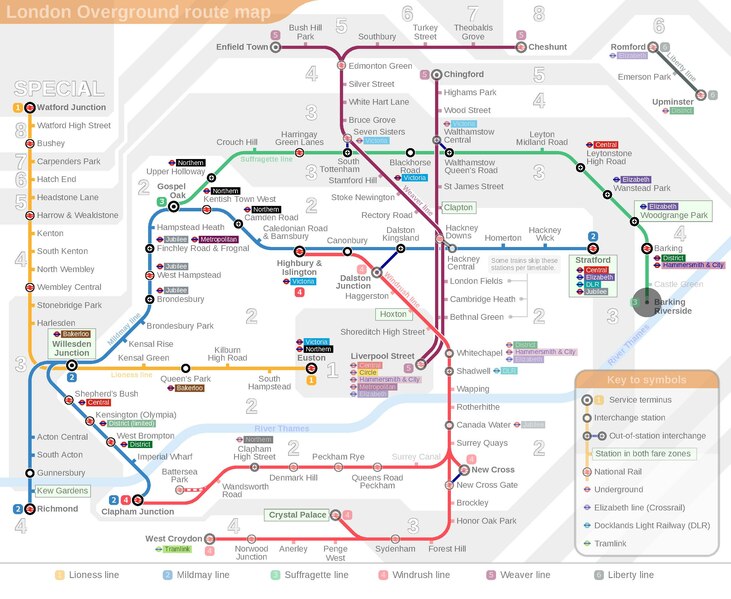


PATH would be the equivalent of a few other lines in London, such as the Elizabeth one (118km, a whopping 800,000 users daily). It was initially planned as a new tube line, before they rebranded it as a standalone midway through construction.


or the 225km Thameslink (850,000 users daily)
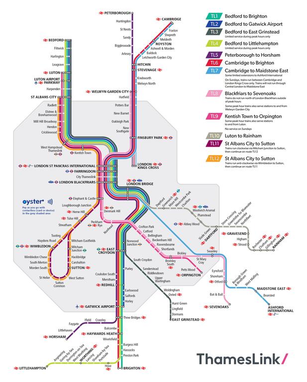


These mass transit systems within the city (not mentioned, but if you include the DLR too - London's light rail network), would put London at 945 km alone, overtaking Beijing and Shanghai. That doesn't include any mainline trains that bypass or terminate at any of the 14 major rail termini, who have hundreds more stations and tracks (within the city, used mass transit-wise).


But yeah, I wish they'd consolidate it all, or at least have a list of consolidated systems. Paris, Seoul and Tokyo notably miss out too.

I think Beijing has less metro rides per resident as there are so many options for transport there - a bike ride for hours is just 80c, and they're everywhere. Once you take the metro to a near enough stop, you likely switch to electric bike. Having spent some time in China recently, the metro networks are indeed far ranging, have great coverage, are frequent, safe, clean, all mod cons -you can even choose which carriage beforehand by checking how crowded it is or the live temperature of the aircon (cooler in the middle, less so at either end), before the train even approaches.

However it's not total plain sailing with long times to even get to the platform as theyre so deep, with long transfers (some took 30 mins with crowds), and often multiple times -by comparison for Central London you only ever need to transfer once, at most twice. It was often frustrating depending on the city's layout -Chongqing I'm talking to you. Although never as crowded, frequencies weren't too hot either -about 7 mins between trains when I'm used to 2-4 a lot of the time. In London we rely on the highest frequencies in the world to manage the crowds, as the tunnels are old and smaller, forcing the trains into bullet sizes (hence the nickname of the Tube). If a rush hour train is delayed by 1 or 2 mins it can mean the crowd doubling and trying to get on. Sounds lovely and convenient on paper but it's often disastrous.

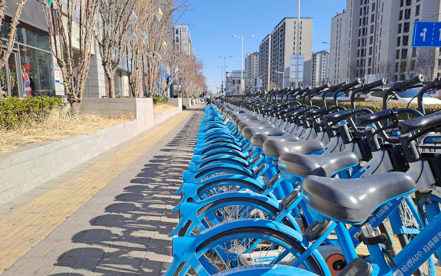
However the bikes in China are an absolute gamechanger, SO easy to find (millions of them everywhere, different companies, even in random rural-like areas), to use (scan the barcode to unlock), and incredibly cheap -pretty much free. You can use the bike lanes or the traffic any which way you want. I'd often use them instead of a second metro ride.


Last edited by muppet; Nov 23, 2025 at 11:51 AM.
Reply With Quote
     
     
  #23  
Old Posted Nov 17, 2025, 4:24 PM
hipster duck's Avatar
hipster duck hipster duck is offline
Registered User
 
Join Date: Oct 2014
Location: Toronto
Posts: 4,866
This is a hard exercise. All railways are not created equal, and all freeways are not created equal, either.

A LRT is not the same as a 10-car heavy rail metro, and a 4-lane highway with cloverleaf interchanges is not the same as a 12-lane highway with separate express/HOV/HOT lanes and 4-level stack interchanges.

Looking at a metro map or a highway map on something like Openstreetsmap won't tell you much.

I don't know which city wins, but I'm pretty sure an Asian megacity, which exclusively runs large heavy rail trains everywhere is going to win the "most extensive rail system" award. And an American city is going to win the highway contest. For highways, Greater LA probably in absolute terms, but on a per capita basis it's probably some other sunbelt city.
Reply With Quote
     
     
  #24  
Old Posted Nov 17, 2025, 4:32 PM
Crawford Crawford is offline
Registered User
 
Join Date: Nov 2003
Location: Brooklyn, NYC/Polanco, DF
Posts: 34,812
I think KC has the highest ratio of freeway miles to population. I don't believe they factored in relative road capacity.
Reply With Quote
     
     
  #25  
Old Posted Nov 17, 2025, 4:43 PM
iheartthed iheartthed is offline
Registered User
 
Join Date: Oct 2009
Location: New York
Posts: 11,926
Quote:
Originally Posted by muppet View Post
Im not sure why Staten Island Railway's on there, that would be the equivalent of the 174km long Overground system in London (a rapid train that has a start terminus and an end terminus in the city proper -it often shares tube stations and parts of it were once part of the tube, but renamed).
It is a rapid-transit line so it should be accounted for but I was surprised that it wasn't included as part of the NYC Subway totals. However, looking into it a little more, the SI Railway is owned and operated by a different subsidiary than the rest of the NYC subway. This appears to be a legacy structure from when the NYC transit systems were consolidated under the state control in the 1970s.

The SI Railway uses the same fare system as the NYC subway, and the rolling stock overlaps with the rolling stock on the letter lines of the NYC subway. The only distinction from a rider experience is that it is the only line in the system without that you cannot directly connect to from another line.
Reply With Quote
     
     
  #26  
Old Posted Nov 17, 2025, 5:16 PM
Nouvellecosse's Avatar
Nouvellecosse Nouvellecosse is online now
Volatile Pacivist
 
Join Date: Aug 2005
Location: Nova Scotia
Posts: 11,203
Quote:
Originally Posted by hipster duck View Post
This is a hard exercise. All railways are not created equal, and all freeways are not created equal, either.

A LRT is not the same as a 10-car heavy rail metro, and a 4-lane highway with cloverleaf interchanges is not the same as a 12-lane highway with separate express/HOV/HOT lanes and 4-level stack interchanges.

Looking at a metro map or a highway map on something like Openstreetsmap won't tell you much.

I don't know which city wins, but I'm pretty sure an Asian megacity, which exclusively runs large heavy rail trains everywhere is going to win the "most extensive rail system" award. And an American city is going to win the highway contest. For highways, Greater LA probably in absolute terms, but on a per capita basis it's probably some other sunbelt city.
Yes, very true. Lines on a map tell very little about what's actually happening on the ground. Not only can capacity vary quite a bit with both rail and roads, but with rail the capacity is also affected by service frequency and operating speed while the operation can also vary a lot and affect usability. The same line on a map could represent service of every 8 minutes peak and 12 minutes off-peak or 2 minutes peak and 5-minutes off-peak. Yet the latter is a much more impressive service.
__________________
"The reasonable man adapts himself to the world; the unreasonable one persists in trying to adapt the world to himself. Therefore all progress depends on the unreasonable man." - George Bernard Shaw
Don't ask people not to debate a topic. Just stop making debatable assertions. Problem solved.
Reply With Quote
     
     
  #27  
Old Posted Nov 17, 2025, 5:33 PM
hipster duck's Avatar
hipster duck hipster duck is offline
Registered User
 
Join Date: Oct 2014
Location: Toronto
Posts: 4,866
Quote:
Originally Posted by Crawford View Post
I think KC has the highest ratio of freeway miles to population. I don't believe they factored in relative road capacity.
KC is a good contender.

I'm not sure if it wins in terms of per capita lane miles, but I remember San Antonio had some highway infrastructure that was really overscaled for a city of its size. For example, the elevated expansion of I-10 (I think the old highway is used as an express through-route) reminds me of LA's Harbor freeway, or what you might find in an Asian megacity that's tight on space.

Or this stack interchange, which looks like it was built in the early 1980s when SA probably had 850,000 people.
Reply With Quote
     
     
  #28  
Old Posted Nov 17, 2025, 5:38 PM
muppet's Avatar
muppet muppet is offline
if I sang out of tune
 
Join Date: Sep 2004
Location: London
Posts: 6,506
Quote:
Originally Posted by iheartthed View Post
It is a rapid-transit line so it should be accounted for but I was surprised that it wasn't included as part of the NYC Subway totals. However, looking into it a little more, the SI Railway is owned and operated by a different subsidiary than the rest of the NYC subway. This appears to be a legacy structure from when the NYC transit systems were consolidated under the state control in the 1970s.

The SI Railway uses the same fare system as the NYC subway, and the rolling stock overlaps with the rolling stock on the letter lines of the NYC subway. The only distinction from a rider experience is that it is the only line in the system without that you cannot directly connect to from another line.
I think both SIR and Overground don't get the metro moniker simply because they're not built underground - go figure - and despite there being plenty of tube coming up for air in long stretches.

London's Overground is run by the same company TfL, same payment systems, often same stations and even platforms etc -but the trains look different. People often don't notice it though:


And inside even more so:


What's the SI line like? I imagine it's as busy and frequent as the rest of the metro

Last edited by muppet; Nov 18, 2025 at 4:30 AM.
Reply With Quote
     
     
  #29  
Old Posted Nov 17, 2025, 5:50 PM
Wigs's Avatar
Wigs Wigs is offline
Great White North
 
Join Date: Nov 2003
Location: Niagara Region
Posts: 16,177
Quote:
Originally Posted by Crawford View Post
I think KC has the highest ratio of freeway miles to population. I don't believe they factored in relative road capacity.
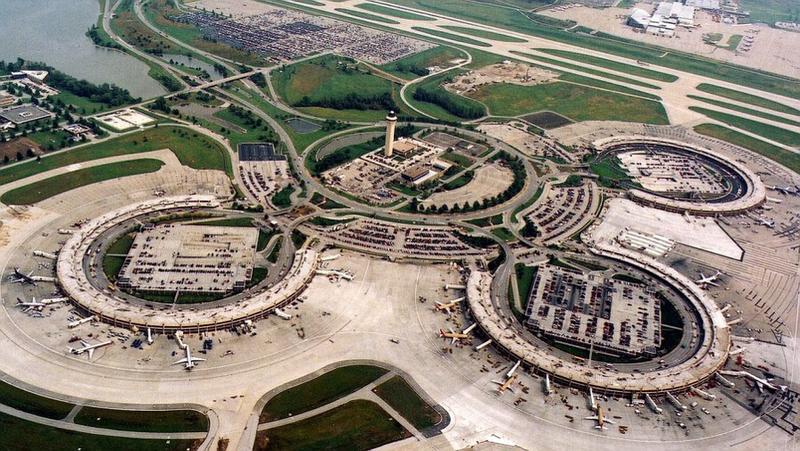
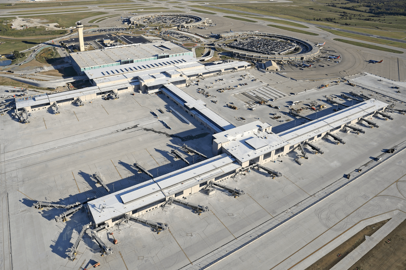
Kansas City, Missouri has done two things right.

1. Built a brand new airport terminal, on time and on budget.

2. Built a streetcar line, and new expansion that just opened. Pretty much on time, and one streetcar Rep said in a video the expansion was $7M under budget.

The streetcar is in a TDD-Transit Development District so businesses pay a fee towards the streetcar and then customers in the area pay an extra bit of sales tax on purchases. So combined it fully funds the streetcar so it's free to ride for both locals and tourists alike. Just hop on and off at will. Currently the streetcar runs at 10 minute intervals and the expansion includes sections of streetcar only lane.

The expanded route hits all of the major attractions (aside from the two largest sports teams stadiums) in Central KC and when the riverfront extension is opened will be great for women's soccer fans or those that have never spent time by the river. One can also get to Country Club Plaza and the University of Missouri Kansas City (UMKC) on the line now.

I'm confident it will supercharge development in the Midtown corridor and create infill near the line as well. It's not just a tourist toy.

The highways are not as much of an obstruction with the streetcar connecting these inner city neighborhoods. Further expansion proposals are in the works that might see an East-West Line that connects across the State like to UK Medical Center in the West to the Veterans Hospital in the East part of KC.


bigger map photo: https://kcstreetcar.org/wp-content/uploads/2025/10/2978_KCSA_PylonMap_RUN-scaled.png

KC Streetcar uses Spanish CAF Urbos trams. Made in USA, in Elmira Heights, NY.

source: https://kctoday.6amcity.com/things-to-do-along-the-kansas-city-streetcar-route

There's also a project in the works to cap one of the interstates with a new downtown park so the highway will be a tunnel underneath. I'm not sure of the status of that project.

I've been following the streetcar project for 3 years now and am bullish on KC becoming a pretty good city, particularly for the Midwest.

Last edited by Wigs; Nov 18, 2025 at 3:58 AM. Reason: *new airport terminal
Reply With Quote
     
     
  #30  
Old Posted Nov 17, 2025, 5:59 PM
muppet's Avatar
muppet muppet is offline
if I sang out of tune
 
Join Date: Sep 2004
Location: London
Posts: 6,506
SUCH A GOOD IDEA^^ Free transport paid for by small charges on businesses and customers, attracts more business and customers
Reply With Quote
     
     
  #31  
Old Posted Nov 17, 2025, 6:13 PM
wwmiv wwmiv is offline
Registered User
 
Join Date: Sep 2009
Location: Austin -> San Antonio -> Columbia -> San Antonio -> Chicago -> Austin -> Denver -> Austin
Posts: 5,806
Quote:
Originally Posted by hipster duck View Post
KC is a good contender.

I'm not sure if it wins in terms of per capita lane miles, but I remember San Antonio had some highway infrastructure that was really overscaled for a city of its size. For example, the elevated expansion of I-10 (I think the old highway is used as an express through-route) reminds me of LA's Harbor freeway, or what you might find in an Asian megacity that's tight on space.

Or this stack interchange, which looks like it was built in the early 1980s when SA probably had 850,000 people.
The double deck was also completed way back in the 1980s.

410 and 281 have been the major projects in city limits this century. The 1604 expansion as well.
__________________
Houston: 2.4m (+3.9%) + MSA suburbs: 5.4m (+12%) + CSA exurbs: 200k (+5%)
Dallas: 1.3m (+2%) / FtW: 1.0m (+10%) + suburbs: 6.4m (9%) + exurbs: 566k (+9%)
San Antonio: 1.5m (+6%) + MSA suburbs: 1.2m (+10%) + CSA exurbs: 82k (+3%)
Austin: 994k (+3%) + MSA suburbs: 1.6m (+18%)
Texas (whole): 31.29m (+7%) / Texas (balance): 8.6m (+3%)
Reply With Quote
     
     
  #32  
Old Posted Nov 17, 2025, 6:32 PM
Wigs's Avatar
Wigs Wigs is offline
Great White North
 
Join Date: Nov 2003
Location: Niagara Region
Posts: 16,177
Quote:
Originally Posted by muppet View Post
SUCH A GOOD IDEA^^ Free transport paid for by small charges on businesses and customers, attracts more business and customers
Agreed! I wish this was done more. And despite the lunatic MAGA/GOP type talking points it did not become a mobile homeless shelter

There's a mens clothier, Michael's, a family run institution that's been around for 120 years (old for any business in USA/or Canada). They have a photo from when the original streetcars went up and down Main St. in Kansas City. The owner was pissed off at the construction and thought it wouldn't help.

Well he went from complete naysayer, NIMBY, to one of its biggest cheerleaders. He said his business has skyrocketed with younger clientele and new walk-in customers.
"I'm eating crow right now. I was so wrong"

This was from June 2024. The expansion south to UMKC just opened last month. (embedding didn't work)
https://youtu.be/j-O9q7LVVqo?si=tb90XpLjCbqQvhp6
Reply With Quote
     
     
  #33  
Old Posted Nov 17, 2025, 6:57 PM
Doady's Avatar
Doady Doady is offline
Registered User
 
Join Date: Apr 2004
Posts: 5,166
Free transit in KC is a disaster. Terrible ridership, and ridership still falling... No fares just starving the system of funding and forcing service cuts. All very predictable. You can see other cities like Hamilton that freeze fares for years and begins a downward spiral for ridership and service.

Kansas City will lose nearly half its bus routes under transit agency's drastic cost-cutting plan
Quote:
The Kansas City Area Transportation Authority is bracing for drastic cuts to service if Kansas City passes its proposed budget, according to documents obtained by KCUR.

To maintain the current status quo for its Kansas City operations — which already includes long wait times and the fewest bus routes the agency’s had in decades — the KCATA needs about $117 million. The city plans to give the agency $71 million in its 2025-2026 budget.

Without any more funding, KCATA will cut 13 of its 29 routes in Kansas City, Missouri. Those cuts would affect more than 6,500 people, about 18% of the city’s total weekday ridership.
Reply With Quote
     
     
  #34  
Old Posted Nov 17, 2025, 7:04 PM
Wigs's Avatar
Wigs Wigs is offline
Great White North
 
Join Date: Nov 2003
Location: Niagara Region
Posts: 16,177
Doady's gonna hate on a city that made a banger for the streetcar. The funding for streetcar is completely separate from the bus system, ya Negative Nancy

Video Link
Reply With Quote
     
     
  #35  
Old Posted Nov 17, 2025, 7:15 PM
Doady's Avatar
Doady Doady is offline
Registered User
 
Join Date: Apr 2004
Posts: 5,166
Of course, streetcar is a separate thing from bus. And that's the problem.
Reply With Quote
     
     
  #36  
Old Posted Nov 17, 2025, 7:17 PM
mhays mhays is offline
Never Dell
 
Join Date: Jul 2001
Posts: 21,100
Kansas City built a new airport terminal, not a new airport. It's replaced one of the original circular terminals. (A new airport is a whoole nother level of challenge.)

The streetcar looks like a good addition, but I hope it's every five minutes instead of every ten pretty soon. It should be often enough that a schedule isn't required. PS, I agree that local transit isn't well used...extrapolating from APTA Q2 stats about 1% of locals ride any sort of transit per weekday.
__________________
"Alot" has never been a word.
Reply With Quote
     
     
  #37  
Old Posted Nov 17, 2025, 7:59 PM
Wigs's Avatar
Wigs Wigs is offline
Great White North
 
Join Date: Nov 2003
Location: Niagara Region
Posts: 16,177
fixed my wording, mhays. Apparently they'll keep the old terminal parking structures for employees and demolish(ed) pretty much everything else. Extra pavement areas can be overnight aircraft parking.

In the high security post 9/11 world the old terminals that were once convenient were a hassle, and dark with poor renovations done for security purposes.


KC streetcar definitely has the right team in place (1 min YouTube short)
Video Link

Last edited by Wigs; Nov 18, 2025 at 5:18 PM.
Reply With Quote
     
     
  #38  
Old Posted Nov 19, 2025, 5:47 PM
Pavlov's Avatar
Pavlov Pavlov is online now
Khan
 
Join Date: Sep 2004
Location: Kingston, Ontario
Posts: 5,005
Quote:
Originally Posted by MolsonExport View Post
Then there is Beijing Subway:
Unreal. Beijing had two lines (the second ring road line and the Chang'An Avenue line) when I lived there.
__________________
Confucius says:
With coarse rice to eat, with water to drink, and my bended arm for a pillow - I have still joy in the midst of these things. Riches and honors acquired by unrighteousness are to me as a floating cloud.
Reply With Quote
     
     
End
 
 
Reply

Go Back   SkyscraperPage Forum > Discussion Forums > City Discussions
Forum Jump


Forum Jump


All times are GMT. The time now is 1:48 PM.

     
SkyscraperPage.com - Privacy Statement - Top

Powered by vBulletin® Version 3.8.7
Copyright ©2000 - 2026, vBulletin Solutions, Inc.