HomeDiagramsDatabaseMapsForum About
     

Go Back   SkyscraperPage Forum > Regional Sections > Canada > Manitoba & Saskatchewan


Closed Thread

 
Thread Tools Display Modes
     
     
  #3821  
Old Posted Dec 18, 2020, 11:04 PM
buzzg buzzg is offline
Registered User
 
Join Date: Apr 2013
Posts: 7,834
Quote:
Originally Posted by esquire View Post
I know that for at least the first 25-odd years The Forks' vision for that area was to have it take on an Indigenous character. With what exactly I don't recall, I don't think it was supposed to be too heavily built up. But I'm not sure if that's still the case.
This is correct, it will never be developed. It's now called Niizhoziibean.

It's part of the walking loop and this year they started construction of a small seating/gathering area intended for drum circles and spiritual ceremonies. Should be done in spring. This is also why they moved the biovator.

Can find out more about it here: https://www.theforks.com/attractions/niizhoziibean
     
     
  #3822  
Old Posted Dec 18, 2020, 11:09 PM
esquire's Avatar
esquire esquire is offline
Registered User
 
Join Date: Oct 2001
Posts: 37,480
^ Thanks for the link. That's a pretty good plan.. I'm fine with The Forks getting built up, but it makes sense to keep some of the site forested. It's kind of amazing that it remained that way all those years despite being pretty well the dead centre of the city.
     
     
  #3823  
Old Posted Dec 18, 2020, 11:36 PM
Andy6's Avatar
Andy6 Andy6 is offline
Starring as himself
 
Join Date: Mar 2002
Location: Toronto Yorkville
Posts: 9,760
Quote:
Originally Posted by esquire View Post
^ Thanks for the link. That's a pretty good plan.. I'm fine with The Forks getting built up, but it makes sense to keep some of the site forested. It's kind of amazing that it remained that way all those years despite being pretty well the dead centre of the city.
I don't think the forest goes back that far. There was another rail line through there until the 1970s so the land wasn't really usable. Old illustrations suggest that the south point was just a field. To the best of my knowledge, there really weren't any forests as such in Winnipeg before people began planting trees in the 19th century. If there had been any, they probably would have been cut down for firewood.
__________________
crispy crunchy light and snappy
     
     
  #3824  
Old Posted Dec 18, 2020, 11:39 PM
Wpg_Guy's Avatar
Wpg_Guy Wpg_Guy is online now
Moderator
 
Join Date: Aug 2002
Location: Winnipeg, Manitoba
Posts: 7,405
Quote:
Originally Posted by H2man View Post
Just looking at google maps and wondering...has there ever been an appetite to develop the South Point Park, on the south side of the Assinaboine across from The Forks?

I don't mean a complete urbanization- even just development as a park, with something unique. At the point it's literally the fork of the two rivers. I have heard of some resistance to the development of the parcels of surface lots across from CMHR into high-ish rise residentials, with the argument being that it "ruins" the separation of The Forks as a special place from the downtown and its urban-ness (I do not share this opinion).

So in response, The Forks itself could just grow across the Assinaboine. Again, I don't want to wreck perfectly good central greenspace, but it's ripe for something more special than what's currently there, I think.

Any thoughts on that? Just trying to spur discussion.

There is development happening in there right now, some landscaping/Amphitheatre was started this fall.
__________________
Winnipeg Act II - April 2024

Winnipeg Developments

In The Future Every Building Will Be World-Famous For Fifteen Minutes.
     
     
  #3825  
Old Posted Dec 19, 2020, 2:18 AM
esquire's Avatar
esquire esquire is offline
Registered User
 
Join Date: Oct 2001
Posts: 37,480
Quote:
Originally Posted by Andy6 View Post
I don't think the forest goes back that far. There was another rail line through there until the 1970s so the land wasn't really usable. Old illustrations suggest that the south point was just a field. To the best of my knowledge, there really weren't any forests as such in Winnipeg before people began planting trees in the 19th century. If there had been any, they probably would have been cut down for firewood.
I wasn't suggesting that it's some kind of virgin forest or anything like that, just surprised that it was left the way it is and never built up, paved over and integrated into the urban fabric of the area. Unless I'm mistaken I don't think there were ever any long-standing buildings on that site... I don't think CN had any of its facilities there or anything like that. If there were any, they were gone long before my time.
     
     
  #3826  
Old Posted Dec 19, 2020, 3:17 AM
Andy6's Avatar
Andy6 Andy6 is offline
Starring as himself
 
Join Date: Mar 2002
Location: Toronto Yorkville
Posts: 9,760
Quote:
Originally Posted by esquire View Post
I wasn't suggesting that it's some kind of virgin forest or anything like that, just surprised that it was left the way it is and never built up, paved over and integrated into the urban fabric of the area. Unless I'm mistaken I don't think there were ever any long-standing buildings on that site... I don't think CN had any of its facilities there or anything like that. If there were any, they were gone long before my time.
I guess it was just CN property and not very usable because of a lack of access. It was crossed by two busy rail lines and there was also a little spur line that connected them, running through the middle of the point, making the land even less usable.

I have a photo that shows the area around 1930 and the only trees were along the riverbank. There was nothing there, it appears, other than the rail lines.

__________________
crispy crunchy light and snappy
     
     
  #3827  
Old Posted Dec 19, 2020, 6:38 AM
Jeff's Avatar
Jeff Jeff is offline
Registered User
 
Join Date: Oct 2002
Location: Winnipeg|MB
Posts: 2,316
from being a stripped and desolate patch of land in the midst of a major freight yard this point of land has regenerated back into a pristine state quite remarkably!
__________________
instagram: @jeff_vernaus
     
     
  #3828  
Old Posted Dec 19, 2020, 3:25 PM
Andy6's Avatar
Andy6 Andy6 is offline
Starring as himself
 
Join Date: Mar 2002
Location: Toronto Yorkville
Posts: 9,760
Quote:
Originally Posted by Jeff View Post
from being a stripped and desolate patch of land in the midst of a major freight yard this point of land has regenerated back into a pristine state quite remarkably!
You're right, Jeff. It's hard to understand how, if the soil and climate make it so easy for trees to grow, there seem to have been virtually no trees in the first place in the area, other than scrub oaks along the riverbank.
__________________
crispy crunchy light and snappy
     
     
  #3829  
Old Posted Dec 19, 2020, 3:52 PM
plrh plrh is offline
Registered User
 
Join Date: Apr 2012
Location: Winnipeg
Posts: 944
I would bet that land is 2 or 3m higher than original prairie from all of the rail embankment fill. Interesting idea about the trees. Similarly, what did Assiniboine Forest look like 100 or 150 years ago? Would removing the bison be enough to allow trees to grow?
     
     
  #3830  
Old Posted Dec 19, 2020, 3:56 PM
rrskylar's Avatar
rrskylar rrskylar is offline
BANNED
 
Join Date: Sep 2004
Location: WINNIPEG
Posts: 7,641
Quote:
Originally Posted by trueviking View Post
It meant they had to come up with the other half, which they had no interest in doing....kind of makes me skeptical that they will want to find the money for the whole thing anytime soon.

cuz you know....potholes.
Pretty tough for any responsible city councillor to push for funding for an AT bridge even partial when three current city bridges are past there best before date by about 50 years, no?
     
     
  #3831  
Old Posted Dec 19, 2020, 4:31 PM
Andy6's Avatar
Andy6 Andy6 is offline
Starring as himself
 
Join Date: Mar 2002
Location: Toronto Yorkville
Posts: 9,760
Quote:
Originally Posted by plrh View Post
I would bet that land is 2 or 3m higher than original prairie from all of the rail embankment fill. Interesting idea about the trees. Similarly, what did Assiniboine Forest look like 100 or 150 years ago? Would removing the bison be enough to allow trees to grow?
Assiniboine Park was a dairy farm. There were several of those along Kenaston, I believe. I don't know what the forest was. It was supposed to be the next phase of Tuxedo.
__________________
crispy crunchy light and snappy
     
     
  #3832  
Old Posted Dec 19, 2020, 6:49 PM
Jeff's Avatar
Jeff Jeff is offline
Registered User
 
Join Date: Oct 2002
Location: Winnipeg|MB
Posts: 2,316
old aerial shots of the Assiniboine park area show the new suburbs were carved into scrubby forest. so i'm sure the original state of the area wasn't too far off from what assiniboine forest is like now.
__________________
instagram: @jeff_vernaus
     
     
  #3833  
Old Posted Dec 19, 2020, 7:14 PM
flatlander's Avatar
flatlander flatlander is offline
Registered User
 
Join Date: Aug 2005
Location: Winnipeg
Posts: 2,370
If you look at old photos of Portage and Main everything is bare. I've never understood that. I've read in the past that the area was forested for a couple of miles around the rivers but bare beyond that, due to fire etc. I would imagine areas around Portage and Main were cleared for firewood?

Part of the reason South Point wasn't developed when the Forks was redeveloped was the lack of servicing. Perhaps I'm being cynical but it seemed pretty easy for the Forks to dedicate undevelopable land across the river to the Aboriginal community.
__________________
For best results play at maximum volume.
     
     
  #3834  
Old Posted Dec 19, 2020, 7:15 PM
DavefromSt.Vital DavefromSt.Vital is online now
Registered User
 
Join Date: Oct 2006
Location: Yonge and Davisville
Posts: 698
Quote:
Originally Posted by Andy6 View Post
You're right, Jeff. It's hard to understand how, if the soil and climate make it so easy for trees to grow, there seem to have been virtually no trees in the first place in the area, other than scrub oaks along the riverbank.
Fire

https://www.nps.gov/tapr/learn/nature/fire-and-grazing-in-the-prairie.htm
     
     
  #3835  
Old Posted Dec 20, 2020, 2:21 AM
Authentic_City's Avatar
Authentic_City Authentic_City is offline
Registered User
 
Join Date: Apr 2011
Location: Winnipeg, MB
Posts: 1,786
Bur Oak (aka scrub oak) typically grows in dry uplands away from the banks of the river. Plants more tolerant of flooding would occupy the banks and floodplain area (willow, cottonwood). This link provides a good overview of the typical riparian forest in Winnipeg.

https://winnipeg.ca/publicworks/parksOpenSpace/NaturalistServices/NaturalAreas/Riverbottom.stm

Bur oak was plentiful in Winnipeg but was harvested pretty quickly. I’m sure it was all cut and used by the time any photos would have been taken around portage & main. Look at any of the buildings remaining from the earliest time period (Ross House 1855, Seven Oaks House 1853, St B Musuem 1851) all built with squared oak logs, red river frame style. Must have cut everything they could in the 1850s.
     
     
  #3836  
Old Posted Dec 20, 2020, 6:32 PM
Hecate's Avatar
Hecate Hecate is offline
Registered User
 
Join Date: Apr 2016
Posts: 2,437
There was no forests of any kind ever at portage and main. The riverbanks along the red would flood and erode every year. Making it basically impossible for trees to exist along the entire lengths of the red and assiniboine rivers. Most of the wood used in the early days of the city came from the birds hill area.
     
     
  #3837  
Old Posted Dec 21, 2020, 2:36 AM
Authentic_City's Avatar
Authentic_City Authentic_City is offline
Registered User
 
Join Date: Apr 2011
Location: Winnipeg, MB
Posts: 1,786
^Um, no. “impossible for trees to exist along the entire lengths of the red and assiniboine rivers”. Hardly. During the Red River Settlement in the 1810s to 1850s, the historic record shows that the east side of the red river (eg St B) was observed to be well forested with oak, elm, ash, linden, etc while the west side of the Red was forested for only a narrow strip along the red river — then nothing but open prairie. It was also noted that the Assiniboine, Seine and other tributaries of the red were bordered by forest and wood was cut from these areas after local supplies near the Red River Settlement were depleted. Beaudry Park in Headingley contains a remnant of original riparian river bottom forest that would have been typical along the rivers. Frequent Flooding is part of the riparian forest environment. The erosion you see today in the city is due to deforestation, the draining of wetlands and messing with natural drainage like filling in streams and creeks, etc.
     
     
  #3838  
Old Posted Dec 21, 2020, 7:09 AM
🌳🌱🌿🌴🍁 🌳🌱🌿🌴🍁 is offline
Registered User
 
Join Date: Jan 2020
Posts: 166
Quote:
Originally Posted by Authentic_City View Post
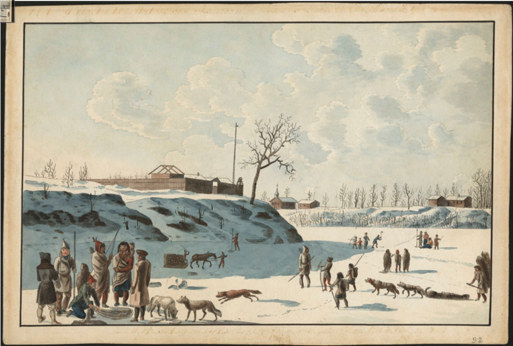
.... During the Red River Settlement in the 1810s to 1850s, the historic record shows that the east side of the red river (eg St B) was observed to be well forested with oak, elm, ash, linden, etc while the west side of the Red was forested for only a narrow strip along the red river — then nothing but open prairie....
And there is actually some visual evidence for what you are saying in this painting of The Forks from 1821.


https://www.bac-lac.gc.ca/
     
     
  #3839  
Old Posted Dec 22, 2020, 1:14 PM
AndersUlfBobby AndersUlfBobby is offline
Registered User
 
Join Date: Dec 2020
Location: Calgary
Posts: 1
Stock Yards

Anyone know what is going on with the old stock yards land on Marion? Any recent developments?
     
     
  #3840  
Old Posted Dec 22, 2020, 2:52 PM
robertocarlos robertocarlos is offline
Registered User
 
Join Date: Jul 2015
Posts: 820
The Best Western on Hargrave is being torn down very soon. The construction people have a large drill on site and they have drilled some holes already. I think they are putting up a 20 story building.
     
     
This discussion thread continues

Use the page links to the lower-right to go to the next page for additional posts
 
 
Closed Thread

Go Back   SkyscraperPage Forum > Regional Sections > Canada > Manitoba & Saskatchewan
Forum Jump


Forum Jump


All times are GMT. The time now is 2:47 PM.

     
SkyscraperPage.com - Privacy Statement - Top

Powered by vBulletin® Version 3.8.7
Copyright ©2000 - 2026, vBulletin Solutions, Inc.