Quote:
Originally Posted by HossC

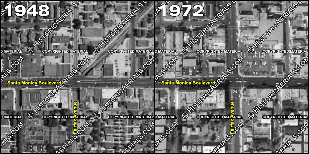
I had a quick look for angled views, but haven't found anything yet. Here are two views from Historic Aerials. The right-of-way is clear on the 1948 image (below), as well as the 1952 image. The path can still be seen on the 1964 image, although it's paved over. By 1972, there's no trace of the right-of-way. Note also how Fairfax has been widened between the two views.

Historic Aerials |
THANKS so much for this
HossC!
--In the '48 aerial it looks like there's a P.E. car stopped there between the two buildings at the corner.
--Across the street (northwest corner) it looks like some substantial buildings there and by '72 replaced by a restaurant or gas station. Now it looks more like the '48 aerial there.
I just found this photo on Hollywood photographs. It's small and a bit blurry. It shows this intersection in 1971, right before the '72 aerial, looking west on Santa Monica Blvd.

So, there's a Standard Gas station on that northwest corner.
And the P.E. tracks are readily visible.
--The southwest corner looks the same in both aerials and I'm wagering still is the same today.
--The southeast corner looks like a few minor differences in the aerials.
--The northeast corner is probably the same as in the '72 aerial now. I'm wondering, though, if anyone has a reason that the whole corner is raised, like on a hill? It's obviously not when the P.E. line ran through it, the photos show it's even with Santa Monica Blvd., but the location now--the parking lot, the shops and grocery store, they are all sitting well above the blvd.
Curious.
--And I did think Fairfax Ave. looked kind of narrow in the photos I posted and you confirmed it, as you mentioned, with the aerial, that it had been widened.


