HomeDiagramsDatabaseMapsForum About
     

Go Back   SkyscraperPage Forum > Photography Forums > Found City Photos

Reply

 
Thread Tools Display Modes
     
     
  #34141  
Old Posted Mar 17, 2016, 3:18 PM
HossC's Avatar
HossC HossC is offline
Registered User
 
Join Date: Aug 2013
Posts: 4,281


NCD beat me to it! I didn't find any pictures of parades, so here's a Saint Patrick's Day luncheon at the Biltmore Hotel in 1952. The photoset contains three images with two different speakers. The description lists those present as: Charles J. Horan (State Vice President, Hibernians); Jack Hayden (President of Hibernians); Michael Fanning (Postmaster); Archbishop J. Francis A. McIntyre; Chief William Parker. I have to say, it doesn't look like they're enjoying themselves much. Maybe it's because there's no Guinness .

For the non-Irish speakers out there, "Céad Míle Fáilte" literally translates as "A Hundred Thousand Welcomes".


USC Digital Library

Happy St Patrick's Day.
Reply With Quote
     
     
  #34142  
Old Posted Mar 17, 2016, 4:38 PM
ethereal_reality's Avatar
ethereal_reality ethereal_reality is offline
Registered User
 
Join Date: Feb 2008
Location: Lafayette/West Lafayette IN, Purdue U.
Posts: 16,550


Happy Saint Patrick's Day!
Reply With Quote
     
     
  #34143  
Old Posted Mar 17, 2016, 5:06 PM
Martin Pal Martin Pal is offline
Registered User
 
Join Date: Sep 2013
Posts: 2,496


LIKEWISE!

Our Gang

Last edited by Martin Pal; Mar 17, 2016 at 5:42 PM.
Reply With Quote
     
     
  #34144  
Old Posted Mar 17, 2016, 5:43 PM
Martin Pal Martin Pal is offline
Registered User
 
Join Date: Sep 2013
Posts: 2,496
Quote:
Originally Posted by ethereal_reality View Post
It doesn't say who bought it.


https://www.1stdibs.com/furniture/bu...s/id-f_396388/

Hopefully it stays in Los Angeles.

__

I was wondering that, too. The link is an online auction house. I found a 2010 Los Angeles Times article
talking about this being auctioned off by Los Angeles Modern Auctions (LAMA). Their listing (HERE) doesn't
say that it was sold. It was estimated at $80,000 - $100,000.

The Times article (HERE) says:

The entire glass mural is made up of 84 concrete-and-glass pieces, with the pyramid hanging down
from the center, and covered nearly 1,300 square feet when it was originally unveiled.


I guess this is the pyramid part:


"While each panel was composed to make up a larger design," the auction catalog notes, "they
can easily be assembled in smaller sections or used individually as coffee or dining tables."


Hmmm...yikes!
Reply With Quote
     
     
  #34145  
Old Posted Mar 17, 2016, 7:33 PM
MichaelRyerson's Avatar
MichaelRyerson MichaelRyerson is offline
Registered User
 
Join Date: Feb 2011
Location: Houston, Texas
Posts: 1,155
Quote:
Originally Posted by HenryHuntington View Post
Sorry I don't have an exact street address for you, ER, but the building is on the east side of Cahuenga Blvd. just north of Barham Blvd. The sequence of clips in the video were taken from the Barham Blvd. overcrossing of the Hollywood Freeway and look northward toward Universal City. The abandoned PE right-of-way is visible in the center divider, so Caltrans hadn't yet paved it to provide an additional traffic lane in each direction (ca. 1958, IIRC).

West side.
Reply With Quote
     
     
  #34146  
Old Posted Mar 17, 2016, 7:35 PM
MichaelRyerson's Avatar
MichaelRyerson MichaelRyerson is offline
Registered User
 
Join Date: Feb 2011
Location: Houston, Texas
Posts: 1,155
Quote:
Originally Posted by Noircitydame View Post
I came up with 1213 N. Highland as their original location, in 1948.
In 1949 they moved HQ up the street to 1239 N. Highland, until 1951
After that they were at 1435 N. Highland, until 1958 at least.

1948 lat 1957 lat
I don't believe any of those addresses gets us into Cahuenga Pass.
Reply With Quote
     
     
  #34147  
Old Posted Mar 17, 2016, 7:38 PM
MichaelRyerson's Avatar
MichaelRyerson MichaelRyerson is offline
Registered User
 
Join Date: Feb 2011
Location: Houston, Texas
Posts: 1,155
Quote:
Originally Posted by ethereal_reality View Post
I'm glad hosedagain re-posted these old screen-grabs.

If I remember correctly, no one was able to figure out where the Wax Seal Co. building was located.


Shall we give it another try?

here's the video (again)
https://www.youtube.com/watch?v=5JO5izL_3Jo
__

Looking north in Cahuenga Pass from the Barham Boulevard overpass, 1952

Wider view from the Barham bridge.

waterandpower.org
Reply With Quote
     
     
  #34148  
Old Posted Mar 17, 2016, 8:04 PM
HossC's Avatar
HossC HossC is offline
Registered User
 
Join Date: Aug 2013
Posts: 4,281
Quote:
Originally Posted by MichaelRyerson View Post
I don't believe any of those addresses gets us into Cahuenga Pass.
The 1956 CD has the "Way Seal Co" at 3230 Cahuenga Boulevard. I'm guessing that it should read "Wax Seal Co". They're gone from that location by 1960.
Reply With Quote
     
     
  #34149  
Old Posted Mar 17, 2016, 8:07 PM
HossC's Avatar
HossC HossC is offline
Registered User
 
Join Date: Aug 2013
Posts: 4,281
Thanks for all the follow-ups on the stained glass from Columbia Savings. I didn't know it had a hanging pyramid in the center, or that it had been saved.


-------------------


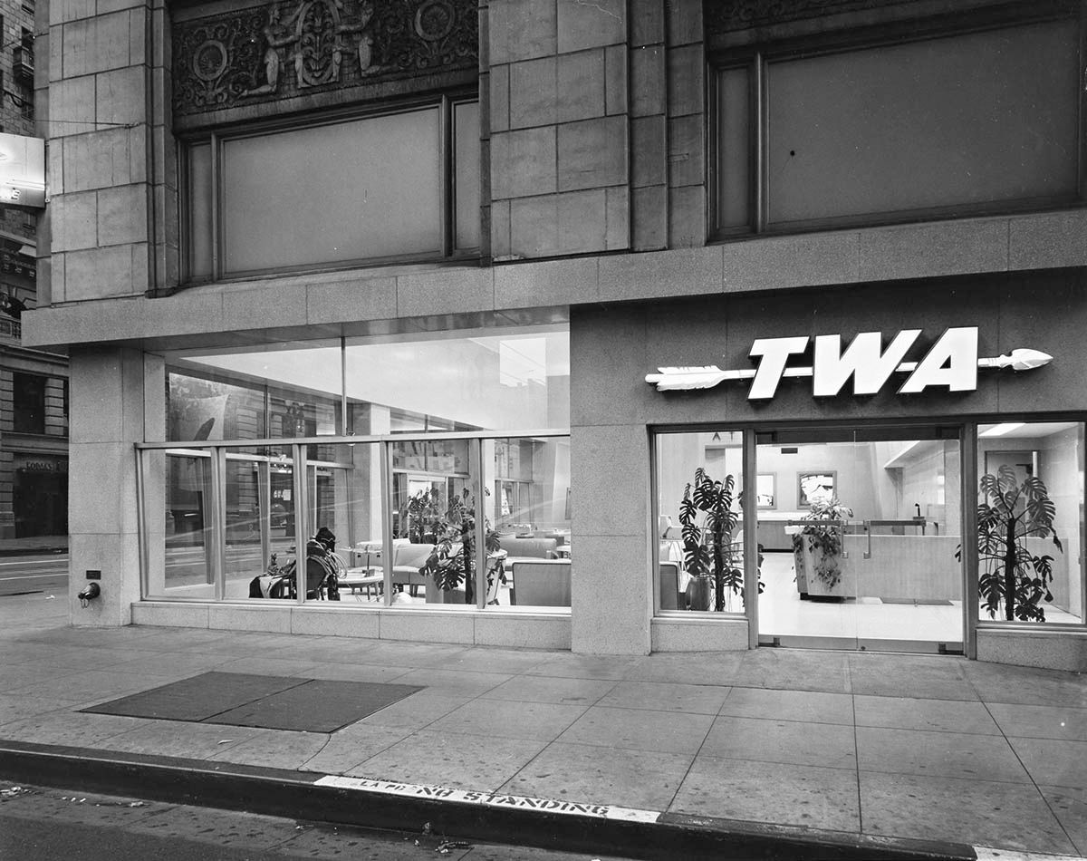
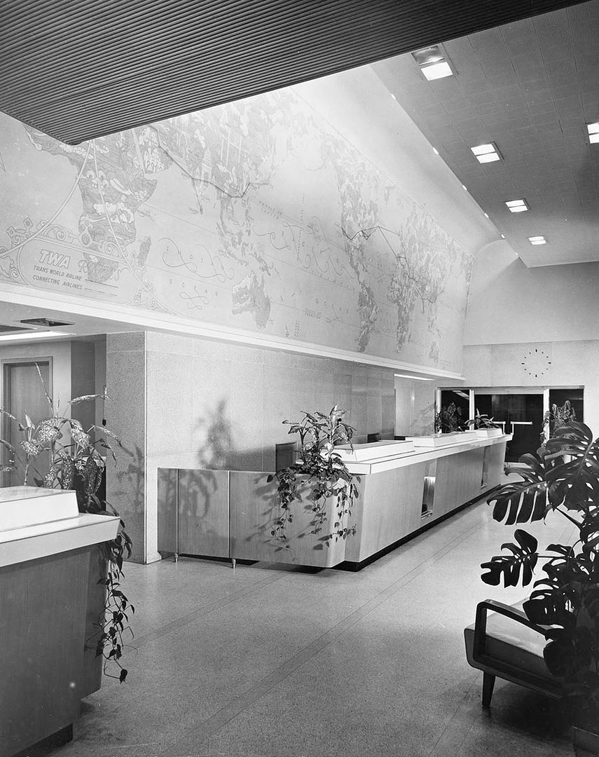
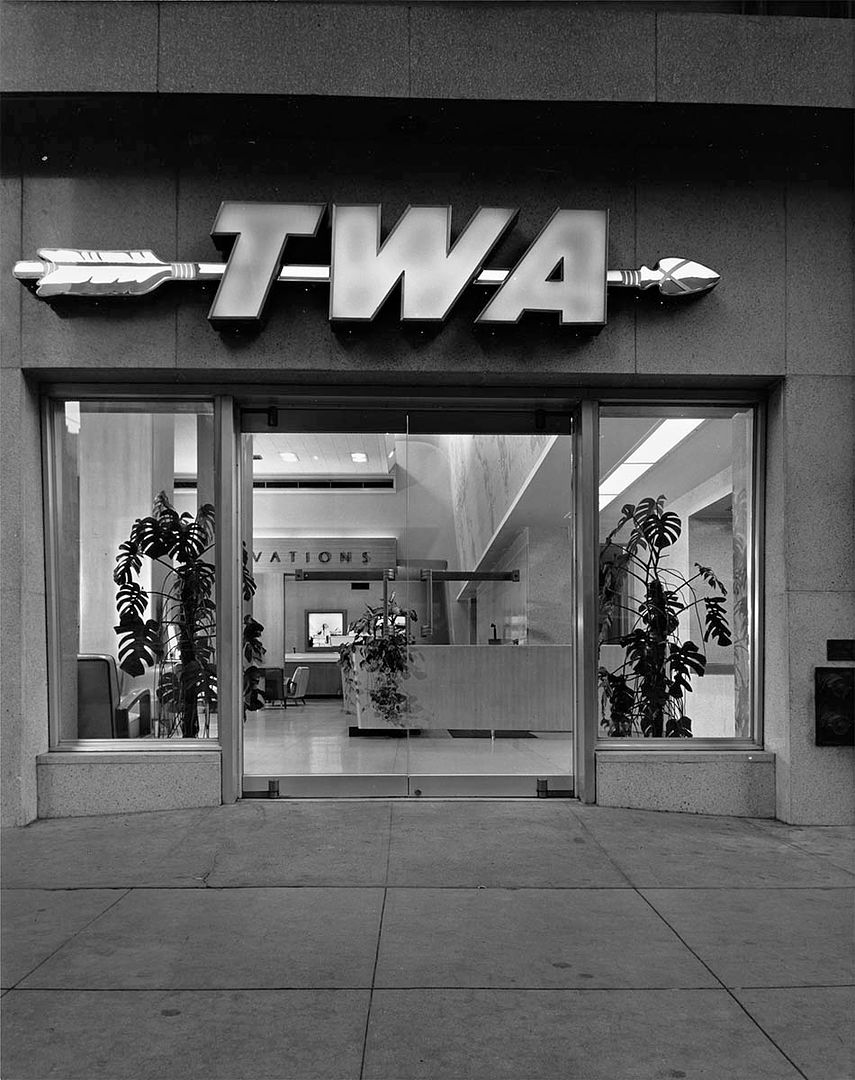
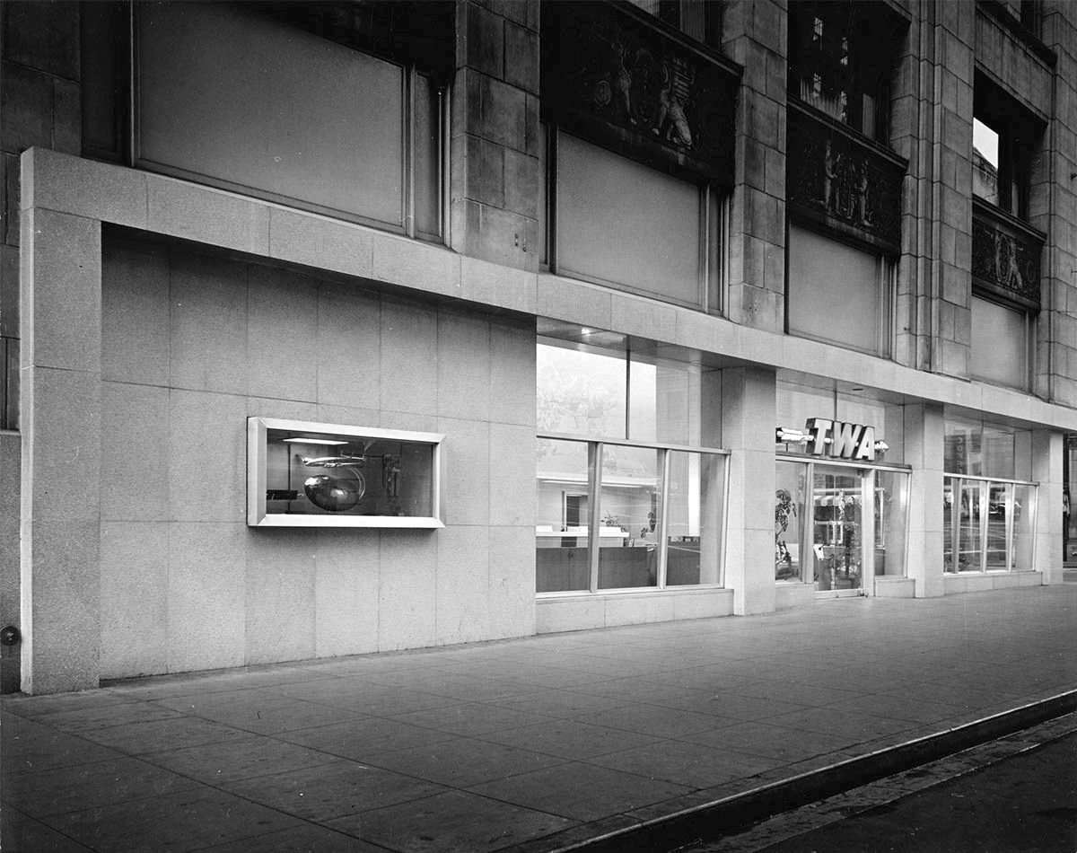
We're off traveling with today's Julius Shulman post - well, we can buy the tickets anyway! This is the downtown office of TWA in 1948. Comparing it to the American President Lines office from post #33631, it really must've been a glamorous event taking a boat or airplane in this era. This is "Job 138: Raymond Loewy, Trans World Airlines Office (Los Angeles, Calif.), 1948".


That model airplane looks slightly out of scale.


All the countries of the world, twice!


I think that the pictures at the back show the Acropolis, the Eiffel Tower, and a sphinx.


All from Getty Research Institute

When I looked for an address in the City Directories, I couldn't match the carvings in the images above. Then I found this undated picture which confirmed the location as 6th and Grand.
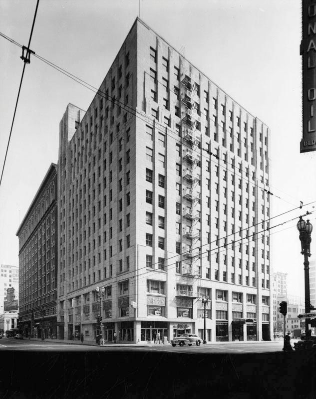

LAPL

The reason I didn't recognize the building is that the lower floors have been remodeled. The rest of it still looks like the photo above.
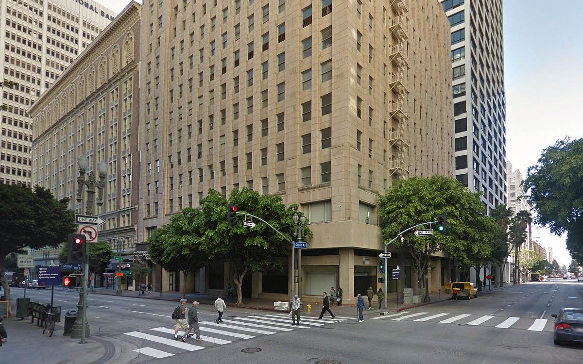

GSV
Reply With Quote
     
     
  #34150  
Old Posted Mar 17, 2016, 8:30 PM
ethereal_reality's Avatar
ethereal_reality ethereal_reality is offline
Registered User
 
Join Date: Feb 2008
Location: Lafayette/West Lafayette IN, Purdue U.
Posts: 16,550
Quote:
Originally Posted by MichaelRyerson View Post
There it is! -thanks M_R. That Quonset hut doesn't show up on the video.
___


'mystery' location.

Does anyone recognize this street corner?


old 2008 file of mine / probably found on eBay

__

Last edited by ethereal_reality; Mar 17, 2016 at 8:41 PM.
Reply With Quote
     
     
  #34151  
Old Posted Mar 17, 2016, 8:47 PM
ethereal_reality's Avatar
ethereal_reality ethereal_reality is offline
Registered User
 
Join Date: Feb 2008
Location: Lafayette/West Lafayette IN, Purdue U.
Posts: 16,550
'mystery' location #2.

Does another recognize this long two story building?


old 2008 file / eBay


-here's a closer look at the sign.


detail

LAFSCO?

__
Reply With Quote
     
     
  #34152  
Old Posted Mar 17, 2016, 8:57 PM
GaylordWilshire's Avatar
GaylordWilshire GaylordWilshire is offline
Registered User
 
Join Date: Nov 2009
Location: NYC
Posts: 3,706


The Shrine.... Great photo. The ancient streetcar belies the date-- there's a '58 Pontiac in view.
Reply With Quote
     
     
  #34153  
Old Posted Mar 17, 2016, 9:07 PM
GaylordWilshire's Avatar
GaylordWilshire GaylordWilshire is offline
Registered User
 
Join Date: Nov 2009
Location: NYC
Posts: 3,706
Quote:
Originally Posted by HossC View Post


That model airplane looks slightly out of scale.

Apparently the Constellation has a wingspan of nearly a yard-- this looks like one of its fleet-mates (same registration number):


More here: http://bit.ly/1S6UGFv
Reply With Quote
     
     
  #34154  
Old Posted Mar 17, 2016, 9:16 PM
MichaelRyerson's Avatar
MichaelRyerson MichaelRyerson is offline
Registered User
 
Join Date: Feb 2011
Location: Houston, Texas
Posts: 1,155
Too late for Monkey Island and too early for Wax Seal...

Looking north in Cahuenga Pass at the Barham Boulevard Bridge, ca.1947

Rather murky snapshot but really interesting look at the mid-40s traffic pattern at the northernmost reach of the new, improved Cahuenga roadway. Notice the northbound lanes, on the right, exit and cross over to Cahuenga Boulevard and continue into the San Fernando Valley on what then becomes Ventura Boulevard. The southbound traffic originates at the same terminus coming onto the southbound lanes at the onramp as they pass the Barham Boulevard bridge. cool. We're apparently a few years too late to see any part of Monkey Island and perhaps a couple of years before Wax Seal arrives.

www.rdforum.org
Reply With Quote
     
     
  #34155  
Old Posted Mar 17, 2016, 9:17 PM
HossC's Avatar
HossC HossC is offline
Registered User
 
Join Date: Aug 2013
Posts: 4,281
Quote:
Originally Posted by ethereal_reality View Post


detail

LAFSCO?
Quote:
Originally Posted by GaylordWilshire View Post


The Shrine.... Great photo. The ancient streetcar belies the date-- there's a '58 Pontiac in view.
GW beat me to this one. The L A Fraternal Supply Co (LAFSCO) was at 657 W Jefferson Boulevard.


GSV
Reply With Quote
     
     
  #34156  
Old Posted Mar 17, 2016, 9:51 PM
GaylordWilshire's Avatar
GaylordWilshire GaylordWilshire is offline
Registered User
 
Join Date: Nov 2009
Location: NYC
Posts: 3,706


I was curious about LAFSCO, but didn't find much. It moved to South Main in 1973--perhaps from the Shrine-- and may or may not still be open there...more or less at 3704.


LAT June 3. 1973 / GSV
Reply With Quote
     
     
  #34157  
Old Posted Mar 17, 2016, 10:42 PM
HossC's Avatar
HossC HossC is offline
Registered User
 
Join Date: Aug 2013
Posts: 4,281
Quote:
Originally Posted by MichaelRyerson View Post

Looking north in Cahuenga Pass at the Barham Boulevard Bridge, ca.1947

Rather murky snapshot but really interesting look at the mid-40s traffic pattern at the northernmost reach of the new, improved Cahuenga roadway. Notice the northbound lanes, on the right, exit and cross over to Cahuenga Boulevard and continue into the San Fernando Valley on what then becomes Ventura Boulevard. The southbound traffic originates at the same terminus coming onto the southbound lanes at the onramp as they pass the Barham Boulevard bridge. cool. We're apparently a few years too late to see any part of Monkey Island and perhaps a couple of years before Wax Seal arrives.

www.rdforum.org
Here's the progress in 1948. The left/right zig-zag for northbound drivers is still clearly visible as the new roadway edges around the corner, past the future site of Universal Studios. We've previously established that Monkey Island is shown on Historic Aerial's 1948 image (it's roughly dead center here), so it must be behind the trees in the view above.


Historic Aerials
Reply With Quote
     
     
  #34158  
Old Posted Mar 17, 2016, 11:06 PM
ethereal_reality's Avatar
ethereal_reality ethereal_reality is offline
Registered User
 
Join Date: Feb 2008
Location: Lafayette/West Lafayette IN, Purdue U.
Posts: 16,550
re: Shulman TWA photographs.

Quote:
Originally Posted by HossC View Post
That model airplane looks slightly out of scale.
Do you mean compared to the Earth? lol.


detail

-the earth looks a bit smooshed.


While looking at the scale-model in your next photo Hoss, I couldn't help but notice that other thingy.

detail


Do my eyes deceive me.....is that a saddle??
__


Thanks for locating the Shrine/streetcar slide GaylordWilshire. (and Hoss)
Reply With Quote
     
     
  #34159  
Old Posted Mar 17, 2016, 11:25 PM
ethereal_reality's Avatar
ethereal_reality ethereal_reality is offline
Registered User
 
Join Date: Feb 2008
Location: Lafayette/West Lafayette IN, Purdue U.
Posts: 16,550
I just found this on eBay.

"Bridge collapse, Santa Fe RRs Main Line into Los Angeles." [1941]


detail / http://www.ebay.com/itm/6BB821-RP-19...0AAOSwPc9WuoSz

Are we looking west or east?


-here's the whole photo.


http://www.ebay.com/itm/6BB821-RP-19...0AAOSwPc9WuoSz

That looks like my Uncle Hugh standing there.


additional information on the reverse.


__
Reply With Quote
     
     
  #34160  
Old Posted Mar 17, 2016, 11:51 PM
MichaelRyerson's Avatar
MichaelRyerson MichaelRyerson is offline
Registered User
 
Join Date: Feb 2011
Location: Houston, Texas
Posts: 1,155
Quote:
Originally Posted by ethereal_reality View Post
I just found this on eBay.

"Bridge collapse, Santa Fe RRs Main Line into Los Angeles." [1941]


detail / http://www.ebay.com/itm/6BB821-RP-19...0AAOSwPc9WuoSz

Are we looking west or east?


-here's the whole photo.


http://www.ebay.com/itm/6BB821-RP-19...0AAOSwPc9WuoSz

That looks like my Uncle Hugh standing there.


additional information on the reverse.


__

Looking northeast. That's the Lincoln Heights Jail back there. This is the RR bridge that leads into and out of the Cornfield.


Looking north from the SP cornfield railhead, ca.1938

Nice shot of the confluence of tracks at the north end of the 'Cornfield' (out-of-frame to the left) and the crossover to the Taylor Yard trestles here at Lincoln Heights and up ahead at the Arroyo Seco overpass. The white building on the east side of the 'unimproved' LA river is the Lincoln Heights jail.

unsourced

Last edited by MichaelRyerson; Mar 18, 2016 at 12:05 AM.
Reply With Quote
     
     
This discussion thread continues

Use the page links to the lower-right to go to the next page for additional posts

Reply

Go Back   SkyscraperPage Forum > Photography Forums > Found City Photos
Forum Jump


Forum Jump


All times are GMT. The time now is 12:52 AM.

     
SkyscraperPage.com - Archive - Privacy Statement - Top

Powered by vBulletin® Version 3.8.7
Copyright ©2000 - 2024, vBulletin Solutions, Inc.