HomeDiagramsDatabaseMapsForum About
     

Go Back   SkyscraperPage Forum > Regional Sections > Canada > Ontario > Ottawa-Gatineau > Ottawa Photos


Reply

 
Thread Tools Display Modes
     
     
  #321  
Old Posted Aug 20, 2015, 11:07 PM
rocketphish's Avatar
rocketphish rocketphish is offline
Planet Ottawa and beyond
 
Join Date: Feb 2009
Location: Greater Ottawa
Posts: 14,529
Quote:
Originally Posted by Norman Bates View Post
Yes, thanks for that. Seems like some prime real estate begging for development today. Could be made into a real high-end location. All it needs is a bridge and city services. Surely less expensive than carrying through the greenbelt.
Well... right now it's largely high-end swamp land. And the parts that aren't seasonally underwater are only a few feet above the river. It's basically an ever-shifting sandbank. And it's also completely within the City of Gatineau, so doesn't really come into play as an alternative to Ottawa's greenbelt-hopping sprawl issues.
Reply With Quote
     
     
  #322  
Old Posted Aug 23, 2015, 8:51 PM
J.OT13's Avatar
J.OT13 J.OT13 is offline
Moderator
 
Join Date: Mar 2012
Location: Ottawa
Posts: 28,594
John By's answer to the homeless problem

By Ron Corbett, Ottawa Sun
First posted: Saturday, August 22, 2015 05:03 PM EDT | Updated: Saturday, August 22, 2015 06:55 PM EDT


This is part 2 of Ron Corbett's summer series, The Dream of Bytown
I am standing at the corner of Cumberland Avenue and Rideau Street and I can just make out the eastern wall of the Salvation Army shelter on George Street, a block away.

There are people milling beside the shelter.

There is a wonky intersection there -- traffic changing from one-way to two-way -- and cars have backed up and ground to a halt.

Cumberland and Rideau would have been the southeast corner of the land given to John By in September 1826. Cumberland Avenue would have been a concession line, separating concessions C and D.

Almost immediately upon receiving this land, people moved next door to John By.

Reports of the day say it happened, -- the appearance of a large squatters' village -- almost overnight.

The Rideau Canal was the largest infrastructure project ever undertaken in British North America up to that time and people came looking for work. People who had travelled up river from Montreal and then camped out on the Cumberland line, hoping to find work.

Desperate people. Arriving by the boatload.

John By would have seen the campfires of the squatters' village as he looked down from the bluffs of what is today Parliament Hill.

It would have been mid-autumn of 1826. Winter only a few weeks away.

I cross Rideau Street and make my way toward the Salvation Army shelter, wondering if John By had been expecting the squatters. Is that why he was so decisive in dealing with the problem?

Or was he just afraid of winter?

When I reach the shelter I see there are more people on the street than I had realized. From Rideau Street I had seen only a fraction of the crowd gathered by the Salvation Army.

Looking down George Street now I see people stretching for a full city block, spilling into a parking lot next to the shelter, into a laneway next to the parking lot, sleeping on the sidewalks.

It is a modern-day squatters' village.

****

"There would have been several squatters' villages when John By was here," says Bruce Elliott, flipping through a book as he looks for a map.

"There would have been people living along the concession line, and on Letter O, which was just north of the land By was given.

"There would have been Corkstown, along the Rideau Canal, and another on the (Lebreton) Flats, by Richmond Landing."

Elliott is a history professor at Carleton University and the author of A City Beyond: A history of Nepean, birthplace of Canada's Capital, 1792-1990. It is a meticulously researched book that uses original source material Elliott discovered in many cases.

It is because of his work that we know the old township of Nepean (which became the city of Ottawa) had all of six homesteads when John By arrived in 1826.

"Not much here at the time," he says with professorial understatement, while continuing to look for his map.

"That's why the squatters' camps rather stood out."

Elliott is fascinated by the squatters camps and sometimes takes walking tours with his students, trying to find traces of the old camps in Lowertown. Or trying to imagine what it would have been like, to live in such a camp.

Some camps would have been little more than caves, dug into the banks of the Rideau Canal. Others would have resembled small villages.

"Here it is," he says finally, and I find myself looking at an 1847 map from his book, showing a squatters' camp on Letter O, what is today the northern tip of Lowertown.

Overtop the map has been dropped to the grid of a proposed sub-division. The grid is pretty much how the area looks today.

"Look at how many people were living there," says Elliott.

"All those houses would have been squatters. There were stables and stores as well. There was even a school."

Elliott discovered the map in a registry office more than 25 years ago. You can still hear the amazement in his voice, as he looks at what John By allowed the squatters to build.

***

The Salvation Army shelter is one of three in the area, the other two being the Ottawa Mission and the Shepherds of Good Hope.

All three shelters are directly on, or within a block, of the old Cumberland concession line.

This is not an accident. Or happenstance. It is history we have forgotten. The shelters in Ottawa have all been built where the old squatters' camps once stood.

"Homelessness is a problem that seems to concentrate in this area, and I don't think that will ever change," says Peter Tilley, executive director of the Ottawa Mission.

"We have tried to de-centralize it, but we have had only limited success, in my opinion.

"There is a pull to this area that I don't think you can fight. Most of the support services are here. The community contacts are here. And historically, this is always where the homeless have come in Ottawa." Going back, it appears, to day two.

The Ottawa Mission does not go back that far, but it was established more than a century ago -- in 1906 -- and it has never been in jeopardy of closing its doors.

The other two shelters are just as busy.

If history teaches us, as Tilley argues, that the Market and Lowertown will always be the destination for the homeless in Ottawa, do three bustling shelters in the area also tell us the problem is never going away?

"I think it's time for some new approaches, I certainly think that," says Tilley.

"There needs to be more personal responsibility, I think. We have used rent supplements recently, with great success, to re-integrate some of our long-term clients, "I don't think you can wait for government to kick in a lot of money. Give people the chance to live independently, to live in dignity, and you can usually get good outcomes."

***

In some ways it is unfair, to suggest that John By's solution to the homeless problem in 1826 can be tried in Ottawa today.

I take a look down George Street and realize that. John By did not have to deal with crack cocaine, for one.

But it is still interesting to note that By's solution is rather in vogue today.

He encouraged home ownership, for one. He did not like "warehousing" indigent people, or leaving them to fend for themselves.

And people should work. This was also something he believed in.

If John By thought the scores of people arriving in Ottawa had no intention of working -- would not contribute to the new village, or to the grand undertaking about to begin -- he would have left Lowertown as the uninhabited cedar bog he found it.

People needed to work as much as they needed a home. The relationship was so intrinsic, By would have had trouble imagining one without the other.

I'm thinking about this as I make my way down George Street. Although there is a large crowd on the street, it is not homogenous.

Standing nearest the front doors of the Salvation Army shelter are the timid and uncertain. Men who neither talk nor move. Who seem almost shell-shocked.

Next to them are old men in wheelchairs and young men who pace in tight circles, not wanting to take up too much space on the sidewalk, not wanting to push boundaries.

After that the crowd gets louder and more boisterous, an almost kinetic force that seems to build the further you get from the front doors.

There are drug deals happening in the parking lot next to the shelter. Behind a parked van I see a young woman sticking a needle in her arm. Three men are lighting crack pipes while leaning against a chain link fence on the other side of the parking lot, where the Honest Lawyer pub used to be.

It is mid-afternoon. Tuesday.

It may be unfair to compare John By's solution of 1826 to the homeless problem of today.

Although it is fair comment to say he never would have let the Byward Market get like this.

And I walk away wondering when that changed.

[email protected]

http://www.ottawasun.com/2015/08/22/john...ys-answer-to-the-homeless-problemoneplan

Reply With Quote
     
     
  #323  
Old Posted Aug 24, 2015, 3:22 AM
rocketphish's Avatar
rocketphish rocketphish is offline
Planet Ottawa and beyond
 
Join Date: Feb 2009
Location: Greater Ottawa
Posts: 14,529
Ottawa's first federal election left traces on the city

Phil Jenkins Phil Jenkins
Published on: August 23, 2015 | Last Updated: August 23, 2015 7:00 AM EDT


In a couple of years, Ottawa will be party central (in both the political and celebrative sense) when we mark 150 years since we began assembling the provinces into a federation. The year 1867 was also the year Ottawa was the epicentre of the Dominion of Canada’s first general election, the writ for which was dropped on Aug. 6. A month and a bit earlier, at midnight on June 30, the bells had started ringing in the churches of Ottawa and across the confederated provinces to celebrate the birth of a democracy.

The day after the writ was dropped, the voting and the counting of them began. Assembling the votes so that they could be counted and the results relayed to Ottawa was not easy in a country where four-fifths of the population lived in between the cities, not in them. It wasn’t until Sept. 20 that the brand new Governor General, in the person of Lord Monck, was able to declare John A. Macdonald the prime minister. The freshly elected first batch of MPs met on Parliament Hill, with the paint still fresh on the walls, for the first time on Nov. 6.

In Ottawa of 1867, the entire population amounted to almost exactly the average attendance at Senators games last year — 18,247. Out of those 18,000, who could actually vote in the first general election? The eligibility criteria varied in detail then from province to province, but you needed to not be at least three things; female, under 21 and something other than a British subject. There were also conditions related to money, in the form of property or annual income. If you made more than $250 a year in Ontario (the former Upper Canada) you were good to go to the polling station. (That’s me out, then.) Once at the polling station you voted with your mouth, not a pencil or by touching a screen, announcing your vote to all and sundry. The possibilities for intimidation and bribery were rife, and were entertained. The attack ads and rhetoric in those days, on the stump and in the pages of the Citizen, made today’s mudballs seem like soap bubbles.

When all the results were finally in, the winner in the city of Ottawa was Joseph Merrill Currier, a member of the coalition Liberal-Conservative party. (Two words you don’t often see hyphenated these days.) Currier was our sole MP, there being only one riding in Ottawa until 1872.

Currier was American born, arriving in Canada around 1837 in his late teens. By the time of the general election he had been a busy man, hooking into the timber trade with mills in Manotick, New Edinburgh and launching a start-up lumber business in Hull with Alonzo Wright. His business in Manotick was short-lived; when he brought his second wife, Annie, to the mill for the first time, in 1863, she was killed in an industrial accident when her frock caught in machinery. Joseph never went near Manotick again.

Then as now, Ottawa men whose deep pockets were full of timber money went into politics. Currier stepped on the first rung of the political ladder when he became a city councillor for By Ward in the early 1860s, and then went one step up in 1863 by becoming a MLA. A year after he was elected, he built a home for his third wife, a member of the Wright family. The address was 24 Sussex.

He also found time during his tenure as our MP to be president of the company that owned and printed the Citizen, be involved in a couple of railway companies, and, in 1877, forced to resign from Parliament by the opposition on a technicality when it was discovered that Joseph the MP had been doing business with Joseph the entrepreneur. He was re-elected within the month. A year later his mill in Hull burnt down and he was bankrupt. His fellow Conservatives came to his aid to help him meet his expenses.

Currier ceased to be our MP in 1882, by virtue of not running in that election. He promptly became the city postmaster and delivered that post till his death two years later, while away in New York. He is buried, alongside many who sat with him then and since, in Beechwood Cemetery.

Phil Jenkins is an Ottawa writer. Email [email protected].

http://ottawacitizen.com/news/politics/ottawas-first-mp-left-traces-on-the-city
Reply With Quote
     
     
  #324  
Old Posted Sep 2, 2015, 12:35 AM
DubberDom DubberDom is offline
Registered User
 
Join Date: Dec 2007
Location: Ottawa
Posts: 201
Is that an on-ramp? from just east of Bronson before Kent exit? That is sadly missing, the only onramp east of Parkdale going east is at the Rideau Canal
Reply With Quote
     
     
  #325  
Old Posted Sep 2, 2015, 2:00 AM
lrt's friend lrt's friend is offline
Registered User
 
Join Date: Dec 2006
Posts: 12,750
Quote:
Originally Posted by DubberDom View Post
Is that an on-ramp? from just east of Bronson before Kent exit? That is sadly missing, the only onramp east of Parkdale going east is at the Rideau Canal
I think it was already closed in this picture. If you look at the lanes, you could not have safely entered the Queensway.
Reply With Quote
     
     
  #326  
Old Posted Sep 2, 2015, 2:06 AM
HighwayStar's Avatar
HighwayStar HighwayStar is offline
Registered User
 
Join Date: Jul 2014
Location: PHX (by way of YOW)
Posts: 1,200
Quote:
Originally Posted by lrt's friend View Post
I think it was already closed in this picture. If you look at the lanes, you could not have safely entered the Queensway.
You're right.... it looks like a chain link fence at the entrance to the ramp... and even then there appears to be an accident right when traffic would merge
Reply With Quote
     
     
  #327  
Old Posted Sep 2, 2015, 7:46 AM
Norman Bates Norman Bates is offline
Living With My Mother
 
Join Date: Feb 2009
Posts: 1,026
That on ramp at Bronson has been closed a very long time.

I started going past there in 1982 and access from Isabella was closed by a chain link fence then - but I remember seeing the ocassional police car backed into that slot on the queensway side waiting for a call.

There was major work completed in 1986 to widen the Queensway and I think that's when the last vestiges of that ramp were hidden behind the corrogated steel sound barriers that we have today.
Reply With Quote
     
     
  #328  
Old Posted Sep 2, 2015, 1:53 PM
Acajack's Avatar
Acajack Acajack is offline
Gros Méchant Loup
 
Join Date: Aug 2006
Location: Province 2, Canadian Empire
Posts: 72,949
Quote:
Originally Posted by Norman Bates View Post
That on ramp at Bronson has been closed a very long time.

I started going past there in 1982 and access from Isabella was closed by a chain link fence then - but I remember seeing the ocassional police car backed into that slot on the queensway side waiting for a call.

There was major work completed in 1986 to widen the Queensway and I think that's when the last vestiges of that ramp were hidden behind the corrogated steel sound barriers that we have today.
If you look at Chamberlain Ave. east of Bronson Google Earth you can see an indentation in the curb on the left-hand side where the ramp used to branch off from Chamberland.

You can also see part of the ramp on the Percy St. overpass of the Queensway. It's separated from the Queensway itself by a wall or something by a small patch of roadway is still visible.
__________________
Loin des yeux, loin du coeur.
Reply With Quote
     
     
  #329  
Old Posted Sep 10, 2015, 8:56 PM
J.OT13's Avatar
J.OT13 J.OT13 is offline
Moderator
 
Join Date: Mar 2012
Location: Ottawa
Posts: 28,594
Jackson Building on Urbsite:


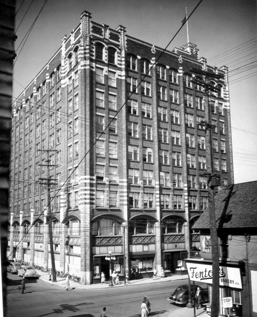
The building once had a roof top garden: "Surmounting the ninth floor is the pent house for the elevator shafts. This is artistically worked into the design of the building. The roof garden itself is a sight worth the trip in the elevator to see. It is bordered with flower boxes containing all manner of flowering plants, while here and there in huge tubs are trees and shrubbery. At the west end, a raised platform with concave roof and back is provided for an orchestra, ensuring that the sound of the music is carried to all parts of the roof. On the south side a raised terrace extends the full length of the roof, and here the merrymakers halt for refreshments. From all the tables an unobstructed view of the dancers on the main floor can be obtained. The place is brilliant with clusters and row upon row of smaller lights."

http://urbsite.blogspot.ca/2015/09/the-jackson-buildings-many-lives.html
Reply With Quote
     
     
  #330  
Old Posted Sep 11, 2015, 3:31 PM
MoreTrains MoreTrains is offline
Registered User
 
Join Date: Oct 2014
Posts: 858
Did they keep the building and clad it in an ugly facade or did they rebuild a 9 floor building on the same spot? If it is just a facade, it would really behoove the owner to remove it so the building could be seen for the beauty it once was!
Reply With Quote
     
     
  #331  
Old Posted Sep 11, 2015, 4:02 PM
J.OT13's Avatar
J.OT13 J.OT13 is offline
Moderator
 
Join Date: Mar 2012
Location: Ottawa
Posts: 28,594
It was a complete gut job to the bones done in the 60s. Only the foundations and frame are original to the building.
Reply With Quote
     
     
  #332  
Old Posted Sep 11, 2015, 6:08 PM
Urbanarchit Urbanarchit is offline
Registered User
 
Join Date: Jun 2013
Location: Ottawa
Posts: 1,927
I think it was because the building's façade was damaged when the movie theatre exploded and destroyed the building beside it (the gap on Bank between Laurier and Slater). The government hired an architect to reclad it, but after construction started the pulled the plug in the building, leading to the architect having to use his own money to finish the building. He chose a cheaper façade as a result and went bankrupt.

One of the blogs in Centretown explained what happened here. Unfortunate.
Reply With Quote
     
     
  #333  
Old Posted Sep 12, 2015, 1:27 AM
lrt's friend lrt's friend is offline
Registered User
 
Join Date: Dec 2006
Posts: 12,750
There was a lot of talk about the Jackson Building when I was growing up and the problems that they had with it after the explosion.

I am amazed that the site of the Odeon Theatre has never been redeveloped. Is there an issue with that piece of land?
Reply With Quote
     
     
  #334  
Old Posted Sep 12, 2015, 4:13 PM
J.OT13's Avatar
J.OT13 J.OT13 is offline
Moderator
 
Join Date: Mar 2012
Location: Ottawa
Posts: 28,594
Quote:
Originally Posted by Urbanarchit View Post
I think it was because the building's façade was damaged when the movie theatre exploded and destroyed the building beside it (the gap on Bank between Laurier and Slater). The government hired an architect to reclad it, but after construction started the pulled the plug in the building, leading to the architect having to use his own money to finish the building. He chose a cheaper façade as a result and went bankrupt.

One of the blogs in Centretown explained what happened here. Unfortunate.
According to the Urbsite post, they only invested in a 1 million Band-Aid solution after the explosion across the street and decided to do the overhaul a few years later. The architect went bankrupt because he assumed the whole building was of steel frame construction, based on the 1941 annex plans. He had to re-calculate everything at his own expense when they discovered the original 1920 building had a concrete frame.
Reply With Quote
     
     
  #335  
Old Posted Sep 16, 2015, 7:48 PM
drawarc's Avatar
drawarc drawarc is offline
Registered User
 
Join Date: Jul 2001
Posts: 471
Reply With Quote
     
     
  #336  
Old Posted Sep 16, 2015, 11:03 PM
J.OT13's Avatar
J.OT13 J.OT13 is offline
Moderator
 
Join Date: Mar 2012
Location: Ottawa
Posts: 28,594
Quote:
Originally Posted by drawarc View Post
Bummer. That would have been awesome.
Reply With Quote
     
     
  #337  
Old Posted Sep 21, 2015, 2:53 AM
rocketphish's Avatar
rocketphish rocketphish is offline
Planet Ottawa and beyond
 
Join Date: Feb 2009
Location: Greater Ottawa
Posts: 14,529
Cummings Island: A former commercial hub now sits empty

Bruce Deachman, Ottawa Citizen
Published on: September 20, 2015 | Last Updated: September 20, 2015 8:15 PM EDT


It’s a tiny thing, Cummings Island, sitting in the middle of the Rideau River a dozen metres south of the current Cummings Bridge joining Rideau Street to Montreal Road. Just under an acre in size, the island could be circumnavigated by a halfway decent swimmer in only a couple of minutes, even after a big meal.

Viewed from the shore, signs of past human habitation are few: at its north end, pilings of squared stones are all that remain of an earlier Cummings Bridge, built in 1891 and the last of a few similarly named spans that connected Sandy Hill and Ottawa with what eventually became known as Vanier.

On the island’s opposite end, a concrete abutment still protects the island from the ice floes that each spring crash by on their way to the Rideau Falls.


Between these man-made bookends are trees and scrubland that offer no hint of the bustle of life and commerce that once flourished on the island. In its time, Cummings Island was a significant going concern, hosting a general store, post office, flour mill, carriage manufacturer and the first telephone in Gloucester. “It was so busy, you could have counted 75 carriages on the island at one time,” notes Vanier historian Raymond Hotte.

Louis Riel is believed to have stopped by while passing through, while another man, Peter Kinwood, accidentally drowned there. One person was buried on the island, while others were married there.

The island’s initial namesake, Charles Cummings, first settled the area and built a cabin for his family on the island in 1840, and for a few years operated a ferry service carrying passengers across the river.

A successful businessman, Cummings obtained squatter’s rights to the island from John Scott four years earlier. A wooden bridge joining Bytown with Janeville (later Eastview, and still later Vanier), in Gloucester had already been started, and abandoned. That bridge, according to one account, consisted simply of abutments with stringers laid on them. “For several years the stringers were uncovered by either logs or planks, and steady nerves were required to walk across them; only one death from drowning being recorded.”


Cummings eventually completed the bridge, but hardly lived long enough to enjoy it much. He died in 1847, at just 47, and was buried on the island.

To help make ends meet, his widow, Frances Spratt, opened a small store in their cabin, while Robert, then just 14, continued his carriage-making apprenticeship, first in Ottawa, moving later to Southern Ontario to work as a foreman. When he returned in 1864, he bought the island from the Crown for $4, eventually building a large brick house and store to replace the cabin, while also constructing a flour mill and a building out of which be built carriages. The store also served as post office, and had Janeville’s first telephone.

In 1891, the City of Ottawa built a new, steel bridge over the island, naming it Bingham’s Bridge — after former Ottawa mayor Samuel Bingham — but the name didn’t last: disgruntled demolition workers removed the new sign and threw it into the river.

On a June day the following year, meanwhile, Robert’s 24-year-old daughter Frances Adelaide Cummings, stood on the island and, surrounded by friends and family, said “I do” to Hugh Howard Rowatt.

In 1921, the City of Ottawa built a new bridge 12 metres downstream from the island. A year later, the City bought the island and buildings from Robert’s sons, Bill and Clark Cummings, for $30,000 and demolished the store. Bill relocated the store to the site now occupied by the Tim Hortons at Montreal Road and the Vanier Parkway, while Clark established Vanier’s first service station, in the site of the current Shell station at Montreal and River roads.

Cummings Island has remained abandoned since 1923.

[email protected]

http://ottawacitizen.com/news/local-news/cummings-island-a-former-commercial-hub-now-sits-empty
Reply With Quote
     
     
  #338  
Old Posted Sep 21, 2015, 2:14 PM
lrt's friend lrt's friend is offline
Registered User
 
Join Date: Dec 2006
Posts: 12,750
I wrote a story about the 1891 construction of 'Bingham's Bridge'. It was almost comical about the dispute over the naming of the bridge. It wasn't demolition workers that were involved, but ordinary residents. This bridge connected Ottawa and Gloucester at the time and the Cummings family were very important in business and Gloucester politics. Robert Cummings had been the Reeve. To rename the bridge after a lowly Ottawa councillor (he became mayor later) without consultation was unacceptable. As a result, a metal sign installed by the city to denote the new name of the bridge and to rub it into the noses of Gloucester residents and politicians was quickly removed and thrown into the river. The 1891 metal bridge was poorly built from day one and it had to be closed to vehicle traffic during World War I. The bridge had already become unsafe. A new bridge became critical but its relocation to bypass the island was to facilitate streetcars to run onto Montreal Road. Another extensive dispute followed with Eastview council throughout the 1920s over proposed streetcar fares and as a result, streetcar service was never extended onto Montreal Road.

The Cummings Island post office was important as it served most of the north half of Gloucester Township. Most war veterans from north Gloucester during the first World War had a Cummings Bridge address.
Reply With Quote
     
     
  #339  
Old Posted Sep 25, 2015, 8:03 PM
drawarc's Avatar
drawarc drawarc is offline
Registered User
 
Join Date: Jul 2001
Posts: 471
Quote:
Originally Posted by J.OT13 View Post
Bummer. That would have been awesome.
Agreed, would have been much more impressive than the mishmash of buildings in the area.
Reply With Quote
     
     
  #340  
Old Posted Sep 25, 2015, 9:55 PM
lrt's friend lrt's friend is offline
Registered User
 
Join Date: Dec 2006
Posts: 12,750
It looks like it was an overly ambitious project for the time. Times and market conditions changed resulting in the subsequent phases not following the same design model. I wonder if land was sold off to other developers resulting in the design changes.
Reply With Quote
     
     
This discussion thread continues

Use the page links to the lower-right to go to the next page for additional posts
 
 
Reply

Go Back   SkyscraperPage Forum > Regional Sections > Canada > Ontario > Ottawa-Gatineau > Ottawa Photos
Forum Jump


Forum Jump


All times are GMT. The time now is 7:29 PM.

     
SkyscraperPage.com - Privacy Statement - Top

Powered by vBulletin® Version 3.8.7
Copyright ©2000 - 2026, vBulletin Solutions, Inc.