I've seen this photo before, but it just came up on local media again:
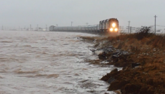
It shows the
Ocean Limited passing over the Tantramar Marsh between Sackville NS and Amherst NS during a storm driven king tide a number of years ago.
You can see the ocean literally lapping on the railroad ties.

What makes this alarming is that the railway embankment sits on top of the dike system keeping the Marsh from being inundated. The Trans Canada Highway lies immediately inland of the railway embankment and is at a lower level than the embankment.
The railway embankment came within a whisker of being overtopped during that storm event, and if the dyke system had failed, then the CNR mainline
and the TCH to NS (and NL) would have been inundated. Billions of dollars of commerce would have been at risk.
Sea level rise is staring us in the face. This photo gives me the willys.
The Federal and (relevant) provincial governments have just completed a study on this with several scenarios to bolster the dykes, but the cost will be $250-300M. There is no way around it. The work has to be done, but the fix will take 10-12 years or so.
We just have to pray that we don't have another Saxby Gale in the meantime..........


 Prev
Prev


 Linear Mode
