HomeDiagramsDatabaseMapsForum About
     

Go Back   SkyscraperPage Forum > Photography Forums > Found City Photos

Reply

 
Thread Tools Display Modes
     
     
  #61721  
Old Posted Jun 16, 2024, 8:38 PM
ethereal_reality's Avatar
ethereal_reality ethereal_reality is online now
Registered User
 
Join Date: Feb 2008
Location: Lafayette/West Lafayette IN, Purdue U.
Posts: 16,427


AlvaroLegido, by slightly shaking a stereoview image via a gif you get an idea of the 3 dimensional quality.

Here's an example.

People standing by a Ford automobile / location unknown

It's basically the same idea behind the more recent View-Master.

.

Last edited by ethereal_reality; Jun 16, 2024 at 8:51 PM.
Reply With Quote
     
     
  #61722  
Old Posted Jun 17, 2024, 8:56 PM
ethereal_reality's Avatar
ethereal_reality ethereal_reality is online now
Registered User
 
Join Date: Feb 2008
Location: Lafayette/West Lafayette IN, Purdue U.
Posts: 16,427
.

Ismaelmub, first you have to upload your photographs to a photo hosting site and go from there.

I use imageshack
_________________


Guess what folks. I have a mystery location for this afternoon.

I happened upon this slide of a Richfield and Mobil gas station this morning on eBay. I'm pretty sure it's new to NLA.


eBay

Does this area look familiar to anyone?

.
Reply With Quote
     
     
  #61723  
Old Posted Jun 17, 2024, 10:19 PM
ethereal_reality's Avatar
ethereal_reality ethereal_reality is online now
Registered User
 
Join Date: Feb 2008
Location: Lafayette/West Lafayette IN, Purdue U.
Posts: 16,427
Here's another slide from the same time period.


eBay


.

Last edited by ethereal_reality; Yesterday at 8:26 PM.
Reply With Quote
     
     
  #61724  
Old Posted Jun 17, 2024, 11:50 PM
riichkay riichkay is offline
Registered User
 
Join Date: Jan 2016
Posts: 248
Re the above photo with the 2 gas stations, I think this is the curve at Highland and Franklin...


....just beneath the canopy of the Richfield station I believe you can see a sliver of the Hughes Market that was at the n.e. corner of Highland/Franklin for many years.
Reply With Quote
     
     
  #61725  
Old Posted Yesterday, 6:12 PM
Martin Pal Martin Pal is offline
Registered User
 
Join Date: Sep 2013
Posts: 2,471


When I first saw that photo the view felt oh so familiar and you confirmed that with your identification riichkay. With the road that converges there that 2-Way Signal sign is another confirmation.

In that photo, someone has knocked over one of the cones in the road.
Reply With Quote
     
     
  #61726  
Old Posted Yesterday, 8:38 PM
ethereal_reality's Avatar
ethereal_reality ethereal_reality is online now
Registered User
 
Join Date: Feb 2008
Location: Lafayette/West Lafayette IN, Purdue U.
Posts: 16,427
.
Thanks for figuring out the location of the gas stations, riichkay. I appreciate it.


A news photo just popped up on eBay of an aerial ambulance at LA Eastside Airport in 1933.


eBay


Info.


But I don't recall any airport between Los Angeles and Whittier.

.
Reply With Quote
     
     
  #61727  
Old Posted Today, 12:28 PM
odinthor's Avatar
odinthor odinthor is offline
Registered User
 
Join Date: May 2015
Posts: 1,335


e_r, here is a 1934 list of the less-known airports of the L.A. area:


LA Times, 1/2/1934

But then . . .


LA Times, 3/22/1937
Reply With Quote
     
     
  #61728  
Old Posted Today, 1:15 PM
Mackerm's Avatar
Mackerm Mackerm is online now
Registered User
 
Join Date: Jul 2020
Location: San Gabriel Valley
Posts: 193
Been there done that. This post from bygone times mentions Los Angeles Eastside Airport, shown at the bottom near the intersection of Telegraph Rd. and Church Rd.
Quote:
Originally Posted by ethereal_reality View Post
I meant to post this map in post #903, along with the photo of Vail Airport.


unknown

Above: As you can see there were actually three airports in the area ;
the tiny Los Angeles Eastside Airport and the Telegraph Atlantic Airport.
But I am confused, because this article lists a similarly-named airport with a different address, 800 E. Whittier Blvd, Montebello:


eBay
Reply With Quote
     
     
  #61729  
Old Posted Today, 6:26 PM
odinthor's Avatar
odinthor odinthor is offline
Registered User
 
Join Date: May 2015
Posts: 1,335


The last third of this page (link below) deals with Vail Field and, more to our purpose, the nearby Montebello Airport (opened in 1940) at Telegraph Road and Sycamore, which latter airport became known as East Los Angeles Airport, evidently also called Eastside Airport (different from the by-then closed earlier Eastside Airport of the 1930s on Whittier Blvd. mentioned in my earlier posting).

http://www.airfields-freeman.com/ca/...htm#montebello
Reply With Quote
     
     
  #61730  
Old Posted Today, 10:12 PM
ethereal_reality's Avatar
ethereal_reality ethereal_reality is online now
Registered User
 
Join Date: Feb 2008
Location: Lafayette/West Lafayette IN, Purdue U.
Posts: 16,427
Hmm. .so there were two named Eastside?

Thanks odinthor and Mackerm. I appreciate your help. (I had obviously forgotten about the earlier post)

.

Last edited by ethereal_reality; Today at 10:24 PM.
Reply With Quote
     
     
  #61731  
Old Posted Today, 10:49 PM
GatoVerde's Avatar
GatoVerde GatoVerde is online now
Registered User
 
Join Date: Dec 2013
Location: Los Angeles
Posts: 111
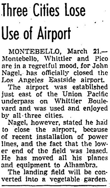
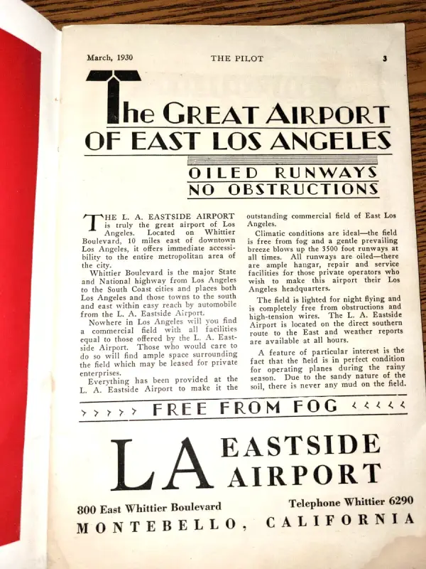
I found on ebay an item related to the Los Angeles Eastside Airport:

1) A copy of The Pilot, March, 1930 publication, which lists the address as 800 East Whittier Blvd. The would place the airport on the SW corner of what is now Whittier and Paramount blvds.
https://www.ebay.com/itm/195707962156

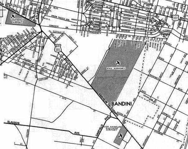
I also found an flight map showing the airport in Montebello as being in between the Rio Hondo and the San Gabriel River.

The map is credited as being from August 1933 LA Sectional Aeronautical Chart, and was found on the webpage created by Paul Freeman: "Abandoned & Little-Known Airfields: California: East Los Angeles Area": http://www.airfields-freeman.com/ca/...E.htm#rosemead

Map:
http://www.airfields-freeman.com/ca/..._m5a5c78f6.jpg

The airport site is now a shopping mall, but previously it was the Paramount Drive-In Theater, a venue I was fully acquainted with in days past.
Reply With Quote
     
     
End

Reply

Go Back   SkyscraperPage Forum > Photography Forums > Found City Photos
Forum Jump


Forum Jump


All times are GMT. The time now is 11:26 PM.

     
SkyscraperPage.com - Archive - Privacy Statement - Top

Powered by vBulletin® Version 3.8.7
Copyright ©2000 - 2024, vBulletin Solutions, Inc.