HomeDiagramsDatabaseMapsForum About
     

Go Back   SkyscraperPage Forum > Regional Sections > Canada > Manitoba & Saskatchewan


Reply

 
Thread Tools Display Modes
     
     
  #141  
Old Posted Jul 11, 2018, 3:27 AM
buzzg buzzg is offline
Registered User
 
Join Date: Apr 2013
Posts: 7,810
Quote:
Originally Posted by h0twired View Post
Any word on when the bike lanes on McDermot/Bannatyne are going to be done?

Its a disaster right now trying to navigate a bike down McDermot in traffic at the end of the work day.
Bannatyne from Main to Adelaide is open now. Seems like most of the work on McDermot west of Main is done, should be open soon. Still lots of underground work going on east of Main, but the construction on Waterfront (rebuilding roundabout/intersections & connecting to trail) appears to be nearing completion.

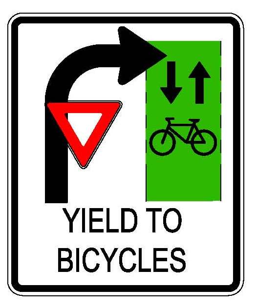
Also, surely due to my complaining on here, the city has finally put up reminder signs like below for right-turning vehicles to yield to cyclists. About time. Hopefully we see these go up on all open bike lanes like Sherbrook and Pembina, etc.
Reply With Quote
     
     
  #142  
Old Posted Jul 11, 2018, 3:17 PM
h0twired's Avatar
h0twired h0twired is offline
Dynamic Positivity!
 
Join Date: Jul 2006
Location: Winnipeg
Posts: 2,914
Quote:
Originally Posted by buzzg View Post
Bannatyne from Main to Adelaide is open now.
Rode down that stretch this morning. The traffic lights are still covered and there was caution tape across the route in a couple of spots.
Reply With Quote
     
     
  #143  
Old Posted Jul 13, 2018, 2:04 PM
buzzg buzzg is offline
Registered User
 
Join Date: Apr 2013
Posts: 7,810
Hey look – we're getting it right!

Reply With Quote
     
     
  #144  
Old Posted Jul 16, 2018, 8:25 PM
buzzg buzzg is offline
Registered User
 
Join Date: Apr 2013
Posts: 7,810
My office looks out right over the bike lane at Main & Bannatyne – I've counted 6 people today riding the wrong way crossing Main. And not "hoodlums" – most of them were in biking gear and/or helmets. Thinking the city might need to put 1-way & do not enter signs up for these lanes.

They're wide enough that it does seem like they could be 2-way. Could see it being confusing as there are places (and will be more) in the city where there's 2-way tracks on 1-way streets. It's not always a given or obvious that a cycle lane follows the same traffic as the street.
Reply With Quote
     
     
  #145  
Old Posted Jul 18, 2018, 12:25 AM
GlassCity's Avatar
GlassCity GlassCity is offline
Rational urbanist
 
Join Date: Aug 2012
Location: Metro Vancouver
Posts: 5,271
Quote:
Originally Posted by buzzg View Post
My office looks out right over the bike lane at Main & Bannatyne – I've counted 6 people today riding the wrong way crossing Main. And not "hoodlums" – most of them were in biking gear and/or helmets. Thinking the city might need to put 1-way & do not enter signs up for these lanes.

They're wide enough that it does seem like they could be 2-way. Could see it being confusing as there are places (and will be more) in the city where there's 2-way tracks on 1-way streets. It's not always a given or obvious that a cycle lane follows the same traffic as the street.
Part of it is just people not caring too. To me it seems like it should be obvious, because you have the bike icon painted on the ground and it should face the right way to you if you're riding!

People go the wrong way on Sherbrook Street too, just because there's nothing really stopping them. I think once more people start cycling overall this will go down, when there will actually be constant traffic and it'd be dangerous to go the wrong way.
Reply With Quote
     
     
  #146  
Old Posted Jul 18, 2018, 12:47 AM
buzzg buzzg is offline
Registered User
 
Join Date: Apr 2013
Posts: 7,810
I think it's pretty ridiculous to expect solely pavement markings to make a completely new concept obvious to the city. Especially if we want people biking in winter. Signage is much more clear (if done right).

I saw someone biking the wrong way down the Pembina lanes today – but there isn't any real signage that makes it clear to cross the street at Warsaw. Are people just supposed to know?

And there's lots of issues with Sherbook where I almost don't blame people. One is that there's only a separated lane on Sherbrook, and not Maryland. Also, Sherbrook is the sole commercial street – it should have been 2-way. There's also issues at intersections... how are bikes supposed to turn left? It's been completely ignored – as have turning interactions at just about every bike lane in the city.
Reply With Quote
     
     
  #147  
Old Posted Jul 18, 2018, 1:05 AM
buzzg buzzg is offline
Registered User
 
Join Date: Apr 2013
Posts: 7,810
On a side note, we've really made some progress on cycling the last couple years, but there's some serious gaps in otherwise great routes.

My #1 priority for next year would be to improve cycling on Wellington Crescent. It already is one of the busiest bike routes in the city, and would be even busier with proper infra. It is billed as a great street for that, but from Grosvenor > east can be treacherous. The street design affords for people to often travel at 60–70 km/h. It's also an amenity enjoyed not just by area residents, but much of the city, as it's the main connector to Assiniboine Park and the Zoo from the north and east.

I think from Lindsay to Guelph the centre gravel path should be widened and paved.

Then it hooks north to a 2-way cycle track using the north lane (current WB curb lane), as it's really not needed. Only one WB lane can go straight across Academy, so it doesn't need the second lane. Allow parking on the EB curb lane, excluding 7–9 am.

There's plenty of room to continue this 2-lane track from Academy to Grosvenor, and can just shift the street a bit if needed, even though it's already fairly wide.

The more "challenging" part would be from Grosvenor to Stradbrook, but I don't think it'd be that tough to at the very least make room for 1-way lanes on either side – whether on the street or raised near the sidewalk (possibly winding at some points around trees).

Stradbrook from Wellington to Osborne is also a challenge, but from Osborne to Donald there is TONS of extra room for a full bike lane. The city definitely needs to make the connection to the RT AT path at Donald more clear to cyclists as well as drivers though. Often drivers are blocking the curb cut as it's such a busy RTOR.
Reply With Quote
     
     
  #148  
Old Posted Jul 18, 2018, 1:09 AM
GlassCity's Avatar
GlassCity GlassCity is offline
Rational urbanist
 
Join Date: Aug 2012
Location: Metro Vancouver
Posts: 5,271
Quote:
Originally Posted by buzzg View Post
I think it's pretty ridiculous to expect solely pavement markings to make a completely new concept obvious to the city. Especially if we want people biking in winter. Signage is much more clear (if done right).

I saw someone biking the wrong way down the Pembina lanes today – but there isn't any real signage that makes it clear to cross the street at Warsaw. Are people just supposed to know?

And there's lots of issues with Sherbook where I almost don't blame people. One is that there's only a separated lane on Sherbrook, and not Maryland. Also, Sherbrook is the sole commercial street – it should have been 2-way. There's also issues at intersections... how are bikes supposed to turn left? It's been completely ignored – as have turning interactions at just about every bike lane in the city.
No for sure we should still put signs up, I'm not abdicating that responsibility. Just feel like people should still be able to figure it out.

And I believe a protected Maryland bikeway is in the budget for the next year or two.
Reply With Quote
     
     
  #149  
Old Posted Jul 18, 2018, 5:11 AM
buzzg buzzg is offline
Registered User
 
Join Date: Apr 2013
Posts: 7,810
^I thought I heard that Maryland from Broadway to the bridge wasn't getting protected lanes as there's no room?

I can't see them taking out a traffic lane, and the curbs are already right agains the trees at many points.
Reply With Quote
     
     
  #150  
Old Posted Jul 18, 2018, 5:26 AM
buzzg buzzg is offline
Registered User
 
Join Date: Apr 2013
Posts: 7,810
Side note, it definitely seems like there's been some changes to the design of McDermot from Rorie to Waterfront. There's MASSIVE bump-outs right at Rorie, and 2 others further down the street. Narrows the street to what seems like only wide enough for a car, not even with a bike lane. Will be interesting to see how it turns out.
Reply With Quote
     
     
  #151  
Old Posted Jul 18, 2018, 3:14 PM
windypeg windypeg is offline
Registered User
 
Join Date: Jul 2013
Posts: 417
Quote:
Originally Posted by buzzg View Post
I think it's pretty ridiculous to expect solely pavement markings to make a completely new concept obvious to the city. Especially if we want people biking in winter. Signage is much more clear (if done right).

I saw someone biking the wrong way down the Pembina lanes today – but there isn't any real signage that makes it clear to cross the street at Warsaw. Are people just supposed to know?

And there's lots of issues with Sherbook where I almost don't blame people. One is that there's only a separated lane on Sherbrook, and not Maryland. Also, Sherbrook is the sole commercial street – it should have been 2-way. There's also issues at intersections... how are bikes supposed to turn left? It's been completely ignored – as have turning interactions at just about every bike lane in the city.
There's a million places where cycling infrastructure could be vastly improved at an extremely low cost with just some better signage and wayfinding. One of my biggest peeves is at the western end of the Assiniboine bike lane where it crosses the sidewalk by the Leg. There's no paint, signs or anything. So a lot of cyclists don't know where to go and either bike down the sidewalk or the wrong way down Assiniboine which is only one lane there. And pedestrians gather and loiter right where the paths intersect - fair enough, it's in the middle of some nice green space - but they don't realize there are bikes coming through there.

Quote:
Originally Posted by buzzg View Post
On a side note, we've really made some progress on cycling the last couple years, but there's some serious gaps in otherwise great routes.

My #1 priority for next year would be to improve cycling on Wellington Crescent. It already is one of the busiest bike routes in the city, and would be even busier with proper infra. It is billed as a great street for that, but from Grosvenor > east can be treacherous. The street design affords for people to often travel at 60–70 km/h. It's also an amenity enjoyed not just by area residents, but much of the city, as it's the main connector to Assiniboine Park and the Zoo from the north and east.
Wellington from River ave to Academy is infuriating. It's supposed to be a bike route. The lanes are super wide and there is enough space on the boulevards on either side to add a whole lane of traffic, nevermind a bike lane. There should be full protected lanes on both sides but instead there's not even paint so everyone just drives like Elaine Benes in those super wide lanes. It's stupid.
Reply With Quote
     
     
  #152  
Old Posted Jul 18, 2018, 5:22 PM
headhorse headhorse is offline
BANNED
 
Join Date: Mar 2011
Location: Winnipeg
Posts: 1,743
^ Winnipeg also has a huge issue with not painting busy streets? balmoral st south of broadway is a great example where it's wide enough for four lanes of traffic but there's no lines or visual barriers to slow anyone down so everyone drives 60 km/h through a high pedestrian and cyclist area. just paint the street lines, seriously.

tons of these streets also have room for separated bike lanes (balmoral, westminster, nassau, roslyn, etc). none of them have lines painted on them.
Reply With Quote
     
     
  #153  
Old Posted Jul 18, 2018, 9:21 PM
buzzg buzzg is offline
Registered User
 
Join Date: Apr 2013
Posts: 7,810
Quote:
Originally Posted by headhorse View Post
^ Winnipeg also has a huge issue with not painting busy streets? balmoral st south of broadway is a great example where it's wide enough for four lanes of traffic but there's no lines or visual barriers to slow anyone down so everyone drives 60 km/h through a high pedestrian and cyclist area. just paint the street lines, seriously.

tons of these streets also have room for separated bike lanes (balmoral, westminster, nassau, roslyn, etc). none of them have lines painted on them.
I would argue the contrary and say we paint way more streets than most other Canadian cities. Tons of streets in Toronto – including many segments of Bloor – have only a yellow centre line, and don't divide same-way traffic. I think in many places where there's parking, having a line makes drivers in the centre lane think they can blow by because it's "their lane" and cyclists or others have to share the right-hand lane. Leaving it open leaves it a little more up in the air, as a shared space, and people use more caution.
Reply With Quote
     
     
  #154  
Old Posted Jul 19, 2018, 1:36 AM
GlassCity's Avatar
GlassCity GlassCity is offline
Rational urbanist
 
Join Date: Aug 2012
Location: Metro Vancouver
Posts: 5,271
Quote:
Originally Posted by buzzg View Post
^I thought I heard that Maryland from Broadway to the bridge wasn't getting protected lanes as there's no room?

I can't see them taking out a traffic lane, and the curbs are already right agains the trees at many points.
I haven't heard anything from anyone, so all I know is what I saw from the 2018 budget. It's possible that I'm misinterpreting, but it says "Maryland Ave/Sherbrook Ave Upgrade to Protected Bike Lane" on page 46 of the PDF, at a cost of $250,000 in 2019.

https://winnipeg.ca/finance/files/20...et_Volume3.pdf
Reply With Quote
     
     
  #155  
Old Posted Jul 19, 2018, 4:57 PM
Authentic_City's Avatar
Authentic_City Authentic_City is offline
Registered User
 
Join Date: Apr 2011
Posts: 1,643
I rode the McDermot Ave protected bike lane this AM from Tecumseh St. (at HSC) to Sherbrook St. It's not officially open yet, but the barricades were moved aside enough to allow a single bike through. Very nice design! Crews are still working on the section from Sherbrook eastward, but it will be very nice when completed. I'm really looking forward to it.
Reply With Quote
     
     
  #156  
Old Posted Jul 20, 2018, 3:21 AM
buzzg buzzg is offline
Registered User
 
Join Date: Apr 2013
Posts: 7,810
Quote:
Originally Posted by GlassCity View Post
I haven't heard anything from anyone, so all I know is what I saw from the 2018 budget. It's possible that I'm misinterpreting, but it says "Maryland Ave/Sherbrook Ave Upgrade to Protected Bike Lane" on page 46 of the PDF, at a cost of $250,000 in 2019.

https://winnipeg.ca/finance/files/20...et_Volume3.pdf
I would love to be wrong, but I think it's just from Portage to Nortre Dame/HSC.
Reply With Quote
     
     
  #157  
Old Posted Jul 20, 2018, 8:04 PM
GlassCity's Avatar
GlassCity GlassCity is offline
Rational urbanist
 
Join Date: Aug 2012
Location: Metro Vancouver
Posts: 5,271
Quote:
Originally Posted by buzzg View Post
I would love to be wrong, but I think it's just from Portage to Nortre Dame/HSC.
That would make sense, didn't even think of that. For some reason I just automatically assumed it would be from the river to Portage.
Reply With Quote
     
     
  #158  
Old Posted Aug 18, 2018, 5:03 PM
buzzg buzzg is offline
Registered User
 
Join Date: Apr 2013
Posts: 7,810
Some observations on new Exchange bike lanes:

- Don't understand why the bus has to stop in the bike lane on McDermot right before Main, when all other stops have the islands. The busses there are pretty much always stopped/loading at a red light, and in rush hour there's lots of pedestrians crossing, so having the bus stop in the right turn lane would not be much of an issue.

- There needs to be proper signage for vehicles now that Main/McDermot has been reconfigured. Not clear at all aside from road painting who goes where.

- The design of McDermot from Rorie > Waterfront changed from the released plans. They put in angled parking like on Bannatyne, but the road is much narrower, barely wide enough for even cars to get by. There's also not really a place to get to the AT path along Waterfront – the curb cut goes to the sidewalk, which is technically not the AT path. I don't understand why the path doesn't continue between Lombard & Bannatyne.

- the city has removed all the signs that had a car on one side and bike on the other with arrows pointing to respective lanes, and replaced them with standard "go around this median" arrows, except cyclists. The signs are huge. It's definitely a bit better as the originals were hard to read, but now there's only signage for motorists. We need to use green diamond lane signage like they do in Minneapolis or Sask. It's more clear for everyone. Also time to overhaul "bike route" sign system.
Reply With Quote
     
     
  #159  
Old Posted Aug 19, 2018, 1:11 AM
ywgwalk ywgwalk is offline
Formerly rypinion
 
Join Date: Mar 2018
Location: Exchange District, Winnipeg
Posts: 389
Quote:
Originally Posted by buzzg View Post
Some observations on new Exchange bike lanes:

- Don't understand why the bus has to stop in the bike lane on McDermot right before Main, when all other stops have the islands. The busses there are pretty much always stopped/loading at a red light, and in rush hour there's lots of pedestrians crossing, so having the bus stop in the right turn lane would not be much of an issue.
The problem is you need both the lane where the bus will stop AND the pavement that the passengers will load to/from (both separate from the bike lane). There is no existing right side parking lane to put the bus island into. They'd have to switch the parking from left side of the street to right, or take enough parking out from the left side and have the lanes curve into it after Albert.

Last edited by ywgwalk; Aug 19, 2018 at 1:29 AM.
Reply With Quote
     
     
  #160  
Old Posted Sep 4, 2018, 3:34 AM
buzzg buzzg is offline
Registered User
 
Join Date: Apr 2013
Posts: 7,810
It's interesting that the Princess Street protected lane project is being done in full this year – on the city's website it says they were going to present options Fall 2018 with construction next year. Happy they're doing it now, but wonder what caused/allowed them to do it this year, especially with no public presentations.

I'm glad it's happening now – the Exchange construction has been hell this summer (well worth it) and I would not want to see it happen again next year. It's going to be a whole new place next summer.
Reply With Quote
     
     
This discussion thread continues

Use the page links to the lower-right to go to the next page for additional posts
 
 
Reply

Go Back   SkyscraperPage Forum > Regional Sections > Canada > Manitoba & Saskatchewan
Forum Jump


Thread Tools
Display Modes

Forum Jump


All times are GMT. The time now is 9:23 PM.

     
SkyscraperPage.com - Archive - Privacy Statement - Top

Powered by vBulletin® Version 3.8.7
Copyright ©2000 - 2024, vBulletin Solutions, Inc.