How handy to suggest the train stops in the middle of the intersection at 4th and Red River, blocking that intersection. The front of the train will actually be near 4th and Trinity, two blocks closer to Congress.

That's a difference of 670 feet. A one car train is only 134 feet long. A two car train is less than half the 670 feet you suggest.
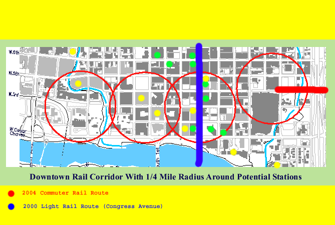
From the front of the train, at 4th and Trinity, a quarter mile north reaches 8th Street, a quarter mile east reaches I 35 west service road, a quarter mile south reaches the cul de sac at the of Trinity, and a quarter mile west reaches Congress.
If CapMetro placed stations where I suggested, you'll only have to walk one-eight mile along 4th Street. Reaching from the Colorado River to 8th street.
p.s. Most blocks in downtown Austin are 350 feet squares, from centerline of street to centerline of street.
One quarter mile = 1320 feet = 3.77 blocks; closer to 4 blocks vs 3 blocks.
Interesting walking distance to train station statistics:
http://www.fairfaxcounty.gov/plannin..._abstracts.pdf
I believe BART guidelines break the distances into percentages best:
In the San Francisco Bay Area Rapid Transit System (BART), 80% of the pedestrians using BART during peak hour periods walked less than 10 minutes to the station, while somewhat over half of those pedestrians walking under 6 minutes to reach their destination. The distance for a 6 minute walk was estimated to be a quarter of a mile.
30% of trips walked to BART station
Of that 30% who walked, 80% walked less than 10 minutes (45% walked under 6 minutes (approximately 1350 feet) and 35% walked between 6-10 minutes, approximately 1350 to 2250 feet)
Distance for a 6 minute walk was estimated to be about ¼ mile
Overall average walking time for all who walked to the BART stations was 8.8 minutes
Generally considered that the average person walks about 225 feet per minute
Overall average length of walk was probably about 1,980 feet (.375 miles)
Average walking time for walkers to their destination at end of trip was 7.2 minutes or about 1,600 feet (1/3 mile)
The average of all walkers was a third of a mile, up to 1600 feet. That would be 4.5 blocks in downtown Austin.
And that's the
average of those walking to the train station, including those walking shorter and
longer distances.
The quarter mile rule means 80% would walk that far without a second thought. But the average (50%) passenger that walks to a train station walks a third of a mile. You'll find some willing to walk further, and the statistics vary by city and terrain.
In Calgary and Edmonton, where it snows a lot and gets freezing cold most winters:
For the Canadian cities, the average walking distance to suburban stations is (649m=2129 feet=0.4 miles) with a 75th-percentile distance of (840 m=0.52 miles). And in Edmonton, 1750m (1.08 miles) was maximum that people would walk to train station.
Chart to illustrate people’s tolerance for walking:
In a highly attractive, completely weather-protected and artificially climatized environment
20 Minutes 5,000 Feet (almost a mile) (In a Mall)
In a highly attractive environment in which sidewalks are protected from sunshine and rain
10 Minutes 2,500 Feet (almost a half mile) (Parks and Zoos with nice sidewalks)
In an attractive but not weather-protected area during periods of inclement weather
5 Minutes 1,250 Feet (almost a quarter mile) (Does it rain that much in Austin? Downtown streets with sidewalks)
In an unattractive environment (parking lot, garage, traffic-congested streets without sidewalks)
2 Minutes 600 Feet (almost one-eight a mile) (Dark areas are never popular)
There will be some healthy passengers who will make the 0.8 mile walk to the State Capital from the Convention Center Station.


 Prev
Prev


 Linear Mode
