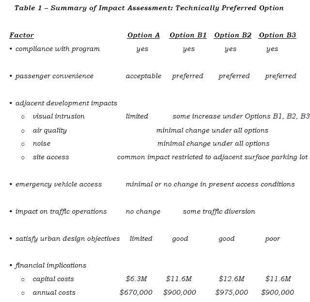
In the next city's budget council have set the Downtown terminal as receiving the highest priority for funding with construction starting in 2008. So far council hasn't decided which option to select from, odds are Option A will likely be selected.
Option A – MacNab/Hunter Terminal
Option B1 – MacNab Terminal
Option B2 – MacNab Terminal
Option B3 – MacNab Terminal
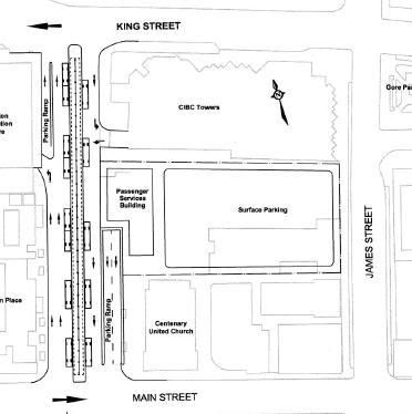
Option A – MacNab/Hunter Terminal
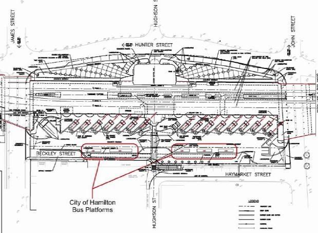
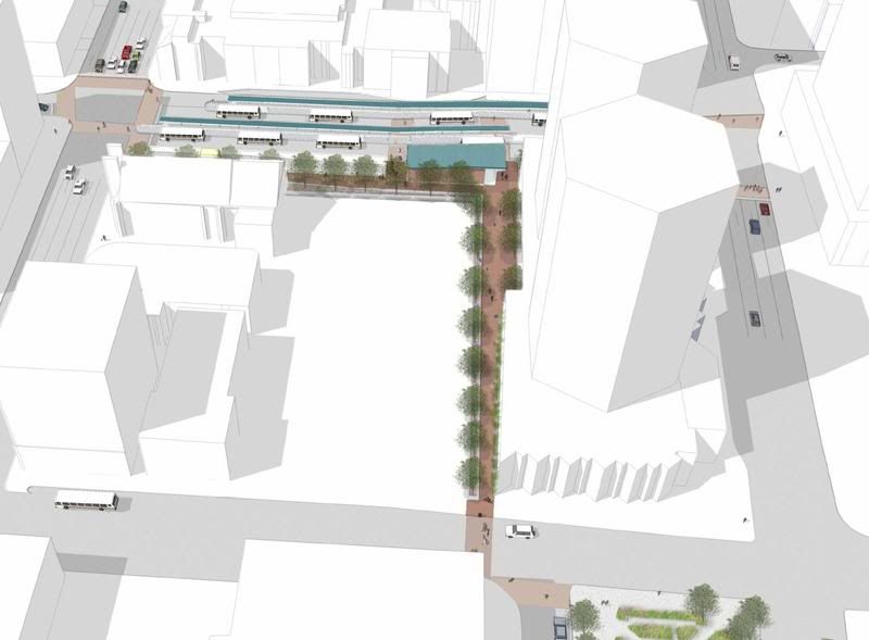
This option represents a concept which could meet the adopted program requirements while minimizing the amount of private property acquisition. A total of 10 platform locations would be provided at the MacNab Street location using the present island platform layout. The access to the surface parking lot from MacNab would be closed to allow construction of a new passenger terminal building and operations centre on a portion of the parking lot site. No changes in the present traffic patterns would be introduced.
To meet the required 13-platform program, three platforms would be developed along Hunter Street adjacent to the GO TH&B Terminal. The bus platforms would be created in the area presently occupied by the present curb parking. An estimated total of eight parking spaces would be displaced.
The functional layout is illustrated in Figure 1. The allocation of the platform positions reflects the following bus routing arrangement.
• Routes 23, 24, 25, 26, 27 and 35 would operate north on John, west on King, south on MacNab, east on Main and south on James Street.
• Route 5A/34 would be interlined and be routed west on Hunter, north on MacNab and west on King;
• Route 10 westbound would be routed west on king, south on MacNab, east on Main, north on James and west on King. Route 10 eastbound would be routed east on Main, north on James, west on King, south on MacNab and east on Main;
• Route 51 – University would be routed east on Main, north on MacNab and return west via King Street;
• Route 6, 7 and 8 would be rationalized. From York, the interlined route would
operate south on James, west on King, south on MacNab, east on Main and south on James. From John, the route would operate west on Hunter, north on MacNab, west on King and north on Bay;
• Platforms for Route 2, 3 and 4 would be developed along Hunter Street adjacent to the GO Transit terminal. These routes would operate south on John, west on Hunter and north on James Street. By inspection, it would appear that this routing would have a marginal effect on the route running time and not trigger a requirement for additional vehicles.
Option B – Extended MacNab Street
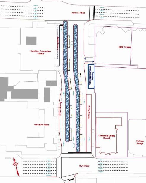
Under these options, the full terminal program requirements would be accommodated at an expanded MacNab Street location. Access to the Convention Centre would be retained but completely separated from the flow of HSR vehicles. Similarly, access to the CIBC underground parking facility would be provided to and from King Street. Three alternative facility layouts were developed under this general concept, each exhibiting comparable property impacts and construction costs.
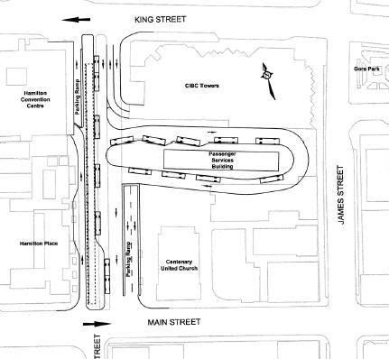
Option B1 - MacNab Terminal
The property presently being used for surface parking would be transformed to a large island platform providing nine positions for HSR vehicles. The passenger terminal building would be situated within the footprint of the island platform. The remainder of the required platforms would be provided within the revamped MacNab Street road allowance.
The allocation of the 14 platform positions assumes the following routing:
• All Mountain routes (Routes 23, 24, 25, 26, 27 and 35) would operate north on John, west on King, south on MacNab into the new off-street terminal, then exit the terminal, proceed south on MacNab Street to Main, then east on Main to turn south on James Street;
• Routes 2, 3 and 4 would use the platforms within the MacNab road allowance by proceeding south on James Street, west on King Street and then south on MacNab into the terminal area. The routes would then exit the terminal and proceed to Main Street and then north on John Street;
• Route 6, 7 and 8 would be rationalized to eliminate Route 7. The interlined route would operate south on James, west on King, south on MacNab, east on Main and south on James. Northbound, the route would operate north on John, west on King, south on MacNab, east on Main and north on James to King;
• Route 5A/34 would be interlined and routed north on James, west on King, south on MacNab and east on Main;
• Route 51 – University would be routed east on Main, north on MacNab and return west via King Street.
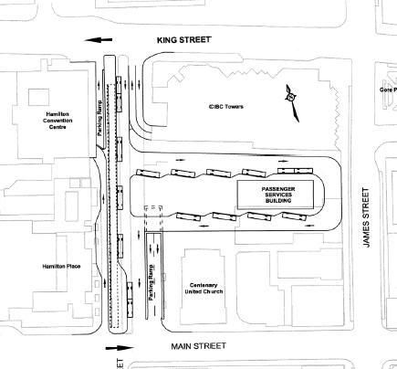
 Option B2 - MacNab Terminal
A minor variation on Option B1, this alternative would introduce a large island
platform into the existing parking lot property immediately east of MacNab Street. However, in order to create a more rectangular island configuration and reduce the required turning radius for buses to re-enter MacNab Street, a portion of the present ramp from the underground parking to Main Street would be enclosed. This would also require re-aligning the vertical profile of the ramp and covering approximately 13m of the existing opening. A review of the geometric and structural feasibility of this adjustment was undertaken to estimate the possible capital cost implications. The bus routing and platform position allocation would be the same as Option B1.
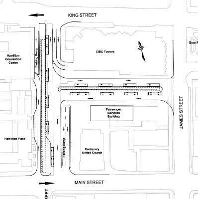
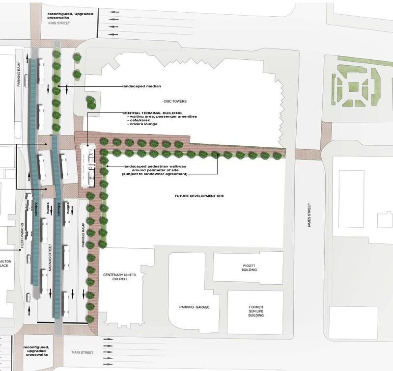
 Option B3 - MacNab Terminal
This alternative would provide 13 bus bays and enhances the overall flexibility of transit operations by allowing access to the terminal from both MacNab and James Streets. Operationally, buses would use MacNab Street as they do now and additional passenger islands would be provided on the surface parking lot adjacent to MacNab Street. Additional bays could be developed to distribute among those routes sharing platforms or as bus layover positions. If these additional bays were developed, the southern side of the platform would require two-way bus operations to share a single lane, thereby allowing buses to stop on both sides of the lane. While this reduces the
required width of the facility as a whole, the arrangement may introduce operational concerns. The bus routings would remain consistent with those identified under Option B1.
Based on the report it narrowed it down to Option A or B1 for councillors. Problem with B1 is that Yale Properties owns the parking lot and is asking for too much money - $2.7 million.


 Prev
Prev


 Hybrid Mode