My apologies to
Tourmaline for not remembering his earlier post on Phil's Diner.
& thanks for the clarification on the Luther Kennett photograph
Noir Noir and
oldstuff.
Quote:
|
Originally Posted by oldstuff
Another sad story is that John, brother of Luther and the others, died at the Walla Walla, (Washington) County Farm ( prison/poor farm) in 1932.
You wonder if he had the same problem as his brother. That facility also had a tubercular ward.
|
That's a good question
oldstuff. It's sad that two of the brothers met the same fate (dying in state facilities)
________________
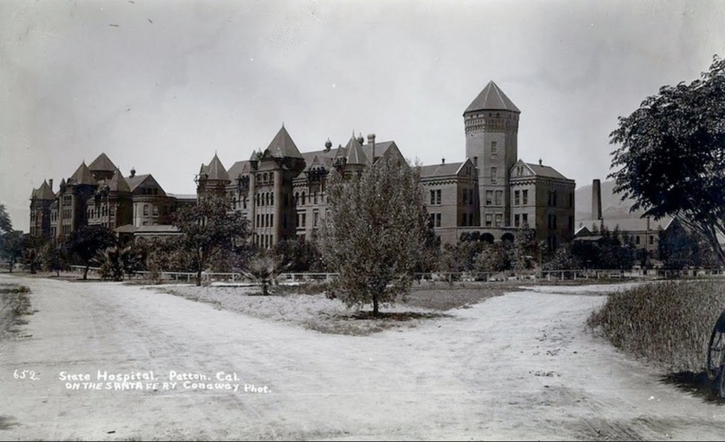
This is Patton State Hospital where Luther '
Chutes Photographer' Kennett was sent for his epilepsy.
[full name: Patton State Forensic Mental Hospital for the Criminally Insane]
 SBDEPOTMUSEUM
It couldn't look more forboding if they tried.
I'll include this second view as well.
 CITY OF SAN BERNARDINO
I can't square this image with the top photograph. Is it...flipped....? Or am I just looking at it wrong?
 A BIT OF HISTORY
"The hospital opened up in 1893 as the Highland Insane Asylum in the city of Highland, just outside of San Bernardino, California.
A BIT OF HISTORY
"The hospital opened up in 1893 as the Highland Insane Asylum in the city of Highland, just outside of San Bernardino, California.
It was renamed Patton after one of its board members in 1927, and its current address lists the city as Patton, CA.
But Patton isn't a city exactly: it's just the hospital. It's that big." AVOIDING REGRET
By the way, did you notice the roundish structure in the top two photos? (on the left in the top pic / on the right in the 2nd pic)
Could this be it?
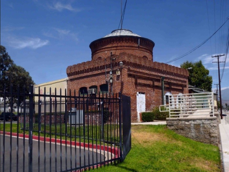 AVOIDING REGRET
"The last remaining structure of the original brick insane asylum."
UPDATE:
This
is part of the old asylum but it isn't the structure I thought it might be. (for one thing...it's way too small)
"This is an old train depot that sat near the front entrance of the grounds. A relic from the narrow gauge railroad
that used to bring goods and supplies from the outside." from AVOIDING REGRET
But Sandi Hemmerlein at '
Avoiding Regret' doesn't say
where this little piece of history is located.
From her description I'd say it's on the edge/outskirts of the present day hospital. But so far I haven't been able to spot it.
Anyone want to play 'Where's Waldo' with me and help find the little booger. (the old depot)
use this link--->
GOOGLE EARTH
__


 Prev
Prev


 Linear Mode
