The map is centered on the tallest building marked for the city, Hoffman-Roche Research Tower. Zoom-in to the map (double-click) and pan-around (click + drag) to see all buildings. Click on a building's marker to open the information page for that building. Only highrise buildings are marked on the map. See below for more information.
Total buildings marked -
Total buildings visible -
Loading map...
Please complete the Human Verification to display the map.
You can link to a map that you have altered with the map controls, simply use the Map URL found below the map. When this special URL is used to load a map, all of the previous changes to the map, such as map position, zoom level and building selection, will be retained.
Map Boundaries
The map on this page shows only buildings in the city/administrative region of Nutley. It does not include buildings in neighboring cities or municipalities, or elsewhere in the metropolitan region Nutley is situated in (if one exists).
To clarify this situation take for example Los Angeles. The Los Angeles metropolitan region is comprised of many individual cities, but the map for the city of Los Angeles does not include buildings in Beverley Hills because Beverley Hills is a separate city.
For cities within a larger metropolitian area, look for red markers on the map to link to the surrounding metropolitian area cities, where additional buidings are marked. Currently it's not possible to view buildings from all of the cities in a metropolitan region together on one map.
Definition of "Highrise"
Only highrise buildings are marked on the map. For the purposes of this website, a highrise is considered to be a building of at least 12 storeys or a multi-floored building at least 35 meters tall. For the sake of convenience highrise buildings are also referred to as skyscrapers (we don't set a minimum height for a skyscraper other than it must be a highrise building).
If you want the map to display only buildings above a certain height, use the Minimum Height Selection control to the left of the map.
Construction Status Definitions
•
Built - Structure currently exists. Construction is complete and structure has potential for use. Structures undergoing renovation remain in this category.
•
Under-Construction - Structure is currently under-construction. Structural components are being assembled permanently on-site. Excavation doesn't count as construction.
•
Proposed - Structure is planned to be built and construction hasn't yet begun. Includes both structures which have been approved by local authorities and those which have not (we don't have a distinct 'approved' category).
•
On-Hold - Construction had begun at one point but has now stopped. This is a sub-category of Under-construction.
Frequently Asked Questions
Some buildings on the satellite maps aren't marked. Why is this?
This could be for a number of reasons:
•
The building may not yet exist in our database. Typically, every city has it's tallest highise buildings included in the database and appearing on the map, but the multitude of shorter highrise buildings may not.
•
The building may be outside of the city boundary. For cities within a larger metropolitian area, look for red markers on the map to link to the surrounding metropolitian area cities, where additional buidings are marked.
•
Only highrise buildings are marked (a highrise is a multi-floored building of at least 35 meters in height or at least 12 floors). Some multi-floored buildings which are visible on the satellite photos but aren't marked may not be considered as a highrise. For example, a 10 storey residential building (with a height of below 35 meters) is not considered a highrise and will not be marked on the map. In the image to the right, the lower building, while casting a large shadow, is not marked as a highrise because it has only 10 floors, while the building across the street from it, which has 13 floors, is marked. Also, structures such as Toronto's CN Tower or Seattle's Space Needle, while certainly being quite tall, aren't marked because they aren't considered as highrises. The maps may be expanded in the future to include additional types of structures.
Some buildings appear to be marked in the wrong location on the satellite maps. Why is this?
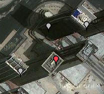
Highrise buildings on the map are marked at their base position where they rise from the ground. Sometimes satellite imagery of a city shows buildings from an oblique (angled) view and a building may appear to rise offset from its actual map location.
In the image to the right, the red marker is marking the tower which rises to the right of it, not the tower with the roof the marker is over top of. This issue is caused by the oblique view of the satellite imagery. Why are there ads on this page?
Because of the large amount of visitor use of the map pages, the high quality Google Maps cost hundreds of dollars a month to use here. Having ads on these pages helps to pay for this.

 Skyscraper Diagram
 Timeline Diagram
 City Page
 Discussion Forum
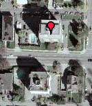
 Highrise buildings on the map are marked at their base position where they rise from the ground. Sometimes satellite imagery of a city shows buildings from an oblique (angled) view and a building may appear to rise offset from its actual map location.