

M II A II R II K
Active member
High Volume Intersection Study
High Volume Intersection Study: http://www.compassidaho.org/documen...ol1_Implementation_Guidelines_Final_May30.pdf
Operational Effects of Signalized Superstreets: http://repository.lib.ncsu.edu/ir/bitstream/1840.16/6112/1/etd.pdf
http://ti.org/antiplanner/?p=4365
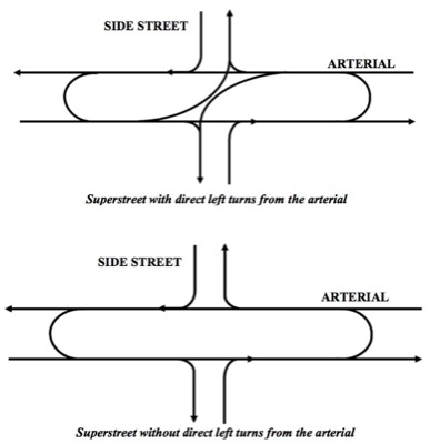
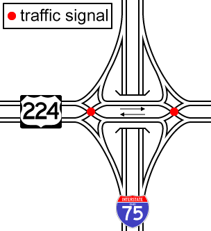
High Volume Intersection Study: http://www.compassidaho.org/documen...ol1_Implementation_Guidelines_Final_May30.pdf
Operational Effects of Signalized Superstreets: http://repository.lib.ncsu.edu/ir/bitstream/1840.16/6112/1/etd.pdf
Introduction
The Community Planning Association of Southwest Idaho (COMPASS) adopted Communities in Motion: Regional Long-Range Transportation Plan 2030 (CIM) in August 2006. COMPASS, as a part of its metropolitan planning organization (MPO) responsibilities, developed the plan for the region with the assistance of its member agencies. The High Volume Intersection Study (HVIS) was initiated in response to findings and policy statements that appear in CIM.
A key objective of the HVIS is to develop guidelines and recommendations for implementing innovative intersection designs in the region. The project team prepared this report as a means of helping COMPASS achieve that objective.
The recommendations in this report are suitable for use by highway agencies, cities, counties, and by other agencies/jurisdictions throughout the COMPASS region. This report’s recommendations will help land use agencies establish standards for innovative intersection types, which will facilitate implementation of innovative intersections throughout the COMPASS region. Information from the report may also be useful for updating the regional travel demand models.
1.1. What is an “Innovative Intersection”?
For this document, a conventional high-capacity intersection typically would have a dedicated pocket for right turns, 2-3 through lanes per direction, and double left-turn pockets with left-turn arrows. This results in a 4-phase signal (a left phase and a through phase for the two directions of one street, and the same on the cross street). An innovative intersection is generally defined as any at-grade design concept that is able to reduce the number of phases at the main intersection, thereby increasing the efficiency and capacity of the signal. In most cases this is accomplished by rerouting left turns at a point well ahead of the main intersection, or to require the driver to do something unusual, such as first go through, then make a U-turn, and finally a right turn.
Why are innovative intersections uncommon?
• Lack of industry awareness – many are
relatively new ideas.
• Though the cost/benefit ratio is often very
good, they still typically cost more than a
conventional intersection.
• In some cases they are out of context or
don’t work in a particular location.
• Usually requires turning movements that
differ from typical driver expectations.
• Problems at conventional intersections have
historically been tolerable in spite of their
inefficiency.
http://ti.org/antiplanner/?p=4365

