HomeDiagramsDatabaseMapsForum About
     

Go Back   SkyscraperPage Forum > Photography Forums > Found City Photos

Reply

 
Thread Tools Display Modes
     
     
  #15561  
Old Posted Jul 13, 2013, 6:54 AM
sadykadie2 sadykadie2 is offline
Registered User
 
Join Date: Jun 2013
Posts: 148
That picture of the car crash taken where the sign says "Garden Grove" has a sign "Orange County Fair and Recreation Grounds". That's still here in Costa Mesa.
Reply With Quote
     
     
  #15562  
Old Posted Jul 13, 2013, 7:44 AM
Lorendoc Lorendoc is offline
Registered User
 
Join Date: May 2013
Location: Los Angeles, California
Posts: 428
Wulff's Peak

Quote:
Originally Posted by ethereal_reality View Post
Lorendoc, I also had this in a file but hadn't posted it yet.


Is that a bow knot in the center?
__
Thank you 
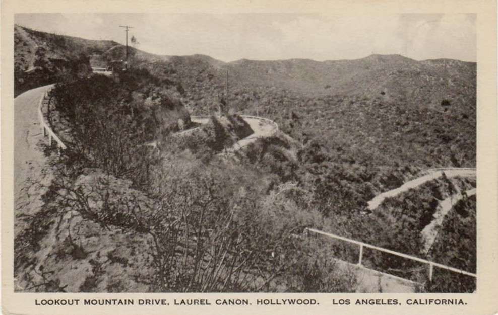
e_r for the reverse angle picture of "Double Bow Knot Boulevard. It looks northwest towards the high north-south ridge that separates Coldwater Canyon in the west from the Wonderland bowl and Laurel Canyon to the east. This ridge, a kilometer long, is anchored on each end by a prominence having the same elevation of about 1550 feet. It is the highest land between Laurel Canyon on the east, Mulholland Drive on the north, Coldwater Canyon on the west, and Sunset Boulevard on the south.

The northern promontory is today occupied by the 300' tall KCRW-KYSR Broadcast tower at 2555 Briercrest. (For more about this tower, see http://www.earthsignals.com/Collins/0017/). The southern promontory I believe is Wulff's Peak, as the contemporary real estate ads and newspaper would seem to suggest.

Here is the 1924 topo map with the north and south prominences of the high ridge marked on the map:


The two lines of evidence that this southern knob is Wulff's Peak are 1) the newspaper articles all describe the ascent of Wulff's Peak as starting from Laurel Canyon via the Double Bow Knot Road and Upper Crescent Drive, ultimately to an altitude of 1500+ feet and 2) the northern knob with the later transmitter could only have been accessed from Coldwater Canyon at the time the topo map was made. BUT: confusingly, the FCC description of radio towers at Wulff's Peak state their location as "Lookout Mountain," which is almost certainly wrong.

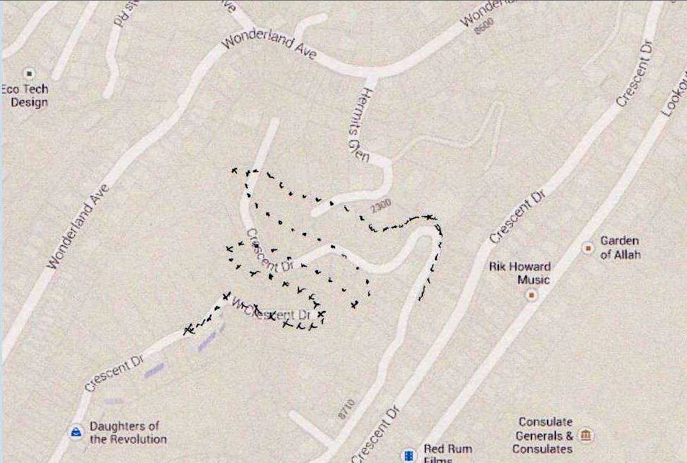
Back at Double Bow Knot Boulevard, I made an overlay of the 1924 topo on top of the current street map from Google, to indicate on the latter the relationship of DBKB with the current street pattern:


DBKB is indicated by black dots. The grades, at least the upper ones, are still there after 100 years of erosion and regrading. And it is very clear that upper and lower Crescent Drives did connect.

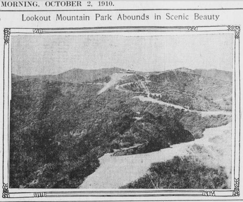
While I am reasonably satisfied about the location of Wulff's Peak, I am not so sure about where Wonderland Point and Lookout Mountain and the Lookout Mountain Inn were.

e_r's photo showing Wulff's Peak and the "proposed" scenic railroad that he said were from a 1895 newspaper advert actually was from the Los Angeles Herald on May 30, 1909. I am going to the LAPL Central branch tomorrow and I will see if I can get a better reproduction; the photo purports to show Wonderland Point and other controversial locations. One thing it would *not* show is the Lookout Mountain Inn, because that was not built until 1912. More to follow - and again I want to express my admiration for the expertise and commitment to accuracy that posters to this thread show every day.
Reply With Quote
     
     
  #15563  
Old Posted Jul 13, 2013, 12:03 PM
CityBoyDoug CityBoyDoug is offline
BANNED
 
Join Date: Apr 2013
Posts: 2,868
Old cameras, new cameras ...all a delight.

Quote:
Originally Posted by Sonny☼LA View Post
Man, it's crazy posting on here - looked like so much fun, I had to jump in. Hope I don't embarrass myself with a repost or some such silliness. I'm gonna try quoting, linking, and sourcing all for the first time, here. If this all works, I'm high-fiving myself.
Hi Justin [Sonny]: Your photos are most noir and compelling. Welcome to this thread.

Douglas
Reply With Quote
     
     
  #15564  
Old Posted Jul 13, 2013, 5:20 PM
Chuckaluck Chuckaluck is offline
Registered User
 
Join Date: Apr 2012
Posts: 649
Quote:
Originally Posted by GaylordWilshire View Post

When did bolting/bracing of brickwork become commonplace? The masonry below is from '45, yet I assumed this was mostly an advent following the '71 Sylmar Quake. Possibly a function of the '33 Code, or a forward thinking building owner?

1945 - Rodeo Auto Park, BH. Shirley Temple and mother Gertrude on way to shop for wedding dress.
Reply With Quote
     
     
  #15565  
Old Posted Jul 13, 2013, 5:39 PM
Moxie's Avatar
Moxie Moxie is offline
Registered User
 
Join Date: Apr 2012
Location: Illinois
Posts: 103
Quote:
Originally Posted by Sonny☼LA View Post
Man, it's crazy posting on here - looked like so much fun, I had to jump in. Hope I don't embarrass myself with a repost or some such silliness. I'm gonna try quoting, linking, and sourcing all for the first time, here. If this all works, I'm high-fiving myself.
Nice job with your first post! Does high-fiving yourself = clapping?

I love the sun icon in your name...how'd you manage that?
Reply With Quote
     
     
  #15566  
Old Posted Jul 13, 2013, 6:22 PM
Chuckaluck Chuckaluck is offline
Registered User
 
Join Date: Apr 2012
Posts: 649
1941 - Jimmy Stewart standing at Westwood train depot. (Service induction publicity photos)
http://dlproj.library.ucla.edu/deriv...0178771a_j.jpg

1941 - Stewart riding the red car to induction office.
http://dlproj.library.ucla.edu/deriv...0178620a_j.jpg

Any other photos of the train depot/station? "Westwood Blvd." To be distinguished from the station at Exposition and Sepulveda Boulevards.
http://farm6.staticflickr.com/5303/5...97652fab_o.jpg
Reply With Quote
     
     
  #15567  
Old Posted Jul 13, 2013, 8:39 PM
ethereal_reality's Avatar
ethereal_reality ethereal_reality is offline
Registered User
 
Join Date: Feb 2008
Location: Lafayette/West Lafayette IN, Purdue U.
Posts: 16,347
Quote:
Originally Posted by Sonny☼LA View Post
My first try with infrared. The subject: the lovely Mauretania. Shot on a plastic toy Diana camera with a 720nm (nearly opaque) filter taped to the front. Five second exposure in bright daylight.


Source: My Flickr

-----------------------------------------------------------------------

And finally, an awesome Schindler find down on Compton & 49th that I don't think has been mentioned on Noirish yet - the Bethlehem Baptist Church, commissioned by an African American congregation in 1944, now vacant for more than a decade. The LA Times recently did a piece about a photographer re-discovering the building, about the same time I heard about it and had to drive down and see it: Found: R.M. Schindler's hidden church

Sorry for the grainy, blurry shots but that's how I like 'em. Most of my photos are taken while trying out an old camera for the first time. Many are from the noir era and might've been used on the streets, which adds to the appeal for me. I'm not quite deep in it enough to go around with a Graflex but I won't rule it out in the future.

This black & white shot was taken with a Ditto 99 from 1952 (Finetta 99 in Germany), with a slightly sticky shutter return and a powerful (and loud) spring motor drive. Film is East German ORWO ("Original Wolfen") NP55 expired in 1992.


My Flickr


My Flickr


Source: LA Times
Enjoyed your before and after Sonny_LA, but I was especially amazed by your original photographs using vintage cameras and film.
Yes, actual film people! You've turned ordinary photos into works of arts.

I've heard about the Schindler church but somehow never got around to finding it (I never would have guessed Compton). It looks as if it's getting to the point where it's beyond repair (can you imagine the shape it would be in if it had been built in a place with inclement weather?) The church resembles a jigsaw puzzle, which made me think it could possibly be dismantled and moved to a more viable neighborhood
(or to a park, as a community center perhaps....maybe even a park in Compton)

-anyway, your post was great.
__

Last edited by ethereal_reality; Jul 13, 2013 at 11:15 PM.
Reply With Quote
     
     
  #15568  
Old Posted Jul 13, 2013, 9:32 PM
ethereal_reality's Avatar
ethereal_reality ethereal_reality is offline
Registered User
 
Join Date: Feb 2008
Location: Lafayette/West Lafayette IN, Purdue U.
Posts: 16,347

http://chroniclingamerica.loc.gov/

I wonder why they didn't go with "KON-KRE-KOTA"?
__
Reply With Quote
     
     
  #15569  
Old Posted Jul 13, 2013, 10:44 PM
ethereal_reality's Avatar
ethereal_reality ethereal_reality is offline
Registered User
 
Join Date: Feb 2008
Location: Lafayette/West Lafayette IN, Purdue U.
Posts: 16,347
Quote:
Originally Posted by Lorendoc View Post
e_r's photo showing Wulff's Peak and the "proposed" scenic railroad that he said were from a 1895 newspaper advert actually was from the Los Angeles Herald on May 30, 1909. I am going to the LAPL Central branch tomorrow and I will see if I can get a better reproduction; the photo purports to show Wonderland Point and other controversial locations. One thing it would *not* show is the Lookout Mountain Inn, because that was not built until 1912.
Lorendoc, you mention the Lookout Mountain Inn being built in 1912 (as does a few other sources), but the article
below is dated Oct. 1910.


http://chroniclingamerica.loc.gov/lc...d-1/seq-25.pdf


Is this an earlier hotel that was located on the same site?
__


-by the way, this map really helped me visualize the "double-bow-knot". -thank you.

originally posted by Lorendoc


''Garden of Allah'?....'Daughters of the Revolution'?...I obviously have some googling to do.
__

Last edited by ethereal_reality; Jul 14, 2013 at 4:18 PM.
Reply With Quote
     
     
  #15570  
Old Posted Jul 13, 2013, 11:14 PM
Chuckaluck Chuckaluck is offline
Registered User
 
Join Date: Apr 2012
Posts: 649
Quote:
Originally Posted by Chuckaluck View Post
As both decades were before my time, I readily defer to anyone knowledgeable on the subject. When was the last time you could get a decent malt for 10 cents?

____________________________

Climate change on the Pasadena line?
"Oak Knoll Line at Old Mill Road in San Marino on January 11, 1949."

http://www.pacificelectric.org/wp-co...ino-011149.jpg

More Christmas in July?

January 11, 1949 - Glendale
http://jpg2.lapl.org/pics30/00049775.jpg

1949- Pasadena
http://24.media.tumblr.com/8838f6ddd...atdo3_1280.jpg

1945 - Chickasaw Street, Eaglerock
http://24.media.tumblr.com/bd61b4f1a...atdo2_1280.jpg
Reply With Quote
     
     
  #15571  
Old Posted Jul 13, 2013, 11:27 PM
Chuckaluck Chuckaluck is offline
Registered User
 
Join Date: Apr 2012
Posts: 649
Quote:
Originally Posted by ethereal_reality View Post
Lorendoc, you mention the Lookout Mountain Inn being built in 1912 (as does most other sources),
but the article below is dated Oct. 1910.


http://chroniclingamerica.loc.gov/lc...d-1/seq-25.pdf


Is this an earlier venue that was located on site?
__


By the way, this map really helped me to visualize the "double-bow-knot". -thank you.

originally posted by Lorendoc


''Garden of Allah'?....'Daughters of the Revolution'?...I obviously have some googling to do.
__

http://www.heathershalloween.com/wp-...p-Sign-Web.jpg

July 1981 - 70 some years ago, 8763 Wonderland Avenue - sight of the so-called "Wonderland Murders." http://www.salon.com/2000/06/09/wonderland/

http://wonderland1981.files.wordpres...land-route.jpg
Reply With Quote
     
     
  #15572  
Old Posted Jul 13, 2013, 11:46 PM
ethereal_reality's Avatar
ethereal_reality ethereal_reality is offline
Registered User
 
Join Date: Feb 2008
Location: Lafayette/West Lafayette IN, Purdue U.
Posts: 16,347
Quote:
Originally Posted by Chuckaluck View Post
Acme, city of Vernon 2254 E 49th Street ('42)
Thank you for finding the Acme address Chuckaluck!


So do you think this is the same building? (if it is, it has obviously doubled in size since the 1941 photograph)

https://maps.google.com/maps?hl=en


-but what is BOHFMIAN above the entrance?

gsv

Interesting stuff.
__

Last edited by ethereal_reality; Jul 14, 2013 at 2:44 AM.
Reply With Quote
     
     
  #15573  
Old Posted Jul 14, 2013, 12:00 AM
Chuckaluck Chuckaluck is offline
Registered User
 
Join Date: Apr 2012
Posts: 649
Quote:
Originally Posted by ethereal_reality View Post
I'm still trying to find out the exact address.


Thanks for finding the address Chuckaluck. I'm pretty sure this is the same building.


https://maps.google.com/maps?hl=en

But what is BOHEMIAN above the entrance?
Is this pre or post Acme?


gsv

Interesting stuff.
__


Bohemian Distributors? Notice a slightly different address. (Below) Brewery and distribution point could be different, or one and the same. Address provided came from directory

Quote:
In partnership with its Southern California agent, Bohemian Distributors, Acme built a plant in Los Angeles (Vernon) at 2080 East 49th St. This plant operated from 1935-1954 as the Acme Brewing Co. (see label right) until its purchase by a NY brewery. http://www.brewerygems.com/acme.htm


http://www.brewerygems.com/images/Ac...it%20label.jpg


http://www.brewerygems.com/images/Ac...eer%20sign.jpg

http://www.brewerygems.com/images/Ac...d%20shadow.jpg


http://www.brewerygems.com/images/Ac...0750px%20w.jpg

http://www.brewerygems.com/images/De...Dog%20beer.jpg
Reply With Quote
     
     
  #15574  
Old Posted Jul 14, 2013, 1:47 AM
ethereal_reality's Avatar
ethereal_reality ethereal_reality is offline
Registered User
 
Join Date: Feb 2008
Location: Lafayette/West Lafayette IN, Purdue U.
Posts: 16,347
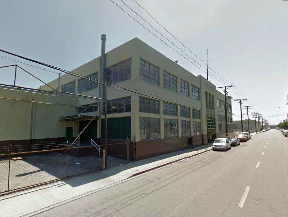
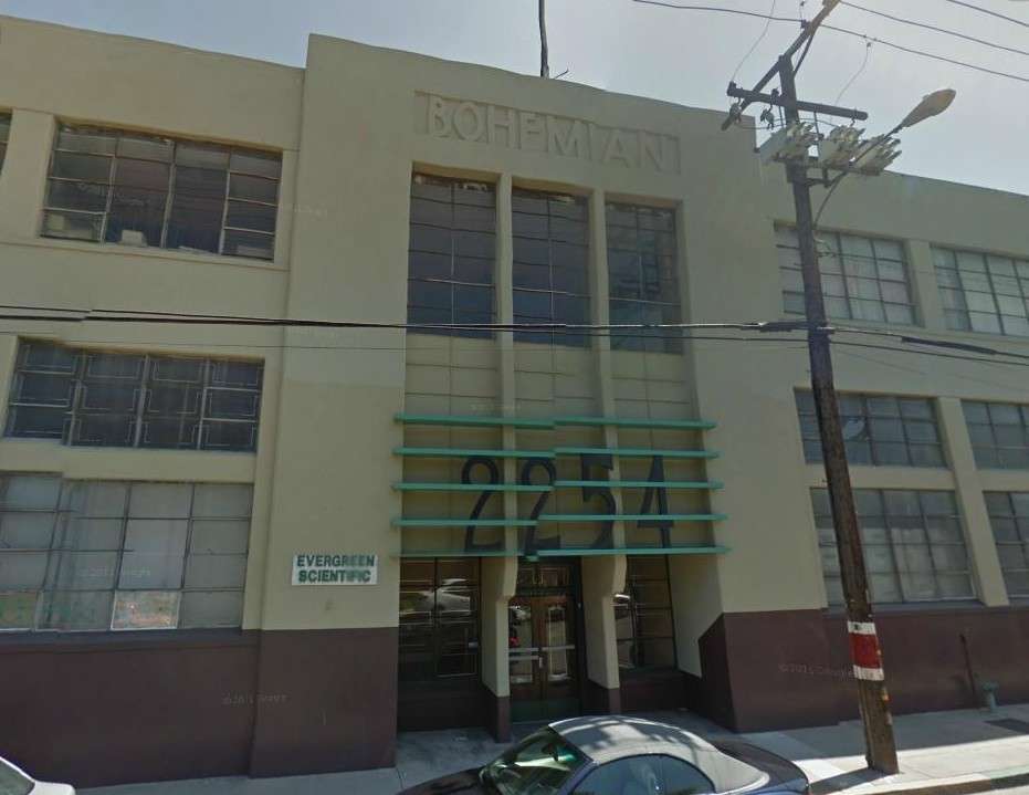
You're a true-blue friend for changing my 'bohfmian' to 'bohemian'! What a dolt I can be.
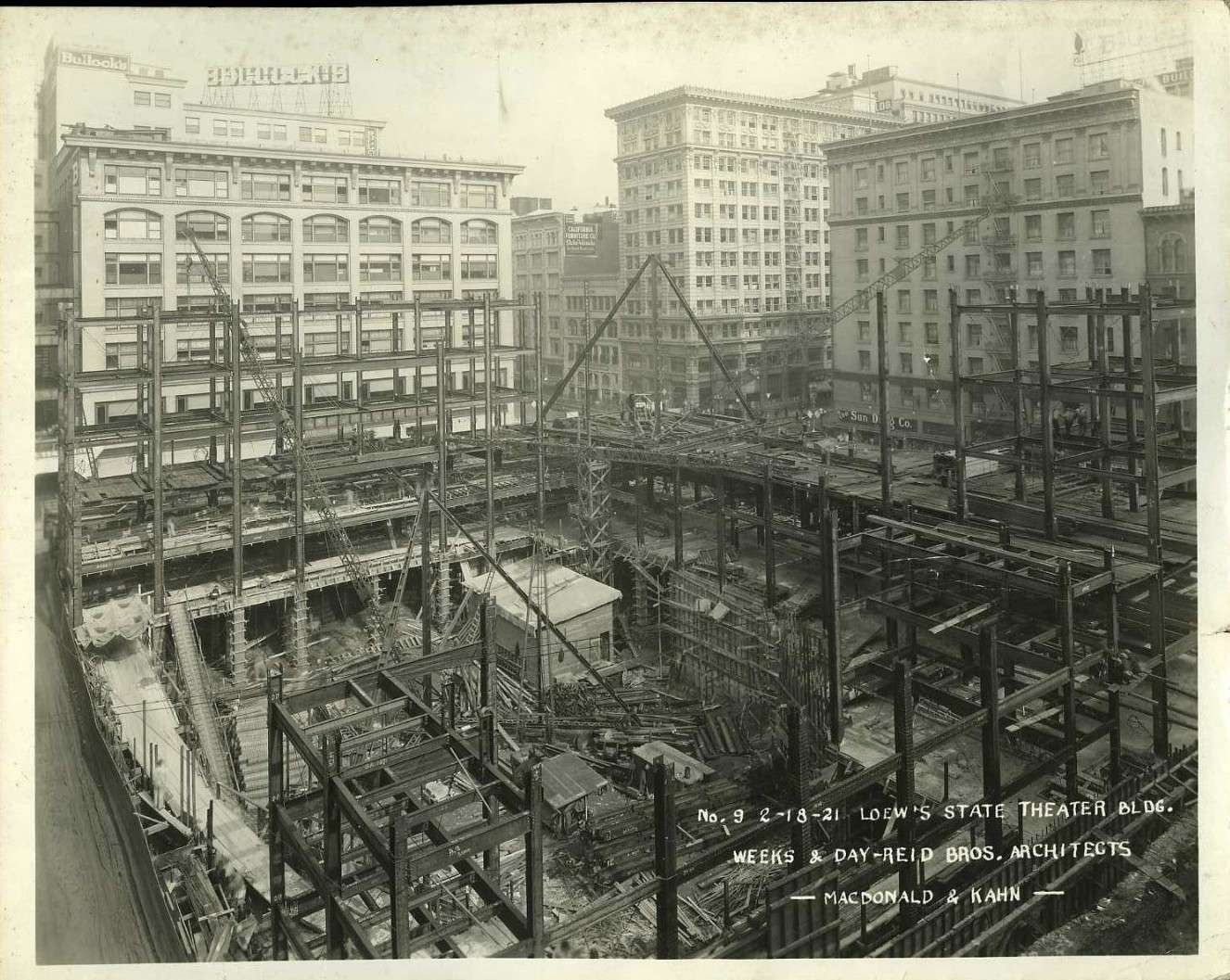
__

Last edited by ethereal_reality; Jul 14, 2013 at 2:45 AM.
Reply With Quote
     
     
  #15575  
Old Posted Jul 14, 2013, 2:11 AM
ethereal_reality's Avatar
ethereal_reality ethereal_reality is offline
Registered User
 
Join Date: Feb 2008
Location: Lafayette/West Lafayette IN, Purdue U.
Posts: 16,347
Quote:
Originally Posted by ethereal_reality View Post
Lowe's State 1924


below: I just found this tonight on ebay..."Construction of the Loew's State, circa Feb. 18, 1921".

What an impressive foundation! I wonder how many sub-basements were involved?

ebay

Can you imagine what's waiting to be discovered beneath the streets of downtown Los Angeles?
There must be thousands of nooks and crannies unseen for 50 or 60 years. -truly amazing.
__

Last edited by ethereal_reality; Jul 14, 2013 at 2:41 AM.
Reply With Quote
     
     
  #15576  
Old Posted Jul 14, 2013, 4:33 AM
Sonny☼LA Sonny☼LA is offline
Registered User
 
Join Date: Jun 2013
Posts: 31
Quote:
Originally Posted by Moxie View Post
I love the sun icon in your name...how'd you manage that?
If you're in Windows, it should be in your Character Map, found in Programs>Accessories, I think.

-------------------------------------------------------------------------

Got a couple photos I took of that streetcar depot at the Veterans Home, according to Wikipedia, a former Santa Monica Airlines depot:

"The Streetcar Depot on the grounds of the Sawtelle Veterans Home was designed in conjunction with the Wadsworth Chapel by J. Lee Burton in 1900. Both were listed in the National Register of Historic Places in 1972.

This station was formerly the terminus of the "Soldier's Home Branch," a short extension of the "Santa Monica Air Line" (what is now the Expo Line), starting at Home Junction and continuing north in a (still somewhat intact) private right-of-way on the west side of Sawtelle Boulevard to end at this station."
-Wikipedia


-My Flickr


-My Flickr
Reply With Quote
     
     
  #15577  
Old Posted Jul 14, 2013, 5:31 AM
Lorendoc Lorendoc is offline
Registered User
 
Join Date: May 2013
Location: Los Angeles, California
Posts: 428
Lookout Mountain Park

Quote:
Originally Posted by ethereal_reality View Post
Lorendoc, you mention the Lookout Mountain Inn being built in 1912 (as does most other sources), but the article below is dated Oct. 1910.

Is this an earlier hotel that was located on the same site?


''Garden of Allah'?....'Daughters of the Revolution'?...I obviously have some googling to do.
__
e_r I agree with your 1910 date - it says so right on the printed page Plus the image of the building looks like the other pictures of the hotel that have been posted elsewhere in this thread.

The Los Angeles Times of 2/11/12 has a note "New Hotel to Open: The Lookout Mountain Inn is to be opened formally today. It was built recently, near Laurel Canyon, and is expected to prove an attraction for autoists." So maybe they had a (very) soft opening in 1910.

The Times of 8/14/08 has the following:

Novel.

Line through Laurel Canyon to Lookout Mountain.

Plan of Syndicate That Has Just Bought Land Near West Hollywood Is to Make Peaks Accessible to Sightseers and to Create Resorts for Pleasure-seekers.

A scenic railway up Laurel Cañon and along the mountain rim of Lookout Mountain Park is the latest attraction planned near Los Angeles. A syndicate composed of several prominent local and eastern men, of whom A.B. Salisbury is the only visible representative, has purchased the park from F.B. Yoakum for a reported consideration of $98,000 [approx. $2.5M today], and is formulating plans for a unique pleasure resort. The deal for the park was negotiated by L.R. Conklin, with Bryan & Bradford.

Lookout Mountain Park consists of a 280-acre tract of hill and mountain land, lying about a mile from the fine residence section of West Hollywood, and is the head of the west branch of Laurel Cañon. There are three prominent peaks in the tract, all connected by an unbroken mountain rim a mile and a half long, which is one of the surprising formations of the section. Lookout Mountain is 1250 feet high, Wonderland Peak, formerly known as Mount Washington, 1300 feet, and Wulff's Peak, 1350 feet high. The former is at the southeast corner of the park, Wonderland Peak at the southwest corner, and Wulff's Peak at the northwest.

A wagon road, also available to automobiles, is already constructed, and connects all three. The scenic railway as planned will follow the route of the wagon road, and probably will connect with the Los Angeles-Pacific line, now within a few hundred feet of Laurel Cañon. The wagon road has cost about $35,000 [$910,000] to date. About $100,000 [$2.6M] will be invested in the new railway, it is said.

The Lookout Mountain Park Land and Water Company is the new concern. It will be incorporated at once. In addition to building the railroad, the company plans to develop water, reforest the hill slopes wherever necessary, planting pine and eucalyptus trees, and will also build a hotel and a number of bungalows. The latter are designed for renting to summer campers.

"Nowhere is there such a combination of hills, valleys and mountain rims," said Salisbury yesterday. "I do not think it can be duplicated for scenery of a more beautiful and varied character, and I think it cannot help but become one of the great show places and pleasure resorts of Southern California."

The Los Angeles-Pacific Railway tunnel will place the park within thirty minutes of the Los Angeles business center.


As for the DAR and the Garden of Allah, I can only think that Google's master file of All Things That Exist sometimes causes strange results when linked to their maps. I defer to the tunnel archaeologists on this thread on the matter of the "Los Angeles-Pacific Railway tunnel" - I am thinking it might be the Hill Street tunnels? The timing seems right.

I will puzzle over the Wulff's Peak-Wonderland Peak-Lookout Mountain trio and see if I can find more maps. At the LAPL today, I looked at the microfilm original of:


but wasn't able to see the street names any more clearly than what's pictured above. The short street just off "Wonderland Boulevard" looks like "Holly Place" - which corresponds to what is there today.
Reply With Quote
     
     
  #15578  
Old Posted Jul 14, 2013, 1:10 PM
CityBoyDoug CityBoyDoug is offline
BANNED
 
Join Date: Apr 2013
Posts: 2,868
Slats..my favorite noirish lion

MGM MGM archives

Slats was the first lion used for the MGM studio logo. He was born at Dublin Zoo, Ireland on March 20, 1919. The photo above is Slats the Lion being filmed for his cinematic debut as the MGM Logo, c. 1924. Slats was used on all black-and-white MGM films between 1924 and 1928.
Slats was trained to growl rather than roar (although in the logo he did nothing but look around, his 'voice' was dubbed), and for the next couple of years, Slats would tour with MGM promoters to signify the studio's launch. Slats died in 1936. His fur pelt is now on display at the McPherson Museum, in Kansas.

Last edited by CityBoyDoug; Jul 14, 2013 at 2:15 PM.
Reply With Quote
     
     
  #15579  
Old Posted Jul 14, 2013, 2:49 PM
westcork westcork is offline
Registered User
 
Join Date: Jan 2011
Posts: 189
Is it my imagination? Or do the LA Times and Curbed LA find inspiration from Noirish LA? Two days after BifRayRock's great post, LA Times has this on their Web front page:


LA Times
Reply With Quote
     
     
  #15580  
Old Posted Jul 14, 2013, 2:52 PM
Moxie's Avatar
Moxie Moxie is offline
Registered User
 
Join Date: Apr 2012
Location: Illinois
Posts: 103
Quote:
Originally Posted by Sonny☼LA View Post
If you're in Windows, it should be in your Character Map, found in Programs>Accessories, I think.
Ah, that'll be the problem...I'm on a Mac, not Windows.
Reply With Quote
     
     
This discussion thread continues

Use the page links to the lower-right to go to the next page for additional posts

Reply

Go Back   SkyscraperPage Forum > Photography Forums > Found City Photos
Forum Jump


Forum Jump


All times are GMT. The time now is 12:01 AM.

     
SkyscraperPage.com - Archive - Privacy Statement - Top

Powered by vBulletin® Version 3.8.7
Copyright ©2000 - 2024, vBulletin Solutions, Inc.