HomeDiagramsDatabaseMapsForum About
     

Go Back   SkyscraperPage Forum > Photography Forums > Found City Photos

Reply

 
Thread Tools Display Modes
     
     
  #7681  
Old Posted May 7, 2012, 8:50 PM
fhammon fhammon is offline
Registered User
 
Join Date: Oct 2011
Location: Los Angeles, Ca.
Posts: 269
Quote:
Originally Posted by kznyc2k View Post
Another observation: I find it interesting that they went for realism of the street grid over realism of the region, and by that I mean they accurately reproduced every street between Hollywood and Downtown, and that's all they did -- no beaches, no hills, no Valley, no South Central......the very first time I drove around and realized this I got pretty heated, no joke. I can only imagine these areas will be rendered in LA Noire 2 -- assuming there'll be one!
Question/request for kznyc2k.
Is Union Station, Ferguson Alley, Old Chinatown etc. or the L.A. Plaza depicted in L.A. Noire?

Edit:
Actually I found this Youtube video but I 'd sure like to see some good screen captures. Pretty amazing what I've seen so far. Thanks for posting the stills.

http://www.youtube.com/watch?v=qdf1pg9MHT8


The L.A. Plaza is there but it looks like L.A. Noire didn't feel moved to include the Lugo House or the Dragon's Den in any detail. Probably no Jerry's Joint either.


http://forum.skyscraperpage.com/show...7s#post5130242

Maybe they'll be included later.

Here's a video showing the L.A. Noire featured landmarks:

http://www.youtube.com/watch?v=mq7HnsRftYM

Pico Hotel and the L.A. Plaza - "El Pueblo de Los Angeles" featured landmark:


http://www.gamesradar.com/la-noire-f...-guide/?page=8

Last edited by fhammon; May 7, 2012 at 10:21 PM.
Reply With Quote
     
     
  #7682  
Old Posted May 7, 2012, 9:26 PM
MichaelRyerson's Avatar
MichaelRyerson MichaelRyerson is offline
Registered User
 
Join Date: Feb 2011
Location: Houston, Texas
Posts: 1,155
Quote:
Originally Posted by BifRayRock View Post


The photos appear to be from the late 70's. Judging from the theater marquee, the neighborhood was (and perhaps still is) at a crossroads. (It is unlikely the young man from the '50s - is in the 70's photo with a cane. He knew he was a good candidate for being struck in the crosswalk of that busy intersection or mugged for his shoes. He therefor moved to Downey and worked in aerospace. He is currently retired and living with his daughter in Fresno.)

Builders Emporium
on the NW corner (now occupied by OSH) was a natural place for local industry people to shop for rare spackling compound and counter-clockwise drywall screws - when Sears on Western and Santa Monica Blvd was out of stock and Koontz Hardware in W. Hollywood, Sears on San Vicente and Pico, Larchmont Hardware, and B&B (Washington Blvd.) - were too far to be inconvenienced.

http://www.google.com/search?q=build...w=1280&bih=812

http://www.flickr.com/photos/65359853@N00/5846073038/


Pico and Rimpau Sears:
http://www.google.com/imgres?q=sears...9,r:5,s:0,i:80

http://www.google.com/imgres?q=sears...9,r:8,s:0,i:86

http://digitallibrary.usc.edu/search...=1335541320350http://digitallibrary.usc.edu/search...=1335541320350


http://www.google.com/imgres?q=build...9,r:5,s:0,i:79

http://www.yelp.com/biz_photos/Xxkem...djn7UiZWoLNgfA

With a bucket full of poetic license - and if the Planets were in proper alignment - you should be able to hitchhike to the Sears at Pico and San Vicente. Upon discovery that they did not have the product you needed, you notice the Pacific Electric street car over the viaduct and decide to hop on and visit the Santa Monica Sears. Along the way you enjoy traveling Santa Monica Blvd. to what would later become Century City, ponder whether to audit a class or two at UCLA when crossing Westwood Blvd, and then wake up in Santa Monica and hope the Sears is open late. Getting home might be another matter especially since you left your wallet on the Streetcar.

http://www.uncanny.net/~wetzel/smline.htmhttp://www.uncanny.net/~wetzel/smline.htm

http://www.flickr.com/photos/38310569@N02/5106181129/http://digitallibrary.usc.edu/search...=1335541320350

Eventually, after many delays (due to Bulldozer crew's misplacing of their hardhats, overalls and sunglasses) the Freeway would be partially completed. After sticking around long enough to borrow a Packard 120 and take advantage of the Freeway, you notice the Sears in the far right of the picture and then realize you missed your turnoff as the car begins to sputter and run out of gas.


http://digitallibrary.usc.edu/search...=1335541320350
The Sears Roebuck on Santa Monica Blvd, just east of Western Ave, was the store in which my family shopped back in the late forties/early fifties. I remember the wonder of sneaking into the shoe department with my little brother (even when we didn't 'need' shoes) and standing up on the console xray machine (flouroscope?) to see our toes wiggling in our shoes. Some fun!
Reply With Quote
     
     
  #7683  
Old Posted May 7, 2012, 11:04 PM
MichaelRyerson's Avatar
MichaelRyerson MichaelRyerson is offline
Registered User
 
Join Date: Feb 2011
Location: Houston, Texas
Posts: 1,155
Quote:
Originally Posted by ethereal_reality View Post
I still need my monkey fix.
Actually, I believe Monkey Island was farther up the pass, near the summit at 3300Cahuenga Blvd. In fact, legend has it the old Hanna-Barberra Studios were built on the site and with their address being 3400 it is certainly possible. If you go to the Historic Aerials website so thoughtfully provided by srk1941 in post #7508 this thread, enter 3300 Cahuenga Blvd, Los Angeles, Ca, punch up the 1948 image (the earliest available) I think you can still see the remnants of Monkey Island as it shows three structures near the street and the island itself just behind off the street surrounded by a still substantial fence. Mostly vacant property in the immediate area but there is evidence of some heavy construction equipment being used. I think Monkey Island's days were truly numbered. If I'm right.
Reply With Quote
     
     
  #7684  
Old Posted May 8, 2012, 1:48 AM
BifRayRock BifRayRock is offline
Registered User
 
Join Date: Apr 2012
Posts: 1,366
Quote:
Originally Posted by MichaelRyerson View Post
The Sears Roebuck on Santa Monica Blvd, just east of Western Ave, was the store in which my family shopped back in the late forties/early fifties. I remember the wonder of sneaking into the shoe department with my little brother (even when we didn't 'need' shoes) and standing up on the console xray machine (flouroscope?) to see our toes wiggling in our shoes. Some fun!
I can only recall the store from its final post-bunker period when the walls appeared capable of withstanding who-knows-what and there was one exit manned by security. It was fairly obvious that things had changed, and not necessarily for the better. As you noted in an earlier post, the difference in appearance between old and new was dramatic.

From your earlier post, p 139:


A photo from page 325 of this thread seems particularly appropos:


"Looking west from the south side of the 6600 block of Sunset Boulevard in Hollywood. There is a fluoroscope business, where a $2 complete x-ray fluroscopic [sic] examination lets you "see your own organs with your own eyes" and the House of Westmore (6638 Sunset Boulevard), a beauty salon owned by the Westmore family of makeup fame. The sign for Wolf's Market can be seen in the background. Circa 1940."

and from page 28 of this thread (GW!):
Reply With Quote
     
     
  #7685  
Old Posted May 8, 2012, 1:58 AM
BifRayRock BifRayRock is offline
Registered User
 
Join Date: Apr 2012
Posts: 1,366
Quote:
Originally Posted by MichaelRyerson View Post
Actually, I believe Monkey Island was farther up the pass, near the summit at 3300Cahuenga Blvd. In fact, legend has it the old Hanna-Barberra Studios were built on the site and with their address being 3400 it is certainly possible. If you go to the Historic Aerials website so thoughtfully provided by srk1941 in post #7508 this thread, enter 3300 Cahuenga Blvd, Los Angeles, Ca, punch up the 1948 image (the earliest available) I think you can still see the remnants of Monkey Island as it shows three structures near the street and the island itself just behind off the street surrounded by a still substantial fence. Mostly vacant property in the immediate area but there is evidence of some heavy construction equipment being used. I think Monkey Island's days were truly numbered. If I'm right.
Monkey Island miscellaneous: http://walmart666.blogspot.com/2007/...ey-island.html

Ebay
Reply With Quote
     
     
  #7686  
Old Posted May 8, 2012, 2:53 AM
westcork westcork is offline
Registered User
 
Join Date: Jan 2011
Posts: 189
Quote:
Originally Posted by BifRayRock View Post
[COLOR="Indigo"][SIZE="2"][FONT="Tahoma"]I can only recall the store from its final post-bunker period when the walls appeared capable of withstanding who-knows-what and there was one exit manned by security. It was fairly obvious that things had changed, and not necessarily for the better. As you noted in an earlier post, the difference in appearance between old and new was dramatic.

From your earlier post, p 139:
There's a reason that Sears looks the way it does today:


http://www.flickr.com/photos/6535985...8115/lightbox/
Reply With Quote
     
     
  #7687  
Old Posted May 8, 2012, 4:36 AM
ethereal_reality's Avatar
ethereal_reality ethereal_reality is offline
Registered User
 
Join Date: Feb 2008
Location: Lafayette/West Lafayette IN, Purdue U.
Posts: 16,346
That is a powerful photo westcork.

The scene is reminiscent of Nathanael West's 'The Day of the Locust'.


http://www.flickr.com/photos/6535985...8115/lightbox/

___

Last edited by ethereal_reality; May 8, 2012 at 5:19 AM.
Reply With Quote
     
     
  #7688  
Old Posted May 8, 2012, 5:29 AM
ethereal_reality's Avatar
ethereal_reality ethereal_reality is offline
Registered User
 
Join Date: Feb 2008
Location: Lafayette/West Lafayette IN, Purdue U.
Posts: 16,346
An apothecary in Los Angeles 1910s.


ebay


ebay

Sorry, no address.....it's interesting nonetheless.
Reply With Quote
     
     
  #7689  
Old Posted May 8, 2012, 5:36 AM
ethereal_reality's Avatar
ethereal_reality ethereal_reality is offline
Registered User
 
Join Date: Feb 2008
Location: Lafayette/West Lafayette IN, Purdue U.
Posts: 16,346
Figueroa Street, downtown Los Angeles 1977.


http://www.flickr.com/photos/32196921@N06/6240780919/

....and today.


google street view
Reply With Quote
     
     
  #7690  
Old Posted May 8, 2012, 1:54 PM
3940dxer 3940dxer is offline
You can call me David
 
Join Date: Nov 2011
Location: Burbank
Posts: 271
Quote:
Originally Posted by MichaelRyerson View Post
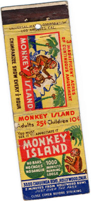
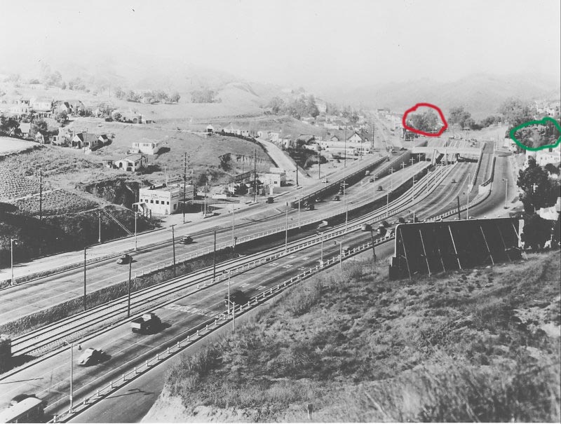
Actually, I believe Monkey Island was farther up the pass, near the summit at 3300 Cahuenga Blvd. In fact, legend has it the old Hanna-Barberra Studios were built on the site and with their address being 3400 it is certainly possible. If you go to the Historic Aerials website so thoughtfully provided by srk1941 in post #7508 this thread, enter 3300 Cahuenga Blvd, Los Angeles, Ca, punch up the 1948 image (the earliest available) I think you can still see the remnants of Monkey Island as it shows three structures near the street and the island itself just behind off the street surrounded by a still substantial fence. Mostly vacant property in the immediate area but there is evidence of some heavy construction equipment being used. I think Monkey Island's days were truly numbered. If I'm right.
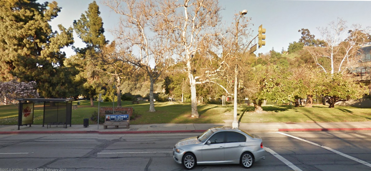
I think you're right. A couple of weeks ago I went exploring with a local gentleman I know from work. He is now 80, and his parents took him to Monkey Island a few times when he was about 8. He felt quite sure it was on the "island" shaped site between Mulholland and Hillpark Drive. As has been pointed out the address of 3300 doesn't square with this location, but we thought that perhaps, with all the changes to those roads over the years, the addresses were reassigned at some point.

Armed with a large print of one and only clear photo of MI (from the Hollywood Historic Photos site) we drove to several spots along Cahuenga West, trying to match the profile of the hills in that photo to what is seen today.

Unfortunately, the exercise was inconclusive. Tree growth now hides the lines of the hills, and buildings and other construction make it hard to match the perspective and sight lines of the original pic. We could only agree that MI might have been at the South of Mulholland location, and 
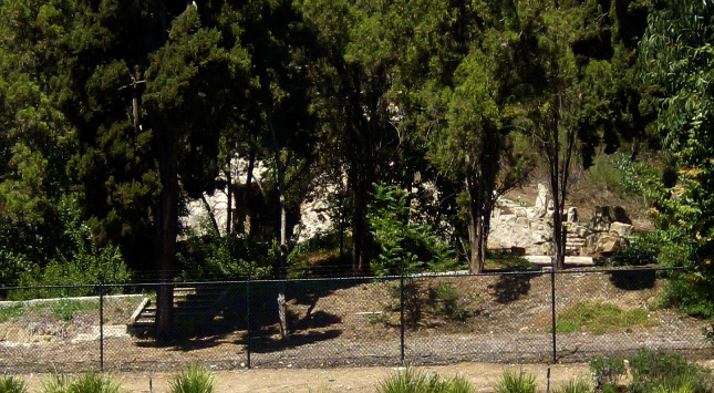
might have been just South of the Hanna Barbera building, where there is now a small park (with no visible remains of MI).

The more I think about it, the less likely it seems that the street numbers were changed. I'll go back and study the aerial you mention; that indeed may a good clue. I'll also re-visit the park site, and study the hills more closely. Maybe I can try to sketch the hill profile, mentally erasing the trees from it.

While it's hard to be certain without more evidence, I feel 90% sure that the site of Monkey Island is now El Paseo De Cahuenga Park, at 3300 Cahuenga Blvd. West (the same address as MI), just North of Barham. There is small plaque on the grounds; a memorial to the 9-11 fire fighters. Parts of MI may also have been on the the current H-B property.


http://maps.google.com/maps

Last edited by 3940dxer; May 8, 2012 at 2:14 PM.
Reply With Quote
     
     
  #7691  
Old Posted May 8, 2012, 3:06 PM
Chuckaluck Chuckaluck is offline
Registered User
 
Join Date: Apr 2012
Posts: 649
Quote:
Originally Posted by 3940dxer View Post
I As has been pointed out the address of 3300 doesn't square with this location, but we thought that perhaps, with all the changes to those roads over the years, the addresses were reassigned at some point.
The Monkey Island Miscellaneous link supports the theory that the street addresses could have been changed. The following is taken directly from that link http://walmart666.blogspot.com/2007/...ey-island.html

"While the address of Monkey island read 3300 Cahuenga Blvd. the actual address is now a public park with no indication that monkey island existed. There are some interesting foundations just on the other side of the freeway. This closely matched the description of Monkey Island. Its a prime place and ... who knows... the numbering of the streets may have very well changed in the past 80 years. This may simply be the remains of the estate that once was at the corner of Barham and Cahuenga. The interesting thing is that it has a mock hill and a little cave and about a 150 foot foundation.
This is a photo of the new Hollywood freeway going thru the Cahuenga pass. (note that creepy bathhouse-esque FANSCAPE building is at the corner of Barham and Cahuenga. its still there. Who knew it was that old!) The red "circle" is the address of Monkey Island and the green "circle" is where I found the mystery foundation on the other side of the freeway. This foundation is inside the fenceline of universal studios. It is not a set. it is clearly the foundation for an outdoor plaza of some sort. There was an estate here at one point but I have yet to find pictures of it.


The only picture I have located with the estate partially visible is :


". . . . . . . . . . . . . . . . . . . . . . . . . . . . . "

"Monkey Island

This unusual amusement was located at 3300 Cahuenga Boulevard, on the Valley side of Cahuenga Pass—the Times usually described it as on Ventura Boulevard. Operated by Adolph Weiss, Monkey Island opened December 9, 1938. A large herd of monkeys, numbering in the hundreds, roamed over an "island" about 150 feet long, with a 40-foot plastic mountain, surrounded by moats and covered with netting. There were palm trees, swings and billy oats for the monkeys to amuse themselves, and waterfalls where they could keep cool. Visitors paid to come in and watch the monkeys and feed them peanuts and vegetables. When the moats were drained in August, 1940, about 100 monkeys fled. Weiss calmly told police "they'll be back," and most apparently did return at feeding time. Escapes were common.
Filmaker Warren Miller recalls monkey island: "I had come to visit a new tourist attraction that was built right near the first Valley stop on The Pacific Electric Railroad, the route of the Big Red Cars. Some investor had built a 40-foot-high, fake plaster and cement mountain and surrounded it with a 20-foot-wide moat of slimy, green, stagnant water. The attraction was 100 undernourished, morose monkeys sitting on the concrete mountain watching you watching them. For 10 cents, you could watch the monkeys. For another five cents, you could buy a bag of peanuts and throw them to the monkeys." When Monkey Island closed is unknown. It is now a city park. "

http://walmart666.blogspot.com/2007/...ey-island.html
Reply With Quote
     
     
  #7692  
Old Posted May 8, 2012, 3:43 PM
Chuckaluck Chuckaluck is offline
Registered User
 
Join Date: Apr 2012
Posts: 649
Quote:
Originally Posted by westcork View Post
There's a reason that Sears looks the way it does today:
It probably goes without saying that in someone's mind, changes are always supposed to be good for retail and attract business. If the "Hollywood" Sears was profitable - enough, along with a majority of other Sears stores, it still might be open. There are a lot of tangibles and intangibles to consider, including leases, location and product line.

I would venture to guess there are a lot of reasons for the architectural style changes, but in this case I believe the remodel occurred much earlier then the 1990s and it may have been incremental. I am no fan of the latest look, but the simple bread-box exterior would have been less expensive to accomplish than a lot of ginger bread which might have dated the place before its time. I would be curious to know whether the original store (1927?) was air conditioned and whether it was originally equipped with industrial "fluorescent" lighting, or more likely, when those things were added. That would have drastically altered the thinking respecting all of the windows. Notice, for example, the Drive-in facade on the 1950s North Hollywood Store.
http://www.flickr.com/photos/6535985...6593/lightbox/

Shame more buildings like the Westwood Sears aren't around.

http://www.flickr.com/photos/6535985...8081/lightbox/

Could you order a DC3 from the Sears Catalog?:
http://www.flickr.com/photos/6535985...4980/lightbox/
Reply With Quote
     
     
  #7693  
Old Posted May 8, 2012, 5:20 PM
Handsome Stranger's Avatar
Handsome Stranger Handsome Stranger is offline
Registered User
 
Join Date: May 2011
Location: Los Angeles, CA
Posts: 395
Quote:
Originally Posted by GaylordWilshire View Post
I don't drive in Los Angeles regularly, but someone once told me that nowadays such "darting" is accepted in that, when the light turns green, oncoming traffic expects at least one car to turn from the opposing turning lane.... I've never tried it... but Rex, is this true?
For what it's worth, I do a fair amount of driving all over Los Angeles and surrounding cities, and I've never seen that particular maneuver. What I do see happening...all too often...is knuckleheads who use the right hand turn lane at lighted intersections as a passing lane. Instead of turning right, they step on the gas as soon as the light turns green, go through the intersection, and swerve back into traffic. It's bad enough when one or two cars at a time do this, but I know certain intersections where it's not uncommon to see six, seven, eight cars all trying to do the same thing at the same time. Of course that wreaks havoc on trafffic.
Reply With Quote
     
     
  #7694  
Old Posted May 8, 2012, 6:01 PM
3940dxer 3940dxer is offline
You can call me David
 
Join Date: Nov 2011
Location: Burbank
Posts: 271
Quote:
Originally Posted by Chuckaluck View Post
The Monkey Island Miscellaneous link supports the theory that the street addresses could have been changed. The following is taken directly from that link http://walmart666.blogspot.com/2007/...ey-island.html

"While the address of Monkey island read 3300 Cahuenga Blvd. the actual address is now a public park with no indication that monkey island existed. There are some interesting foundations just on the other side of the freeway. This closely matched the description of Monkey Island. Its a prime place and ... who knows... the numbering of the streets may have very well changed in the past 80 years. This may simply be the remains of the estate that once was at the corner of Barham and Cahuenga. The interesting thing is that it has a mock hill and a little cave and about a 150 foot foundation.
This is a photo of the new Hollywood freeway going thru the Cahuenga pass. (note that creepy bathhouse-esque FANSCAPE building is at the corner of Barham and Cahuenga. its still there. Who knew it was that old!) The red "circle" is the address of Monkey Island and the green "circle" is where I found the mystery foundation on the other side of the freeway. This foundation is inside the fenceline of universal studios. It is not a set. it is clearly the foundation for an outdoor plaza of some sort. There was an estate here at one point but I have yet to find pictures of it.


Yes, I read those pages after I first learned about Monkey Island. In the old B&W view above, which looks north towards the valley, I think the area circled in red (now the park) is correct and the one circled in green (also interesting, and worth a little sleuthing some day) is home to some other relic.

The green circled area on the East side of the pass doesn't seem to match the photo but also, it is on a fairly steep slope. I don't see how it would have supported visitor parking.

The little map on the matchbook is a good clue, but that's confusing too because Cahuenga was changed so many times. In the very early days it skirted the west side of the pass, becoming Ventura Blvd. somewhere near Monkey Island. (The older roadway would have been to the left of the red circle.)

The matchbook map shows MI east of the roadway. In today's world this would definitely put Monkey Island in the green area, but in 1938 (and remember, this place was only there for about 2 years), with the roadway on the west edge of the pass, both the red and the green areas would agree with the map.

Definitely tricky! I might check an old plat book downtown some day, if I can access it -- that would confirm the location for sure.

Last edited by 3940dxer; May 9, 2012 at 12:42 AM.
Reply With Quote
     
     
  #7695  
Old Posted May 8, 2012, 6:42 PM
ethereal_reality's Avatar
ethereal_reality ethereal_reality is offline
Registered User
 
Join Date: Feb 2008
Location: Lafayette/West Lafayette IN, Purdue U.
Posts: 16,346
Quote:
Originally Posted by Chuckaluck View Post
The red "circle" is the address of Monkey Island and the green "circle" is where I found the mystery foundation on the other side of the freeway. This foundation is inside the fenceline of universal studios. It is not a set. it is clearly the foundation for an outdoor plaza of some sort.
I bet there are monkey bones on the correct site. Any one up for a middle of the night visit with a shovel?
Reply With Quote
     
     
  #7696  
Old Posted May 8, 2012, 6:49 PM
ethereal_reality's Avatar
ethereal_reality ethereal_reality is offline
Registered User
 
Join Date: Feb 2008
Location: Lafayette/West Lafayette IN, Purdue U.
Posts: 16,346
A very nice house located at 2203 Rogers Avenue at Chicago Street. Winter 1903-04.


found on ebay


ebay


ebay


reverse side of first photo
Reply With Quote
     
     
  #7697  
Old Posted May 8, 2012, 9:01 PM
fhammon fhammon is offline
Registered User
 
Join Date: Oct 2011
Location: Los Angeles, Ca.
Posts: 269
Quote:
Originally Posted by ethereal_reality View Post
A very nice house located at 2203 Rogers Avenue at Chicago Street. Winter 1903-04.


found on ebay


If you go this address via Google streetview, you'll notice that maybe one or both of the houses are still present but much altered. I could be wrong but the two house I'm seeing should be old enough. It's possible that the featured house burned down a decade or so after it was built.
Reply With Quote
     
     
  #7698  
Old Posted May 8, 2012, 9:29 PM
ethereal_reality's Avatar
ethereal_reality ethereal_reality is offline
Registered User
 
Join Date: Feb 2008
Location: Lafayette/West Lafayette IN, Purdue U.
Posts: 16,346
Quote:
Originally Posted by fhammon View Post
"A photograph taken in 1924, looking south towards the Baldwin Hills. The Heinz 57 concrete numbers are
visible on the side of the Baldwin Hills.
LAPL"


I found this 'mystery' photo on an old cd of mine. pls. scan right--->


I can't remember/maybe ebay

I never knew where this was located until I recalled fhammon's post on the Heinz 57 sign overlooking Baldwin Village.

Does anyone recognize this 'monument/sculpture' to Richfield Oil ? It seems to be placed in an empty field....a defunct oil field perhaps?
The 'base' looks like it could be temporary...especially where it meets the grass on the right hand side.
The material looks rather cheap and the seams are shoddy (again on the right hand side).
___


Another connection to the 'mystery' photograph is the sculptor Finn Haakon Frolich.

I came across this photo during my recent research on Frolich's 'Jack London' House located on the dead-end La Vista Court.
Sure enough, it's the same sculpture!


http://paradiseleased.wordpress.com/...-to-hollywood/


below: Here's a smaller view of the 'mystery' photo.


unknown


http://speedwayposters.amazonwebstor...B0019J8FJE.htm

__

Last edited by ethereal_reality; May 9, 2012 at 2:05 AM.
Reply With Quote
     
     
  #7699  
Old Posted May 8, 2012, 9:46 PM
Graybeard's Avatar
Graybeard Graybeard is offline
Comfortably Numb
 
Join Date: Apr 2012
Location: Houston, Texas
Posts: 117
Quote:
Originally Posted by fhammon View Post
If you go this address via Google streetview, you'll notice that maybe one or both of the houses are still present but much altered. I could be wrong but the two house I'm seeing should be old enough. It's possible that the featured house burned down a decade or so after it was built.
The house on the right of the featured house appears to still be there. The lot that the featured house sits on now has 2 small houses on it.
Reply With Quote
     
     
  #7700  
Old Posted May 8, 2012, 11:31 PM
fhammon fhammon is offline
Registered User
 
Join Date: Oct 2011
Location: Los Angeles, Ca.
Posts: 269
Quote:
Originally Posted by Graybeard View Post
The house on the right of the featured house appears to still be there. The lot that the featured house sits on now has 2 small houses on it.
Yes. I see it now. I was looking on the wrong side of the street. Here's a shot of the "house behind the house" identifiable by the diamond shaped attic vents.
That's a nice looking Craftsman but it can't be too much older than the Victorian. 20 years max. maybe.
Seems a shame since in the photo, the featured house looks brand new without even proper landscaping yet. The people were obviously proud of it.


ETA.
I just noticed the vacant lot next to the Victorian between the two houses in the photo. The Craftsman could have been built at any time after they became fashionable.
Reply With Quote
     
     
This discussion thread continues

Use the page links to the lower-right to go to the next page for additional posts

Reply

Go Back   SkyscraperPage Forum > Photography Forums > Found City Photos
Forum Jump


Forum Jump


All times are GMT. The time now is 7:01 PM.

     
SkyscraperPage.com - Archive - Privacy Statement - Top

Powered by vBulletin® Version 3.8.7
Copyright ©2000 - 2024, vBulletin Solutions, Inc.